- Author
- Eshleman, Henry Frank,
- Date of Publication
- 1908
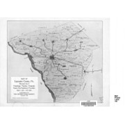
" and
Bryn Mawr. (Bryn Mawr is on the
Pennsylvania railroad, and one of the
stations.) He says, also, at page
368, that what we are accustomed to
call Montgomery avenue or Lancaster
Road, extending from High street
(now Market street) to Lancaster,
was formerly known as the old Con-
estoga Road, but was