It appears no script is enabled within your browser. Please enable JavaScript to use this site.
Skip header and navigation
Toggle navigation
Collections
Search
Help
Privacy
Your Selections:
0
Items
Staff Login
Revise Search
Revise Search
Revise search
Search
Data Source
Library
×
Data Source
All
A
B
C
D
E
F
G
H
I
J
K
L
M
N
O
P
Q
R
S
T
U
V
W
X
Y
Z
Sort
By Count
Alphabetical
Filtered by
Filter
Loading...
Subject
Lancaster County (Pa.) - Maps.
9
Lancaster (Pa.) - Maps.
4
Pennsylvania - Maps.
3
Cemeteries - Pennsylvania - Lancaster (Lancaster County, Pa. : Township)
2
Conestoga Memorial Park (Lancaster, Pa.) - Maps.
2
Lancaster (Lancaster County, Pa. : Township) - Maps.
2
Amish Country (Pa.) - Maps, Tourist.
1
Berks County (Pa.) - Maps.
1
Bus travel - Pennsylvania - Lancaster - Maps.
1
Bus travel - Pennsylvania - Lancaster County - Maps.
1
Canals - Maps.
1
Canals - Maryland - Maps.
1
More
×
Subject
All
A
B
C
D
E
F
G
H
I
J
K
L
M
N
O
P
Q
R
S
T
U
V
W
X
Y
Z
Sort
By Count
Alphabetical
Filtered by
Filter
Loading...
Name
Champion Map Corporation.
2
Pennsylvania Dutch Tourist Bureau.
2
Beers, D. G.
1
Beers, F. W.
1
Conestoga Transportation Company.
1
Everts and Stewart.
1
Fagan, L.
1
G.M. Hopkins & Co.
1
Gaustad, Edwin S.
1
Geological Survey (U.S.)
1
Gray, Ormando Willis,
1
Higginbotham, Don.
1
More
×
Name
All
A
B
C
D
E
F
G
H
I
J
K
L
M
N
O
P
Q
R
S
T
U
V
W
X
Y
Z
Sort
By Count
Alphabetical
Filtered by
Filter
Loading...
Decade
1760s
1
1800s
1
1810s
2
1820s
2
1840s
1
1850s
1
1860s
2
1870s
3
1880s
4
1890s
6
1900s
3
1910s
7
1920s
9
1930s
44
1940s
15
1950s
14
1960s
31
1970s
1980s
19
1990s
24
2000s
21
×
Decade
All
A
B
C
D
E
F
G
H
I
J
K
L
M
N
O
P
Q
R
S
T
U
V
W
X
Y
Z
Sort
By Count
Alphabetical
Filtered by
Filter
Loading...
Material
Text
1017
Cartographic
Notated music
4
×
Material
All
A
B
C
D
E
F
G
H
I
J
K
L
M
N
O
P
Q
R
S
T
U
V
W
X
Y
Z
Sort
By Count
Alphabetical
Filtered by
Filter
Loading...
Online Media
PDF
1
×
Online Media
All
A
B
C
D
E
F
G
H
I
J
K
L
M
N
O
P
Q
R
S
T
U
V
W
X
Y
Z
Sort
By Count
Alphabetical
Filtered by
Filter
Loading...
Advanced Search
Help
more like: LHDO17692
1600s
1970s
Cartographic
Library
Sorted by
Relevance
Sort by Title
Expand All
Collapse All
List View
Gallery View
Print
10 records – page 1 of 1.
Prev
Next
Toggle Full Record
1872 historical topographical atlas of the state of Pennsylvania : with descriptions and county histories, with maps of all counties and major cities, historical, scientific and statistical, together with a map of the United States and territories
https://collections.lancasterhistory.org/en/permalink/lhdo18794
Author
Walling, Henry Francis,
Date of Publication
1977.
Call Number
912.748 W211
More detail
Responsibility
by Henry F. Walling and O. W. Gray.
Author
Walling, Henry Francis,
Place of Publication
Knightstown, Ind
Publisher
The Bookmark,
Date of Publication
1977.
Physical Description
146 p. : ill., maps ; 43 cm.
Notes
Scale of county maps 1:3000,000.
Includes indexes and directories.
Reprint of the 1872 ed. published by Stedman, Brown & Lyon, Philadelphia.
Subjects
Pennsylvania - Maps.
Pennsylvania - History.
Pennsylvania - Directories.
Additional Author
Walling, Henry Francis,
Gray, Ormando Willis,
Location
Lancaster History Library - Atlas
Call Number
912.748 W211
Less detail
More Like This
Permalink
Toggle Full Record
Historical atlas of religion in America
https://collections.lancasterhistory.org/en/permalink/lhdo1675
Author
Gaustad, Edwin S.
Edition
[Revised ed.]
Date of Publication
[1976, 1962].
Call Number
911 G274 Oversize
More detail
Author
Gaustad, Edwin S.
Edition
[Revised ed.]
Place of Publication
New York
Publisher
Harper & Row
Date of Publication
[1976, 1962].
Physical Description
189 p. maps (1 fold. col. in pocket) diagrs. 31 cm.
Notes
Includes bibliographies.
Summary
A statistical and geographical study of religions in America between 1800 and 1975.
Subjects
Ecclesiastical geography - United States
United States - Church history.
Location
Lancaster History Library - Book
Call Number
911 G274 Oversize
Less detail
More Like This
Permalink
Toggle Full Record
Atlas of the county of Montgomery and the state of Pennsylvania
https://collections.lancasterhistory.org/en/permalink/lhdo18986
Corporate Author
G.M. Hopkins & Co.
Date of Publication
1976]
Call Number
912.74812 B977
More detail
Responsibility
from actual surveys & official records. Compiled & published by G.M. Hopkins & Co. ... Philadelphia. 187l.
Corporate Author
G.M. Hopkins & Co.
Place of Publication
[Evansville, Ind
Publisher
Unigraphic,
Date of Publication
1976]
Physical Description
irreg. paging through p. 111 : maps ; 41 cm.
Series
Atlases of Montgomery Co., Pennsylvania, 1871-1877-1893 ; [v. 1]
Notes
Reproduction of 1871 edition.
Bound with: Scott, James D., Combination atlas map of Montgomery County; and Naeff, M.A., comp., Property atlas of Montgomery County, Pennsylvania.
Subjects
Real property - Pennsylvania - Montgomery County - Maps.
Montgomery County (Pa.) - Maps.
Pennsylvania - Maps.
Location
Lancaster History Library - Atlas
Call Number
912.74812 B977
Less detail
More Like This
Permalink
Toggle Full Record
Champion map of Lancaster, Pennsylvania, including a detailed map of Lancaster County
https://collections.lancasterhistory.org/en/permalink/lhdo15373
Corporate Author
Champion Map Corporation.
Date of Publication
[1977]
Call Number
974.815 LACI 522
More detail
Alternate Title
Map of Lancaster, Pennsylvania, city & county
Corporate Author
Champion Map Corporation.
Place of Publication
Charlotte, N.C
Publisher
Champion Map Corp.,
Date of Publication
[1977]
Physical Description
2 maps on 1 sheet : back to back, col. ; 60 x 50 cm. and 48 x 57 cm., folded to 23 x 11 cm.
Notes
City map shows radial distances.
Includes street and location indexes.
On verso: text, location index, location map and ill.
"GG-10-FM."
Scale [ca. 1:31,000] and [ca. 1:200,000].
Subjects
Streets - Pennsylvania - Lancaster - Maps.
Roads - Pennsylvania - Lancaster County - Maps.
Lancaster County (Pa.) - Maps.
Lancaster (Pa.) - Maps.
Location
Lancaster History Library - Map
Call Number
974.815 LACI 522
Less detail
More Like This
Permalink
Toggle Full Record
Route map of Conestoga Transportation Company, fixed-route bus system
https://collections.lancasterhistory.org/en/permalink/lhdo17599
Corporate Author
Lancaster City and County Joint Transit Authority (Pa.)
Date of Publication
1975]
Call Number
974.815 LACO 161
More detail
Corporate Author
Lancaster City and County Joint Transit Authority (Pa.)
Place of Publication
[Lancaster
Publisher
Lancaster Transit Authority; Conestoga Transportation Company,
Date of Publication
1975]
Physical Description
col. map 51 x 59 cm. fold. to 18 x 11 cm.
Notes
Title from verso.
"Effective January 6, 1975."
Includes index of county-division bus routes.
Text, maps of Lancaster (city) and central Lancaster, and index of bus routes on verso.
Scale ca. 1:96,000.
Subjects
Bus travel - Pennsylvania - Lancaster County - Maps.
Bus travel - Pennsylvania - Lancaster - Maps.
Local transit - Pennsylvania - Lancaster - Maps.
Central business districts - Pennsylvania - Lancaster - Maps.
Additional Corporate Author
Conestoga Transportation Company.
Location
Lancaster History Library - Map
Call Number
974.815 LACO 161
Less detail
More Like This
Permalink
Toggle Full Record
Atlas of Cumberland Co., Pennsylvania : from actual surveys by and under the direction of F. W. Beers
https://collections.lancasterhistory.org/en/permalink/lhdo19338
Author
Beers, F. W.
Date of Publication
c1976.
Call Number
912.74843 A881
More detail
Author
Beers, F. W.
Place of Publication
Carlisle, Pa
Publisher
Cumberland County Historical Society,
Date of Publication
c1976.
Physical Description
48, [6] leaves (2 fol.) : ill., maps ; 41 cm.
Notes
Reprint of the 1872 ed. published by F. W. Beers & Co., New York.
Includes business notices.
Contents
Township plans.--Boroughs.--Town plans.--Miscellaneous.
Subjects
Real property - Pennsylvania - Cumberland Co. - Maps.
Cumberland County (Pa.) - Maps.
Cumberland County (Pa.) - History.
Location
Lancaster History Library - Atlas
Call Number
912.74843 A881
Less detail
More Like This
Permalink
Toggle Full Record
Maps showing the development of Pennsylvania
https://collections.lancasterhistory.org/en/permalink/lhdo13812
Corporate Author
Pennsylvania. Dept. of Internal Affairs. Land Office Bureau.
Date of Publication
1976.
Call Number
912.748 P415
More detail
Responsibility
prepared in the Land Office Bureau, Department of Internal Affairs.
Corporate Author
Pennsylvania. Dept. of Internal Affairs. Land Office Bureau.
Place of Publication
Pittsburgh, PA
Publisher
J. Morris,
Date of Publication
1976.
Physical Description
1 atlas ([13] leaves) : maps ; 28 cm.
Notes
Reprint. Originally published: Harrisburg, Pa. : The Land Office Bureau, Department of Internal Affairs, 1920.
Subjects
Pennsylvania - Historical geography - Maps.
Pennsylvania - Administrative and political divisions - Maps.
Location
Lancaster History Library - Book
Call Number
912.748 P415
Less detail
More Like This
Permalink
Toggle Full Record
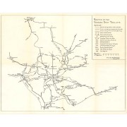
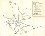
Routes of the Garden Spot Trolleys map
https://collections.lancasterhistory.org/en/permalink/lhdo5479
Date of Publication
1977.
Call Number
974.815 SEPA 102
More detail
1 document
Responsibility
Drawn by B. W. Rohrbeck.
Place of Publication
[s.l.]
Publisher
[s.n.] ,
Date of Publication
1977.
Physical Description
1 map ; 36 x 46 cm.
Notes
Includes route names.
Subjects
Street-railroads - Pennsylvania - Lancaster County
Transportation - Pennsylvania - Lancaster County
Lancaster County (Pa.) - Maps.
Location
Lancaster History Library - Map
Call Number
974.815 SEPA 102
Documents
map_974.815_SEPA_102_.pdf
Read PDF
Download PDF
Less detail
More Like This
Permalink
Toggle Full Record
Atlas of the American Revolution
https://collections.lancasterhistory.org/en/permalink/lhdo9922
Author
Nebenzahl, Kenneth,
Date of Publication
1974.
Call Number
911.4 H636 Oversize
More detail
Responsibility
map selection and commentary by Kenneth Nebenzahl ; narrative text by Don Higginbotham.
Author
Nebenzahl, Kenneth,
Place of Publication
Chicago
Publisher
Rand McNally,
Date of Publication
1974.
Physical Description
218 p. : col. ill., col. maps ; 39 cm.
Notes
Includes index.
Subjects
United States - History - Revolution, 1775-1783 - Maps.
Additional Author
Higginbotham, Don.
Additional Corporate Author
Rand McNally and Company.
Location
Lancaster History Library - Book
Call Number
911.4 H636 Oversize
Less detail
More Like This
Permalink
Toggle Full Record
[Map of Mount Joy, Pa. area]
https://collections.lancasterhistory.org/en/permalink/lhdo1860
Date of Publication
1971
Call Number
974.815 MJOT 100
More detail
Responsibility
Lancaster County Planning Commission.
Place of Publication
[Lancaster, Pa.]
Publisher
Lancaster County Planning Commission ,
Date of Publication
1971
Physical Description
1 map ; 56 x 86 cm
Notes
Includes portions of East Donegal, Mount Joy and Rapho townships.
Subjects
Land use - Pennsylvania - Lancaster County
Lancaster County (Pa.) - Maps.
Location
Lancaster History Library - Map
Call Number
974.815 MJOT 100
Less detail
More Like This
Permalink
10 records – page 1 of 1.
Prev
Next