Skip header and navigation

Revise Search

10 records – page 1 of 1.

Collection
Covered Bridge Album
Object ID
A-11-01-02
Date Range
1950
  1 image  
Object Name
Print, Photographic
Collection
Covered Bridge Album
Description
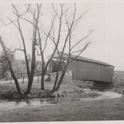
Isaac Shearer's Mill covered bridge, one mile north of Goodville in Caernarvon Township. County maintained on road T-773, built 1878, single span 88 feet long.
Date Range
1950
Creator
Gaintner, Jay Richard
Storage Location
LancasterHistory, Lancaster, PA
People
Shearer, Isaac
Subcategory
Documentary Artifact
Search Terms
Bridges
Covered bridges
Mills
Churchtown, Caernarvon Twp.
Conestoga River
Place
Caernarvon Twp.
Object Name
Print, Photographic
Print Size
8 x 10 inches
Object ID
A-11-01-02
Images
Less detail
Collection
Covered Bridge Album
Object ID
A-11-01-40
Date Range
1950
  1 image  
Object Name
Print, Photographic
Collection
Covered Bridge Album
Description
White Rock Forge, between Colerain and Little Britain Townships. County maintained on road T-337, built in 1847, single span 87 feet long.
Date Range
1950
Creator
Gaintner, Jay Richard
Storage Location
LancasterHistory, Lancaster, PA
Subcategory
Documentary Artifact
Search Terms
Bridges
Covered bridges
Forges
Octoraro Creek, West Branch
White Rock Covered Bridge
White Rock Forge
White Rock Forge Covered Bridge
White Rock, Little Britain Twp.
Object Name
Print, Photographic
Print Size
8 x 10 inches
Object ID
A-11-01-40
Images
Less detail
Collection
Covered Bridge Album
Object ID
A-11-01-12
Date Range
1950
  1 image  
Object Name
Print, Photographic
Collection
Covered Bridge Album
Description
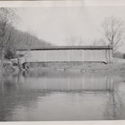
Slackwater, aslo known as Shober's Paper Mill, one mile south of Millersville between Conestoga and Manor Townships. State supervised on road LR 36008, oldest bridge still standing, built 1839, double span 269 feet long.
Date Range
1950
Creator
Gaintner, Jay Richard
Storage Location
LancasterHistory, Lancaster, PA
Subcategory
Documentary Artifact
Search Terms
Bridges
Covered bridges
Mills
Conestoga River
Slackwater, Conestoga Twp.
Object Name
Print, Photographic
Print Size
8 x 10 inches
Object ID
A-11-01-12
Images
Less detail
Collection
General Collection
Title
Photograph- White Rock covered bridge over the West Branch of the Octoraro Creek between Colerain and Little Britain townships.
Object ID
1-09-03-53
Date Range
September 1956
  1 image  
Object Name
Print, Photographic
Collection
General Collection
Title
Photograph- White Rock covered bridge over the West Branch of the Octoraro Creek between Colerain and Little Britain townships.
Description
White Rock covered bridge over the West Branch of the Octoraro Creek between Colerain and Little Britain townships.
Provenance
Lancaster County covered bridge photos taken by M. E. Schroll and Kathryn L. Sauder taken between 1956 and 1958.
Date Range
September 1956
Storage Location
LancasterHistory, Lancaster, PA
Subcategory
Documentary Artifact
Search Terms
Bridges
Colerain Twp.
Covered bridges
Creeks
Octoraro Creek, West Branch
White Rock Covered Bridge
White Rock Forge Covered Bridge
White Rock, Little Britain Twp.
Object Name
Print, Photographic
Print Size
3.5 x 3.5 inches
Condition
Good
Object ID
1-09-03-53
Images
Less detail
Collection
General Collection
Title
Photograph- White Rock covered bridge over the West Branch of the Octoraro Creek between Colerain and Little Britain townships.
Object ID
1-09-03-54
Date Range
August 4, 1958
  1 image  
Object Name
Print, Photographic
Collection
General Collection
Title
Photograph- White Rock covered bridge over the West Branch of the Octoraro Creek between Colerain and Little Britain townships.
Description
White Rock covered bridge over the West Branch of the Octoraro Creek between Colerain and Little Britain townships.
Provenance
Lancaster County covered bridge photos taken by M. E. Schroll and Kathryn L. Sauder taken between 1956 and 1958.
Date Range
August 4, 1958
Storage Location
LancasterHistory, Lancaster, PA
Subcategory
Documentary Artifact
Search Terms
Bridges
Colerain Twp.
Covered bridges
Creeks
Octoraro Creek, West Branch
White Rock Covered Bridge
White Rock Forge Covered Bridge
White Rock, Little Britain Twp.
Object Name
Print, Photographic
Print Size
3.5 x 3.5 inches
Condition
Good
Object ID
1-09-03-54
Images
Less detail
Collection
General Collection
Object ID
1-09-03-87
Date Range
August 1956
  1 image  
Object Name
Print, Photographic
Collection
General Collection
Description
Wabank Mill Bridge, also called Third Lock Bridge, on the Conestoga River between Lancaster and Pequea townships.
Provenance
Lancaster County covered bridge photos taken by M. E. Schroll and Kathryn L. Sauder taken between 1956 and 1958.
Date Range
August 1956
Storage Location
LancasterHistory, Lancaster, PA
Subcategory
Documentary Artifact
Search Terms
Bridges
Conestoga River
Covered bridges
Creeks
Lancaster Twp.
Mills
Pequea Twp.
Third Lock Bridge
Wabank Mill
Wabank Mill Bridge
Object Name
Print, Photographic
Print Size
3.5 x 3.5 inches
Condition
Good
Object ID
1-09-03-87
Images
Less detail
Collection
General Collection
Object ID
1-09-03-88
Date Range
August 7, 1958
  1 image  
Object Name
Print, Photographic
Collection
General Collection
Description
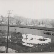
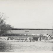
Wabank Mill bridge, also called Third Lock bridge, on the Conestoga River between Lancaster and Pequea townships. This bridge was replaced by a road relocation in 1958.
Provenance
Lancaster County covered bridge photos taken by M. E. Schroll and Kathryn L. Sauder taken between 1956 and 1958.
Date Range
August 7, 1958
Storage Location
LancasterHistory, Lancaster, PA
Subcategory
Documentary Artifact
Search Terms
Bridges
Conestoga River
Covered bridges
Creeks
Lancaster Twp.
Mills
Pequea Twp.
Third Lock Bridge
Wabank Mill
Wabank Mill Bridge
Object Name
Print, Photographic
Print Size
3.5 x 3.5 inches
Condition
Good
Object ID
1-09-03-88
Images
Less detail
Collection
Covered Bridge Album
Object ID
A-11-01-03
Date Range
1950
  1 image  
Object Name
Print, Photographic
Collection
Covered Bridge Album
Description
Israel Sensenig's covered bridge near Martindale in East Earl Township. State supervised on road LR 36013, built 1857, single span 65 feet long.
Date Range
1950
Creator
Gaintner, Jay Richard
Storage Location
LancasterHistory, Lancaster, PA
People
Sensenig, Israel
Subcategory
Documentary Artifact
Search Terms
Bridges
Covered bridges
Mills
Martindale, Earl Twp.
Conestoga River
Place
East Earl Twp.
Object Name
Print, Photographic
Print Size
8 x 10 inches
Object ID
A-11-01-03
Images
Less detail
Collection
Covered Bridge Album
Object ID
A-11-01-04
Date Range
1950
  1 image  
Object Name
Print, Photographic
Collection
Covered Bridge Album
Description
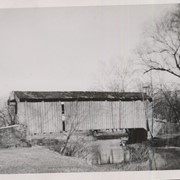
Isaac Bear's Mill covered bridge, one mile southwest of Martindale in East Earl Township. County maintained on road T-674, built in 1876, single span 94 feet long.
Date Range
1950
Creator
Gaintner, Jay Richard
Storage Location
LancasterHistory, Lancaster, PA
People
Bear, Isaac
Subcategory
Documentary Artifact
Search Terms
Bridges
Covered bridges
Mills
Martindale, Earl Twp.
Conestoga River
Place
East Earl Twp.
Object Name
Print, Photographic
Print Size
8 x 10 inches
Object ID
A-11-01-04
Images
Less detail
Collection
Covered Bridge Album
Object ID
A-11-01-06
Date Range
1950
  1 image  
Object Name
Print, Photographic
Collection
Covered Bridge Album
Description
Bushong's Mill, near Oregon between Upper Leacock and Manheim Townships. State supervised on road LR 36009, built in 1843, longest single span in the county, 195 feet long.
Date Range
1950
Creator
Gaintner, Jay Richard
Storage Location
LancasterHistory, Lancaster, PA
Subcategory
Documentary Artifact
Search Terms
Bridges
Covered bridges
Oregon, Manheim Twp.
Mills
Conestoga River
Object Name
Print, Photographic
Print Size
8 x 10 inches
Object ID
A-11-01-06
Images
Less detail

10 records – page 1 of 1.