Collection contains the research materials of R. Harold Barton on the mills and bridges of Lancaster County. Included are field notes, working papers, photographer's negatives, and postcards. Indexes are available listing mills by name and location, and bridges by name.
Four notebooks are the finished product of the mills and bridges research of R. Harold Barton. These notebooks are in the library under Barton, R. Harold on the online catalog (LC621.85, B283, v.1-v.4). The notebooks constitute 1 cubic ft. of the collection.
The remaining six boxes are located within the manuscript collection. These boxes house working papers, field notes, worksheets, notebooks, photographs, negatives, additional albums of photographs and other miscellaneous material relating to Lancaster County bridges and mills.
Mr. Barton uses a numerical system to locate bridges and mills by township or by the names of the streams, rivers, runs and creeks. Three indexes have been prepared: one lists the bridges by name, one the location by town or townships, and one the names of the mills.
There are a few notes related to Lancaster County gunsmiths, missionaries, and Indian traders.
System of Arrangement
Collection is arranged by township, number, and index.
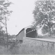
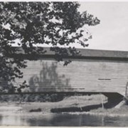
Photograph- Bell Bank covered bridge across the Octoraro Creek four miles south of Nine Points, between Colerain Township, Lancaster County and Upper Oxford Township, Chester County.
Photograph- Bell Bank covered bridge across the Octoraro Creek four miles south of Nine Points, between Colerain Township, Lancaster County and Upper Oxford Township, Chester County.
Description
Bell Bank covered bridge across the Octoraro Creek four miles south of Nine Points, between Colerain Township, Lancaster County and Upper Oxford Township, Chester County.
Provenance
Lancaster County covered bridge photos taken by M. E. Schroll and Kathryn L. Sauder taken between 1956 and 1958.
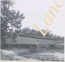
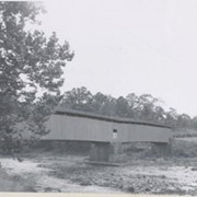
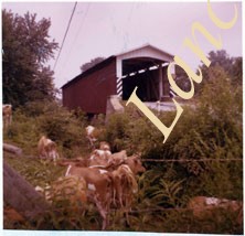
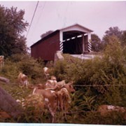
Photograph- Pine Grove covered bridge across the Octoraro Creek, between Little Britain Township, Lancaster County, and Lower Oxford Township, Chester County. Location of pumping station which supplies Chester.
Photograph- Pine Grove covered bridge across the Octoraro Creek, between Little Britain Township, Lancaster County, and Lower Oxford Township, Chester County. Location of pumping station which supplies Chester.
Description
Pine Grove Covered Bridge across the Octoraro Creek, between Little Britain Township, Lancaster County, and Lower Oxford Township, Chester County. Location of pumping station which supplies Chester.
Provenance
Lancaster County covered bridge photos taken by M. E. Schroll and Kathryn L. Sauder taken between 1956 and 1958.