It appears no script is enabled within your browser. Please enable JavaScript to use this site.
Skip header and navigation
Toggle navigation
Collections
Search
Help
Privacy
Your Selections:
0
Items
Staff Login
Revise Search
Revise Search
Revise search
Search
Data Source
Photographs
1912
×
Data Source
All
A
B
C
D
E
F
G
H
I
J
K
L
M
N
O
P
Q
R
S
T
U
V
W
X
Y
Z
Sort
By Count
Alphabetical
Filtered by
Filter
Loading...
Collection
General Collection
779
Lloyd E. Eckert Korean War Album
220
Paul Shaub - United Steel Workers Local 285 Photograph Collection
134
Mildred Shopf Smiley Photograph Collection
110
Ridgeway Travel Photograph Collection
93
Sarah Ann Stauffer Photograph Collection
82
James Buchanan Foundation Photograph Collection
75
Lancaster 250 Collection
51
Covered Bridge Album
50
John D. Denney, Jr. Photograph Collection
42
Bruce Ryder Photograph Collection
41
Johnny Hauck Photograph Collection
35
More
×
Collection
All
A
B
C
D
E
F
G
H
I
J
K
L
M
N
O
P
Q
R
S
T
U
V
W
X
Y
Z
Sort
By Count
Alphabetical
Filtered by
Filter
Loading...
Subject
Documentary Artifact
1900
Military
234
Korean War
223
Covered bridges
163
Labor unions
117
Lancaster Jaycees
89
Baseball
80
Wheatland
76
James Buchanan Presidential Library
75
Sports
73
Bridges
65
Family reunions
55
More
×
Subject
All
A
B
C
D
E
F
G
H
I
J
K
L
M
N
O
P
Q
R
S
T
U
V
W
X
Y
Z
Sort
By Count
Alphabetical
Filtered by
Filter
Loading...
Name
Gaintner, Jay Richard
50
Meyer, Francis E.
49
Bond, George Ross
32
Krone, Herbert
19
Schopf, Edward
18
Smiley, Mildred Shopf
18
Bare, Kendig
16
Lancaster Newspapers, Inc.
16
Walter, Ross
15
Hostetter, Harry B.
14
Warfel, Mary
14
Baker, Marian Louise
13
More
×
Name
All
A
B
C
D
E
F
G
H
I
J
K
L
M
N
O
P
Q
R
S
T
U
V
W
X
Y
Z
Sort
By Count
Alphabetical
Filtered by
Filter
Loading...
Place
Lancaster
408
Lancaster Twp.
82
Carlisle, Cumberland County, Pennsylvania
46
Manheim Twp.
29
Strasburg Twp.
21
Manor Twp.
13
York, York County, Pennsylvania
13
Columbia
10
Rapho Twp.
10
Ephrata Twp.
9
East Hempfield Twp.
8
Lebanon County, Pennsylvania
8
More
×
Place
All
A
B
C
D
E
F
G
H
I
J
K
L
M
N
O
P
Q
R
S
T
U
V
W
X
Y
Z
Sort
By Count
Alphabetical
Filtered by
Filter
Loading...
Decade
1020s
1
1070s
1
1190s
4
1740s
1
1800s
4
1820s
1
1840s
4
1850s
40
1860s
325
1870s
365
1880s
216
1890s
598
1900s
1152
1910s
1497
1920s
4065
1930s
3124
1940s
1866
1950s
1960s
1179
1970s
3378
1980s
1703
1990s
2751
2000s
1925
2010s
14
×
Decade
All
A
B
C
D
E
F
G
H
I
J
K
L
M
N
O
P
Q
R
S
T
U
V
W
X
Y
Z
Sort
By Count
Alphabetical
Filtered by
Filter
Loading...
Material
Probate
6577
Print, Photographic
Estate Inventory
511
Indictment
425
Record, Judicial
245
Petition
103
Documents
47
Archive
32
Negative
30
Statement, Financial
19
Transparency, Slide
13
Postcard
10
More
×
Material
All
A
B
C
D
E
F
G
H
I
J
K
L
M
N
O
P
Q
R
S
T
U
V
W
X
Y
Z
Sort
By Count
Alphabetical
Filtered by
Filter
Loading...
Online Media
Image
1912
×
Online Media
All
A
B
C
D
E
F
G
H
I
J
K
L
M
N
O
P
Q
R
S
T
U
V
W
X
Y
Z
Sort
By Count
Alphabetical
Filtered by
Filter
Loading...
Advanced Search
Help
more like: 99C09264-B2F1-4269-873B-393016030177
1760s
1950s
Print, Photographic
Sorted by
Relevance
Sort by Title
Expand All
Collapse All
List View
Gallery View
Print
10 records – page 1 of 1.
Prev
Next
Toggle Full Record
Print, Photographic
https://collections.lancasterhistory.org/en/permalink/4bbec65e-0210-44c9-9eec-452372049972
Collection
General Collection
Object ID
1-09-04-03
Date Range
August 5, 1958
More detail
1 image
Object Name
Print, Photographic
Collection
General Collection
Description
Zook's Mill covered bridge on the Cocalico Creek on Log Cabin Road west of Brownstown between West Earl and Warwick townships.
Provenance
Lancaster County covered bridge photos taken by M. E. Schroll and Kathryn L. Sauder taken between 1956 and 1958.
Date Range
August 5, 1958
Storage Location
LancasterHistory, Lancaster, PA
Subcategory
Documentary Artifact
Search Terms
Bridges
Brownstown, West Earl Twp.
Cocalico Creek
Covered bridges
Creeks
Log Cabin Road
Rose Hill Bridge
Warwick Twp.
West Earl Twp.
Zook's Mill
Object Name
Print, Photographic
Print Size
3.5 x 4.5 inches
Condition
Good
Object ID
1-09-04-03
Images
Less detail
More Like This
Permalink
Toggle Full Record
Print, Photographic
https://collections.lancasterhistory.org/en/permalink/adf748a2-38eb-4fbc-9b00-493564116246
Collection
General Collection
Title
Photograph- White Rock covered bridge over the West Branch of the Octoraro Creek between Colerain and Little Britain townships.
Object ID
1-09-03-53
Date Range
September 1956
More detail
1 image
Object Name
Print, Photographic
Collection
General Collection
Title
Photograph- White Rock covered bridge over the West Branch of the Octoraro Creek between Colerain and Little Britain townships.
Description
White Rock covered bridge over the West Branch of the Octoraro Creek between Colerain and Little Britain townships.
Provenance
Lancaster County covered bridge photos taken by M. E. Schroll and Kathryn L. Sauder taken between 1956 and 1958.
Date Range
September 1956
Storage Location
LancasterHistory, Lancaster, PA
Subcategory
Documentary Artifact
Search Terms
Bridges
Colerain Twp.
Covered bridges
Creeks
Octoraro Creek, West Branch
White Rock Covered Bridge
White Rock Forge Covered Bridge
White Rock, Little Britain Twp.
Object Name
Print, Photographic
Print Size
3.5 x 3.5 inches
Condition
Good
Object ID
1-09-03-53
Images
Less detail
More Like This
Permalink
Toggle Full Record
Print, Photographic
https://collections.lancasterhistory.org/en/permalink/aee09825-bd3d-4c64-85d9-210349253712
Collection
General Collection
Title
Photograph- White Rock covered bridge over the West Branch of the Octoraro Creek between Colerain and Little Britain townships.
Object ID
1-09-03-54
Date Range
August 4, 1958
More detail
1 image
Object Name
Print, Photographic
Collection
General Collection
Title
Photograph- White Rock covered bridge over the West Branch of the Octoraro Creek between Colerain and Little Britain townships.
Description
White Rock covered bridge over the West Branch of the Octoraro Creek between Colerain and Little Britain townships.
Provenance
Lancaster County covered bridge photos taken by M. E. Schroll and Kathryn L. Sauder taken between 1956 and 1958.
Date Range
August 4, 1958
Storage Location
LancasterHistory, Lancaster, PA
Subcategory
Documentary Artifact
Search Terms
Bridges
Colerain Twp.
Covered bridges
Creeks
Octoraro Creek, West Branch
White Rock Covered Bridge
White Rock Forge Covered Bridge
White Rock, Little Britain Twp.
Object Name
Print, Photographic
Print Size
3.5 x 3.5 inches
Condition
Good
Object ID
1-09-03-54
Images
Less detail
More Like This
Permalink
Toggle Full Record
Print, Photographic
https://collections.lancasterhistory.org/en/permalink/dd0e11ff-70e7-4dc0-8d36-073257198050
Collection
General Collection
Object ID
1-09-03-63
Date Range
August 1956
More detail
1 image
Object Name
Print, Photographic
Collection
General Collection
Description
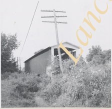
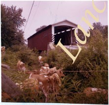
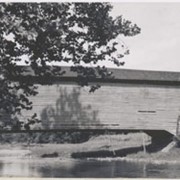
Herrville covered bridge across the Pequea Creek south of Lime Valley.
Provenance
Lancaster County covered bridge photos taken by M. E. Schroll and Kathryn L. Sauder taken between 1956 and 1958.
Date Range
August 1956
Storage Location
LancasterHistory, Lancaster, PA
Subcategory
Documentary Artifact
Search Terms
Bridges
Covered bridges
Herrville, Pequea Twp.
Lime Valley, West Lampeter Twp.
Pequea Creek
Object Name
Print, Photographic
Print Size
3.5 x 3.5 inches
Condition
Good
Object ID
1-09-03-63
Images
Less detail
More Like This
Permalink
Toggle Full Record
Print, Photographic
https://collections.lancasterhistory.org/en/permalink/4ae27840-0787-4b12-80cc-309352173194
Collection
General Collection
Object ID
1-09-03-64
Date Range
August 1958
More detail
1 image
Object Name
Print, Photographic
Collection
General Collection
Description
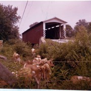
Herrville covered bridge on the Pequea Creek south of Lime Valley.
Provenance
Lancaster County covered bridge photos taken by M. E. Schroll and Kathryn L. Sauder taken between 1956 and 1958.
Date Range
August 1958
Storage Location
LancasterHistory, Lancaster, PA
Subcategory
Documentary Artifact
Search Terms
Bridges
Covered bridges
Herrville, Pequea Twp.
Lime Valley, West Lampeter Twp.
Pequea Creek
Object Name
Print, Photographic
Print Size
3.5 x 3.5 inches
Condition
Good
Object ID
1-09-03-64
Images
Less detail
More Like This
Permalink
Toggle Full Record
Print, Photographic
https://collections.lancasterhistory.org/en/permalink/69f030a4-faf6-466e-a4ad-467078315846
Collection
General Collection
Object ID
1-09-04-02
Date Range
July 1956
More detail
1 image
Object Name
Print, Photographic
Collection
General Collection
Description
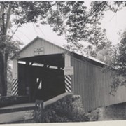
Zook's Mill covered bridge across the Cocalico Creek south of Akron between West Earl and Warwick townships.
Provenance
Lancaster County covered bridge photos taken by M. E. Schroll and Kathryn L. Sauder taken between 1956 and 1958.
Date Range
July 1956
Storage Location
LancasterHistory, Lancaster, PA
Subcategory
Documentary Artifact
Search Terms
Zook's Mill
Covered bridges
Cocalico Creek
Akron, Pennsylvania
West Earl Twp.
Warwick Twp.
Creeks
Rose Hill Bridge
Object Name
Print, Photographic
Print Size
3.5 x 4.5 inches
Condition
Good
Object ID
1-09-04-02
Images
Less detail
More Like This
Permalink
Toggle Full Record
Print, Photographic
https://collections.lancasterhistory.org/en/permalink/296c6673-3a37-4258-bea2-449609487490
Collection
General Collection
Title
Photograph- Side view of King's Bridge on the West Branch of the Octoraro northwest of White Rock, between Colerain and Little Britain townships.
Object ID
1-09-03-51
Date Range
September 1, 1958
More detail
1 image
Object Name
Print, Photographic
Collection
General Collection
Title
Photograph- Side view of King's Bridge on the West Branch of the Octoraro northwest of White Rock, between Colerain and Little Britain townships.
Description
Side view of King's Bridge on the West Branch of the Octoraro northwest of White Rock, between Colerain and Little Britain townships.
Provenance
Lancaster County covered bridge photos taken by M. E. Schroll and Kathryn L. Sauder taken between 1956 and 1958.
Date Range
September 1, 1958
Storage Location
LancasterHistory, Lancaster, PA
Subcategory
Documentary Artifact
Search Terms
Bridges
King's Bridge
Covered bridges
Octoraro Creek, West Branch
White Rock, Little Britain Twp.
Creeks
Object Name
Print, Photographic
Print Size
3.5 x 3.5 inches
Condition
Good
Object ID
1-09-03-51
Images
Less detail
More Like This
Permalink
Toggle Full Record
Print, Photographic
https://collections.lancasterhistory.org/en/permalink/5e93a77a-b151-4c88-95ba-423210273245
Collection
General Collection
Object ID
1-09-03-79
Date Range
August 13, 1958
More detail
1 image
Object Name
Print, Photographic
Collection
General Collection
Description
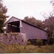
Bitzer's Mill covered bridge, also called Eberly's Cider Mill covered bridge, on the Conestoga River north of Fairmount.
Provenance
Lancaster County covered bridge photos taken by M. E. Schroll and Kathryn L. Sauder taken between 1956 and 1958.
Date Range
August 13, 1958
Storage Location
LancasterHistory, Lancaster, PA
Subcategory
Documentary Artifact
Search Terms
Bitzer's Mill
Covered bridges
Eberly's Cider Mill
Conestoga River
Fairmount, West Earl Twp.
Place
West Earl Twp.
Object Name
Print, Photographic
Print Size
3.5 x 3.5 inches
Condition
Good
Object ID
1-09-03-79
Images
Less detail
More Like This
Permalink
Toggle Full Record
Print, Photographic
https://collections.lancasterhistory.org/en/permalink/b2bafc66-5a5c-4223-af82-341496793242
Collection
General Collection
Object ID
1-09-03-80
Date Range
August 13, 1958
More detail
1 image
Object Name
Print, Photographic
Collection
General Collection
Description
Bitzer's Mill covered bridge, also called Eberly's Cider Mill covered bridge, on the Conestoga River north of Fairmount.
Provenance
Lancaster County covered bridge photos taken by M. E. Schroll and Kathryn L. Sauder taken between 1956 and 1958.
Date Range
August 13, 1958
Storage Location
LancasterHistory, Lancaster, PA
Subcategory
Documentary Artifact
Search Terms
Bitzer's Mill
Covered bridges
Eberly's Cider Mill
Conestoga River
Fairmount, West Earl Twp.
Place
West Earl Twp.
Object Name
Print, Photographic
Print Size
3.5 x 3.5 inches
Condition
Good
Object ID
1-09-03-80
Images
Less detail
More Like This
Permalink
Toggle Full Record
Print, Photographic
https://collections.lancasterhistory.org/en/permalink/1e9a2243-81fd-4997-9fc4-232342361435
Collection
Covered Bridge Album
Object ID
A-11-01-28
Date Range
1950
More detail
1 image
Object Name
Print, Photographic
Collection
Covered Bridge Album
Description
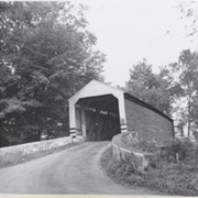
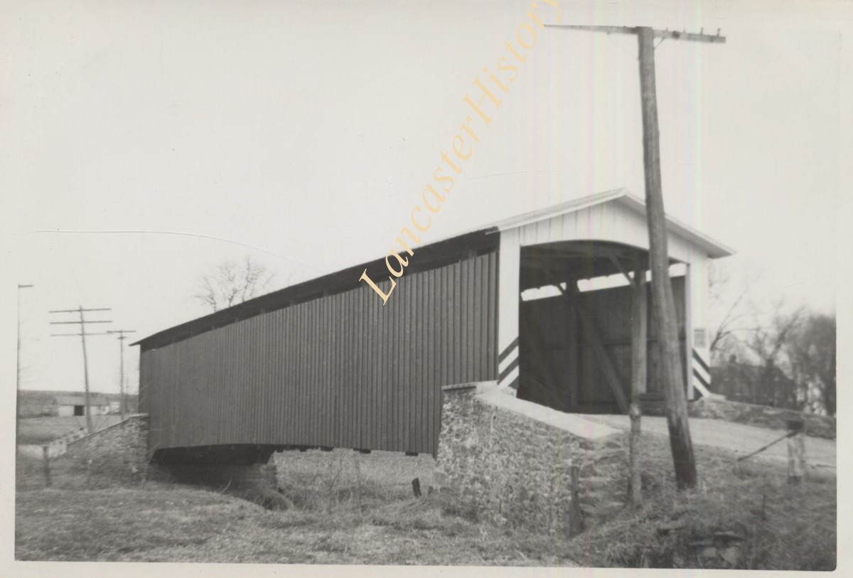
Hurtzinger's Mill, at Lime Valley, between Strasburg and West Lampeter Townships. County maintained on road T-498, built in 1871, single span 104 feet long.
Date Range
1950
Creator
Gaintner, Jay Richard
Storage Location
LancasterHistory, Lancaster, PA
Subcategory
Documentary Artifact
Search Terms
Bridges
Covered bridges
Mills
Pequea Creek
Lime Valley, West Lampeter Twp.
Object Name
Print, Photographic
Print Size
8 x 10 inches
Object ID
A-11-01-28
Images
Less detail
More Like This
Permalink
10 records – page 1 of 1.
Prev
Next