It appears no script is enabled within your browser. Please enable JavaScript to use this site.
Skip header and navigation
Toggle navigation
Collections
Search
Help
Privacy
Your Selections:
0
Items
Staff Login
Revise Search
Revise Search
Revise search
Search
Data Source
Library
20
×
Data Source
All
A
B
C
D
E
F
G
H
I
J
K
L
M
N
O
P
Q
R
S
T
U
V
W
X
Y
Z
Sort
By Count
Alphabetical
Filtered by
Filter
Loading...
Subject
Lancaster County (Pa.) - Maps.
11
Lancaster (Pa.) - Maps.
8
Cemeteries - Pennsylvania - Lancaster (Lancaster County, Pa. : Township)
2
Conestoga Memorial Park (Lancaster, Pa.) - Maps.
2
Lancaster (Lancaster County, Pa. : Township) - Maps.
2
Buildings - Pennsylvania - Lancaster
1
Bus travel - Pennsylvania - Lancaster - Maps.
1
Bus travel - Pennsylvania - Lancaster County - Maps.
1
Census districts - Pennsylvania - Lancaster County
1
Central business districts - Pennsylvania - Lancaster - Maps.
1
Conestoga Traction Company - Maps.
1
Electric railroads - Pennsylvania - Lancaster - Maps.
1
More
×
Subject
All
A
B
C
D
E
F
G
H
I
J
K
L
M
N
O
P
Q
R
S
T
U
V
W
X
Y
Z
Sort
By Count
Alphabetical
Filtered by
Filter
Loading...
Name
Champion Map Corporation.
2
Lancaster Chamber of Commerce (Pa.)
2
Conestoga Transportation Company.
1
Everts and Stewart.
1
Geological Survey (U.S.)
1
Global Graphics Inc.
1
Lancaster Automobile Club.
1
Lancaster City and County Joint Transit Authority (Pa.)
1
National Survey (Firm)
1
Parton, Ronald J.
1
Pennsylvania Dutch Tourist Bureau.
1
Pennsylvania. Bureau of Topographic and Geologic Survey.
1
More
×
Name
All
A
B
C
D
E
F
G
H
I
J
K
L
M
N
O
P
Q
R
S
T
U
V
W
X
Y
Z
Sort
By Count
Alphabetical
Filtered by
Filter
Loading...
Decade
1760s
1
1800s
1810s
1
1820s
2
1840s
1
1850s
1
1880s
4
1890s
5
1900s
3
1910s
1920s
8
1930s
20
1940s
10
1950s
15
1960s
27
1970s
1980s
11
1990s
11
2000s
15
×
Decade
All
A
B
C
D
E
F
G
H
I
J
K
L
M
N
O
P
Q
R
S
T
U
V
W
X
Y
Z
Sort
By Count
Alphabetical
Filtered by
Filter
Loading...
Material
Bond, Legal
1094
Probate
642
Text
460
Appraisal
442
Print, Photographic
410
Negative
103
Archive
98
Record, Judicial
62
Transparency, Slide
38
Badge, Fire
24
Cartographic
Estate Inventory
14
More
×
Material
All
A
B
C
D
E
F
G
H
I
J
K
L
M
N
O
P
Q
R
S
T
U
V
W
X
Y
Z
Sort
By Count
Alphabetical
Filtered by
Filter
Loading...
Online Media
PDF
1
×
Online Media
All
A
B
C
D
E
F
G
H
I
J
K
L
M
N
O
P
Q
R
S
T
U
V
W
X
Y
Z
Sort
By Count
Alphabetical
Filtered by
Filter
Loading...
Advanced Search
Help
more like: E16B54A5-AE37-4E7D-8769-445014492188
1800s
1910s
1970s
Cartographic
Sorted by
Relevance
Sort by Title
Expand All
Collapse All
List View
Gallery View
Print
10 records – page 1 of 1.
Prev
Next
Toggle Full Record
Map of Lawn Crypt Garden, Conestoga Memorial Park
https://collections.lancasterhistory.org/en/permalink/lhdo3290
Date of Publication
1973.
Call Number
7974.815 LACI 706
More detail
Responsibility
George Johnstone.
Place of Publication
Lancaster, Pa
Publisher
CMS east, inc. ,
Date of Publication
1973.
Physical Description
1 map : photocopy ; 61 x 91 cm.
Notes
Blue line print.
Subjects
Conestoga Memorial Park (Lancaster, Pa.) - Maps.
Cemeteries - Pennsylvania - Lancaster (Lancaster County, Pa. : Township)
Lancaster (Lancaster County, Pa. : Township) - Maps.
Location
Lancaster History Library - Map
Call Number
7974.815 LACI 706
Less detail
More Like This
Permalink
Toggle Full Record
Parcel plan, Garden of Love, Conestoga Memorial Park
https://collections.lancasterhistory.org/en/permalink/lhdo3291
Date of Publication
1978.
Call Number
700 505
More detail
Place of Publication
Lancaster, Pa
Publisher
Huth Engineers, Inc. ,
Date of Publication
1978.
Physical Description
1 map : photocopy ; 61 x 91 cm.
Notes
Blue line print. Gives lot numbers.
Subjects
Conestoga Memorial Park (Lancaster, Pa.) - Maps.
Cemeteries - Pennsylvania - Lancaster (Lancaster County, Pa. : Township)
Lancaster (Lancaster County, Pa. : Township) - Maps.
Location
Lancaster History Library - Map
Call Number
700 505
Less detail
More Like This
Permalink
Toggle Full Record
1875 historical atlas of Lancaster County, Pennsylvania
https://collections.lancasterhistory.org/en/permalink/lhdo15911
Corporate Author
Everts and Stewart.
Date of Publication
1976.
Call Number
912.74815 E93
More detail
Responsibility
compiled, drawn, and published from personal examinations and surveys by Everts & Stewart.
Corporate Author
Everts and Stewart.
Place of Publication
Knightstown, IN
Publisher
Bookmark,
Date of Publication
1976.
Physical Description
xviii, 120 p. : ill., maps, ports. ; 43 cm.
Notes
Reprint of the 1875 ed. published by Everts and Stewart, Philadelphia under title: Combination atlas map of Lancaster County, Pennsylvania.
"Sponsored by the Lancaster County Historical Society, Lancaster, Pennsylvania."
Kept on top of counter-height shelving unit in Reading Room.
Subjects
Real property - Pennsylvania - Lancaster Co. - Maps.
Lancaster County (Pa.) - Maps.
Lancaster County (Pa.) - Directories.
Lancaster County (Pa.) - History.
Additional Corporate Author
Everts and Stewart.
Location
Lancaster History Library - Reference
Call Number
912.74815 E93
Less detail
More Like This
Permalink
Toggle Full Record
Route map of Conestoga Transportation Company, fixed-route bus system
https://collections.lancasterhistory.org/en/permalink/lhdo17599
Corporate Author
Lancaster City and County Joint Transit Authority (Pa.)
Date of Publication
1975]
Call Number
974.815 LACO 161
More detail
Corporate Author
Lancaster City and County Joint Transit Authority (Pa.)
Place of Publication
[Lancaster
Publisher
Lancaster Transit Authority; Conestoga Transportation Company,
Date of Publication
1975]
Physical Description
col. map 51 x 59 cm. fold. to 18 x 11 cm.
Notes
Title from verso.
"Effective January 6, 1975."
Includes index of county-division bus routes.
Text, maps of Lancaster (city) and central Lancaster, and index of bus routes on verso.
Scale ca. 1:96,000.
Subjects
Bus travel - Pennsylvania - Lancaster County - Maps.
Bus travel - Pennsylvania - Lancaster - Maps.
Local transit - Pennsylvania - Lancaster - Maps.
Central business districts - Pennsylvania - Lancaster - Maps.
Additional Corporate Author
Conestoga Transportation Company.
Location
Lancaster History Library - Map
Call Number
974.815 LACO 161
Less detail
More Like This
Permalink
Toggle Full Record
Champion map of Lancaster, Pennsylvania, including a detailed map of Lancaster County
https://collections.lancasterhistory.org/en/permalink/lhdo15373
Corporate Author
Champion Map Corporation.
Date of Publication
[1977]
Call Number
974.815 LACI 522
More detail
Alternate Title
Map of Lancaster, Pennsylvania, city & county
Corporate Author
Champion Map Corporation.
Place of Publication
Charlotte, N.C
Publisher
Champion Map Corp.,
Date of Publication
[1977]
Physical Description
2 maps on 1 sheet : back to back, col. ; 60 x 50 cm. and 48 x 57 cm., folded to 23 x 11 cm.
Notes
City map shows radial distances.
Includes street and location indexes.
On verso: text, location index, location map and ill.
"GG-10-FM."
Scale [ca. 1:31,000] and [ca. 1:200,000].
Subjects
Streets - Pennsylvania - Lancaster - Maps.
Roads - Pennsylvania - Lancaster County - Maps.
Lancaster County (Pa.) - Maps.
Lancaster (Pa.) - Maps.
Location
Lancaster History Library - Map
Call Number
974.815 LACI 522
Less detail
More Like This
Permalink
Toggle Full Record
An indexed street map, enterprising Lancaster, Pa., U.S.A. : including Lancaster County
https://collections.lancasterhistory.org/en/permalink/lhdo19763
Corporate Author
Global Graphics Inc.
Date of Publication
c1971.
Call Number
974.815 LACI 143
More detail
Responsibility
issued through the cooperation of the Lancaster Chamber of Commerce ; compliments of Lancaster Auto Club, AAA Penna.
Corporate Author
Global Graphics Inc.
Place of Publication
Bethesda, Md
Publisher
Global Graphics,
Date of Publication
c1971.
Physical Description
1 map : col. ; 42 x 71 cm., on sheet 58 x 88 cm., folded to 29 x 22 cm.
Notes
Panel title.
Title in advertisement at bottom: Lancaster and vicinity map.
Includes advertisements.
Street index, Jan. 1970 map of Lancaster County with index to points of interest, phone directory, and advertisements on verso.
Subjects
Lancaster (Pa.) - Maps.
Lancaster Metropolitan Area (Pa.) - Maps.
Lancaster County (Pa.) - Maps, Tourist.
Additional Corporate Author
Lancaster Chamber of Commerce (Pa.)
Lancaster Automobile Club.
Location
Lancaster History Library - Map
Call Number
974.815 LACI 143
Less detail
More Like This
Permalink
Toggle Full Record
Champion map of Lancaster, Pennsylvania : including a detailed map of Lancaster County
https://collections.lancasterhistory.org/en/permalink/lhdo15008
Corporate Author
Champion Map Corporation.
Date of Publication
[1974]
Call Number
974.815 LACO 516
More detail
Alternate Title
Lancaster market
Responsibility
Copyright Champion Map Corporation, Ronald J. Parton, chief cartographer. [Prepared for Intelligencer Journal, Lancaster New Era, and Sunday News].
Corporate Author
Champion Map Corporation.
Place of Publication
Charlotte, N.C
Publisher
Champion Map Corporation,
Date of Publication
[1974]
Physical Description
2 maps on 1 sheet : both sides, 2 col., ill. ; 63 x 52 cm. and 52 x 59 cm. on sheet 92 x 61 cm., folded to 24 x 11 cm.
Notes
Folded title: Map of Lancaster City & County, Pennsylvania.
"Map no. GB-010-B."
Shows radial distances.
Indexed.
On verso with index: The Lancaster market.
"Printed: April 1974"--Panel.
Subjects
Lancaster (Pa.) - Maps.
Lancaster County (Pa.) - Maps.
Lancaster Region (Pa.) - Maps.
Additional Author
Parton, Ronald J.
Location
Lancaster History Library - Map
Call Number
974.815 LACO 516
Less detail
More Like This
Permalink
Toggle Full Record
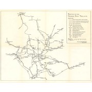
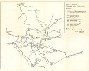
Routes of the Garden Spot Trolleys map
https://collections.lancasterhistory.org/en/permalink/lhdo5479
Date of Publication
1977.
Call Number
974.815 SEPA 102
More detail
1 document
Responsibility
Drawn by B. W. Rohrbeck.
Place of Publication
[s.l.]
Publisher
[s.n.] ,
Date of Publication
1977.
Physical Description
1 map ; 36 x 46 cm.
Notes
Includes route names.
Subjects
Street-railroads - Pennsylvania - Lancaster County
Transportation - Pennsylvania - Lancaster County
Lancaster County (Pa.) - Maps.
Location
Lancaster History Library - Map
Call Number
974.815 SEPA 102
Documents
map_974.815_SEPA_102_.pdf
Read PDF
Download PDF
Less detail
More Like This
Permalink
Toggle Full Record
Plan of Lancaster Penna 1800
https://collections.lancasterhistory.org/en/permalink/lhdo1731
Date of Publication
1800.
Call Number
974.815 LACI 116
More detail
Responsibility
P.E.M.
Place of Publication
[S.l.]
Publisher
[s.l.] ,
Date of Publication
1800.
Physical Description
1 map. photocopy : 35 x 28 cm.
Subjects
Buildings - Pennsylvania - Lancaster
Lancaster (Pa.) - Maps.
Location
Lancaster History Library - Map
Call Number
974.815 LACI 116
Less detail
More Like This
Permalink
Toggle Full Record
[Map of Mount Joy, Pa. area]
https://collections.lancasterhistory.org/en/permalink/lhdo1860
Date of Publication
1971
Call Number
974.815 MJOT 100
More detail
Responsibility
Lancaster County Planning Commission.
Place of Publication
[Lancaster, Pa.]
Publisher
Lancaster County Planning Commission ,
Date of Publication
1971
Physical Description
1 map ; 56 x 86 cm
Notes
Includes portions of East Donegal, Mount Joy and Rapho townships.
Subjects
Land use - Pennsylvania - Lancaster County
Lancaster County (Pa.) - Maps.
Location
Lancaster History Library - Map
Call Number
974.815 MJOT 100
Less detail
More Like This
Permalink
10 records – page 1 of 1.
Prev
Next