It appears no script is enabled within your browser. Please enable JavaScript to use this site.
Skip header and navigation
Toggle navigation
Collections
Search
Help
Privacy
Your Selections:
0
Items
Staff Login
Revise Search
Revise Search
Revise search
Search
Data Source
Photographs
3121
×
Data Source
All
A
B
C
D
E
F
G
H
I
J
K
L
M
N
O
P
Q
R
S
T
U
V
W
X
Y
Z
Sort
By Count
Alphabetical
Filtered by
Filter
Loading...
Collection
Darmstaetter Collection
3006
General Collection
79
DeWalt Products Collection
24
Lancaster Recreation Commission Photograph Collection
9
Bowman Technical School Photograph Collection
1
Johnny Hauck Photograph Collection
1
Steinman Hardware Photograph Collection
1
×
Collection
All
A
B
C
D
E
F
G
H
I
J
K
L
M
N
O
P
Q
R
S
T
U
V
W
X
Y
Z
Sort
By Count
Alphabetical
Filtered by
Filter
Loading...
Subject
Documentary Artifact
3119
Dwellings
191
Factories
80
Military
80
Automobiles
64
World War I
64
Soldiers
58
Uniforms
58
Houses
56
Employees
54
Construction
52
Portraits
49
More
×
Subject
All
A
B
C
D
E
F
G
H
I
J
K
L
M
N
O
P
Q
R
S
T
U
V
W
X
Y
Z
Sort
By Count
Alphabetical
Filtered by
Filter
Loading...
Name
Register of Wills
6580
County Commissioners
4335
Darmstaetter's
Landis, David Bachman
793
Orphans' Court
171
Smith, John
99
Miller, John
79
Pennsylvania. Court of Common Pleas (Lancaster County)
76
Miller, Mary
54
Miller, Henry
53
Miller, Jacob
53
Ryder, Bruce
53
More
×
Name
All
A
B
C
D
E
F
G
H
I
J
K
L
M
N
O
P
Q
R
S
T
U
V
W
X
Y
Z
Sort
By Count
Alphabetical
Filtered by
Filter
Loading...
Place
Lancaster
1267
Manheim Twp.
79
Manheim
60
Lancaster Twp.
53
Mount Joy
28
Columbia
26
East Hempfield Twp.
25
Lititz
24
New Holland
15
Elizabethtown
13
Millersville
11
Ephrata
8
More
×
Place
All
A
B
C
D
E
F
G
H
I
J
K
L
M
N
O
P
Q
R
S
T
U
V
W
X
Y
Z
Sort
By Count
Alphabetical
Filtered by
Filter
Loading...
Decade
1020s
1
1190s
4
1720s
1
1820s
2
1890s
1
1900s
34
1910s
284
1920s
1930s
1497
1940s
23
1950s
2
×
Decade
All
A
B
C
D
E
F
G
H
I
J
K
L
M
N
O
P
Q
R
S
T
U
V
W
X
Y
Z
Sort
By Count
Alphabetical
Filtered by
Filter
Loading...
Material
Print, Photographic
2415
Negative
696
Negative, Glass Plate
6
Negative, Sheet Film
3
Transparency, Slide
1
×
Material
All
A
B
C
D
E
F
G
H
I
J
K
L
M
N
O
P
Q
R
S
T
U
V
W
X
Y
Z
Sort
By Count
Alphabetical
Filtered by
Filter
Loading...
Online Media
Image
3117
×
Online Media
All
A
B
C
D
E
F
G
H
I
J
K
L
M
N
O
P
Q
R
S
T
U
V
W
X
Y
Z
Sort
By Count
Alphabetical
Filtered by
Filter
Loading...
Advanced Search
Help
more like: 5F58E4EF-9540-4971-874D-011722330483
1830s
1920s
1980s
Darmstaetter's
Sorted by
Relevance
Sort by Title
Expand All
Collapse All
List View
Gallery View
Print
10 records – page 1 of 1.
Prev
Next
Toggle Full Record
Negative
https://collections.lancasterhistory.org/en/permalink/7723bebb-3aa3-432f-abec-170944938900
Collection
Darmstaetter Collection
Title
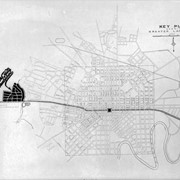
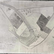
Photograph- Plan for Greater Lancaster showing Wheatland Hills.
Object ID
D-07-03-55
Date Range
January 24, 1927
More detail
1 image
Object Name
Negative
Collection
Darmstaetter Collection
Title
Photograph- Plan for Greater Lancaster showing Wheatland Hills.
Description
Plan for Greater Lancaster showing Wheatland Hills. 1 print only
Date Range
January 24, 1927
Storage Location
LancasterHistory, Lancaster, PA
Studio
Darmstaetter's
Subcategory
Documentary Artifact
Classification
Maps
Place
East Hempfield Twp.
Object Name
Negative
Film Size
10 x 8 inches
Object ID
D-07-03-55
Negative Number
yes
Other Number
660-257
Images
Less detail
More Like This
Permalink
Toggle Full Record
Negative
https://collections.lancasterhistory.org/en/permalink/cfeaaee4-cdc4-4b21-aef9-829150874936
Collection
Darmstaetter Collection
Title
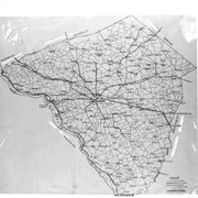
Photograph- Map of Lancaster County.
Object ID
D-07-03-53
Date Range
1926/02/22
More detail
1 image
Object Name
Negative
Collection
Darmstaetter Collection
Title
Photograph- Map of Lancaster County.
Description
Map of Lancaster County. 1 print only
Date Range
1926/02/22
Year Range From
1926
Storage Location
LancasterHistory, Lancaster, PA
Studio
Darmstaetter's
Subcategory
Documentary Artifact
Classification
Maps
Place
Lancaster County
Object Name
Negative
Film Size
10 x 8 inches
Object ID
D-07-03-53
Negative Number
yes
Other Number
642-435
Images
Less detail
More Like This
Permalink
Toggle Full Record
Negative
https://collections.lancasterhistory.org/en/permalink/23988159-db5d-4ca5-b01e-153188656558
Collection
Darmstaetter Collection
Title
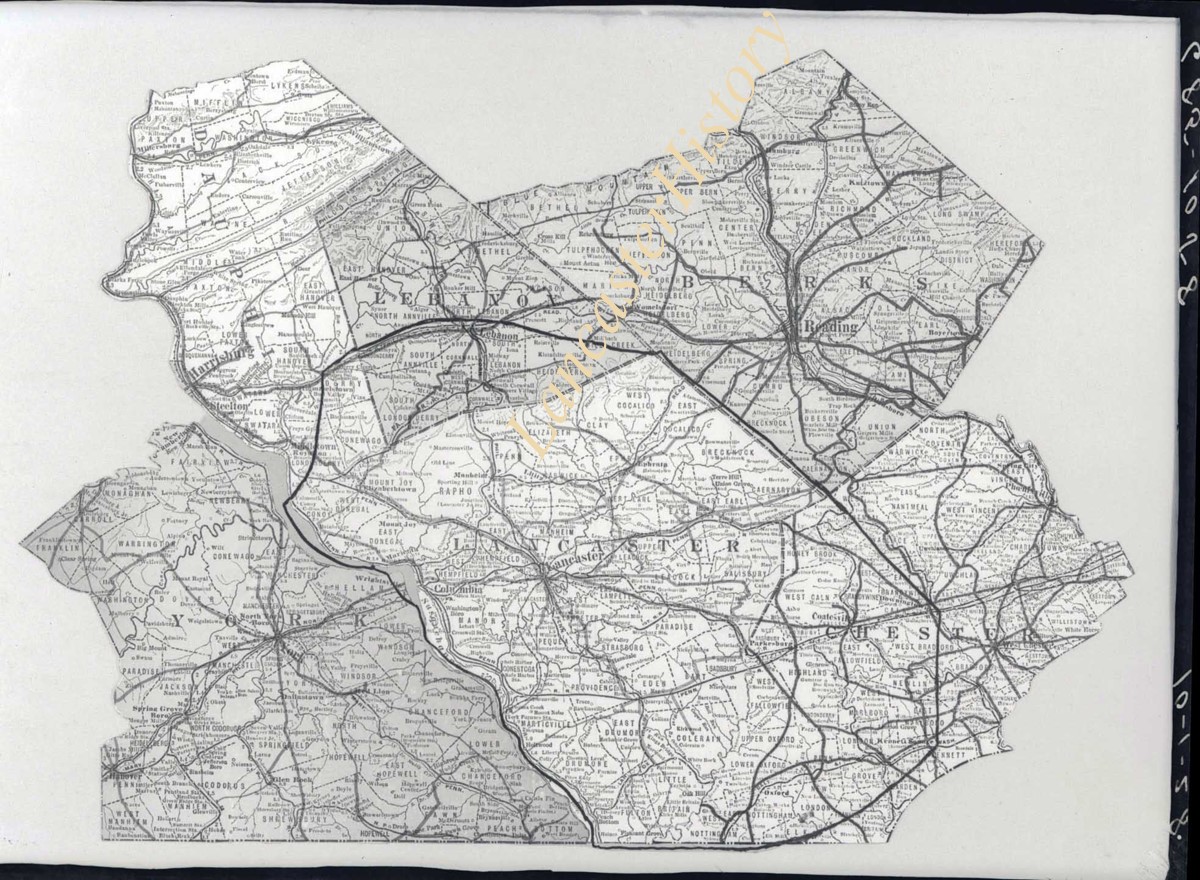
Photograph- Map showing Berks, Lebanon, York, Chester, and Lancaster Counties.
Object ID
D-07-03-52
Date Range
1928/10/01
More detail
1 image
Object Name
Negative
Collection
Darmstaetter Collection
Title
Photograph- Map showing Berks, Lebanon, York, Chester, and Lancaster Counties.
Description
Map showing Berks, Lebanon, York, Chester, and Lancaster Counties. 1 print only
Date Range
1928/10/01
Year Range From
1928
Storage Location
LancasterHistory, Lancaster, PA
Studio
Darmstaetter's
Subcategory
Documentary Artifact
Classification
Maps
Object Name
Negative
Film Size
6.5 x 5 inches
Object ID
D-07-03-52
Negative Number
yes
Other Number
685-1058
Images
Less detail
More Like This
Permalink
Toggle Full Record
Negative
https://collections.lancasterhistory.org/en/permalink/7bf4d352-83bc-411e-b713-389752566549
Collection
Darmstaetter Collection
Title
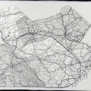
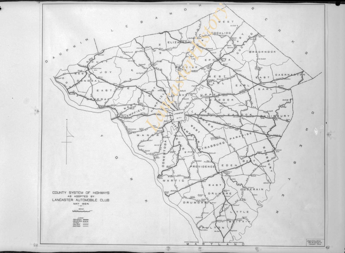
Photograph- Map showing county system of highways as adopted by the Lancaster Automobile Club, May 1924.
Object ID
D-07-03-51
Date Range
1924/05/19
More detail
1 image
Object Name
Negative
Collection
Darmstaetter Collection
Title
Photograph- Map showing county system of highways as adopted by the Lancaster Automobile Club, May 1924.
Description
Map showing county system of highways as adopted by the Lancaster Automobile Club, May 1924. 1 print only
Date Range
1924/05/19
Year Range From
1924
Storage Location
LancasterHistory, Lancaster, PA
Studio
Darmstaetter's
Subcategory
Documentary Artifact
Classification
Maps
Place
Lancaster County
Object Name
Negative
Film Size
6.5 x 5 inches
Object ID
D-07-03-51
Negative Number
yes
Other Number
613-1493
Images
Less detail
More Like This
Permalink
Toggle Full Record
Negative
https://collections.lancasterhistory.org/en/permalink/b8877825-0ed6-4461-a4da-234099163642
Collection
Darmstaetter Collection
Title
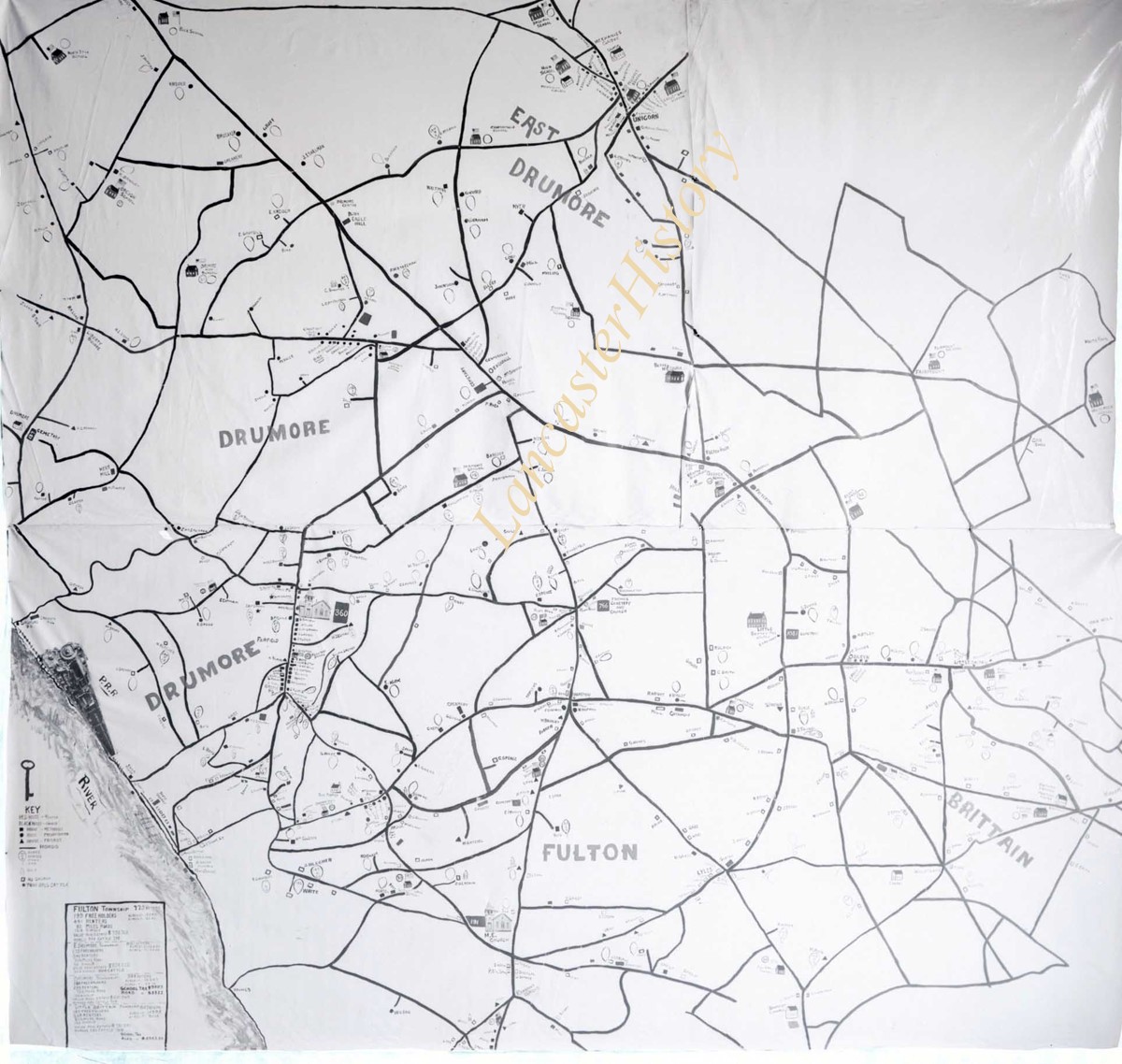
Photograph- Map showing Fulton and Drumore Townships.
Object ID
D-07-03-48
Date Range
1924/07/21
More detail
1 image
Object Name
Negative
Collection
Darmstaetter Collection
Title
Photograph- Map showing Fulton and Drumore Townships.
Description
Map showing Fulton and Drumore Townships. 1 print only
Date Range
1924/07/21
Year Range From
1924
Storage Location
LancasterHistory, Lancaster, PA
Studio
Darmstaetter's
Subcategory
Documentary Artifact
Classification
Maps
Object Name
Negative
Film Size
11 x 7 inches
Object ID
D-07-03-48
Negative Number
yes
Other Number
614-1666
Images
Less detail
More Like This
Permalink
Toggle Full Record
Negative
https://collections.lancasterhistory.org/en/permalink/c0c4524c-e47b-45e7-a502-752110992490
Collection
Darmstaetter Collection
Title
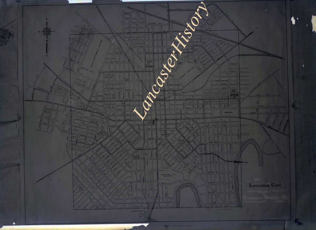
Photograph- Map of Lancaster city.
Object ID
D-07-03-45
Date Range
1926/04/05
More detail
1 image
Object Name
Negative
Collection
Darmstaetter Collection
Title
Photograph- Map of Lancaster city.
Description
Map of Lancaster city. 1 print only
Date Range
1926/04/05
Year Range From
1926
Storage Location
LancasterHistory, Lancaster, PA
Studio
Darmstaetter's
Subcategory
Documentary Artifact
Classification
Maps
Place
Lancaster
Object Name
Negative
Film Size
7 x 5 inches
Object ID
D-07-03-45
Negative Number
yes
Other Number
644-559
Images
Less detail
More Like This
Permalink
Toggle Full Record
Negative
https://collections.lancasterhistory.org/en/permalink/67176b5c-0f6f-47ca-82c2-793619095718
Collection
Darmstaetter Collection
Title
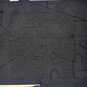
Photograph- Hand drawn map of various lots.
Object ID
D-07-03-35
Date Range
1928/12/24
More detail
1 image
Object Name
Negative
Collection
Darmstaetter Collection
Title
Photograph- Hand drawn map of various lots.
Description
Hand drawn map of various lots. 1 print only
Date Range
1928/12/24
Year Range From
1928
Storage Location
LancasterHistory, Lancaster, PA
Studio
Darmstaetter's
Subcategory
Documentary Artifact
Classification
Maps
Object Name
Negative
Film Size
10 x 8 inches
Object ID
D-07-03-35
Negative Number
yes
Other Number
690-1264
Images
Less detail
More Like This
Permalink
Toggle Full Record
Negative
https://collections.lancasterhistory.org/en/permalink/15efdc10-0658-4405-8d46-586411104702
Collection
Darmstaetter Collection
Title
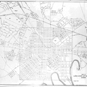
Photograph- Map of Lancaster city and vicinity.
Object ID
D-07-03-34
Date Range
1929/03/11
More detail
1 image
Object Name
Negative
Collection
Darmstaetter Collection
Title
Photograph- Map of Lancaster city and vicinity.
Description
Map of Lancaster city and vicinity. 1 print only
Date Range
1929/03/11
Year Range From
1929
Storage Location
LancasterHistory, Lancaster, PA
Studio
Darmstaetter's
Subcategory
Documentary Artifact
Classification
Maps
Place
Lancaster
Object Name
Negative
Film Size
10 x 8 inches
Object ID
D-07-03-34
Negative Number
yes
Other Number
690-229
Images
Less detail
More Like This
Permalink
Toggle Full Record
Negative
https://collections.lancasterhistory.org/en/permalink/41cb9348-089b-4130-82ef-998020663042
Collection
Darmstaetter Collection
Title
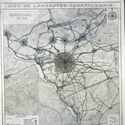
Photograph- Map of City of Lancaster Regional Plan.
Object ID
D-07-03-33
Date Range
1929/04/22
More detail
1 image
Object Name
Negative
Collection
Darmstaetter Collection
Title
Photograph- Map of City of Lancaster Regional Plan.
Description
Map of City of Lancaster Regional Plan. 1 print only
Date Range
1929/04/22
Year Range From
1929
Storage Location
LancasterHistory, Lancaster, PA
Studio
Darmstaetter's
Subcategory
Documentary Artifact
Classification
Maps
Place
Lancaster
Object Name
Negative
Film Size
8 x 10 inches
Object ID
D-07-03-33
Negative Number
yes
Other Number
690-395
Images
Less detail
More Like This
Permalink
Toggle Full Record
Negative
https://collections.lancasterhistory.org/en/permalink/44508b45-c915-47c8-86b8-191104915421
Collection
Darmstaetter Collection
Title
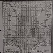
Photograph- Map--Probable extent of Commercial District.
Object ID
D-07-03-32
Date Range
1927/12/19
More detail
1 image
Object Name
Negative
Collection
Darmstaetter Collection
Title
Photograph- Map--Probable extent of Commercial District.
Description
Map--Probable extent of Commercial District. 1 print only
Date Range
1927/12/19
Year Range From
1927
Storage Location
LancasterHistory, Lancaster, PA
Studio
Darmstaetter's
Subcategory
Documentary Artifact
Classification
Maps
Place
Lancaster
Object Name
Negative
Film Size
8 x 10 inches
Object ID
D-07-03-32
Negative Number
yes
Other Number
670-472
Images
Less detail
More Like This
Permalink
10 records – page 1 of 1.
Prev
Next