Skip header and navigation

Revise Search

5 records – page 1 of 1.

Map showing location and date of the earliest highways leading from the Delaware and Schulkill Rivers to the Susquehanna River and it's branches / by H. Frank Eshleman

https://collections.lancasterhistory.org/en/permalink/lhdo15534
Author
Eshleman, H. Frank
Date of Publication
1907.
Call Number
974.815 SEPA 100
  1 document  
Author
Eshleman, H. Frank
Place of Publication
Lancaster, Pa
Publisher
H. Frank Eshleman,
Date of Publication
1907.
Physical Description
1 map ; 22 x 41 cm.
Notes
Scale on map [ca. 1:418,176]. 3/4 in. = 5 mi.
May be a reduced reproduction of the original map.
Subjects
Roads - Pennsylvania - Lancaster County - Maps.
Roads - Pennsylvania - Chester County - Maps.
Roads - Pennsylvania - Delaware County - Maps.
Lancaster County (Pa.) - Maps.
Chester County (Pa.) - Maps.
Delaware County (Pa.) - Maps.
Location
Lancaster History Library - Map
Call Number
974.815 SEPA 100
Documents

map_974.815_SEPA_100_.pdf

Read PDF Download PDF
Less detail

Map of Lancaster County, Pa. showing lines of Conestoga Traction Company

https://collections.lancasterhistory.org/en/permalink/lhdo15838
Corporate Author
Conestoga Traction Company.
Date of Publication
1909.
Call Number
974.815 LACO 141
  1 document  
Responsibility
courtesy, Conestoga Traction Company.
Corporate Author
Conestoga Traction Company.
Place of Publication
[Lititz, Pa
Publisher
Express Printing Co.,],
Date of Publication
1909.
Physical Description
1 map ; 23 x 27 cm.
Notes
Scale on map: 1 in. = 4.61 miles.
"Supplement of the Pennsylvania German, August, 1909."
"Figures give population of townships."
Reduced reprinting of original map.
Subjects
Conestoga Traction Company.
Electric railroads - Pennsylvania - Lancaster County - Maps.
Lancaster County (Pa.) - Population - Maps.
Lancaster County (Pa.) - Maps.
Location
Lancaster History Library - Map
Call Number
974.815 LACO 141
Documents

map_974.815_LACO_141_.pdf

Read PDF Download PDF
Less detail

Scott's map of Lancaster County : State of Pennsylvania, 1860

https://collections.lancasterhistory.org/en/permalink/lhdo11390
Date of Publication
1860.
Call Number
974.815 LACO 522
Responsibility
from actual measurements by Joshua Scott, C.E.
Place of Publication
Phila
Publisher
James D. Scott ,
Date of Publication
1860.
Physical Description
1 map on 4 sheets : digital photograph ; 67 x 75 cm.
Notes
Insets: Residence of John H. Breneman, Mount Joy (ill.)--Cedar Hill Female Seminary (ill.)--Church parsonage and seminaries at Lititz (ill.)--Mount Joy Steam Mills (ill.)--Mount Joy Academy (ill.)--Lancaster County Normal School (Millersville) (ill.)--Borough of Manheim (map)--Bainbridge (map)--Washington Institute,Columbia (ill.)--Borough of Strasburg (map)--Lititz (map)--Business cards of subscri bers in Lancaster City--LititzSprings Hotel (ill.)--Borough of Mount Joy (map)--Lancaster Court House (ill.)--Mount Joy Car Manufactory (ill.)--Business Cards of Subscribers in Columbia--cards of Marietta subscribers--Residence of B.M. Greider, Mount Joy.
Relief shown by hill shading.
Original housed in LCHS Archives.
Subjects
Lancaster County (Pa.) - Maps.
Location
Lancaster History Library - Map
Call Number
974.815 LACO 522
Less detail

The great Conestoga road

https://collections.lancasterhistory.org/en/permalink/lhdo7966
Author
Eshleman, Henry Frank,
Date of Publication
1908
Material: Book Subject(s): Conestoga Turnpike (Pa.)--History. Roads--Pennsylvania--Lancaster County. 
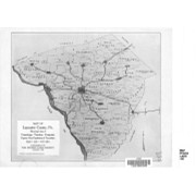
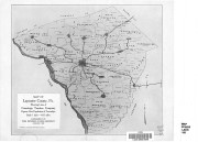
Lancaster County (Pa.)--Maps. Lancaster County (Pa.)--History--17th century. Publisher: Lancaster, Pa. : Lancaster County Historical Society, 1908 Description: [215]-232 p. : ill. ; 23 cm. Series: Journal
  1 document  
Responsibility
by H. Frank Eshleman, Esq.
Author
Eshleman, Henry Frank,
Place of Publication
Lancaster, Pa
Publisher
Lancaster County Historical Society,
Date of Publication
1908
Physical Description
[215]-232 p. : ill. ; 23 cm.
Series
Journal of the Lancaster County Historical Society ; v. 12, no. 6
Subjects
Conestoga Turnpike (Pa.)
Roads - Pennsylvania - Lancaster County.
Lancaster County (Pa.) - Maps.
Lancaster County (Pa.) - History - 17th century.
Contained In
Journal of the Lancaster County Historical Society. Volume 12, number 6 (1908), p. 215-232Lancaster History Library - Journal974.9 L245 v.12
Documents

vol12no6pp215_232_471436.pdf

Read PDF Download PDF
Less detail

Bridgens' atlas of Lancaster Co., Penna

https://collections.lancasterhistory.org/en/permalink/lhdo9531
Author
Bridgens, H. F.
Date of Publication
1864.
Call Number
LC912.74815 B851
  1 website  
Responsibility
From actual surveys by H. F. Bridgens and assistant.
Author
Bridgens, H. F.
Place of Publication
Philadelphia
Publisher
H. F. Bridgens,
Date of Publication
1864.
Physical Description
43 p. : maps, illus. ; 40 cm.
Notes
Contains map for each township. Property owners and landmarks are noted.
Kept on top of counter-height shelving unit.
Separate index.
Subjects
Real property - Pennsylvania - Lancaster County - Maps.
Lancaster County (Pa.) - Maps.
Location
Lancaster History Library - Reference
Call Number
LC912.74815 B851
Websites
Less detail