It appears no script is enabled within your browser. Please enable JavaScript to use this site.
Skip header and navigation
Toggle navigation
Collections
Search
Help
Privacy
Your Selections:
0
Items
Staff Login
Revise Search
Revise Search
Revise search
Search
Data Source
Photographs
3164
Artifacts
1
×
Data Source
All
A
B
C
D
E
F
G
H
I
J
K
L
M
N
O
P
Q
R
S
T
U
V
W
X
Y
Z
Sort
By Count
Alphabetical
Filtered by
Filter
Loading...
Collection
General Collection
983
Sarah Ann Stauffer Photograph Collection
340
Album 82 Donald A. Groff Photograph Album
180
John D. Denney, Jr. Photograph Collection
137
William Byron Hornberger Photograph Collection
127
Mildred Shopf Smiley Photograph Collection
118
Lancaster 250 Collection
117
Lancaster City and County Scenes Album
102
Harold Morrin Photograph Collection
98
Slaymaker Family Photograph Collection
98
Wails Family Photograph Collection
78
Bruce Ryder Photograph Collection
77
More
×
Collection
All
A
B
C
D
E
F
G
H
I
J
K
L
M
N
O
P
Q
R
S
T
U
V
W
X
Y
Z
Sort
By Count
Alphabetical
Filtered by
Filter
Loading...
Subject
Documentary Artifact
2453
Photographs
510
Military
464
World War II
448
United States Army
194
Pennsylvania National Guard
166
Portraits
144
Children
133
Cabinet cards
126
Women
102
James Buchanan Presidential Library
73
Uniforms
69
More
×
Subject
All
A
B
C
D
E
F
G
H
I
J
K
L
M
N
O
P
Q
R
S
T
U
V
W
X
Y
Z
Sort
By Count
Alphabetical
Filtered by
Filter
Loading...
Name
Thomas Studio
86
Hornberger, William Byron
71
Lease, Ammon M.
38
Gill's City Gallery
35
Hornberger, William Buch
34
Thomas, C. James
27
Rote, Jacob E.
26
Hornberger, Charlotte Naomi Weaver
24
Saylor, B. Frank
24
Barr, Doris Jane Hall
22
Ryder, Bruce
22
Darmstaetter's
21
More
×
Name
All
A
B
C
D
E
F
G
H
I
J
K
L
M
N
O
P
Q
R
S
T
U
V
W
X
Y
Z
Sort
By Count
Alphabetical
Filtered by
Filter
Loading...
Place
Lancaster
755
Lancaster Twp.
77
Lititz
70
Manheim Twp.
55
Columbia
47
East Hempfield Twp.
43
Pequea Twp.
35
Fort Stewart, Georgia
28
West Lampeter Twp.
28
Manor Twp.
27
Millersville
27
Newport News, Virginia
23
More
×
Place
All
A
B
C
D
E
F
G
H
I
J
K
L
M
N
O
P
Q
R
S
T
U
V
W
X
Y
Z
Sort
By Count
Alphabetical
Filtered by
Filter
Loading...
Decade
1020s
1
1070s
1
1190s
4
1740s
1
1800s
3
1810s
1
1820s
1
1840s
4
1850s
40
1860s
384
1870s
402
1880s
260
1890s
1900s
1347
1910s
2003
1920s
4749
1930s
3628
1940s
1950s
2387
1960s
1609
1970s
3855
1980s
1933
1990s
2989
2000s
2049
2010s
14
×
Decade
All
A
B
C
D
E
F
G
H
I
J
K
L
M
N
O
P
Q
R
S
T
U
V
W
X
Y
Z
Sort
By Count
Alphabetical
Filtered by
Filter
Loading...
Material
Print, Photographic
Transparency, Lantern Slide
584
Negative
30
Postcard
24
Print
9
Tintype
7
Negative, Glass Plate
5
Transparency, Slide
2
Archive
1
Envelope
1
Pamphlet
1
×
Material
All
A
B
C
D
E
F
G
H
I
J
K
L
M
N
O
P
Q
R
S
T
U
V
W
X
Y
Z
Sort
By Count
Alphabetical
Filtered by
Filter
Loading...
Online Media
Image
×
Online Media
All
A
B
C
D
E
F
G
H
I
J
K
L
M
N
O
P
Q
R
S
T
U
V
W
X
Y
Z
Sort
By Count
Alphabetical
Filtered by
Filter
Loading...
Advanced Search
Help
more like: 88E60301-2D49-45FE-A786-334577180848
1890s
1940s
Print, Photographic
Image
Sorted by
Relevance
Sort by Title
Expand All
Collapse All
List View
Gallery View
Print
10 records – page 1 of 1.
Prev
Next
Toggle Full Record
Print, Photographic
https://collections.lancasterhistory.org/en/permalink/78097c3c-174e-4450-8b8e-294486519984
Collection
General Collection
Object ID
2-07-05-25
Date Range
c. 1943
More detail
1 image
Object Name
Print, Photographic
Collection
General Collection
Description
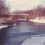
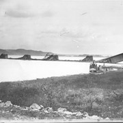
Bridge connected to the Rote Farm, known as Old Factory Bridge, South Duke Street Bridge and Rockland Cotton Mill Bridge.
Date Range
c. 1943
Storage Location
LancasterHistory, Lancaster, PA
Subcategory
Documentary Artifact
Search Terms
Rockland Cotton Mill Bridge
Old Factory Bridge
South Duke Street Bridge
Conestoga River
Covered bridges
Place
Lancaster
Object Name
Print, Photographic
Print Size
10 x 8 inches
Object ID
2-07-05-25
Images
Less detail
More Like This
Permalink
Toggle Full Record
Print, Photographic
https://collections.lancasterhistory.org/en/permalink/baa2689f-cd3e-442d-9cfc-197138066525
Collection
General Collection
Title
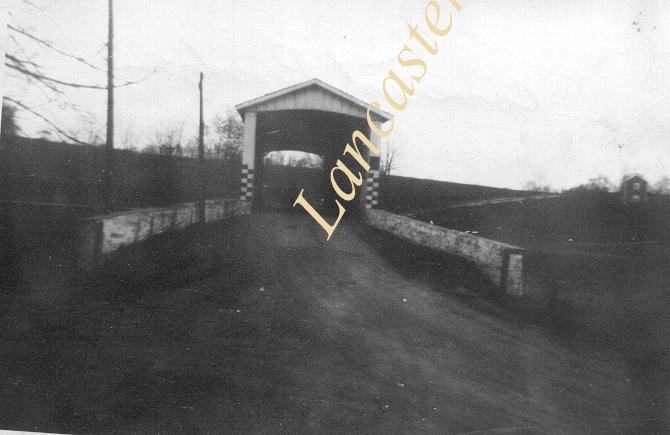
Photograph- Covered bridge over Chiques Creek above Sentz's Mill.
Object ID
1-03-02-85
Date Range
1946
More detail
1 image
Object Name
Print, Photographic
Collection
General Collection
Title
Photograph- Covered bridge over Chiques Creek above Sentz's Mill.
Description
Covered bridge over Chiques Creek above Sentz's Mill.
Date Range
1946
Storage Location
LancasterHistory, Lancaster, PA
Subcategory
Documentary Artifact
Search Terms
Bridges
Covered Bridges
Mills
Chiques Creek
Chickies Creek
Object Name
Print, Photographic
Print Size
5 x 3.5 inches
Object ID
1-03-02-85
Images
Less detail
More Like This
Permalink
Toggle Full Record
Print, Photographic
https://collections.lancasterhistory.org/en/permalink/2e983a02-7256-4a1f-8f86-263831243090
Collection
Lancaster City and County Scenes Album
Object ID
A-34-01-45
More detail
1 image
Object Name
Print, Photographic
Collection
Lancaster City and County Scenes Album
Description
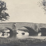
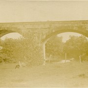
Stone arch bridge across the Octoraro Creek. Note cows wading in the water.
Year Range From
1898
Year Range To
1905
Storage Location
LancasterHistory, Lancaster, PA
Subcategory
Documentary Artifact
Search Terms
Bridges
Stone arch bridges
Octoraro Creek
Cows
Object Name
Print, Photographic
Print Size
5 x 7 inches
Object ID
A-34-01-45
Images
Less detail
More Like This
Permalink
Toggle Full Record
Print, Photographic
https://collections.lancasterhistory.org/en/permalink/1a1d6000-fdc2-4d39-acd2-216153660729
Collection
General Collection
Object ID
2-07-05-05
Date Range
1896
More detail
1 image
Object Name
Print, Photographic
Collection
General Collection
Description
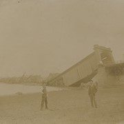
Columbia - Wrightsville Bridge bridge after the hurricane blew it down
Date Range
1896
Storage Location
LancasterHistory, Lancaster, PA
Subcategory
Documentary Artifact
Search Terms
Columbia - Wrightsville Bridge
Covered bridges
Hurricanes
Susquehanna River
Ferries
Place
Columbia
Object Name
Print, Photographic
Object ID
2-07-05-05
Images
Less detail
More Like This
Permalink
Toggle Full Record
Print, Photographic
https://collections.lancasterhistory.org/en/permalink/6ee7232d-3230-48c3-a3e7-546648617306
Collection
General Collection
Object ID
2-04-01-37
Date Range
August 14, 1894
More detail
1 image
Object Name
Print, Photographic
Collection
General Collection
Description
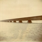
Columbia Bridge
Date Range
August 14, 1894
Storage Location
LancasterHistory, Lancaster, PA
Subcategory
Documentary Artifact
Search Terms
Columbia - Wrightsville Bridge
Susquehanna River
Covered bridges
Place
Columbia
Object Name
Print, Photographic
Print Size
4.75 x 3.75 inches
Object ID
2-04-01-37
Images
Less detail
More Like This
Permalink
Toggle Full Record
Print, Photographic
https://collections.lancasterhistory.org/en/permalink/a4351179-7daf-4833-a8c8-034855414555
Collection
General Collection
Object ID
2-19-04-14
Date Range
September 24, 1894
More detail
1 image
Object Name
Print, Photographic
Collection
General Collection
Description
Columbia Bridge blown down September 24, 1894.
Date Range
September 24, 1894
Storage Location
LancasterHistory, Lancaster, PA
Subcategory
Documentary Artifact
Search Terms
Columbia - Wrightsville Bridge
Wagons
Covered bridges
Object Name
Print, Photographic
Print Size
8.25 x 7.25 inches
Condition
Good
Object ID
2-19-04-14
Images
Less detail
More Like This
Permalink
Toggle Full Record
Print, Photographic
https://collections.lancasterhistory.org/en/permalink/38e5b00f-b8ca-490d-b669-856974464050
Collection
General Collection
Object ID
2-04-03-16
Date Range
May 25, 1899
More detail
1 image
Object Name
Print, Photographic
Collection
General Collection
Description
Along Chiques Creek
Date Range
May 25, 1899
Storage Location
LancasterHistory, Lancaster, PA
Subcategory
Documentary Artifact
Search Terms
Chiques Creek
Creeks
Bridges
Chickies Creek
Place
West Hempfield Twp.
Object Name
Print, Photographic
Print Size
9 x 7 inches
Object ID
2-04-03-16
Images
Less detail
More Like This
Permalink
Toggle Full Record
Print, Photographic
https://collections.lancasterhistory.org/en/permalink/d613e041-ac15-4cf3-a27c-835327313140
Collection
General Collection
Title
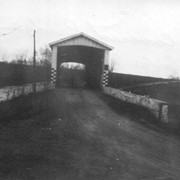
Photograph- Bridge between Ephrata and Reamstown looking from Route 222
Object ID
1-05-03-48
Date Range
April 1948
More detail
1 image
Object Name
Print, Photographic
Collection
General Collection
Title
Photograph- Bridge between Ephrata and Reamstown looking from Route 222
Description
Bridge between Ephrata and Reamstown looking from Route 222
Date Range
April 1948
Storage Location
LancasterHistory, Lancaster, PA
Subcategory
Documentary Artifact
Search Terms
Bridges
Covered bridges
Reamstown, East Cocalico Twp.
Place
East Cocalico Twp.
Object Name
Print, Photographic
Object ID
1-05-03-48
Images
Less detail
More Like This
Permalink
Toggle Full Record
Print, Photographic
https://collections.lancasterhistory.org/en/permalink/4812ea9e-edd1-48c8-b992-939493122124
Collection
General Collection
Object ID
2-04-03-18
Date Range
August 21, 1894
More detail
1 image
Object Name
Print, Photographic
Collection
General Collection
Description
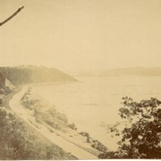
View from Chickies Rock showing Susquehanna River and canal.
Date Range
August 21, 1894
Storage Location
LancasterHistory, Lancaster, PA
Subcategory
Documentary Artifact
Search Terms
Chickies Rock
West Hempfield Twp.
Canals
Place
West Hempfield Twp.
Object Name
Print, Photographic
Print Size
6.5 x 5.5 inches
Object ID
2-04-03-18
Images
Less detail
More Like This
Permalink
Toggle Full Record
Print, Photographic
https://collections.lancasterhistory.org/en/permalink/e28f7f7e-bcca-4092-95fa-430066457522
Collection
Lancaster City and County Scenes Album
Object ID
A-34-01-04
More detail
1 image
Object Name
Print, Photographic
Collection
Lancaster City and County Scenes Album
Description
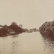
The Conestoga River below Witmer's Bridge. Bridge and Lady Gay paddleboat are in background.
Year Range From
1898
Year Range To
1905
Storage Location
LancasterHistory, Lancaster, PA
Subcategory
Documentary Artifact
Search Terms
Boats
Bridges
Stone arch bridges
Witmer's Bridge
Conestoga River
Place
Lancaster
Object Name
Print, Photographic
Print Size
3 x 3 inches
Object ID
A-34-01-04
Images
Less detail
More Like This
Permalink
10 records – page 1 of 1.
Prev
Next