It appears no script is enabled within your browser. Please enable JavaScript to use this site.
Skip header and navigation
Toggle navigation
Collections
Search
Help
Privacy
Your Selections:
0
Items
Staff Login
Revise Search
Revise Search
Revise search
Search
Data Source
Library
7
×
Data Source
All
A
B
C
D
E
F
G
H
I
J
K
L
M
N
O
P
Q
R
S
T
U
V
W
X
Y
Z
Sort
By Count
Alphabetical
Filtered by
Filter
Loading...
Subject
Lancaster County (Pa.) - Maps.
Roads - Pennsylvania - Lancaster County - Maps.
5
Lancaster (Pa.) - Maps.
3
Bicycle trails - Pennsylvania - Lancaster County - Maps.
2
Elizabethtown (Pa.) - Maps.
2
Heritage tourism - Pennsylvania - Lancaster County - Maps.
2
Zip codes - Pennsylvania - Lancaster County - Maps.
2
Bicycle stores - Pennsylvania - Lancaster County - Maps.
1
Bicycle trails - Pennsylvania - Lancaster - Maps.
1
Bus lines - Pennsylvania - Lancaster - Maps.
1
Bus lines - Pennsylvania - Lancaster County - Maps.
1
Cemeteries - Pennsylvania - Lancaster
1
More
×
Subject
All
A
B
C
D
E
F
G
H
I
J
K
L
M
N
O
P
Q
R
S
T
U
V
W
X
Y
Z
Sort
By Count
Alphabetical
Filtered by
Filter
Loading...
Name
ADC (Firm)
3
Conestoga Traction Company.
1
Eshleman, H. Frank
1
Lancaster County Planning Commission.
1
Peter Volz Design (Firm)
1
Steve Spindler Cartography (Firm)
1
Toole Design Group.
1
×
Name
All
A
B
C
D
E
F
G
H
I
J
K
L
M
N
O
P
Q
R
S
T
U
V
W
X
Y
Z
Sort
By Count
Alphabetical
Filtered by
Filter
Loading...
Decade
1820s
2
1890s
2
1900s
1910s
1
1920s
3
1930s
3
1940s
1
1950s
5
1960s
15
1970s
10
1980s
7
1990s
5
2000s
×
Decade
All
A
B
C
D
E
F
G
H
I
J
K
L
M
N
O
P
Q
R
S
T
U
V
W
X
Y
Z
Sort
By Count
Alphabetical
Filtered by
Filter
Loading...
Material
Cartographic
Text
2
×
Material
All
A
B
C
D
E
F
G
H
I
J
K
L
M
N
O
P
Q
R
S
T
U
V
W
X
Y
Z
Sort
By Count
Alphabetical
Filtered by
Filter
Loading...
Online Media
PDF
2
×
Online Media
All
A
B
C
D
E
F
G
H
I
J
K
L
M
N
O
P
Q
R
S
T
U
V
W
X
Y
Z
Sort
By Count
Alphabetical
Filtered by
Filter
Loading...
Advanced Search
Help
more like: A24A4172-22BA-49EA-9F71-877043627460
1900s
2000s
Cartographic
Lancaster County (Pa.) - Maps.
Sorted by
Relevance
Sort by Title
Expand All
Collapse All
List View
Gallery View
Print
7 records – page 1 of 1.
Prev
Next
Toggle Full Record
Lancaster County bicycle map
https://collections.lancasterhistory.org/en/permalink/lhdo15535
Date of Publication
2004.
Call Number
974.815 LACO 523
More detail
Responsibility
Steve Spindler Cartography ; Peter Volz Design ; Toole Design Group.
Place of Publication
[S.l.]
Publisher
Toole Design Group,
Date of Publication
2004.
Physical Description
3 maps on 1 sheet : both sides, col. ill. ; 63 x 67 cm. or smaller, on sheet 63 x 76 cm., folded to 22 x 20 cm.
Notes
"December 2004"--Verso.
"Map produced for Lancaster County, Pennsylvania."
Relief shown in shading.
Includes text, illustrations, table of travel time/distance.
Contents
On verso: City of Lancaster -- Transit map: Lancaster city routes - county routes.
Text. Recto: Bicycle tours of Lancaster County. Verso: Loading your bike onto the bus -- Bike shops and clubs -- Bicycle safety tips.
Subjects
Bicycle trails - Pennsylvania - Lancaster County - Maps.
Cycling - Pennsylvania - Lancaster County - Maps.
Roads - Pennsylvania - Lancaster County - Maps.
Lancaster County (Pa.) - Maps.
Lancaster County (Pa.) - Distances - Maps.
Additional Corporate Author
Steve Spindler Cartography (Firm)
Peter Volz Design (Firm)
Toole Design Group.
Lancaster County Planning Commission.
Location
Lancaster History Library - Map
Call Number
974.815 LACO 523
Less detail
More Like This
Permalink
Toggle Full Record
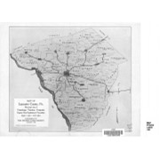
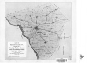
Map of Lancaster County, Pa. showing lines of Conestoga Traction Company
https://collections.lancasterhistory.org/en/permalink/lhdo15838
Corporate Author
Conestoga Traction Company.
Date of Publication
1909.
Call Number
974.815 LACO 141
More detail
1 document
Responsibility
courtesy, Conestoga Traction Company.
Corporate Author
Conestoga Traction Company.
Place of Publication
[Lititz, Pa
Publisher
Express Printing Co.,],
Date of Publication
1909.
Physical Description
1 map ; 23 x 27 cm.
Notes
Scale on map: 1 in. = 4.61 miles.
"Supplement of the Pennsylvania German, August, 1909."
"Figures give population of townships."
Reduced reprinting of original map.
Subjects
Conestoga Traction Company.
Electric railroads - Pennsylvania - Lancaster County - Maps.
Lancaster County (Pa.) - Population - Maps.
Lancaster County (Pa.) - Maps.
Location
Lancaster History Library - Map
Call Number
974.815 LACO 141
Documents
map_974.815_LACO_141_.pdf
Read PDF
Download PDF
Less detail
More Like This
Permalink
Toggle Full Record
Elizabethtown ; Lancaster County
https://collections.lancasterhistory.org/en/permalink/lhdo15532
Edition
2005 ed.
Date of Publication
2005.
Call Number
974.815 ELIZ 100
More detail
Alternate Title
City of Elizabethtown & Lancaster County
City of Elizabethtown and Lancaster County
Lancaster County
Edition
2005 ed.
Place of Publication
[S.l
Publisher
Hometown Productions],
Date of Publication
2005.
Physical Description
2 maps on 1 sheet : both sides ; 56 x 88 cm. and 56 x 87 cm. on sheet 58 x 89 cm., folded to 11 x 23 cm.
Notes
Panel title.
Includes location map and advertisements.
Elizabethtown map includes index to streets.
Contents
Elizabethtown -- Lancaster County.
Subjects
Roads - Pennsylvania - Elizabethtown - Maps.
Roads - Pennsylvania - Lancaster County - Maps.
Elizabethtown (Pa.) - Maps.
Lancaster County (Pa.) - Maps.
Location
Lancaster History Library - Map
Call Number
974.815 ELIZ 100
Less detail
More Like This
Permalink
Toggle Full Record
Map showing location and date of the earliest highways leading from the Delaware and Schulkill Rivers to the Susquehanna River and it's branches / by H. Frank Eshleman
https://collections.lancasterhistory.org/en/permalink/lhdo15534
Author
Eshleman, H. Frank
Date of Publication
1907.
Call Number
974.815 SEPA 100
More detail
1 document
Author
Eshleman, H. Frank
Place of Publication
Lancaster, Pa
Publisher
H. Frank Eshleman,
Date of Publication
1907.
Physical Description
1 map ; 22 x 41 cm.
Notes
Scale on map [ca. 1:418,176]. 3/4 in. = 5 mi.
May be a reduced reproduction of the original map.
Subjects
Roads - Pennsylvania - Lancaster County - Maps.
Roads - Pennsylvania - Chester County - Maps.
Roads - Pennsylvania - Delaware County - Maps.
Lancaster County (Pa.) - Maps.
Chester County (Pa.) - Maps.
Delaware County (Pa.) - Maps.
Location
Lancaster History Library - Map
Call Number
974.815 SEPA 100
Documents
map_974.815_SEPA_100_.pdf
Read PDF
Download PDF
Less detail
More Like This
Permalink
Toggle Full Record
Lancaster County, Pennsylvania street map book
https://collections.lancasterhistory.org/en/permalink/lhdo12583
Corporate Author
ADC (Firm)
Edition
11th ed.
Date of Publication
c2001.
Call Number
917.4185 A221 11th ed. reference desk
More detail
Responsibility
ADC.
ISBN
0875300863
Corporate Author
ADC (Firm)
Edition
11th ed.
Place of Publication
Alexandria, Va
Publisher
ADC,
Date of Publication
c2001.
Physical Description
1 atlas (88 p.) : col. map ; 36 cm.
Notes
Cover title.
"ADC The Map People."
Includes indexes.
Subjects
Zip codes - Pennsylvania - Lancaster County - Maps.
Lancaster County (Pa.) - Maps.
Location
Lancaster History Library - Reference
Call Number
917.4185 A221 11th ed. reference desk
Less detail
More Like This
Permalink
Toggle Full Record
Lancaster County, Pennsylvania : street map book
https://collections.lancasterhistory.org/en/permalink/lhdo18989
Corporate Author
ADC (Firm)
Edition
13th ed.
Date of Publication
c2007.
Call Number
912.74815 A221 13th ed. 2007
More detail
Alternate Title
Street map book, Lancaster County, Pennsylvania
Responsibility
ADC.
ISBN
0875308384
9780875308388
Corporate Author
ADC (Firm)
Edition
13th ed.
Place of Publication
Alexandria, VA
Publisher
ADC,
Date of Publication
c2007.
Physical Description
1 atlas (124 p.) : col. map ; 32 cm.
Notes
Title from cover.
Includes indexes.
Subjects
Zip codes - Pennsylvania - Lancaster County - Maps.
Lancaster County (Pa.) - Maps.
Location
Lancaster History Library - Lancaster County
Lancaster History Library - Reference
Call Number
912.74815 A221 13th ed. 2007
Less detail
More Like This
Permalink
Toggle Full Record
Lancaster County, Pennsylvania, street map book : includes Akron, Denver, Mountville, East Petersburg ... and much more
https://collections.lancasterhistory.org/en/permalink/lhdo17746
Corporate Author
ADC (Firm)
Edition
12th ed.
Date of Publication
[c2005]
Call Number
912.74815 A221 12th ed. Oversize
912.74815 A221 12th ed. Landowner's Atlas Stand
More detail
Responsibility
ADC.
ISBN
0875306020
9780875306025
Corporate Author
ADC (Firm)
Edition
12th ed.
Place of Publication
Alexandria, VA
Publisher
ADC,
Date of Publication
[c2005]
Physical Description
1 atlas (124 p.) : col. map ; 32 cm.
Notes
Title from cover.
Includes indexes.
Subjects
Lancaster County (Pa.) - Maps.
Location
Lancaster History Library - Lancaster County
Lancaster History Library - Reference
Call Number
912.74815 A221 12th ed. Oversize
912.74815 A221 12th ed. Landowner's Atlas Stand
Less detail
More Like This
Permalink
7 records – page 1 of 1.
Prev
Next