Skip header and navigation

Revise Search

10 records – page 1 of 1.

Collection
General Collection
Object ID
1-09-03-85
Date Range
July 1956
  1 image  
Object Name
Print, Photographic
Collection
General Collection
Description
Binkley's Mill covered bridge across the Conestoga River at Eden, northeast of Lancaster.
Provenance
Lancaster County covered bridge photos taken by M. E. Schroll and Kathryn L. Sauder taken between 1956 and 1958.
Date Range
July 1956
Storage Location
LancasterHistory, Lancaster, PA
Subcategory
Documentary Artifact
Search Terms
Binkley's Mill
Covered bridges
Conestoga River
Eden, Manheim Twp.
Place
Manheim Twp.
Object Name
Print, Photographic
Print Size
3.5 x 3.5 inches
Condition
Good
Object ID
1-09-03-85
Images
Less detail
Collection
General Collection
Object ID
1-09-03-86
Date Range
August 6, 1958
  1 image  
Object Name
Print, Photographic
Collection
General Collection
Description
Binkley's Mill covered bridge on the Conestoga River at Eden.
Provenance
Lancaster County covered bridge photos taken by M. E. Schroll and Kathryn L. Sauder taken between 1956 and 1958.
Date Range
August 6, 1958
Storage Location
LancasterHistory, Lancaster, PA
Subcategory
Documentary Artifact
Search Terms
Binkley's Mill
Covered bridges
Conestoga River
Eden, Manheim Twp.
Place
Manheim Twp.
Object Name
Print, Photographic
Print Size
3.5 x 3.5 inches
Condition
Good
Object ID
1-09-03-86
Images
Less detail
Collection
General Collection
Title
Eden Bridge
Object ID
1-21-03-31
Date Range
31 October 1958
  1 image  
Object Name
Print, Photographic
Collection
General Collection
Title
Eden Bridge
Description
Eden bridge
Date Range
31 October 1958
Creator
Bond, George Ross
Storage Location
LancasterHistory, Lancaster, PA
Storage Room
Archives West
People
Bond, G. Ross
Subject
Photographs
Classification
1-21-03-31
Search Terms
Covered bridges
Eden, Manheim Twp.
Conestoga River
Place
Manheim Twp.
Object Name
Print, Photographic
Original or Copy
Original
Print Size
4 x 5 inches
Dimention Details
Photograph is glued to black paper
Object ID
1-21-03-31
Credit
Courtesy of LancasterHistory, Lancaster, Pennsylvania
Images
Less detail
Collection
General Collection
Object ID
1-09-03-83
Date Range
August 1958
  1 image  
Object Name
Print, Photographic
Collection
General Collection
Description
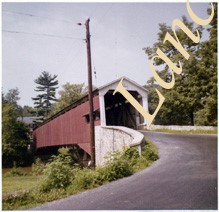
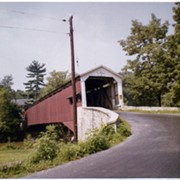
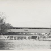
Hunsecker's Mill Bridge on the Conestoga River between Manheim and Upper Leacock townships. Destroyed by Hurricane Agnes, June 22, 1972 but rebuilt on the same site.
Provenance
Lancaster County covered bridge photos taken by M. E. Schroll and Kathryn L. Sauder taken between 1956 and 1958.
Date Range
August 1958
Storage Location
LancasterHistory, Lancaster, PA
Subcategory
Documentary Artifact
Search Terms
Hunsecker's Mill
Covered bridges
Conestoga River
Manheim Twp.
Upper Leacock Twp.
Object Name
Print, Photographic
Print Size
3.5 x 3.5 inches
Condition
Good
Object ID
1-09-03-83
Images
Less detail
Collection
General Collection
Object ID
1-09-03-87
Date Range
August 1956
  1 image  
Object Name
Print, Photographic
Collection
General Collection
Description
Wabank Mill Bridge, also called Third Lock Bridge, on the Conestoga River between Lancaster and Pequea townships.
Provenance
Lancaster County covered bridge photos taken by M. E. Schroll and Kathryn L. Sauder taken between 1956 and 1958.
Date Range
August 1956
Storage Location
LancasterHistory, Lancaster, PA
Subcategory
Documentary Artifact
Search Terms
Bridges
Conestoga River
Covered bridges
Creeks
Lancaster Twp.
Mills
Pequea Twp.
Third Lock Bridge
Wabank Mill
Wabank Mill Bridge
Object Name
Print, Photographic
Print Size
3.5 x 3.5 inches
Condition
Good
Object ID
1-09-03-87
Images
Less detail
Collection
General Collection
Object ID
1-09-03-88
Date Range
August 7, 1958
  1 image  
Object Name
Print, Photographic
Collection
General Collection
Description
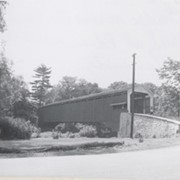
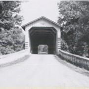
Wabank Mill bridge, also called Third Lock bridge, on the Conestoga River between Lancaster and Pequea townships. This bridge was replaced by a road relocation in 1958.
Provenance
Lancaster County covered bridge photos taken by M. E. Schroll and Kathryn L. Sauder taken between 1956 and 1958.
Date Range
August 7, 1958
Storage Location
LancasterHistory, Lancaster, PA
Subcategory
Documentary Artifact
Search Terms
Bridges
Conestoga River
Covered bridges
Creeks
Lancaster Twp.
Mills
Pequea Twp.
Third Lock Bridge
Wabank Mill
Wabank Mill Bridge
Object Name
Print, Photographic
Print Size
3.5 x 3.5 inches
Condition
Good
Object ID
1-09-03-88
Images
Less detail
Collection
General Collection
Title
Photograph- End view of Kurtz's Mill covered bridge across Big Conestoga, north of Fairmount.
Object ID
1-09-03-34
Date Range
August 1956
  1 image  
Object Name
Print, Photographic
Collection
General Collection
Title
Photograph- End view of Kurtz's Mill covered bridge across Big Conestoga, north of Fairmount.
Description
End view of Kurtz's Mill covered bridge across Big Conestoga.
Provenance
Lancaster County covered bridge photos taken by M. E. Schroll and Kathryn L. Sauder taken between 1956 and 1958.
Date Range
August 1956
Storage Location
LancasterHistory, Lancaster, PA
Subcategory
Documentary Artifact
Search Terms
Covered bridges
Conestoga River
Kurtz's Mill Covered Bridge
Martindale, Earl Twp.
Place
Earl Twp.
Object Name
Print, Photographic
Print Size
3.5 x 3.5 inches
Condition
Good
Object ID
1-09-03-34
Images
Less detail
Collection
Covered Bridge Album
Object ID
A-11-01-06
Date Range
1950
  1 image  
Object Name
Print, Photographic
Collection
Covered Bridge Album
Description
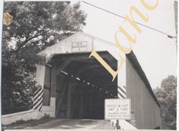
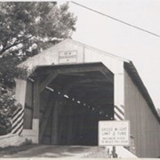
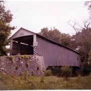
Bushong's Mill, near Oregon between Upper Leacock and Manheim Townships. State supervised on road LR 36009, built in 1843, longest single span in the county, 195 feet long.
Date Range
1950
Creator
Gaintner, Jay Richard
Storage Location
LancasterHistory, Lancaster, PA
Subcategory
Documentary Artifact
Search Terms
Bridges
Covered bridges
Oregon, Manheim Twp.
Mills
Conestoga River
Object Name
Print, Photographic
Print Size
8 x 10 inches
Object ID
A-11-01-06
Images
Less detail
Collection
General Collection
Object ID
1-09-03-79
Date Range
August 13, 1958
  1 image  
Object Name
Print, Photographic
Collection
General Collection
Description
Bitzer's Mill covered bridge, also called Eberly's Cider Mill covered bridge, on the Conestoga River north of Fairmount.
Provenance
Lancaster County covered bridge photos taken by M. E. Schroll and Kathryn L. Sauder taken between 1956 and 1958.
Date Range
August 13, 1958
Storage Location
LancasterHistory, Lancaster, PA
Subcategory
Documentary Artifact
Search Terms
Bitzer's Mill
Covered bridges
Eberly's Cider Mill
Conestoga River
Fairmount, West Earl Twp.
Place
West Earl Twp.
Object Name
Print, Photographic
Print Size
3.5 x 3.5 inches
Condition
Good
Object ID
1-09-03-79
Images
Less detail
Collection
General Collection
Object ID
1-09-03-80
Date Range
August 13, 1958
  1 image  
Object Name
Print, Photographic
Collection
General Collection
Description
Bitzer's Mill covered bridge, also called Eberly's Cider Mill covered bridge, on the Conestoga River north of Fairmount.
Provenance
Lancaster County covered bridge photos taken by M. E. Schroll and Kathryn L. Sauder taken between 1956 and 1958.
Date Range
August 13, 1958
Storage Location
LancasterHistory, Lancaster, PA
Subcategory
Documentary Artifact
Search Terms
Bitzer's Mill
Covered bridges
Eberly's Cider Mill
Conestoga River
Fairmount, West Earl Twp.
Place
West Earl Twp.
Object Name
Print, Photographic
Print Size
3.5 x 3.5 inches
Condition
Good
Object ID
1-09-03-80
Images
Less detail

10 records – page 1 of 1.