It appears no script is enabled within your browser. Please enable JavaScript to use this site.
Skip header and navigation
Toggle navigation
Collections
Search
Help
Privacy
Your Selections:
0
Items
Staff Login
Revise Search
Revise Search
Revise search
Search
Data Source
Photographs
6
Library
3
×
Data Source
All
A
B
C
D
E
F
G
H
I
J
K
L
M
N
O
P
Q
R
S
T
U
V
W
X
Y
Z
Sort
By Count
Alphabetical
Filtered by
Filter
Loading...
Collection
General Collection
6
×
Collection
All
A
B
C
D
E
F
G
H
I
J
K
L
M
N
O
P
Q
R
S
T
U
V
W
X
Y
Z
Sort
By Count
Alphabetical
Filtered by
Filter
Loading...
Subject
Covered bridges
6
Conestoga River
3
Martindale, Earl Twp.
2
Pequea Creek
2
Warrant maps
2
Beaver Creek
1
Colemanville Covered Bridge
1
Colemanville, Conestoga Twp.
1
Earl (Lancaster County, Pa. : Township) - Maps.
1
East Earl (Pa. : Township) - Maps.
1
Eden, Manheim Twp.
1
Land grants - Pennsylvania - Earl (Lancaster County, Pa.) : Township
1
More
×
Subject
All
A
B
C
D
E
F
G
H
I
J
K
L
M
N
O
P
Q
R
S
T
U
V
W
X
Y
Z
Sort
By Count
Alphabetical
Filtered by
Filter
Loading...
Name
Kurtz, Howard G. Sr.
6
Pennsylvania. Bureau of Land Records.
2
Pennsylvania Bureau of Land Records.
1
×
Name
All
A
B
C
D
E
F
G
H
I
J
K
L
M
N
O
P
Q
R
S
T
U
V
W
X
Y
Z
Sort
By Count
Alphabetical
Filtered by
Filter
Loading...
Place
Earl Twp.
2
Conestoga Twp.
1
Manheim Twp.
1
Paradise Twp.
1
Strasburg Twp.
1
×
Place
All
A
B
C
D
E
F
G
H
I
J
K
L
M
N
O
P
Q
R
S
T
U
V
W
X
Y
Z
Sort
By Count
Alphabetical
Filtered by
Filter
Loading...
Decade
1920s
6
1930s
1960s
4
1970s
96
1990s
74
×
Decade
All
A
B
C
D
E
F
G
H
I
J
K
L
M
N
O
P
Q
R
S
T
U
V
W
X
Y
Z
Sort
By Count
Alphabetical
Filtered by
Filter
Loading...
Material
Print, Photographic
58
Archive
27
Negative
Report
5
Cartographic
Text
2
Blueprint
1
Documents
1
Petition
1
Postcard
1
Scrapbook
1
×
Material
All
A
B
C
D
E
F
G
H
I
J
K
L
M
N
O
P
Q
R
S
T
U
V
W
X
Y
Z
Sort
By Count
Alphabetical
Filtered by
Filter
Loading...
Online Media
Image
6
×
Online Media
All
A
B
C
D
E
F
G
H
I
J
K
L
M
N
O
P
Q
R
S
T
U
V
W
X
Y
Z
Sort
By Count
Alphabetical
Filtered by
Filter
Loading...
Advanced Search
Help
more like: 4133C058-4B90-466A-8DE6-803348841358
1930s
Cartographic
Negative
Sorted by
Relevance
Sort by Title
Expand All
Collapse All
List View
Gallery View
Print
9 records – page 1 of 1.
Prev
Next
Toggle Full Record
Earl Township
https://collections.lancasterhistory.org/en/permalink/lhdo5203
Corporate Author
Pennsylvania Bureau of Land Records.
Date of Publication
1935.
Call Number
500 969
More detail
Corporate Author
Pennsylvania Bureau of Land Records.
Place of Publication
Harisburg, Pa
Publisher
Land Bureau ,
Date of Publication
1935.
Physical Description
1 map ; 75 x 47 cm.
Notes
112 Tracts.
Show warrants, surveys and patents compiled from records in the "Department of Internal Affairs of Pennsylvania".
Photocopy.
Date of situation: 1719-1787.
Subjects
Real property - Pennsylvania - Earl (Lancaster County, Pa. : Township)
Land grants - Pennsylvania - Earl (Lancaster County, Pa.) : Township
Earl (Lancaster County, Pa. : Township) - Maps.
Location
Lancaster History Library - Map
Call Number
500 969
Less detail
More Like This
Permalink
Toggle Full Record
Negative
https://collections.lancasterhistory.org/en/permalink/3db163ed-c386-447f-a4c0-529416180961
Collection
General Collection
Object ID
1-19-01-44
Date Range
c. 1930
More detail
1 image
Object Name
Negative
Collection
General Collection
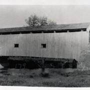
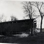
Description
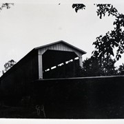
Covered bridge near Martindale, over the Conestoga River
Provenance
Transferred from the Bob Swartz Collection at the Lower Merion Historical Society, May 6, 2014.
Date Range
c. 1930
Creator
Kurtz, Howard G. Sr.
Storage Location
LancasterHistory, Lancaster, PA
Search Terms
Covered bridges
Martindale, Earl Twp.
Conestoga River
Place
Earl Twp.
Object Name
Negative
Film Size
3 x 4.75 inches
Object ID
1-19-01-44
Images
Less detail
More Like This
Permalink
Toggle Full Record
Negative
https://collections.lancasterhistory.org/en/permalink/efc799b5-dfac-49c0-8a94-162206464266
Collection
General Collection
Object ID
1-19-01-45
Date Range
c. 1930
More detail
1 image
Object Name
Negative
Collection
General Collection
Description
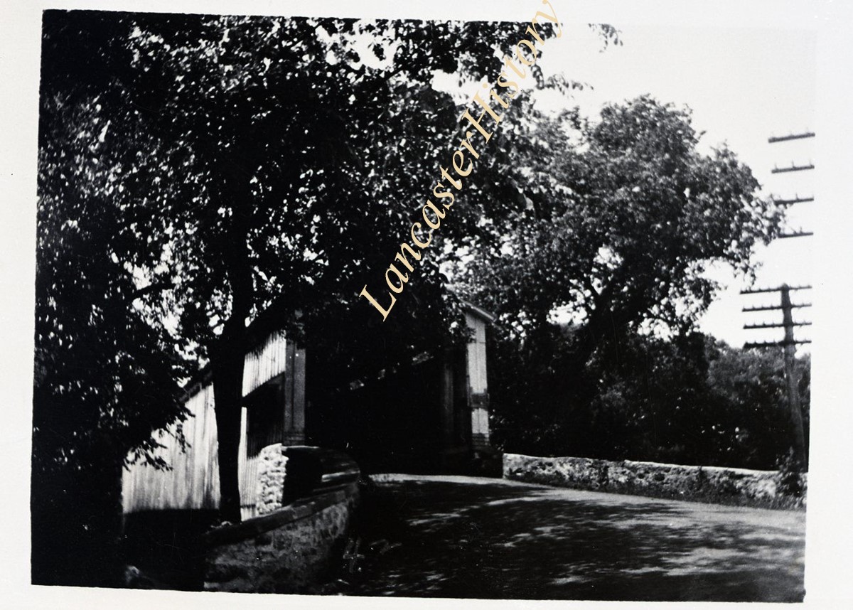
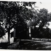
Covered bridge south of Martindale, over the Conestoga River
Provenance
Transferred from the Bob Swartz Collection at the Lower Merion Historical Society, May 6, 2014.
Date Range
c. 1930
Creator
Kurtz, Howard G. Sr.
Storage Location
LancasterHistory, Lancaster, PA
Search Terms
Covered bridges
Martindale, Earl Twp.
Conestoga River
Place
Earl Twp.
Object Name
Negative
Film Size
3 x 4.75 inches
Object ID
1-19-01-45
Images
Less detail
More Like This
Permalink
Toggle Full Record
East Earl Township
https://collections.lancasterhistory.org/en/permalink/lhdo2293
Corporate Author
Pennsylvania. Bureau of Land Records.
Date of Publication
1934.
Call Number
500 962
More detail
Corporate Author
Pennsylvania. Bureau of Land Records.
Place of Publication
Harrisburg
Date of Publication
1934.
Physical Description
map 111 x 81 cm.
Series
[Pennsylvania warrantee township tract maps, Lancaster County] 13-5-1
Notes
Photocopy.
"A connected draft of tracts of land situated in the township of East Earl, county of Lancaster."
Subjects
Land grants - Pennsylvania - East Earl (Township)
East Earl (Pa. : Township) - Maps.
Warrant maps
Location
Lancaster History Library - Map
Call Number
500 962
Less detail
More Like This
Permalink
Toggle Full Record
West Earl Township
https://collections.lancasterhistory.org/en/permalink/lhdo2863
Corporate Author
Pennsylvania. Bureau of Land Records.
Date of Publication
1934.
Call Number
500 988
More detail
Corporate Author
Pennsylvania. Bureau of Land Records.
Place of Publication
Harrisburg
Date of Publication
1934.
Physical Description
map 79 x 76 cm.
Series
[Pennsylvania warrantee township tract maps, Lancaster County] 39-5-1
Notes
Photocopy.
"A connected draft of all the tracts of land in West Earl Township, Lancaster County."
Subjects
Land grants - Pennsylvania - West Earl (Township)
West Earl (Pa. : Township) - Maps.
Warrant maps
Location
Lancaster History Library - Map
Call Number
500 988
Less detail
More Like This
Permalink
Toggle Full Record
Negative
https://collections.lancasterhistory.org/en/permalink/09d3aab6-fe34-4e17-94e0-572088536939
Collection
General Collection
Object ID
1-19-01-36
Date Range
c. 1930
More detail
1 image
Object Name
Negative
Collection
General Collection
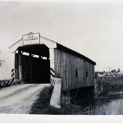
Description
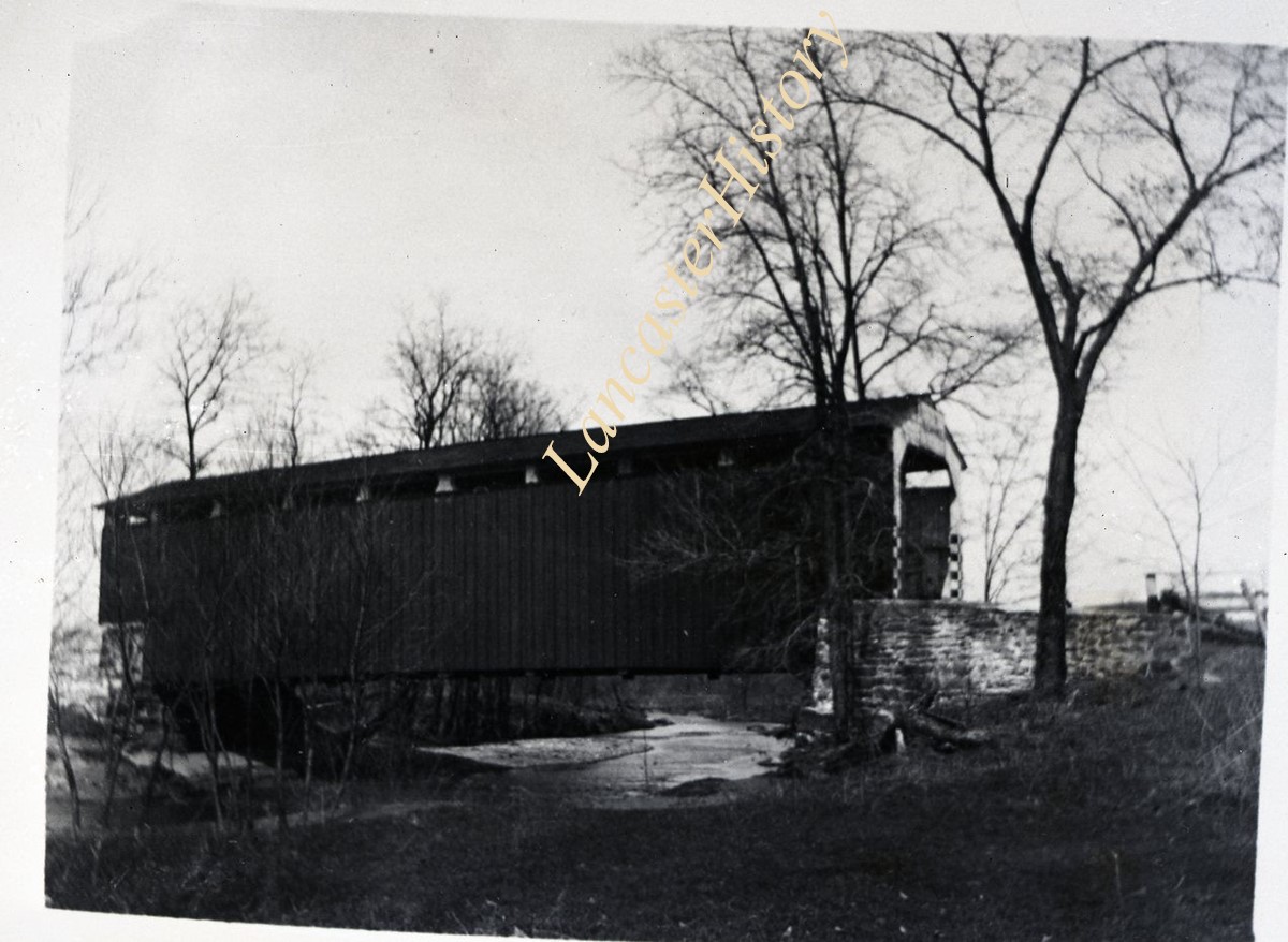
Colemanville Covered bridge over the Pequea Creek.
Provenance
Transferred from the Bob Swartz Collection at the Lower Merion Historical Society, May 6, 2014.
Date Range
c. 1930
Creator
Kurtz, Howard G. Sr.
Storage Location
LancasterHistory, Lancaster, PA
Search Terms
Covered bridges
Pequea Creek
Colemanville Covered Bridge
Colemanville, Conestoga Twp.
Place
Conestoga Twp.
Object Name
Negative
Film Size
3 x 4.75 inches
Object ID
1-19-01-36
Images
Less detail
More Like This
Permalink
Toggle Full Record
Negative
https://collections.lancasterhistory.org/en/permalink/c8a8de1c-c0f4-4ffe-b167-332834213455
Collection
General Collection
Object ID
1-19-01-37
Date Range
c. 1930
More detail
1 image
Object Name
Negative
Collection
General Collection
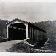
Description
Covered bridge north of Leaman Place over the Pequea Creek.
Provenance
Transferred from the Bob Swartz Collection at the Lower Merion Historical Society, May 6, 2014.
Date Range
c. 1930
Creator
Kurtz, Howard G. Sr.
Storage Location
LancasterHistory, Lancaster, PA
Search Terms
Covered bridges
Pequea Creek
Leaman Place, Paradise Twp.
Place
Paradise Twp.
Object Name
Negative
Film Size
3 x 4.75 inches
Object ID
1-19-01-37
Images
Less detail
More Like This
Permalink
Toggle Full Record
Negative
https://collections.lancasterhistory.org/en/permalink/a88574a0-a9e0-4a8a-ab6d-126790338010
Collection
General Collection
Object ID
1-19-01-41
Date Range
c. 1930
More detail
1 image
Object Name
Negative
Collection
General Collection
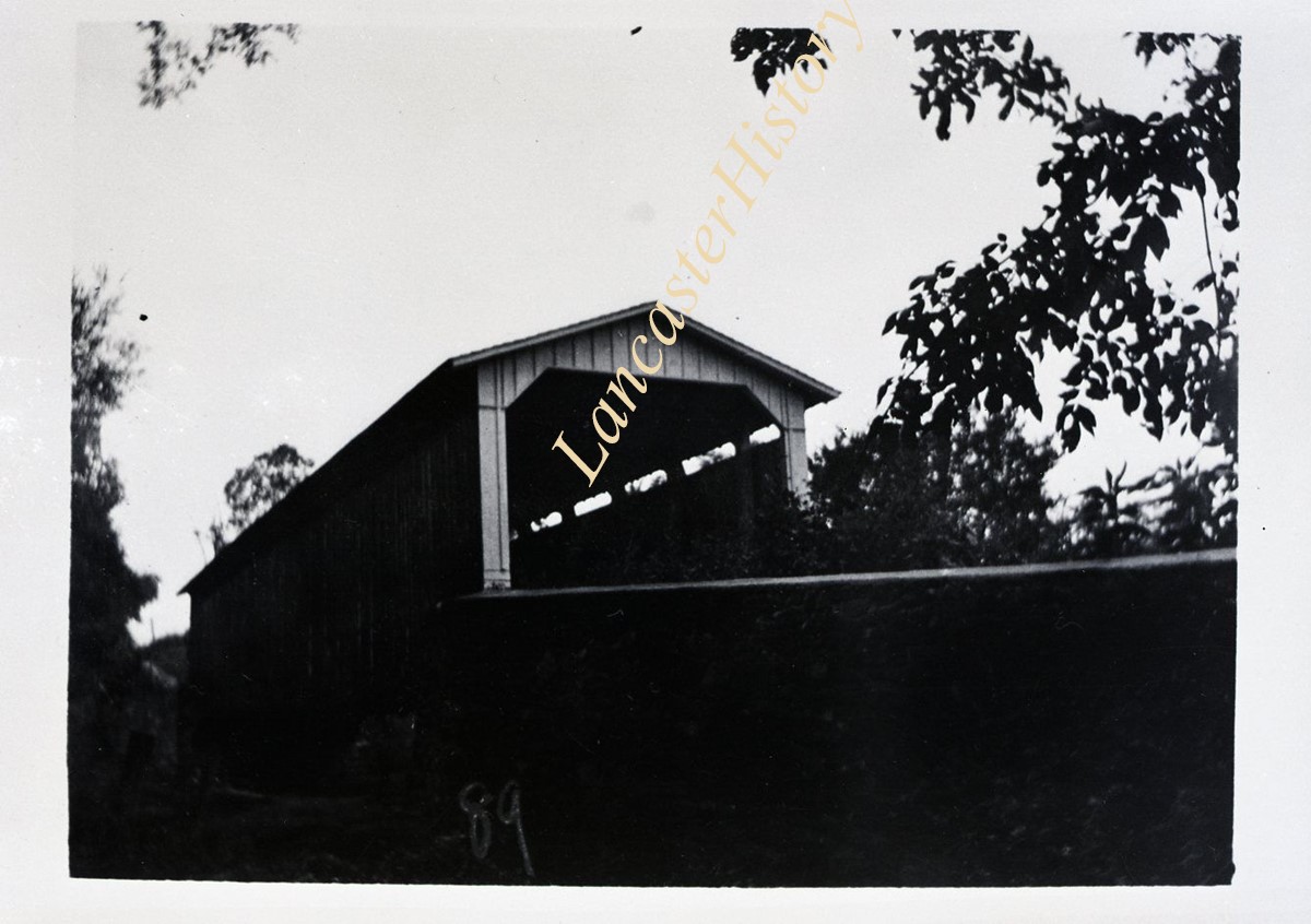
Description
Covered bridge over the Conestoga River at Eden
Provenance
Transferred from the Bob Swartz Collection at the Lower Merion Historical Society, May 6, 2014.
Date Range
c. 1930
Creator
Kurtz, Howard G. Sr.
Storage Location
LancasterHistory, Lancaster, PA
Search Terms
Covered bridges
Eden, Manheim Twp.
Conestoga River
Place
Manheim Twp.
Object Name
Negative
Film Size
3 x 4.75 inches
Object ID
1-19-01-41
Images
Less detail
More Like This
Permalink
Toggle Full Record
Negative
https://collections.lancasterhistory.org/en/permalink/8f49e6de-93a0-4953-bd98-273650487084
Collection
General Collection
Object ID
1-19-01-49
Date Range
c. 1930
More detail
1 image
Object Name
Negative
Collection
General Collection
Description
Covered bridge over Beaver Creek near Refton
Provenance
Transferred from the Bob Swartz Collection at the Lower Merion Historical Society, May 6, 2014.
Date Range
c. 1930
Creator
Kurtz, Howard G. Sr.
Storage Location
LancasterHistory, Lancaster, PA
Search Terms
Covered bridges
Beaver Creek
Refton, Strasburg Twp.
Place
Strasburg Twp.
Object Name
Negative
Film Size
3 x 4.75 inches
Object ID
1-19-01-49
Images
Less detail
More Like This
Permalink
9 records – page 1 of 1.
Prev
Next