It appears no script is enabled within your browser. Please enable JavaScript to use this site.
Skip header and navigation
Toggle navigation
Collections
Search
Help
Privacy
Your Selections:
0
Items
Staff Login
Revise Search
Revise Search
Revise search
Search
Data Source
Photographs
43
Archives
1
×
Data Source
All
A
B
C
D
E
F
G
H
I
J
K
L
M
N
O
P
Q
R
S
T
U
V
W
X
Y
Z
Sort
By Count
Alphabetical
Filtered by
Filter
Loading...
Collection
General Collection
29
Covered Bridge Album
13
Bridge Information Compiled by Benjamin Weaver
1
Mildred Shopf Smiley Photograph Collection
1
×
Collection
All
A
B
C
D
E
F
G
H
I
J
K
L
M
N
O
P
Q
R
S
T
U
V
W
X
Y
Z
Sort
By Count
Alphabetical
Filtered by
Filter
Loading...
Subject
Documentary Artifact
417
North Queen Street
294
Urban renewal
285
Photographs
261
Construction
184
Demolition
156
Bowman Technical School
103
Manuscript groups
102
Finding aids
100
Letters
74
Slides (Photography)
72
Correspondence
67
More
×
Subject
All
A
B
C
D
E
F
G
H
I
J
K
L
M
N
O
P
Q
R
S
T
U
V
W
X
Y
Z
Sort
By Count
Alphabetical
Filtered by
Filter
Loading...
Name
Gaintner, Jay Richard
12
Bond, G. Ross
4
Bond, George Ross
4
Lockwood, Louis
2
Bear, Isaac
1
Bloomberg, Martin
1
Hand, Edward
1
Krone, Herbert Brickley
1
Sensenig, Israel
1
Shand, William
1
Shearer, Isaac
1
Weaver, Benjamin
1
More
×
Name
All
A
B
C
D
E
F
G
H
I
J
K
L
M
N
O
P
Q
R
S
T
U
V
W
X
Y
Z
Sort
By Count
Alphabetical
Filtered by
Filter
Loading...
Place
Manheim Twp.
7
East Earl Twp.
6
Caernarvon Twp.
4
Earl Twp.
4
West Earl Twp.
4
Lancaster Twp.
3
Lancaster
2
×
Place
All
A
B
C
D
E
F
G
H
I
J
K
L
M
N
O
P
Q
R
S
T
U
V
W
X
Y
Z
Sort
By Count
Alphabetical
Filtered by
Filter
Loading...
Decade
1760s
1
1790s
1
1800s
2
1810s
20
1820s
19
1830s
19
1840s
18
1850s
18
1860s
18
1870s
18
1880s
20
1890s
38
1900s
63
1910s
40
1920s
62
1930s
22
1940s
2
1950s
1960s
4
1970s
1990s
15
2000s
3
×
Decade
All
A
B
C
D
E
F
G
H
I
J
K
L
M
N
O
P
Q
R
S
T
U
V
W
X
Y
Z
Sort
By Count
Alphabetical
Filtered by
Filter
Loading...
Material
Print, Photographic
43
Archive
1
×
Material
All
A
B
C
D
E
F
G
H
I
J
K
L
M
N
O
P
Q
R
S
T
U
V
W
X
Y
Z
Sort
By Count
Alphabetical
Filtered by
Filter
Loading...
Archival Hierarchy
Fonds
1
×
Archival Hierarchy
All
A
B
C
D
E
F
G
H
I
J
K
L
M
N
O
P
Q
R
S
T
U
V
W
X
Y
Z
Sort
By Count
Alphabetical
Filtered by
Filter
Loading...
Online Media
Image
43
PDF
1
×
Online Media
All
A
B
C
D
E
F
G
H
I
J
K
L
M
N
O
P
Q
R
S
T
U
V
W
X
Y
Z
Sort
By Count
Alphabetical
Filtered by
Filter
Loading...
Advanced Search
Help
more like: 3EA739A1-FD10-400D-B9C6-269786291620
1950s
1970s
Conestoga River
Sorted by
Relevance
Sort by Title
Expand All
Collapse All
List View
Gallery View
Print
10 records – page 1 of 1.
Prev
Next
Toggle Full Record
Print, Photographic
https://collections.lancasterhistory.org/en/permalink/b8d3920a-08f4-479d-94b0-412273318940
Collection
General Collection
Object ID
1-09-03-89
Date Range
August 1956
More detail
1 image
Object Name
Print, Photographic
Collection
General Collection
Description
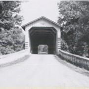
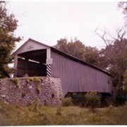
Covered bridge, Possibly Second Lock bridge, on the Conestoga River north of New Danville between Pequea and Lancaster townships.
Provenance
Lancaster County covered bridge photos taken by M. E. Schroll and Kathryn L. Sauder taken between 1956 and 1958.
Date Range
August 1956
Storage Location
LancasterHistory, Lancaster, PA
Subcategory
Documentary Artifact
Search Terms
Covered bridges
Second Lock Bridge
Conestoga River
New Danville, Pequea Twp.
Pequea Twp.
Lancaster Twp.
Object Name
Print, Photographic
Print Size
3.5 x 3.5 inches
Condition
Good
Object ID
1-09-03-89
Images
Less detail
More Like This
Permalink
Toggle Full Record
Print, Photographic
https://collections.lancasterhistory.org/en/permalink/6270a8ec-da9a-4431-95f8-876193479897
Collection
General Collection
Object ID
1-09-03-90
Date Range
August 7, 1958
More detail
1 image
Object Name
Print, Photographic
Collection
General Collection
Description
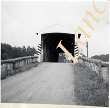
Possibly Second Lock bridge over the Conestoga north of New Danville between Pequea and Lancaster townships.
Provenance
Lancaster County covered bridge photos taken by M. E. Schroll and Kathryn L. Sauder taken between 1956 and 1958.
Date Range
August 7, 1958
Storage Location
LancasterHistory, Lancaster, PA
Subcategory
Documentary Artifact
Search Terms
Second Lock Bridge
Conestoga River
New Danville, Pequea Twp.
Pequea Twp.
Lancaster Twp.
Covered bridges
Object Name
Print, Photographic
Print Size
3.5 x 3.5 inches
Condition
Good
Object ID
1-09-03-90
Images
Less detail
More Like This
Permalink
Toggle Full Record
Print, Photographic
https://collections.lancasterhistory.org/en/permalink/cb827489-9f2b-4240-9168-690980811317
Collection
General Collection
Title
Bitzer's Mill Covered Bridge
Object ID
1-21-03-33
Date Range
24 October 1958
More detail
1 image
Object Name
Print, Photographic
Collection
General Collection
Title
Bitzer's Mill Covered Bridge
Description
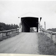
Covered bridge near Fairmount. Possibly Bitzer's Mill Covered Bridge.
Date Range
24 October 1958
Creator
Bond, George Ross
Storage Location
LancasterHistory, Lancaster, PA
Storage Room
Archives West
People
Bond, G. Ross
Subject
Photographs
Classification
1-21-03-33
Search Terms
Covered bridges
Bitzer's Mill Covered Bridge
Fairmount, West Earl Twp.
Conestoga River
Place
West Earl Twp.
Object Name
Print, Photographic
Original or Copy
Original
Print Size
3.25 x 4.75 inches
Dimention Details
Photograph is glued to black paper
Object ID
1-21-03-33
Credit
Courtesy of LancasterHistory, Lancaster, Pennsylvania
Images
Less detail
More Like This
Permalink
Toggle Full Record
Print, Photographic
https://collections.lancasterhistory.org/en/permalink/e95398c0-909d-4c0e-824e-581690398748
Collection
General Collection
Title
Covered bridge near Goodville
Object ID
1-21-03-35
Date Range
7 November 1958
More detail
1 image
Object Name
Print, Photographic
Collection
General Collection
Title
Covered bridge near Goodville
Description
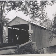
Covered bridge north of Goodville.
Date Range
7 November 1958
Creator
Bond, George Ross
Storage Location
LancasterHistory, Lancaster, PA
Storage Room
Archives West
People
Bond, G. Ross
Subject
Photographs
Classification
1-21-03-35
Search Terms
Covered bridges
Goodville, East Earl Twp.
Conestoga River
Place
East Earl Twp.
Object Name
Print, Photographic
Original or Copy
Original
Print Size
3.25 x 4.75 inches
Dimention Details
Photograph is glued to black paper
Object ID
1-21-03-35
Credit
Courtesy of LancasterHistory, Lancaster, Pennsylvania
Images
Less detail
More Like This
Permalink
Toggle Full Record
Print, Photographic
https://collections.lancasterhistory.org/en/permalink/fd31f801-338a-4091-a7b9-401946346360
Collection
General Collection
Title
Photograph- End view of Kurtz's Mill covered bridge across Big Conestoga, north of Fairmount.
Object ID
1-09-03-34
Date Range
August 1956
More detail
1 image
Object Name
Print, Photographic
Collection
General Collection
Title
Photograph- End view of Kurtz's Mill covered bridge across Big Conestoga, north of Fairmount.
Description
End view of Kurtz's Mill covered bridge across Big Conestoga.
Provenance
Lancaster County covered bridge photos taken by M. E. Schroll and Kathryn L. Sauder taken between 1956 and 1958.
Date Range
August 1956
Storage Location
LancasterHistory, Lancaster, PA
Subcategory
Documentary Artifact
Search Terms
Covered bridges
Conestoga River
Kurtz's Mill Covered Bridge
Martindale, Earl Twp.
Place
Earl Twp.
Object Name
Print, Photographic
Print Size
3.5 x 3.5 inches
Condition
Good
Object ID
1-09-03-34
Images
Less detail
More Like This
Permalink
Toggle Full Record
Print, Photographic
https://collections.lancasterhistory.org/en/permalink/88e89a0f-cb50-4753-af99-102674568080
Collection
General Collection
Object ID
1-09-03-73
Date Range
September 5, 1956
More detail
1 image
Object Name
Print, Photographic
Collection
General Collection
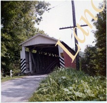
Description
Spring Grove covered bridge, also called Overholtzer's Mill covered bridge, on the Conestoga River.
Provenance
Lancaster County covered bridge photos taken by M. E. Schroll and Kathryn L. Sauder taken between 1956 and 1958.
Date Range
September 5, 1956
Storage Location
LancasterHistory, Lancaster, PA
Subcategory
Documentary Artifact
Search Terms
Spring Grove, East Earl Twp.
Covered bridges
Oberholtzer's Mill
Conestoga River
Place
East Earl Twp.
Object Name
Print, Photographic
Print Size
3.5 x 3.5 inches
Condition
Good
Object ID
1-09-03-73
Images
Less detail
More Like This
Permalink
Toggle Full Record
Print, Photographic
https://collections.lancasterhistory.org/en/permalink/5dfb9a8d-37c7-4971-925e-320238909031
Collection
General Collection
Object ID
1-09-03-74
Date Range
August 6, 1958
More detail
1 image
Object Name
Print, Photographic
Collection
General Collection
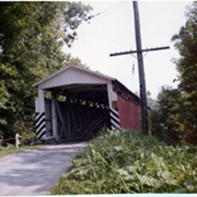
Description
Spring Grove covered bridge, also called Overholtzer's Mill covered bridge, on the Conestoga River.
Provenance
Lancaster County covered bridge photos taken by M. E. Schroll and Kathryn L. Sauder taken between 1956 and 1958.
Date Range
August 6, 1958
Storage Location
LancasterHistory, Lancaster, PA
Subcategory
Documentary Artifact
Search Terms
Spring Grove, East Earl Twp.
Covered bridges
Oberholtzer's Mill
Conestoga River
Place
East Earl Twp.
Object Name
Print, Photographic
Print Size
3.5 x 3.5 inches
Condition
Good
Object ID
1-09-03-74
Images
Less detail
More Like This
Permalink
Toggle Full Record
Print, Photographic
https://collections.lancasterhistory.org/en/permalink/5e93a77a-b151-4c88-95ba-423210273245
Collection
General Collection
Object ID
1-09-03-79
Date Range
August 13, 1958
More detail
1 image
Object Name
Print, Photographic
Collection
General Collection
Description
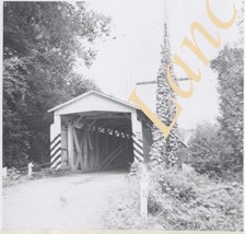
Bitzer's Mill covered bridge, also called Eberly's Cider Mill covered bridge, on the Conestoga River north of Fairmount.
Provenance
Lancaster County covered bridge photos taken by M. E. Schroll and Kathryn L. Sauder taken between 1956 and 1958.
Date Range
August 13, 1958
Storage Location
LancasterHistory, Lancaster, PA
Subcategory
Documentary Artifact
Search Terms
Bitzer's Mill
Covered bridges
Eberly's Cider Mill
Conestoga River
Fairmount, West Earl Twp.
Place
West Earl Twp.
Object Name
Print, Photographic
Print Size
3.5 x 3.5 inches
Condition
Good
Object ID
1-09-03-79
Images
Less detail
More Like This
Permalink
Toggle Full Record
Print, Photographic
https://collections.lancasterhistory.org/en/permalink/b2bafc66-5a5c-4223-af82-341496793242
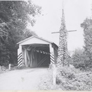
Collection
General Collection
Object ID
1-09-03-80
Date Range
August 13, 1958
More detail
1 image
Object Name
Print, Photographic
Collection
General Collection
Description
Bitzer's Mill covered bridge, also called Eberly's Cider Mill covered bridge, on the Conestoga River north of Fairmount.
Provenance
Lancaster County covered bridge photos taken by M. E. Schroll and Kathryn L. Sauder taken between 1956 and 1958.
Date Range
August 13, 1958
Storage Location
LancasterHistory, Lancaster, PA
Subcategory
Documentary Artifact
Search Terms
Bitzer's Mill
Covered bridges
Eberly's Cider Mill
Conestoga River
Fairmount, West Earl Twp.
Place
West Earl Twp.
Object Name
Print, Photographic
Print Size
3.5 x 3.5 inches
Condition
Good
Object ID
1-09-03-80
Images
Less detail
More Like This
Permalink
Toggle Full Record
Print, Photographic
https://collections.lancasterhistory.org/en/permalink/2490d8f5-2c33-4bd3-9d29-821404032960
Collection
General Collection
Title
Kurtz's Mill Covered Bridge
Object ID
1-21-03-58
Date Range
26 April 1972
More detail
1 image
Object Name
Print, Photographic
Collection
General Collection
Title
Kurtz's Mill Covered Bridge
Description
Kurtz's Mill Covered Bridge near Hinkletown.
Date Range
26 April 1972
Storage Location
LancasterHistory, Lancaster, PA
Storage Room
Archives West
People
Bond, G. Ross
Subject
Photographs
Classification
1-21-03-58
Search Terms
Mills
Covered bridges
Kurtz's Mill Covered Bridge
Hinkletown, Earl Twp.
Conestoga River
Place
Earl Twp.
Object Name
Print, Photographic
Original or Copy
Original
Print Size
4 x 5 inches
Dimention Details
Photograph is glued to black paper
Object ID
1-21-03-58
Credit
Courtesy of LancasterHistory, Lancaster, Pennsylvania
Images
Less detail
More Like This
Permalink
10 records – page 1 of 1.
Prev
Next