Skip header and navigation

Revise Search

10 records – page 1 of 1.

Collection
Covered Bridge Album
Object ID
A-12-01-02
Date Range
1970
  1 image  
Object Name
Print, Photographic
Collection
Covered Bridge Album
Description
Baumgardner Mill Bridge between Martic Forge and Marticville
Date Range
1970
Creator
Krone, Herbert Brickley
Storage Location
LancasterHistory, Lancaster, PA
Subcategory
Documentary Artifact
Search Terms
Bridges
Covered bridges
Marticville, Martic Twp.
Martic Forge, Martic Twp.
Place
Martic Twp.
Object Name
Print, Photographic
Print Size
8 x 10 inches
Object ID
A-12-01-02
Images
Less detail
Collection
Covered Bridge Album
Object ID
A-11-01-29
Date Range
1950
  1 image  
Object Name
Print, Photographic
Collection
Covered Bridge Album
Description
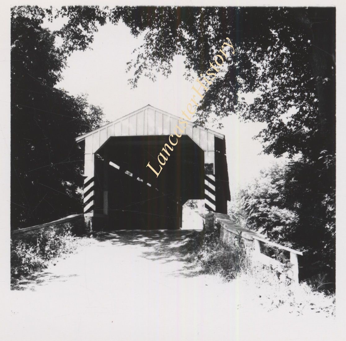
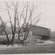
Daniel Good's Fording, one mile northeast of Marticville between Pequea and Providence Townships. State supervised on road LR 36008, built 1855, single span 79 feet long.
Date Range
1950
Creator
Gaintner, Jay Richard
Storage Location
LancasterHistory, Lancaster, PA
People
Good, Daniel
Subcategory
Documentary Artifact
Search Terms
Bridges
Covered bridges
Pequea Creek
Marticville, Martic Twp.
Object Name
Print, Photographic
Print Size
8 x 10 inches
Object ID
A-11-01-29
Images
Less detail
Collection
Covered Bridge Album
Object ID
A-11-01-30
Date Range
1950
  1 image  
Object Name
Print, Photographic
Collection
Covered Bridge Album
Description
Baumgardner's Mill, .5 mile northeast of Marticville between Pequea and Providence Townships. County maintained on road T-425, built 1860, single span 111 feet long.
Date Range
1950
Creator
Gaintner, Jay Richard
Storage Location
LancasterHistory, Lancaster, PA
Subcategory
Documentary Artifact
Search Terms
Bridges
Covered bridges
Pequea Creek
Marticville, Martic Twp.
Object Name
Print, Photographic
Print Size
8 x 10 inches
Object ID
A-11-01-30
Images
Less detail
Collection
Scrapbook Collection
Title
Catharine B. Spitler Scrapbook, Book 1, 1937-1943
Catharine B. Spitler Scrapbook, Book 2, 24 December 1971- 15 April 1987
Object ID
MG0434_Box079and080
Date Range
1937-1943; 1971-1987
Collection
Scrapbook Collection
Title
Catharine B. Spitler Scrapbook, Book 1, 1937-1943
Catharine B. Spitler Scrapbook, Book 2, 24 December 1971- 15 April 1987
Description
Catharine B. Spitler, a resident of Landisville, Pennsylvania, compiled these scrapbooks. Book one contains information primarily about World War II. The newspaper clippings include information about Lancaster natives, both men and women that were involved in World War II, including ranks and location of service. There are also articles about the United States involvement in World War II. Interesting local articles and programs discuss the World War II Memorial in West Hempfield Township. Columbia's Sesquicentennial was documented through a series of newspaper clippings located in this scrapbook.
Book two is a compilation of newspaper clippings, engagement announcements, wedding announcements and obituaries pertaining to Lancastrians. Locations around Lancaster County that were mentioned are as follows: Lancaster, Hempfield, Ephrata, Maytown and Mount Joy. An interesting subject within the second scrapbook is the1972 Flood of Lancaster (Hurricane Agnes).
Date Range
1937-1943; 1971-1987
Creation Date
1937-1943; 1971-1987
Year Range From
1937
Year Range To
1987
Creator
Spitler, Catharine Bard, 1911-1989, compiler
Storage Location
LancasterHistory, Lancaster, PA
Storage Room
Archives South
Storage Wall
Side 22
People
Spitler, Catharine Bard
Subjects
Announcements
Church buildings--Pennsylvania--Lancaster County
Clippings (Books, newspapers, etc.)
Ephrata Cloister
Floods--Pennsylvania
Hurricane Agnes, 1972
Hurricanes
Methodists--Pennsylvania
Obituaries
Programs (Publications)
Scrapbooks
World War, 1939-1945
Search Terms
Clippings (Books, newspapers, etc.)
Columbia
Ephrata
Lancaster
Maytown, East Donegal Twp.
Mount Joy
Newspaper clippings
Obituaries
Scrapbooks
West Hempfield Twp.
World War II
WWII
Extent
2 volumes
Object Name
Scrapbook
Language
English
Object ID
MG0434_Box079and080
Location of Originals
LancasterHistory, Lancaster, Pennsylvania
Notes
Preferred Citation: Title or description of item, date (day, month, year), Collection Title (MG#), Box #, Folder #, (or Object ID), LancasterHistory, Lancaster, Pennsylvania. URL if applicable. Date accessed (day, month, year).
Access Conditions / Restrictions
No restrictions. Please request these items by contacting Research@LancasterHistory.org prior to your visit.
Copyright
These items may be photographed. Please direct questions to Research Center Staff at Research@LancasterHistory.org.
Permission for reproduction and/or publication must be obtained in writing from LancasterHistory.
Credit
Courtesy of LancasterHistory, Lancaster, Pennsylvania.
Other Numbers
MG-434
Other Number
MG-434, Boxes 79 and 80
Classification
MG0434
Description Level
Item
Custodial History
Cataloged by CRB, October 2007. Added to database, 28 September 2023.
Previously housed in the Scrapbook Collection, Books 128 and 130.
This project was funded by the Pennsylvania Historical and Museum Commission, ME60112, 2007-2008.
Less detail
Collection
Covered Bridge Album
Object ID
A-11-01-01
Date Range
1950
  1 image  
Object Name
Print, Photographic
Collection
Covered Bridge Album
Description
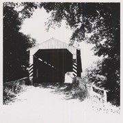
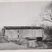
Poole Forge covered bridge, one mile west of Churchtown in Caernarvon Township. State supervised bridge on road LR 36053, built 1859, single span 99 feet long.
Date Range
1950
Creator
Gaintner, Jay Richard
Storage Location
LancasterHistory, Lancaster, PA
Subcategory
Documentary Artifact
Search Terms
Bridges
Covered bridges
Poole Forge
Churchtown, Caernarvon Twp.
Conestoga River
Place
Caernarvon Twp.
Object Name
Print, Photographic
Print Size
8 x 10 inches
Object ID
A-11-01-01
Images
Less detail
Collection
Covered Bridge Album
Object ID
A-11-01-02
Date Range
1950
  1 image  
Object Name
Print, Photographic
Collection
Covered Bridge Album
Description
Isaac Shearer's Mill covered bridge, one mile north of Goodville in Caernarvon Township. County maintained on road T-773, built 1878, single span 88 feet long.
Date Range
1950
Creator
Gaintner, Jay Richard
Storage Location
LancasterHistory, Lancaster, PA
People
Shearer, Isaac
Subcategory
Documentary Artifact
Search Terms
Bridges
Covered bridges
Mills
Churchtown, Caernarvon Twp.
Conestoga River
Place
Caernarvon Twp.
Object Name
Print, Photographic
Print Size
8 x 10 inches
Object ID
A-11-01-02
Images
Less detail
Collection
Covered Bridge Album
Object ID
A-11-01-03
Date Range
1950
  1 image  
Object Name
Print, Photographic
Collection
Covered Bridge Album
Description
Israel Sensenig's covered bridge near Martindale in East Earl Township. State supervised on road LR 36013, built 1857, single span 65 feet long.
Date Range
1950
Creator
Gaintner, Jay Richard
Storage Location
LancasterHistory, Lancaster, PA
People
Sensenig, Israel
Subcategory
Documentary Artifact
Search Terms
Bridges
Covered bridges
Mills
Martindale, Earl Twp.
Conestoga River
Place
East Earl Twp.
Object Name
Print, Photographic
Print Size
8 x 10 inches
Object ID
A-11-01-03
Images
Less detail
Collection
Covered Bridge Album
Object ID
A-11-01-04
Date Range
1950
  1 image  
Object Name
Print, Photographic
Collection
Covered Bridge Album
Description
Isaac Bear's Mill covered bridge, one mile southwest of Martindale in East Earl Township. County maintained on road T-674, built in 1876, single span 94 feet long.
Date Range
1950
Creator
Gaintner, Jay Richard
Storage Location
LancasterHistory, Lancaster, PA
People
Bear, Isaac
Subcategory
Documentary Artifact
Search Terms
Bridges
Covered bridges
Mills
Martindale, Earl Twp.
Conestoga River
Place
East Earl Twp.
Object Name
Print, Photographic
Print Size
8 x 10 inches
Object ID
A-11-01-04
Images
Less detail
Collection
Covered Bridge Album
Object ID
A-11-01-06
Date Range
1950
  1 image  
Object Name
Print, Photographic
Collection
Covered Bridge Album
Description
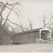
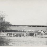
Bushong's Mill, near Oregon between Upper Leacock and Manheim Townships. State supervised on road LR 36009, built in 1843, longest single span in the county, 195 feet long.
Date Range
1950
Creator
Gaintner, Jay Richard
Storage Location
LancasterHistory, Lancaster, PA
Subcategory
Documentary Artifact
Search Terms
Bridges
Covered bridges
Oregon, Manheim Twp.
Mills
Conestoga River
Object Name
Print, Photographic
Print Size
8 x 10 inches
Object ID
A-11-01-06
Images
Less detail
Collection
Covered Bridge Album
Object ID
A-11-01-12
Date Range
1950
  1 image  
Object Name
Print, Photographic
Collection
Covered Bridge Album
Description
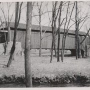
Slackwater, aslo known as Shober's Paper Mill, one mile south of Millersville between Conestoga and Manor Townships. State supervised on road LR 36008, oldest bridge still standing, built 1839, double span 269 feet long.
Date Range
1950
Creator
Gaintner, Jay Richard
Storage Location
LancasterHistory, Lancaster, PA
Subcategory
Documentary Artifact
Search Terms
Bridges
Covered bridges
Mills
Conestoga River
Slackwater, Conestoga Twp.
Object Name
Print, Photographic
Print Size
8 x 10 inches
Object ID
A-11-01-12
Images
Less detail

10 records – page 1 of 1.