It appears no script is enabled within your browser. Please enable JavaScript to use this site.
Skip header and navigation
Toggle navigation
Collections
Search
Help
Privacy
Your Selections:
0
Items
Staff Login
Revise Search
Revise Search
Revise search
Search
Data Source
Photographs
4811
Archives
304
Artifacts
23
×
Data Source
All
A
B
C
D
E
F
G
H
I
J
K
L
M
N
O
P
Q
R
S
T
U
V
W
X
Y
Z
Sort
By Count
Alphabetical
Filtered by
Filter
Loading...
Collection
General Collection
1639
Gerald High Schoolhouse Photo Album
432
Fulton Opera House Collection
325
Kelly Williams Schoolhouse Photo Album
307
Lancaster Recreation Commission Photograph Collection
291
Discover Lancaster Photograph Collection
242
Lloyd E. Eckert Korean War Album
220
Sarah Ann Stauffer Photograph Collection
213
Actors Company Photograph Collection
158
Quarter Sessions
143
Paul Shaub - United Steel Workers Local 285 Photograph Collection
137
James Buchanan Foundation Photograph Collection
115
More
×
Collection
All
A
B
C
D
E
F
G
H
I
J
K
L
M
N
O
P
Q
R
S
T
U
V
W
X
Y
Z
Sort
By Count
Alphabetical
Filtered by
Filter
Loading...
Subject
Documentary Artifact
Schoolhouses
735
Fulton Opera House
406
Theatrical performances
362
Military
250
Korean War
224
Covered bridges
195
Demolition
155
Wheatland
122
Labor unions
119
James Buchanan Presidential Library
115
Politics
112
More
×
Subject
All
A
B
C
D
E
F
G
H
I
J
K
L
M
N
O
P
Q
R
S
T
U
V
W
X
Y
Z
Sort
By Count
Alphabetical
Filtered by
Filter
Loading...
Name
Williams, Kelly
307
Stahl, Lori
76
Casey, Bob
73
Loose, John Ward Willson
58
Gaintner, Jay Richard
50
Meyer, Francis E.
49
Rothwell, Gerald
42
Bond, George Ross
29
Warfel, Mary
23
Lancaster Newspapers, Inc.
21
Krone, Herbert
19
Pioso, Moses
18
More
×
Name
All
A
B
C
D
E
F
G
H
I
J
K
L
M
N
O
P
Q
R
S
T
U
V
W
X
Y
Z
Sort
By Count
Alphabetical
Filtered by
Filter
Loading...
Place
Lancaster
1437
Lancaster Twp.
218
Manheim Twp.
79
West Cocalico Twp.
74
Strasburg Twp.
61
Manor Twp.
56
Bart Twp.
48
Carlisle, Cumberland County, Pennsylvania
46
East Hempfield Twp.
41
Leacock Twp.
41
East Lampeter Twp.
40
Earl Twp.
38
More
×
Place
All
A
B
C
D
E
F
G
H
I
J
K
L
M
N
O
P
Q
R
S
T
U
V
W
X
Y
Z
Sort
By Count
Alphabetical
Filtered by
Filter
Loading...
Decade
1020s
1
1070s
1
1190s
4
1720s
5
1730s
220
1740s
1026
1750s
1383
1760s
7880
1770s
8216
1780s
8744
1790s
9047
1800s
10294
1810s
16782
1820s
17356
1830s
18709
1840s
21938
1850s
16722
1860s
16132
1870s
19403
1880s
29450
1890s
37709
1900s
20772
1910s
6485
1920s
6637
1930s
4237
1940s
2126
1950s
1960s
1924
1970s
5093
1980s
3933
1990s
2000s
1938
2010s
19
×
Decade
All
A
B
C
D
E
F
G
H
I
J
K
L
M
N
O
P
Q
R
S
T
U
V
W
X
Y
Z
Sort
By Count
Alphabetical
Filtered by
Filter
Loading...
Material
Print, Photographic
4625
Transparency, Slide
145
Record, Judicial
143
Indictment
113
Documents
47
Negative
31
Coin, Commemorative
11
Postcard
10
Medal, Commemorative
7
Scorecard
2
Album, Photograph
1
Calendar
1
More
×
Material
All
A
B
C
D
E
F
G
H
I
J
K
L
M
N
O
P
Q
R
S
T
U
V
W
X
Y
Z
Sort
By Count
Alphabetical
Filtered by
Filter
Loading...
Archival Hierarchy
Item
304
×
Archival Hierarchy
All
A
B
C
D
E
F
G
H
I
J
K
L
M
N
O
P
Q
R
S
T
U
V
W
X
Y
Z
Sort
By Count
Alphabetical
Filtered by
Filter
Loading...
Online Media
Image
4811
×
Online Media
All
A
B
C
D
E
F
G
H
I
J
K
L
M
N
O
P
Q
R
S
T
U
V
W
X
Y
Z
Sort
By Count
Alphabetical
Filtered by
Filter
Loading...
Advanced Search
Help
more like: A5907FE5-71F7-4F11-B534-258699902619
1950s
1990s
Documentary Artifact
Sorted by
Relevance
Sort by Title
Expand All
Collapse All
List View
Gallery View
Print
10 records – page 1 of 1.
Prev
Next
Toggle Full Record
Print, Photographic
https://collections.lancasterhistory.org/en/permalink/dd0e11ff-70e7-4dc0-8d36-073257198050
Collection
General Collection
Object ID
1-09-03-63
Date Range
August 1956
More detail
1 image
Object Name
Print, Photographic
Collection
General Collection
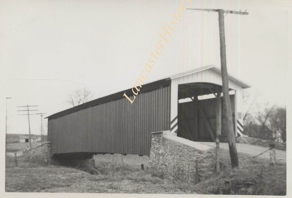
Description
Herrville covered bridge across the Pequea Creek south of Lime Valley.
Provenance
Lancaster County covered bridge photos taken by M. E. Schroll and Kathryn L. Sauder taken between 1956 and 1958.
Date Range
August 1956
Storage Location
LancasterHistory, Lancaster, PA
Subcategory
Documentary Artifact
Search Terms
Bridges
Covered bridges
Herrville, Pequea Twp.
Lime Valley, West Lampeter Twp.
Pequea Creek
Object Name
Print, Photographic
Print Size
3.5 x 3.5 inches
Condition
Good
Object ID
1-09-03-63
Images
Less detail
More Like This
Permalink
Toggle Full Record
Print, Photographic
https://collections.lancasterhistory.org/en/permalink/4ae27840-0787-4b12-80cc-309352173194
Collection
General Collection
Object ID
1-09-03-64
Date Range
August 1958
More detail
1 image
Object Name
Print, Photographic
Collection
General Collection
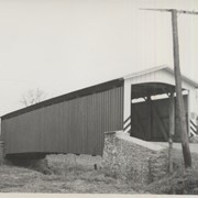
Description
Herrville covered bridge on the Pequea Creek south of Lime Valley.
Provenance
Lancaster County covered bridge photos taken by M. E. Schroll and Kathryn L. Sauder taken between 1956 and 1958.
Date Range
August 1958
Storage Location
LancasterHistory, Lancaster, PA
Subcategory
Documentary Artifact
Search Terms
Bridges
Covered bridges
Herrville, Pequea Twp.
Lime Valley, West Lampeter Twp.
Pequea Creek
Object Name
Print, Photographic
Print Size
3.5 x 3.5 inches
Condition
Good
Object ID
1-09-03-64
Images
Less detail
More Like This
Permalink
Toggle Full Record
Print, Photographic
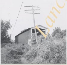
https://collections.lancasterhistory.org/en/permalink/411425f8-e2dd-4d14-b397-652064614095
Collection
General Collection
Title
Photograph- Mylin Gun Shop, Willow Street
Object ID
1-03-04-03
Date Range
c. 1950
More detail
1 image
Object Name
Print, Photographic
Collection
General Collection
Title
Photograph- Mylin Gun Shop, Willow Street
Description
Mylin Gun Shop, Willow Street
Provenance
From Herbert Krone Album No. 1
Date Range
c. 1950
Creator
Krone, Herbert Brickley
Storage Location
LancasterHistory, Lancaster, PA
Subcategory
Documentary Artifact
Search Terms
Gunsmiths
Willow Street, West Lampeter Twp.
Place
West Lampeter Twp.
Object Name
Print, Photographic
Print Size
4 x 4 inches
Object ID
1-03-04-03
Images
Less detail
More Like This
Permalink
Toggle Full Record
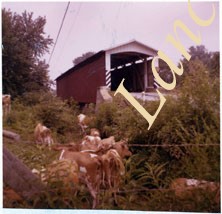
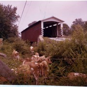
Print, Photographic
https://collections.lancasterhistory.org/en/permalink/1e9a2243-81fd-4997-9fc4-232342361435
Collection
Covered Bridge Album
Object ID
A-11-01-28
Date Range
1950
More detail
1 image
Object Name
Print, Photographic
Collection
Covered Bridge Album
Description
Hurtzinger's Mill, at Lime Valley, between Strasburg and West Lampeter Townships. County maintained on road T-498, built in 1871, single span 104 feet long.
Date Range
1950
Creator
Gaintner, Jay Richard
Storage Location
LancasterHistory, Lancaster, PA
Subcategory
Documentary Artifact
Search Terms
Bridges
Covered bridges
Mills
Pequea Creek
Lime Valley, West Lampeter Twp.
Object Name
Print, Photographic
Print Size
8 x 10 inches
Object ID
A-11-01-28
Images
Less detail
More Like This
Permalink
Toggle Full Record
Print, Photographic
https://collections.lancasterhistory.org/en/permalink/4bbec65e-0210-44c9-9eec-452372049972
Collection
General Collection
Object ID
1-09-04-03
Date Range
August 5, 1958
More detail
1 image
Object Name
Print, Photographic
Collection
General Collection
Description
Zook's Mill covered bridge on the Cocalico Creek on Log Cabin Road west of Brownstown between West Earl and Warwick townships.
Provenance
Lancaster County covered bridge photos taken by M. E. Schroll and Kathryn L. Sauder taken between 1956 and 1958.
Date Range
August 5, 1958
Storage Location
LancasterHistory, Lancaster, PA
Subcategory
Documentary Artifact
Search Terms
Bridges
Brownstown, West Earl Twp.
Cocalico Creek
Covered bridges
Creeks
Log Cabin Road
Rose Hill Bridge
Warwick Twp.
West Earl Twp.
Zook's Mill
Object Name
Print, Photographic
Print Size
3.5 x 4.5 inches
Condition
Good
Object ID
1-09-04-03
Images
Less detail
More Like This
Permalink
Toggle Full Record
Print, Photographic
https://collections.lancasterhistory.org/en/permalink/f6a46d93-9fb5-4ffb-9a04-812358765830
Collection
Gerald High Schoolhouse Photo Album
Object ID
GH-01-01-228
Date Range
1997
More detail
1 image
Object Name
Print, Photographic
Collection
Gerald High Schoolhouse Photo Album
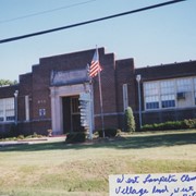
Description
West Lampeter High School, Village Road
Provenance
Gift of the widow of the late Gerald High. Digital images only.
Date Range
1997
Storage Location
LancasterHistory, Lancaster, PA
Subcategory
Documentary Artifact
Search Terms
Schoolhouses
West Lampeter High School
Place
West Lampeter Twp.
Object Name
Print, Photographic
Print Size
4 x 6 inches
Condition
Not Rated
Object ID
GH-01-01-228
Images
Less detail
More Like This
Permalink
Toggle Full Record
Print, Photographic
https://collections.lancasterhistory.org/en/permalink/ae510b6b-19f9-4812-9ff3-763000392164
Collection
Gerald High Schoolhouse Photo Album
Object ID
GH-01-01-110
Date Range
1997
More detail
1 image
Object Name
Print, Photographic
Collection
Gerald High Schoolhouse Photo Album
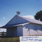
Description
Sunnyside West School, possibly Forest Road, Talmage
Provenance
Gift of the widow of the late Gerald High. Digital images only.
Date Range
1997
Storage Location
LancasterHistory, Lancaster, PA
Subcategory
Documentary Artifact
Search Terms
Schoolhouses
Sunnyside West School
West Earl Twp
Place
West Earl Twp.
Object Name
Print, Photographic
Print Size
4 x 6 inches
Condition
Not Rated
Object ID
GH-01-01-110
Images
Less detail
More Like This
Permalink
Toggle Full Record
Print, Photographic
https://collections.lancasterhistory.org/en/permalink/121f1eab-dfe2-4b8b-878b-772510878160
Collection
Gerald High Schoolhouse Photo Album
Object ID
GH-01-01-313
Date Range
1997
More detail
1 image
Object Name
Print, Photographic
Collection
Gerald High Schoolhouse Photo Album
Description
West Stevens School, Indiantown Road
Provenance
Gift of the widow of the late Gerald High. Digital images only.
Date Range
1997
Storage Location
LancasterHistory, Lancaster, PA
Subcategory
Documentary Artifact
Search Terms
Schoolhouses
West Stevens School
West Cocalico Twp.
Place
West Cocalico Twp.
Object Name
Print, Photographic
Print Size
4 x 6 inches
Condition
Not Rated
Object ID
GH-01-01-313
Images
Less detail
More Like This
Permalink
Toggle Full Record
Print, Photographic
https://collections.lancasterhistory.org/en/permalink/adf748a2-38eb-4fbc-9b00-493564116246
Collection
General Collection
Title
Photograph- White Rock covered bridge over the West Branch of the Octoraro Creek between Colerain and Little Britain townships.
Object ID
1-09-03-53
Date Range
September 1956
More detail
1 image
Object Name
Print, Photographic
Collection
General Collection
Title
Photograph- White Rock covered bridge over the West Branch of the Octoraro Creek between Colerain and Little Britain townships.
Description
White Rock covered bridge over the West Branch of the Octoraro Creek between Colerain and Little Britain townships.
Provenance
Lancaster County covered bridge photos taken by M. E. Schroll and Kathryn L. Sauder taken between 1956 and 1958.
Date Range
September 1956
Storage Location
LancasterHistory, Lancaster, PA
Subcategory
Documentary Artifact
Search Terms
Bridges
Colerain Twp.
Covered bridges
Creeks
Octoraro Creek, West Branch
White Rock Covered Bridge
White Rock Forge Covered Bridge
White Rock, Little Britain Twp.
Object Name
Print, Photographic
Print Size
3.5 x 3.5 inches
Condition
Good
Object ID
1-09-03-53
Images
Less detail
More Like This
Permalink
Toggle Full Record
Print, Photographic
https://collections.lancasterhistory.org/en/permalink/aee09825-bd3d-4c64-85d9-210349253712
Collection
General Collection
Title
Photograph- White Rock covered bridge over the West Branch of the Octoraro Creek between Colerain and Little Britain townships.
Object ID
1-09-03-54
Date Range
August 4, 1958
More detail
1 image
Object Name
Print, Photographic
Collection
General Collection
Title
Photograph- White Rock covered bridge over the West Branch of the Octoraro Creek between Colerain and Little Britain townships.
Description
White Rock covered bridge over the West Branch of the Octoraro Creek between Colerain and Little Britain townships.
Provenance
Lancaster County covered bridge photos taken by M. E. Schroll and Kathryn L. Sauder taken between 1956 and 1958.
Date Range
August 4, 1958
Storage Location
LancasterHistory, Lancaster, PA
Subcategory
Documentary Artifact
Search Terms
Bridges
Colerain Twp.
Covered bridges
Creeks
Octoraro Creek, West Branch
White Rock Covered Bridge
White Rock Forge Covered Bridge
White Rock, Little Britain Twp.
Object Name
Print, Photographic
Print Size
3.5 x 3.5 inches
Condition
Good
Object ID
1-09-03-54
Images
Less detail
More Like This
Permalink
10 records – page 1 of 1.
Prev
Next