It appears no script is enabled within your browser. Please enable JavaScript to use this site.
Skip header and navigation
Toggle navigation
Collections
Search
Help
Privacy
Your Selections:
0
Items
Staff Login
Revise Search
Revise Search
Revise search
Search
Data Source
Photographs
7
×
Data Source
All
A
B
C
D
E
F
G
H
I
J
K
L
M
N
O
P
Q
R
S
T
U
V
W
X
Y
Z
Sort
By Count
Alphabetical
Filtered by
Filter
Loading...
Collection
General Collection
5
Covered Bridge Safari Album
2
×
Collection
All
A
B
C
D
E
F
G
H
I
J
K
L
M
N
O
P
Q
R
S
T
U
V
W
X
Y
Z
Sort
By Count
Alphabetical
Filtered by
Filter
Loading...
Subject
Covered bridges
7
Documentary Artifact
Conestoga River
3
Kurtz's Mill Covered Bridge
3
Bridges
2
Martindale, Earl Twp.
2
Muddy Creek
2
Red Run covered bridge
2
Red Run
1
Sensenig's Mill
1
×
Subject
All
A
B
C
D
E
F
G
H
I
J
K
L
M
N
O
P
Q
R
S
T
U
V
W
X
Y
Z
Sort
By Count
Alphabetical
Filtered by
Filter
Loading...
Place
Lancaster
1965
Lancaster Twp.
100
Carlisle, Cumberland County, Pennsylvania
46
Manheim Twp.
41
Strasburg Twp.
27
West Cocalico Twp.
22
Manor Twp.
16
York, York County, Pennsylvania
13
Columbia
12
Ephrata Twp.
11
Rapho Twp.
10
West Earl Twp.
10
More
×
Place
All
A
B
C
D
E
F
G
H
I
J
K
L
M
N
O
P
Q
R
S
T
U
V
W
X
Y
Z
Sort
By Count
Alphabetical
Filtered by
Filter
Loading...
Decade
1730s
1
1740s
3
1750s
11
1760s
135
1770s
130
1780s
200
1790s
218
1800s
232
1810s
453
1820s
528
1830s
457
1840s
489
1850s
395
1860s
398
1870s
367
1880s
501
1890s
535
1900s
404
1910s
47
1920s
1
1930s
1
1950s
1960s
3
1970s
4
1990s
34
2000s
×
Decade
All
A
B
C
D
E
F
G
H
I
J
K
L
M
N
O
P
Q
R
S
T
U
V
W
X
Y
Z
Sort
By Count
Alphabetical
Filtered by
Filter
Loading...
Material
Print, Photographic
7
×
Material
All
A
B
C
D
E
F
G
H
I
J
K
L
M
N
O
P
Q
R
S
T
U
V
W
X
Y
Z
Sort
By Count
Alphabetical
Filtered by
Filter
Loading...
Online Media
Image
7
×
Online Media
All
A
B
C
D
E
F
G
H
I
J
K
L
M
N
O
P
Q
R
S
T
U
V
W
X
Y
Z
Sort
By Count
Alphabetical
Filtered by
Filter
Loading...
Advanced Search
Help
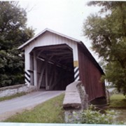
more like: 1E812EC0-127F-4E27-8FDB-148926944099
1950s
2000s
Earl Twp.
Documentary Artifact
Lancaster
Renunciation
Sorted by
Relevance
Sort by Title
Expand All
Collapse All
List View
Gallery View
Print
7 records – page 1 of 1.
Prev
Next
Toggle Full Record
Print, Photographic
https://collections.lancasterhistory.org/en/permalink/fd31f801-338a-4091-a7b9-401946346360
Collection
General Collection
Title
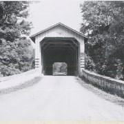
Photograph- End view of Kurtz's Mill covered bridge across Big Conestoga, north of Fairmount.
Object ID
1-09-03-34
Date Range
August 1956
More detail
1 image
Object Name
Print, Photographic
Collection
General Collection
Title
Photograph- End view of Kurtz's Mill covered bridge across Big Conestoga, north of Fairmount.
Description
End view of Kurtz's Mill covered bridge across Big Conestoga.
Provenance
Lancaster County covered bridge photos taken by M. E. Schroll and Kathryn L. Sauder taken between 1956 and 1958.
Date Range
August 1956
Storage Location
LancasterHistory, Lancaster, PA
Subcategory
Documentary Artifact
Search Terms
Covered bridges
Conestoga River
Kurtz's Mill Covered Bridge
Martindale, Earl Twp.
Place
Earl Twp.
Object Name
Print, Photographic
Print Size
3.5 x 3.5 inches
Condition
Good
Object ID
1-09-03-34
Images
Less detail
More Like This
Permalink
Toggle Full Record
Print, Photographic
https://collections.lancasterhistory.org/en/permalink/8e35bf98-08e2-416c-8cae-187699158633
Collection
General Collection
Object ID
1-09-03-76
Date Range
August 1956
More detail
1 image
Object Name
Print, Photographic
Collection
General Collection
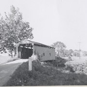
Description
Sensenig's Mill covered bridge, south of Martindale. Replaced in 1957 with a concrete bridge.
Provenance
Lancaster County covered bridge photos taken by M. E. Schroll and Kathryn L. Sauder taken between 1956 and 1958.
Date Range
August 1956
Storage Location
LancasterHistory, Lancaster, PA
Subcategory
Documentary Artifact
Search Terms
Sensenig's Mill
Covered bridges
Martindale, Earl Twp.
Place
Earl Twp.
Object Name
Print, Photographic
Print Size
3.5 x 3.5 inches
Condition
Good
Object ID
1-09-03-76
Images
Less detail
More Like This
Permalink
Toggle Full Record
Print, Photographic
https://collections.lancasterhistory.org/en/permalink/c9d0cd57-b5f6-4785-b53f-774787738625
Collection
Covered Bridge Safari Album
Object ID
A-65-01-23
Date Range
April 5, 2003
More detail
1 image
Object Name
Print, Photographic
Collection
Covered Bridge Safari Album
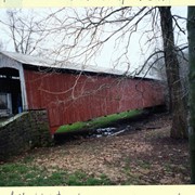
Description
Red Run covered bridge, built in 1866, formerly over Muddy Creek. The creek was diverted and a new bridge built over it in 1961.
Provenance
Photographs of a 2003 Theodore Burr Covered Bridge Society bridge safari.
Date Range
April 5, 2003
Storage Location
LancasterHistory, Lancaster, PA
Subcategory
Documentary Artifact
Search Terms
Covered bridges
Bridges
Red Run covered bridge
Muddy Creek
Place
Earl Twp.
Object Name
Print, Photographic
Print Size
4 x 6 inches
Object ID
A-65-01-23
Images
Less detail
More Like This
Permalink
Toggle Full Record
Print, Photographic
https://collections.lancasterhistory.org/en/permalink/6e707033-fe8c-4ad4-9040-910484236039
Collection
Covered Bridge Safari Album
Object ID
A-65-01-24
Date Range
April 5, 2003
More detail
1 image
Object Name
Print, Photographic
Collection
Covered Bridge Safari Album
Description
Red Run covered bridge, built in 1866, formerly over Muddy Creek. The creek was diverted and a new bridge built over it in 1961.
Provenance
Photographs of a 2003 Theodore Burr Covered Bridge Society bridge safari.
Date Range
April 5, 2003
Storage Location
LancasterHistory, Lancaster, PA
Subcategory
Documentary Artifact
Search Terms
Covered bridges
Bridges
Red Run covered bridge
Muddy Creek
Place
Earl Twp.
Object Name
Print, Photographic
Print Size
4 x 6 inches
Object ID
A-65-01-24
Images
Less detail
More Like This
Permalink
Toggle Full Record
Print, Photographic
https://collections.lancasterhistory.org/en/permalink/b8037eff-2d39-4ce1-aeb1-407618495169
Collection
General Collection
Object ID
1-10-03-62
Date Range
July 9, 2000
More detail
1 image
Object Name
Print, Photographic
Collection
General Collection
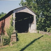
Description
Old Red Run covered bridge near Gristmill Road between Red Run Road and Sensenig Road.
Date Range
July 9, 2000
Storage Location
LancasterHistory, Lancaster, PA
Subcategory
Documentary Artifact
Search Terms
Covered bridges
Red Run
Place
Earl Twp.
Object Name
Print, Photographic
Print Size
3.5 x 5 inches
Object ID
1-10-03-62
Images
Less detail
More Like This
Permalink
Toggle Full Record
Print, Photographic
https://collections.lancasterhistory.org/en/permalink/7ee8a894-f2c8-40a8-a73d-184924791605
Collection
General Collection
Object ID
1-09-03-77
Date Range
August 1956
More detail
1 image
Object Name
Print, Photographic
Collection
General Collection
Description
Kurtz's Mill covered bridge across the Conestoga River.
Provenance
Lancaster County covered bridge photos taken by M. E. Schroll and Kathryn L. Sauder taken between 1956 and 1958.
Date Range
August 1956
Storage Location
LancasterHistory, Lancaster, PA
Subcategory
Documentary Artifact
Search Terms
Kurtz's Mill Covered Bridge
Covered bridges
Conestoga River
Place
Earl Twp.
Object Name
Print, Photographic
Print Size
3.5 x 3.5 inches
Condition
Good
Object ID
1-09-03-77
Images
Less detail
More Like This
Permalink
Toggle Full Record
Print, Photographic
https://collections.lancasterhistory.org/en/permalink/dc74fc5a-3399-4e48-ace8-012576676623
Collection
General Collection
Object ID
1-09-03-78
Date Range
August 7, 1958
More detail
1 image
Object Name
Print, Photographic
Collection
General Collection
Description
Kurtz's Mill covered bridge on the Conestoga River.
Provenance
Lancaster County covered bridge photos taken by M. E. Schroll and Kathryn L. Sauder taken between 1956 and 1958.
Date Range
August 7, 1958
Storage Location
LancasterHistory, Lancaster, PA
Subcategory
Documentary Artifact
Search Terms
Kurtz's Mill Covered Bridge
Covered bridges
Conestoga River
Place
Earl Twp.
Object Name
Print, Photographic
Print Size
3.5 x 3.5 inches
Condition
Good
Object ID
1-09-03-78
Images
Less detail
More Like This
Permalink
7 records – page 1 of 1.
Prev
Next