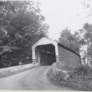
Wabank Mill bridge, also called Third Lock bridge, on the Conestoga River between Lancaster and Pequea townships. This bridge was replaced by a road relocation in 1958.
Provenance
Lancaster County covered bridge photos taken by M. E. Schroll and Kathryn L. Sauder taken between 1956 and 1958.
Gable's Fording, one mile northeast of Hinkletown, near confluence with Conestoga River, between Earl and Ephrata Townships. State supervised on road LR 36052, built in 1872, single span 129 feet long.
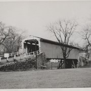
Photograph- Bell Bank covered bridge across the Octoraro Creek four miles south of Nine Points, between Colerain Township, Lancaster County and Upper Oxford Township, Chester County.
Photograph- Bell Bank covered bridge across the Octoraro Creek four miles south of Nine Points, between Colerain Township, Lancaster County and Upper Oxford Township, Chester County.
Description
Bell Bank covered bridge across the Octoraro Creek four miles south of Nine Points, between Colerain Township, Lancaster County and Upper Oxford Township, Chester County.
Provenance
Lancaster County covered bridge photos taken by M. E. Schroll and Kathryn L. Sauder taken between 1956 and 1958.
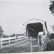
Photograph- End view of Gable's Fording covered bridge across Muddy Creek near Hinkletown, between Ephrata and Earl townships. Bridge no longer standing.
Photograph- End view of Gable's Fording covered bridge across Muddy Creek near Hinkletown, between Ephrata and Earl townships. Bridge no longer standing.
Description
End view of Gable's Fording covered bridge across Muddy Creek near Hinkletown, between Ephrata and Earl townships. Bridge no longer standing.
Provenance
Lancaster County covered bridge photos taken by M. E. Schroll and Kathryn L. Sauder taken between 1956 and 1958.