It appears no script is enabled within your browser. Please enable JavaScript to use this site.
Skip header and navigation
Toggle navigation
Collections
Search
Help
Privacy
Your Selections:
0
Items
Staff Login
Revise Search
Revise Search
Revise search
Search
Data Source
Photographs
10
×
Data Source
All
A
B
C
D
E
F
G
H
I
J
K
L
M
N
O
P
Q
R
S
T
U
V
W
X
Y
Z
Sort
By Count
Alphabetical
Filtered by
Filter
Loading...
Collection
General Collection
8
Covered Bridge Album
2
×
Collection
All
A
B
C
D
E
F
G
H
I
J
K
L
M
N
O
P
Q
R
S
T
U
V
W
X
Y
Z
Sort
By Count
Alphabetical
Filtered by
Filter
Loading...
Subject
Covered bridges
10
Documentary Artifact
9
Bartville, Bart Twp.
5
Conestoga River
5
Octoraro Creek
5
Jackson's Sawmill Covered Bridge
3
Bridges
2
Martindale, Earl Twp.
2
Mills
2
Oberholtzer's Mill
2
Spring Grove, East Earl Twp.
2
1-21-03-35
1
More
×
Subject
All
A
B
C
D
E
F
G
H
I
J
K
L
M
N
O
P
Q
R
S
T
U
V
W
X
Y
Z
Sort
By Count
Alphabetical
Filtered by
Filter
Loading...
Name
Gaintner, Jay Richard
2
Bear, Isaac
1
Bond, G. Ross
1
Bond, George Ross
1
Sensenig, Israel
1
×
Name
All
A
B
C
D
E
F
G
H
I
J
K
L
M
N
O
P
Q
R
S
T
U
V
W
X
Y
Z
Sort
By Count
Alphabetical
Filtered by
Filter
Loading...
Place
Lancaster
36
Manheim Twp.
7
Bart Twp.
East Cocalico Twp.
5
East Earl Twp.
Ephrata Twp.
5
Martic Twp.
5
Caernarvon Twp.
4
West Earl Twp.
4
Colerain Twp.
3
East Hempfield Twp.
3
Eden Twp.
3
More
×
Place
All
A
B
C
D
E
F
G
H
I
J
K
L
M
N
O
P
Q
R
S
T
U
V
W
X
Y
Z
Sort
By Count
Alphabetical
Filtered by
Filter
Loading...
Decade
1900s
1
1920s
2
1950s
1960s
2
1980s
1
1990s
21
2000s
1
×
Decade
All
A
B
C
D
E
F
G
H
I
J
K
L
M
N
O
P
Q
R
S
T
U
V
W
X
Y
Z
Sort
By Count
Alphabetical
Filtered by
Filter
Loading...
Material
Print, Photographic
×
Material
All
A
B
C
D
E
F
G
H
I
J
K
L
M
N
O
P
Q
R
S
T
U
V
W
X
Y
Z
Sort
By Count
Alphabetical
Filtered by
Filter
Loading...
Online Media
Image
10
×
Online Media
All
A
B
C
D
E
F
G
H
I
J
K
L
M
N
O
P
Q
R
S
T
U
V
W
X
Y
Z
Sort
By Count
Alphabetical
Filtered by
Filter
Loading...
Advanced Search
Help
more like: 81D4DBC6-5D4F-4D2D-8C5D-053543664412
1950s
Print, Photographic
Bart Twp.
East Earl Twp.
Sorted by
Relevance
Sort by Title
Expand All
Collapse All
List View
Gallery View
Print
10 records – page 1 of 1.
Prev
Next
Toggle Full Record
Print, Photographic
https://collections.lancasterhistory.org/en/permalink/b625d02f-bc29-4b29-86ba-362736209262
Collection
General Collection
Title
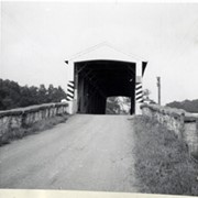
Photograph- View of the bridge on the West Branch of the Octoraro at Jackson's Saw Mill, one mile north of Bartville.
Object ID
1-09-03-25
Date Range
August 4, 1958
More detail
1 image
Object Name
Print, Photographic
Collection
General Collection
Title
Photograph- View of the bridge on the West Branch of the Octoraro at Jackson's Saw Mill, one mile north of Bartville.
Description
View of the bridge on the West Branch of the Octoraro at Jackson's Sawmill, one mile north of Bartville.
Provenance
Lancaster County covered bridge photos taken by M. E. Schroll and Kathryn L. Sauder taken between 1956 and 1958.
Date Range
August 4, 1958
Storage Location
LancasterHistory, Lancaster, PA
Subcategory
Documentary Artifact
Search Terms
Octoraro Creek
Jackson's Sawmill Covered Bridge
Covered bridges
Bartville, Bart Twp.
Place
Bart Twp.
Object Name
Print, Photographic
Print Size
3.5 x 3.5 inches
Condition
Good
Object ID
1-09-03-25
Images
Less detail
More Like This
Permalink
Toggle Full Record
Print, Photographic
https://collections.lancasterhistory.org/en/permalink/39ffc726-b27b-401d-a372-854446508027
Collection
General Collection
Title
Photograph- Octoraro - West Branch, north of Bartville. Jackson's Saw Mill covered bridge.
Object ID
1-09-03-27
Date Range
January 1957
More detail
1 image
Object Name
Print, Photographic
Collection
General Collection
Title
Photograph- Octoraro - West Branch, north of Bartville. Jackson's Saw Mill covered bridge.
Description
Octoraro - West Branch, north of Bartville. Jackson's Saw Mill covered bridge.
Provenance
Lancaster County covered bridge photos taken by M. E. Schroll and Kathryn L. Sauder taken between 1956 and 1958.
Date Range
January 1957
Storage Location
LancasterHistory, Lancaster, PA
Subcategory
Documentary Artifact
Search Terms
Octoraro Creek
Bartville, Bart Twp.
Covered bridges
Place
Bart Twp.
Object Name
Print, Photographic
Print Size
3.5 x 3.5 inches
Condition
Good
Object ID
1-09-03-27
Images
Less detail
More Like This
Permalink
Toggle Full Record
Print, Photographic
https://collections.lancasterhistory.org/en/permalink/b07bff30-a598-46cf-9f83-157463770014
Collection
General Collection
Title
Photograph- Octoraro - West Branch, north of Bartville. Jackson's Saw Mill covered bridge.
Object ID
1-09-03-28
Date Range
January 1957
More detail
1 image
Object Name
Print, Photographic
Collection
General Collection
Title
Photograph- Octoraro - West Branch, north of Bartville. Jackson's Saw Mill covered bridge.
Description
Octoraro - West Branch, north of Bartville. Jackson's Saw Mill covered bridge.
Provenance
Lancaster County covered bridge photos taken by M. E. Schroll and Kathryn L. Sauder taken between 1956 and 1958.
Date Range
January 1957
Storage Location
LancasterHistory, Lancaster, PA
Subcategory
Documentary Artifact
Search Terms
Octoraro Creek
Bartville, Bart Twp.
Covered bridges
Place
Bart Twp.
Object Name
Print, Photographic
Print Size
3.5 x 3.5 inches
Condition
Good
Object ID
1-09-03-28
Images
Less detail
More Like This
Permalink
Toggle Full Record
Print, Photographic
https://collections.lancasterhistory.org/en/permalink/e97b25ce-77d0-4144-b1e7-177420943933
Collection
General Collection
Title
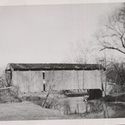
Photograph- Jackson's Saw Mill covered bridge across the West Branch of the Octoraro Creek near Bartville.
Object ID
1-09-03-49
Date Range
September 1956
More detail
1 image
Object Name
Print, Photographic
Collection
General Collection
Title
Photograph- Jackson's Saw Mill covered bridge across the West Branch of the Octoraro Creek near Bartville.
Description
Jackson's Sawmill covered bridge across the West Branch of the Octoraro Creek near Bartville.
Provenance
Lancaster County covered bridge photos taken by M. E. Schroll and Kathryn L. Sauder taken between 1956 and 1958.
Date Range
September 1956
Storage Location
LancasterHistory, Lancaster, PA
Subcategory
Documentary Artifact
Search Terms
Jackson's Sawmill Covered Bridge
Covered bridges
Octoraro Creek
Bartville, Bart Twp.
Place
Bart Twp.
Object Name
Print, Photographic
Print Size
3.5 x 3.5 inches
Condition
Good
Object ID
1-09-03-49
Images
Less detail
More Like This
Permalink
Toggle Full Record
Print, Photographic
https://collections.lancasterhistory.org/en/permalink/ad835665-9cf6-4f91-8e02-564154549419
Collection
General Collection
Title
Photograph- Jackson's Saw Mill covered bridge on the West Branch of the Octoraro Creek, one mile north of Bartville.
Object ID
1-09-03-50
Date Range
August 4, 1958
More detail
1 image
Object Name
Print, Photographic
Collection
General Collection
Title
Photograph- Jackson's Saw Mill covered bridge on the West Branch of the Octoraro Creek, one mile north of Bartville.
Description
Jackson's Sawmill covered bridge on the West Branch of the Octoraro Creek, one mile north of Bartville.
Provenance
Lancaster County covered bridge photos taken by M. E. Schroll and Kathryn L. Sauder taken between 1956 and 1958.
Date Range
August 4, 1958
Storage Location
LancasterHistory, Lancaster, PA
Subcategory
Documentary Artifact
Search Terms
Octoraro Creek
Jackson's Sawmill Covered Bridge
Covered bridges
Bartville, Bart Twp.
Place
Bart Twp.
Object Name
Print, Photographic
Print Size
3.5 x 3.5 inches
Condition
Good
Object ID
1-09-03-50
Images
Less detail
More Like This
Permalink
Toggle Full Record
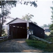
Print, Photographic
https://collections.lancasterhistory.org/en/permalink/88e89a0f-cb50-4753-af99-102674568080
Collection
General Collection
Object ID
1-09-03-73
Date Range
September 5, 1956
More detail
1 image
Object Name
Print, Photographic
Collection
General Collection
Description
Spring Grove covered bridge, also called Overholtzer's Mill covered bridge, on the Conestoga River.
Provenance
Lancaster County covered bridge photos taken by M. E. Schroll and Kathryn L. Sauder taken between 1956 and 1958.
Date Range
September 5, 1956
Storage Location
LancasterHistory, Lancaster, PA
Subcategory
Documentary Artifact
Search Terms
Spring Grove, East Earl Twp.
Covered bridges
Oberholtzer's Mill
Conestoga River
Place
East Earl Twp.
Object Name
Print, Photographic
Print Size
3.5 x 3.5 inches
Condition
Good
Object ID
1-09-03-73
Images
Less detail
More Like This
Permalink
Toggle Full Record
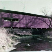
Print, Photographic
https://collections.lancasterhistory.org/en/permalink/5dfb9a8d-37c7-4971-925e-320238909031
Collection
General Collection
Object ID
1-09-03-74
Date Range
August 6, 1958
More detail
1 image
Object Name
Print, Photographic
Collection
General Collection
Description
Spring Grove covered bridge, also called Overholtzer's Mill covered bridge, on the Conestoga River.
Provenance
Lancaster County covered bridge photos taken by M. E. Schroll and Kathryn L. Sauder taken between 1956 and 1958.
Date Range
August 6, 1958
Storage Location
LancasterHistory, Lancaster, PA
Subcategory
Documentary Artifact
Search Terms
Spring Grove, East Earl Twp.
Covered bridges
Oberholtzer's Mill
Conestoga River
Place
East Earl Twp.
Object Name
Print, Photographic
Print Size
3.5 x 3.5 inches
Condition
Good
Object ID
1-09-03-74
Images
Less detail
More Like This
Permalink
Toggle Full Record
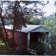
Print, Photographic
https://collections.lancasterhistory.org/en/permalink/4d6838a4-eb73-42db-a007-218848234610
Collection
Covered Bridge Album
Object ID
A-11-01-03
Date Range
1950
More detail
1 image
Object Name
Print, Photographic
Collection
Covered Bridge Album
Description
Israel Sensenig's covered bridge near Martindale in East Earl Township. State supervised on road LR 36013, built 1857, single span 65 feet long.
Date Range
1950
Creator
Gaintner, Jay Richard
Storage Location
LancasterHistory, Lancaster, PA
People
Sensenig, Israel
Subcategory
Documentary Artifact
Search Terms
Bridges
Covered bridges
Mills
Martindale, Earl Twp.
Conestoga River
Place
East Earl Twp.
Object Name
Print, Photographic
Print Size
8 x 10 inches
Object ID
A-11-01-03
Images
Less detail
More Like This
Permalink
Toggle Full Record
Print, Photographic
https://collections.lancasterhistory.org/en/permalink/b04af35f-f309-4205-92da-216891255561
Collection
Covered Bridge Album
Object ID
A-11-01-04
Date Range
1950
More detail
1 image
Object Name
Print, Photographic
Collection
Covered Bridge Album
Description
Isaac Bear's Mill covered bridge, one mile southwest of Martindale in East Earl Township. County maintained on road T-674, built in 1876, single span 94 feet long.
Date Range
1950
Creator
Gaintner, Jay Richard
Storage Location
LancasterHistory, Lancaster, PA
People
Bear, Isaac
Subcategory
Documentary Artifact
Search Terms
Bridges
Covered bridges
Mills
Martindale, Earl Twp.
Conestoga River
Place
East Earl Twp.
Object Name
Print, Photographic
Print Size
8 x 10 inches
Object ID
A-11-01-04
Images
Less detail
More Like This
Permalink
Toggle Full Record
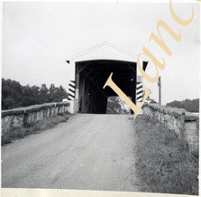
Print, Photographic
https://collections.lancasterhistory.org/en/permalink/e95398c0-909d-4c0e-824e-581690398748
Collection
General Collection
Title
Covered bridge near Goodville
Object ID
1-21-03-35
Date Range
7 November 1958
More detail
1 image
Object Name
Print, Photographic
Collection
General Collection
Title
Covered bridge near Goodville
Description
Covered bridge north of Goodville.
Date Range
7 November 1958
Creator
Bond, George Ross
Storage Location
LancasterHistory, Lancaster, PA
Storage Room
Archives West
People
Bond, G. Ross
Subject
Photographs
Classification
1-21-03-35
Search Terms
Covered bridges
Goodville, East Earl Twp.
Conestoga River
Place
East Earl Twp.
Object Name
Print, Photographic
Original or Copy
Original
Print Size
3.25 x 4.75 inches
Dimention Details
Photograph is glued to black paper
Object ID
1-21-03-35
Credit
Courtesy of LancasterHistory, Lancaster, Pennsylvania
Images
Less detail
More Like This
Permalink
10 records – page 1 of 1.
Prev
Next