It appears no script is enabled within your browser. Please enable JavaScript to use this site.
Skip header and navigation
Toggle navigation
Collections
Search
Help
Privacy
Your Selections:
0
Items
Staff Login
Revise Search
Revise Search
Revise search
Search
Data Source
Photographs
894
×
Data Source
All
A
B
C
D
E
F
G
H
I
J
K
L
M
N
O
P
Q
R
S
T
U
V
W
X
Y
Z
Sort
By Count
Alphabetical
Filtered by
Filter
Loading...
Collection
General Collection
Lloyd E. Eckert Korean War Album
220
Album 82 Donald A. Groff Photograph Album
141
Paul Shaub - United Steel Workers Local 285 Photograph Collection
137
Mildred Shopf Smiley Photograph Collection
110
Ridgeway Travel Photograph Collection
93
James Buchanan Foundation Photograph Collection
89
Sarah Ann Stauffer Photograph Collection
82
William Byron Hornberger Photograph Collection
81
Penn-Mar Auto Racing Association Photograph Collections
68
Lancaster 250 Collection
51
Covered Bridge Album
50
More
×
Collection
All
A
B
C
D
E
F
G
H
I
J
K
L
M
N
O
P
Q
R
S
T
U
V
W
X
Y
Z
Sort
By Count
Alphabetical
Filtered by
Filter
Loading...
Subject
Documentary Artifact
773
Covered bridges
120
Lancaster Jaycees
89
Photographs
72
Baseball
58
Family reunions
56
Lancaster Red Roses
54
Lancaster
48
Hospitals
33
Business
29
Historical markers
29
North Prince Street
27
More
×
Subject
All
A
B
C
D
E
F
G
H
I
J
K
L
M
N
O
P
Q
R
S
T
U
V
W
X
Y
Z
Sort
By Count
Alphabetical
Filtered by
Filter
Loading...
Name
Meyer, Francis E.
47
Bond, George Ross
37
Lockwood, Louis
26
Krone, Herbert
19
Strickler, Daniel B.
17
Bare, Kendig
16
Bond, G. Ross
16
Lancaster Newspapers, Inc.
15
Walter, Ross
15
Hostetter, Harry B.
14
Baker, Marian Louise
13
Gibbs, Edward Lester
13
More
×
Name
All
A
B
C
D
E
F
G
H
I
J
K
L
M
N
O
P
Q
R
S
T
U
V
W
X
Y
Z
Sort
By Count
Alphabetical
Filtered by
Filter
Loading...
Place
Lancaster
276
Carlisle, Cumberland County, Pennsylvania
46
Manheim Twp.
24
Lancaster Twp.
17
Tokyo, Japan
13
Manor Twp.
11
Rapho Twp.
10
East Hempfield Twp.
8
Ephrata Twp.
8
Bart Twp.
7
East Earl Twp.
7
East Donegal Twp.
6
More
×
Place
All
A
B
C
D
E
F
G
H
I
J
K
L
M
N
O
P
Q
R
S
T
U
V
W
X
Y
Z
Sort
By Count
Alphabetical
Filtered by
Filter
Loading...
Decade
1070s
1
1740s
1
1800s
3
1840s
5
1850s
39
1860s
181
1870s
107
1880s
157
1890s
329
1900s
537
1910s
915
1920s
1143
1930s
840
1940s
674
1950s
1960s
1116
1970s
1352
1980s
621
1990s
1102
2000s
982
2010s
13
×
Decade
All
A
B
C
D
E
F
G
H
I
J
K
L
M
N
O
P
Q
R
S
T
U
V
W
X
Y
Z
Sort
By Count
Alphabetical
Filtered by
Filter
Loading...
Material
Print, Photographic
890
Negative
3
Transparency, Slide
1
×
Material
All
A
B
C
D
E
F
G
H
I
J
K
L
M
N
O
P
Q
R
S
T
U
V
W
X
Y
Z
Sort
By Count
Alphabetical
Filtered by
Filter
Loading...
Online Media
Image
×
Online Media
All
A
B
C
D
E
F
G
H
I
J
K
L
M
N
O
P
Q
R
S
T
U
V
W
X
Y
Z
Sort
By Count
Alphabetical
Filtered by
Filter
Loading...
Advanced Search
Help
more like: 97BCC5EC-6948-4224-81F7-254747357916
1950s
Image
General Collection
Sorted by
Relevance
Sort by Title
Expand All
Collapse All
List View
Gallery View
Print
10 records – page 1 of 1.
Prev
Next
Toggle Full Record
Print, Photographic
https://collections.lancasterhistory.org/en/permalink/442ff0fa-01b1-4b5b-9284-146530402130
Collection
General Collection
Title
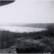
Photograph- View from Chickies Rock looking toward Wrightsville.
Object ID
1-04-05-90
Date Range
December 26, 1955
More detail
1 image
Object Name
Print, Photographic
Collection
General Collection
Title
Photograph- View from Chickies Rock looking toward Wrightsville.
Description
View from Chickies Rock looking toward Wrightsville.
Provenance
From the collections of M. Luther Heisey.
Date Range
December 26, 1955
Storage Location
LancasterHistory, Lancaster, PA
Subcategory
Documentary Artifact
Search Terms
Susquehanna River
Chickies Rock
Place
East Donegal Twp.
Object Name
Print, Photographic
Print Size
3.5 x 3.5 inches
Condition
Good
Object ID
1-04-05-90
Images
Less detail
More Like This
Permalink
Toggle Full Record
Print, Photographic
https://collections.lancasterhistory.org/en/permalink/9d642ffd-c144-4600-a0b7-134338382090
Collection
General Collection
Title
Photograph- View from Chickies Rock looking toward Wrightsville.
Object ID
1-04-05-91
Date Range
December 26, 1955
More detail
1 image
Object Name
Print, Photographic
Collection
General Collection
Title
Photograph- View from Chickies Rock looking toward Wrightsville.
Description
View from Chickies Rock looking toward Wrightsville.
Provenance
From the collections of M. Luther Heisey.
Date Range
December 26, 1955
Storage Location
LancasterHistory, Lancaster, PA
Subcategory
Documentary Artifact
Search Terms
Susquehanna River
Chickies Rock
Place
East Donegal Twp.
Object Name
Print, Photographic
Print Size
3.5 x 3.5 inches
Condition
Good
Object ID
1-04-05-91
Images
Less detail
More Like This
Permalink
Toggle Full Record
Print, Photographic
https://collections.lancasterhistory.org/en/permalink/68f1a608-cf5b-4ae3-8570-357683395060
Collection
General Collection
Title
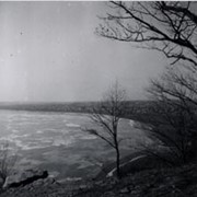
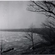
Photograph- View from Chickies Rock looking toward Marietta.
Object ID
1-04-05-92
Date Range
December 26, 1955
More detail
1 image
Object Name
Print, Photographic
Collection
General Collection
Title
Photograph- View from Chickies Rock looking toward Marietta.
Description
View from Chickies Rock looking toward Marietta.
Provenance
From the collections of M. Luther Heisey.
Date Range
December 26, 1955
Storage Location
LancasterHistory, Lancaster, PA
Subcategory
Documentary Artifact
Search Terms
Susquehanna River
Chickies Rock
Place
East Donegal Twp.
Object Name
Print, Photographic
Print Size
3.5 x 3.5 inches
Condition
Good
Object ID
1-04-05-92
Images
Less detail
More Like This
Permalink
Toggle Full Record
Print, Photographic
https://collections.lancasterhistory.org/en/permalink/879de0d2-59d8-4faf-b431-018730120541
Collection
General Collection
Title
Photograph- View from Chickies Rock looking toward Marietta.
Object ID
1-04-05-93
Date Range
December 26, 1955
More detail
1 image
Object Name
Print, Photographic
Collection
General Collection
Title
Photograph- View from Chickies Rock looking toward Marietta.
Description
View from Chickies Rock looking toward Marietta.
Provenance
From the collections of M. Luther Heisey.
Date Range
December 26, 1955
Storage Location
LancasterHistory, Lancaster, PA
Subcategory
Documentary Artifact
Search Terms
Susquehanna River
Chickies Rock
Place
East Donegal Twp.
Object Name
Print, Photographic
Print Size
3.5 x 3.5 inches
Condition
Good
Object ID
1-04-05-93
Images
Less detail
More Like This
Permalink
Toggle Full Record
Print, Photographic
https://collections.lancasterhistory.org/en/permalink/bb6902f8-d8a1-46ea-a082-372905215574
Collection
General Collection
Title
Historical marker for Rock Ford
Object ID
1-21-06-77
More detail
1 image
Object Name
Print, Photographic
Collection
General Collection
Title
Historical marker for Rock Ford
Description
Pennsylvaia Historical and Museum Commission marker Rock Ford, home of General Edward Hand. Located near the Conestoga River.
Year Range From
1950
Year Range To
1959
Creator
Lockwood, Louis
Storage Location
LancasterHistory, Lancaster, PA
Storage Room
Archives West
People
Hand, Edward
Subject
Photographs
Classification
1-21-06-77
Search Terms
Historical markers
Rock Ford
Conestoga River
Place
Lancaster Twp.
Object Name
Print, Photographic
Original or Copy
Original
Print Size
3.5 x 5 inches
Object ID
1-21-06-77
Credit
Courtesy of LancasterHistory, Lancaster, Pennsylvania
Accession Number
2023.Lockwood
Images
Less detail
More Like This
Permalink
Toggle Full Record
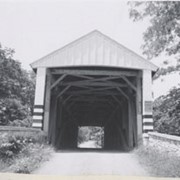
Print, Photographic
https://collections.lancasterhistory.org/en/permalink/adf748a2-38eb-4fbc-9b00-493564116246
Collection
General Collection
Title
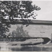
Photograph- White Rock covered bridge over the West Branch of the Octoraro Creek between Colerain and Little Britain townships.
Object ID
1-09-03-53
Date Range
September 1956
More detail
1 image
Object Name
Print, Photographic
Collection
General Collection
Title
Photograph- White Rock covered bridge over the West Branch of the Octoraro Creek between Colerain and Little Britain townships.
Description
White Rock covered bridge over the West Branch of the Octoraro Creek between Colerain and Little Britain townships.
Provenance
Lancaster County covered bridge photos taken by M. E. Schroll and Kathryn L. Sauder taken between 1956 and 1958.
Date Range
September 1956
Storage Location
LancasterHistory, Lancaster, PA
Subcategory
Documentary Artifact
Search Terms
Bridges
Colerain Twp.
Covered bridges
Creeks
Octoraro Creek, West Branch
White Rock Covered Bridge
White Rock Forge Covered Bridge
White Rock, Little Britain Twp.
Object Name
Print, Photographic
Print Size
3.5 x 3.5 inches
Condition
Good
Object ID
1-09-03-53
Images
Less detail
More Like This
Permalink
Toggle Full Record
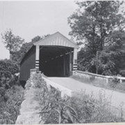
Print, Photographic
https://collections.lancasterhistory.org/en/permalink/aee09825-bd3d-4c64-85d9-210349253712
Collection
General Collection
Title
Photograph- White Rock covered bridge over the West Branch of the Octoraro Creek between Colerain and Little Britain townships.
Object ID
1-09-03-54
Date Range
August 4, 1958
More detail
1 image
Object Name
Print, Photographic
Collection
General Collection
Title
Photograph- White Rock covered bridge over the West Branch of the Octoraro Creek between Colerain and Little Britain townships.
Description
White Rock covered bridge over the West Branch of the Octoraro Creek between Colerain and Little Britain townships.
Provenance
Lancaster County covered bridge photos taken by M. E. Schroll and Kathryn L. Sauder taken between 1956 and 1958.
Date Range
August 4, 1958
Storage Location
LancasterHistory, Lancaster, PA
Subcategory
Documentary Artifact
Search Terms
Bridges
Colerain Twp.
Covered bridges
Creeks
Octoraro Creek, West Branch
White Rock Covered Bridge
White Rock Forge Covered Bridge
White Rock, Little Britain Twp.
Object Name
Print, Photographic
Print Size
3.5 x 3.5 inches
Condition
Good
Object ID
1-09-03-54
Images
Less detail
More Like This
Permalink
Toggle Full Record
Print, Photographic
https://collections.lancasterhistory.org/en/permalink/296c6673-3a37-4258-bea2-449609487490
Collection
General Collection
Title
Photograph- Side view of King's Bridge on the West Branch of the Octoraro northwest of White Rock, between Colerain and Little Britain townships.
Object ID
1-09-03-51
Date Range
September 1, 1958
More detail
1 image
Object Name
Print, Photographic
Collection
General Collection
Title
Photograph- Side view of King's Bridge on the West Branch of the Octoraro northwest of White Rock, between Colerain and Little Britain townships.
Description
Side view of King's Bridge on the West Branch of the Octoraro northwest of White Rock, between Colerain and Little Britain townships.
Provenance
Lancaster County covered bridge photos taken by M. E. Schroll and Kathryn L. Sauder taken between 1956 and 1958.
Date Range
September 1, 1958
Storage Location
LancasterHistory, Lancaster, PA
Subcategory
Documentary Artifact
Search Terms
Bridges
King's Bridge
Covered bridges
Octoraro Creek, West Branch
White Rock, Little Britain Twp.
Creeks
Object Name
Print, Photographic
Print Size
3.5 x 3.5 inches
Condition
Good
Object ID
1-09-03-51
Images
Less detail
More Like This
Permalink
Toggle Full Record
Print, Photographic
https://collections.lancasterhistory.org/en/permalink/ac7b4f34-8612-46a0-9a19-171450654357
Collection
General Collection
Title
Photograph- Siegrist's Mill covered bridge on the Big Chiques Creek southeast of Newtown.
Object ID
1-09-03-38
Date Range
June 1956
More detail
1 image
Object Name
Print, Photographic
Collection
General Collection
Title
Photograph- Siegrist's Mill covered bridge on the Big Chiques Creek southeast of Newtown.
Description
Siegrist's Mill covered bridge on the Big Chiques Creek southeast of Newtown.
Provenance
Lancaster County covered bridge photos taken by M. E. Schroll and Kathryn L. Sauder taken between 1956 and 1958.
Date Range
June 1956
Storage Location
LancasterHistory, Lancaster, PA
Subcategory
Documentary Artifact
Search Terms
Siegrist's Mill
Covered bridges
Chiques Creek
Newtown, Rapho Twp.
Chickies Creek
Place
Rapho Twp.
Object Name
Print, Photographic
Print Size
3.5 x 3.5 inches
Condition
Good
Object ID
1-09-03-38
Images
Less detail
More Like This
Permalink
Toggle Full Record
Print, Photographic
https://collections.lancasterhistory.org/en/permalink/304cc0f5-02ce-4c10-8198-756258749128
Collection
General Collection
Title
Photograph- Siegrist's Mill covered bridge across the Big Chiques Creek, southeast of Newtown.
Object ID
1-09-03-39
Date Range
June 1956
More detail
1 image
Object Name
Print, Photographic
Collection
General Collection
Title
Photograph- Siegrist's Mill covered bridge across the Big Chiques Creek, southeast of Newtown.
Description
Siegrist's Mill covered bridge across the Big Chiques Creek, southeast of Newtown.
Provenance
Lancaster County covered bridge photos taken by M. E. Schroll and Kathryn L. Sauder taken between 1956 and 1958.
Date Range
June 1956
Storage Location
LancasterHistory, Lancaster, PA
Subcategory
Documentary Artifact
Search Terms
Siegrist's Mill
Covered bridges
Chiques Creek
Newtown, Rapho Twp.
Rapho Twp.
Chickies Creek
Place
Rapho Twp.
Object Name
Print, Photographic
Print Size
3.5 x 3.5 inches
Condition
Good
Object ID
1-09-03-39
Images
Less detail
More Like This
Permalink
10 records – page 1 of 1.
Prev
Next