It appears no script is enabled within your browser. Please enable JavaScript to use this site.
Skip header and navigation
Toggle navigation
Collections
Search
Help
Privacy
Your Selections:
0
Items
Staff Login
Revise Search
Revise Search
Revise search
Search
Data Source
Photographs
185
×
Data Source
All
A
B
C
D
E
F
G
H
I
J
K
L
M
N
O
P
Q
R
S
T
U
V
W
X
Y
Z
Sort
By Count
Alphabetical
Filtered by
Filter
Loading...
Collection
General Collection
141
Covered Bridge Album
21
Mildred Shopf Smiley Photograph Collection
16
Album 82 Donald A. Groff Photograph Album
4
Lancaster 250 Collection
1
Railroad Album
1
Sarah Darmstaetter Collection
1
×
Collection
All
A
B
C
D
E
F
G
H
I
J
K
L
M
N
O
P
Q
R
S
T
U
V
W
X
Y
Z
Sort
By Count
Alphabetical
Filtered by
Filter
Loading...
Subject
Documentary Artifact
158
Covered bridges
122
Bridges
32
Conestoga River
29
Mills
20
Pequea Creek
18
Photographs
17
Big Chickies Creek
14
Big Chiques Creek
14
Creeks
10
Mill Creek Trailer Park
10
Newtown, Rapho Twp.
10
More
×
Subject
All
A
B
C
D
E
F
G
H
I
J
K
L
M
N
O
P
Q
R
S
T
U
V
W
X
Y
Z
Sort
By Count
Alphabetical
Filtered by
Filter
Loading...
Name
Gaintner, Jay Richard
21
Bond, George Ross
14
Bond, G. Ross
9
Strickler, Daniel B.
8
Lemnitzer, L. L.
5
Smiley, Mildred Shopf
5
Lockwood, Louis
4
Helgeson, B. C., SP/3
3
Bard, Guy
2
Barnes, Earl W.
2
Caraway, Paul W.
2
Hendrick, Pvt. John H.
2
More
×
Name
All
A
B
C
D
E
F
G
H
I
J
K
L
M
N
O
P
Q
R
S
T
U
V
W
X
Y
Z
Sort
By Count
Alphabetical
Filtered by
Filter
Loading...
Place
Lancaster
12
Ephrata Twp.
8
Manheim Twp.
8
Tokyo, Japan
8
East Earl Twp.
7
Martic Twp.
6
Bart Twp.
5
East Cocalico Twp.
5
West Earl Twp.
5
Caernarvon Twp.
4
Earl Twp.
4
East Hempfield Twp.
4
More
×
Place
All
A
B
C
D
E
F
G
H
I
J
K
L
M
N
O
P
Q
R
S
T
U
V
W
X
Y
Z
Sort
By Count
Alphabetical
Filtered by
Filter
Loading...
Decade
1850s
2
1860s
6
1870s
8
1880s
12
1890s
48
1900s
90
1910s
77
1920s
198
1930s
115
1940s
84
1950s
1960s
126
1970s
118
1980s
309
1990s
205
2000s
216
2010s
2
×
Decade
All
A
B
C
D
E
F
G
H
I
J
K
L
M
N
O
P
Q
R
S
T
U
V
W
X
Y
Z
Sort
By Count
Alphabetical
Filtered by
Filter
Loading...
Material
Print, Photographic
Negative
33
Slide
8
Transparency, Slide
8
Negative, Roll Film
3
Print
2
×
Material
All
A
B
C
D
E
F
G
H
I
J
K
L
M
N
O
P
Q
R
S
T
U
V
W
X
Y
Z
Sort
By Count
Alphabetical
Filtered by
Filter
Loading...
Online Media
Image
×
Online Media
All
A
B
C
D
E
F
G
H
I
J
K
L
M
N
O
P
Q
R
S
T
U
V
W
X
Y
Z
Sort
By Count
Alphabetical
Filtered by
Filter
Loading...
Advanced Search
Help
more like: 98675E09-7D9D-4543-A0F7-141919502000
1950s
Print, Photographic
Image
Sorted by
Relevance
Sort by Title
Expand All
Collapse All
List View
Gallery View
Print
10 records – page 1 of 1.
Prev
Next
Toggle Full Record
Print, Photographic
https://collections.lancasterhistory.org/en/permalink/b4415182-3743-4f3b-a3c6-718845529642
Collection
General Collection
Object ID
2-21-01-03
Date Range
October 20, 1958
More detail
1 image
Object Name
Print, Photographic
Collection
General Collection
Description
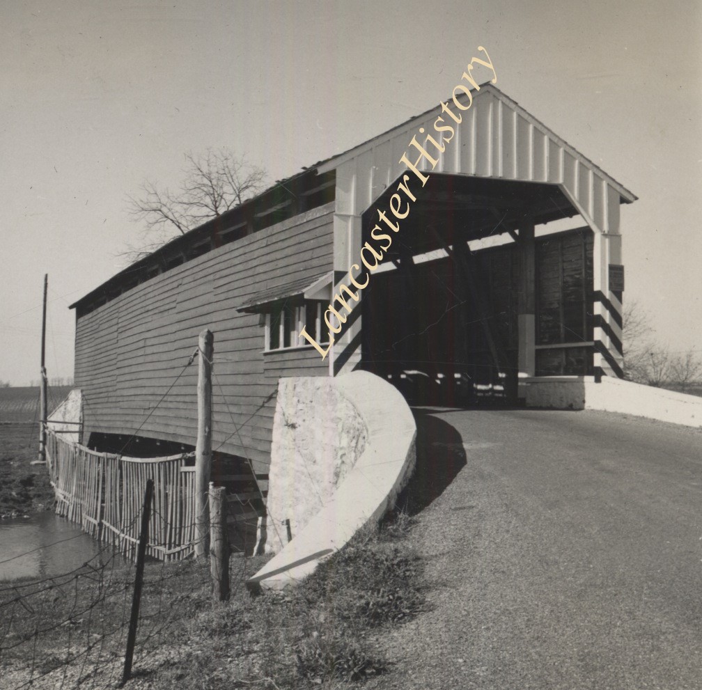
Covered Bridge north of Landisville
Provenance
Donated by Deanna M. Nolder.
Loose pages from photo album belonging to donor's late grandfather, G.Ross Bond of York, PA.
Date Range
October 20, 1958
Creator
Bond, George Ross
Storage Location
LancasterHistory, Lancaster, PA
Subcategory
Documentary Artifact
Search Terms
Landisville, East Hempfield Twp.
Covered bridges
Object Name
Print, Photographic
Print Size
3.5 x 3.5 inches
Condition
Good
Object ID
2-21-01-03
Images
Less detail
More Like This
Permalink
Toggle Full Record
Print, Photographic
https://collections.lancasterhistory.org/en/permalink/53929494-68a1-41e5-a964-760230605236
Collection
General Collection
Object ID
1-09-04-08
Date Range
July 1956
More detail
1 image
Object Name
Print, Photographic
Collection
General Collection
Description
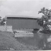
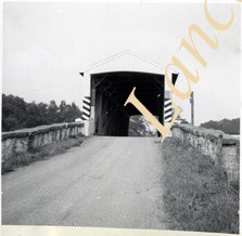
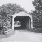
Covered bridge on the Little Conestoga Creek, a short distance north of Oreville.
Provenance
Lancaster County covered bridge photos taken by M. E. Schroll and Kathryn L. Sauder taken between 1956 and 1958.
Date Range
July 1956
Storage Location
LancasterHistory, Lancaster, PA
Subcategory
Documentary Artifact
Search Terms
Oreville, East Hempfield Twp.
Little Conestoga Creek
Covered bridges
Place
East Hempfield Twp.
Object Name
Print, Photographic
Print Size
3.5 x 4.5 inches
Condition
Good
Object ID
1-09-04-08
Images
Less detail
More Like This
Permalink
Toggle Full Record
Print, Photographic
https://collections.lancasterhistory.org/en/permalink/657f51b7-1efa-45ed-86f6-005559072076
Collection
General Collection
Object ID
1-09-04-09
Date Range
August 12, 1958
More detail
1 image
Object Name
Print, Photographic
Collection
General Collection
Description
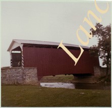
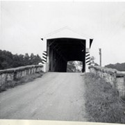
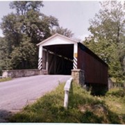
Covered bridge on the Little Conestoga Creek north of Oreville.
Provenance
Lancaster County covered bridge photos taken by M. E. Schroll and Kathryn L. Sauder taken between 1956 and 1958.
Date Range
August 12, 1958
Storage Location
LancasterHistory, Lancaster, PA
Subcategory
Documentary Artifact
Search Terms
Covered bridges
Little Conestoga Creek
Oreville, East Hempfield Twp.
Place
East Hempfield Twp.
Object Name
Print, Photographic
Print Size
3.5 x 4.5 inches
Condition
Good
Object ID
1-09-04-09
Images
Less detail
More Like This
Permalink
Toggle Full Record
Print, Photographic
https://collections.lancasterhistory.org/en/permalink/0d1a3d01-ea5f-45e8-a641-746398347640
Collection
General Collection
Title
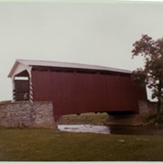
Photograph- Interior of covered bridge at Oreville on the Little Conestoga Creek.
Object ID
1-09-03-37
Date Range
July 1956
More detail
1 image
Object Name
Print, Photographic
Collection
General Collection
Title
Photograph- Interior of covered bridge at Oreville on the Little Conestoga Creek.
Description
Interior of covered bridge at Oreville on the Little Conestoga Creek.
Provenance
Lancaster County covered bridge photos taken by M. E. Schroll and Kathryn L. Sauder taken between 1956 and 1958.
Date Range
July 1956
Storage Location
LancasterHistory, Lancaster, PA
Subcategory
Documentary Artifact
Search Terms
Covered bridges
Oreville, East Hempfield Twp.
Conestoga Creek
Place
East Hempfield Twp.
Object Name
Print, Photographic
Print Size
3.5 x 3.5 inches
Condition
Good
Object ID
1-09-03-37
Images
Less detail
More Like This
Permalink
Toggle Full Record
Print, Photographic
https://collections.lancasterhistory.org/en/permalink/88e89a0f-cb50-4753-af99-102674568080
Collection
General Collection
Object ID
1-09-03-73
Date Range
September 5, 1956
More detail
1 image
Object Name
Print, Photographic
Collection
General Collection
Description
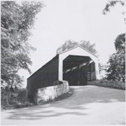
Spring Grove covered bridge, also called Overholtzer's Mill covered bridge, on the Conestoga River.
Provenance
Lancaster County covered bridge photos taken by M. E. Schroll and Kathryn L. Sauder taken between 1956 and 1958.
Date Range
September 5, 1956
Storage Location
LancasterHistory, Lancaster, PA
Subcategory
Documentary Artifact
Search Terms
Spring Grove, East Earl Twp.
Covered bridges
Oberholtzer's Mill
Conestoga River
Place
East Earl Twp.
Object Name
Print, Photographic
Print Size
3.5 x 3.5 inches
Condition
Good
Object ID
1-09-03-73
Images
Less detail
More Like This
Permalink
Toggle Full Record
Print, Photographic
https://collections.lancasterhistory.org/en/permalink/5dfb9a8d-37c7-4971-925e-320238909031
Collection
General Collection
Object ID
1-09-03-74
Date Range
August 6, 1958
More detail
1 image
Object Name
Print, Photographic
Collection
General Collection
Description
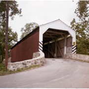
Spring Grove covered bridge, also called Overholtzer's Mill covered bridge, on the Conestoga River.
Provenance
Lancaster County covered bridge photos taken by M. E. Schroll and Kathryn L. Sauder taken between 1956 and 1958.
Date Range
August 6, 1958
Storage Location
LancasterHistory, Lancaster, PA
Subcategory
Documentary Artifact
Search Terms
Spring Grove, East Earl Twp.
Covered bridges
Oberholtzer's Mill
Conestoga River
Place
East Earl Twp.
Object Name
Print, Photographic
Print Size
3.5 x 3.5 inches
Condition
Good
Object ID
1-09-03-74
Images
Less detail
More Like This
Permalink
Toggle Full Record
Print, Photographic
https://collections.lancasterhistory.org/en/permalink/b96d083f-bd84-4520-8889-425317504749
Collection
General Collection
Object ID
1-09-03-95
Date Range
August 1956
More detail
1 image
Object Name
Print, Photographic
Collection
General Collection
Description
Fry's Mill Covered Bridge on Muddy Creek south of Napierville.
Provenance
Lancaster County covered bridge photos taken by M. E. Schroll and Kathryn L. Sauder taken between 1956 and 1958.
Date Range
August 1956
Storage Location
LancasterHistory, Lancaster, PA
Subcategory
Documentary Artifact
Search Terms
Fry's Mill Covered Bridge
Covered bridges
Muddy Creek
Napierville, East Cocalico Twp.
Place
East Cocalico Twp.
Object Name
Print, Photographic
Print Size
3.5 x 3.5 inches
Condition
Good
Object ID
1-09-03-95
Images
Less detail
More Like This
Permalink
Toggle Full Record
Print, Photographic
https://collections.lancasterhistory.org/en/permalink/b73340d6-40d2-4627-a18c-041821357277
Collection
General Collection
Object ID
1-09-03-96
Date Range
August 7, 1958
More detail
1 image
Object Name
Print, Photographic
Collection
General Collection
Description
Fry's Covered Bridge near Napierville.
Provenance
Lancaster County covered bridge photos taken by M. E. Schroll and Kathryn L. Sauder taken between 1956 and 1958.
Date Range
August 7, 1958
Storage Location
LancasterHistory, Lancaster, PA
Subcategory
Documentary Artifact
Search Terms
Fry's Mill Covered Bridge
Napierville, East Cocalico Twp.
Covered bridges
Place
East Cocalico Twp.
Object Name
Print, Photographic
Print Size
3.5 x 3.5 inches
Condition
Good
Object ID
1-09-03-96
Images
Less detail
More Like This
Permalink
Toggle Full Record
Print, Photographic
https://collections.lancasterhistory.org/en/permalink/458b6e7d-9d80-4cee-bc15-208141417154
Collection
General Collection
Object ID
1-09-03-97
Date Range
September 1956
More detail
1 image
Object Name
Print, Photographic
Collection
General Collection
Description
Possibly Bucher's Mill Covered Bridge on the Cocalico Creek west of Reamstown.
Provenance
Lancaster County covered bridge photos taken by M. E. Schroll and Kathryn L. Sauder taken between 1956 and 1958.
Date Range
September 1956
Storage Location
LancasterHistory, Lancaster, PA
Subcategory
Documentary Artifact
Search Terms
Bucher's Mill
Covered bridges
Cocalico Creek
Reamstown, East Cocalico Twp.
Place
East Cocalico Twp.
Object Name
Print, Photographic
Print Size
3.5 x 3.5 inches
Condition
Good
Object ID
1-09-03-97
Images
Less detail
More Like This
Permalink
Toggle Full Record
Print, Photographic
https://collections.lancasterhistory.org/en/permalink/97d6f671-ca87-4aa9-9583-912283397296
Collection
General Collection
Object ID
1-09-03-98
Date Range
August 4, 1958
More detail
1 image
Object Name
Print, Photographic
Collection
General Collection
Description
Possibly Bucher's Mill covered bridge on the Cocalico Creek west of Reamstown and east of Ephrata.
Provenance
Lancaster County covered bridge photos taken by M. E. Schroll and Kathryn L. Sauder taken between 1956 and 1958.
Date Range
August 4, 1958
Storage Location
LancasterHistory, Lancaster, PA
Subcategory
Documentary Artifact
Search Terms
Bucher's Mill
Covered bridges
Cocalico Creek
Reamstown, East Cocalico Twp.
Place
East Cocalico Twp.
Object Name
Print, Photographic
Print Size
3.5 x 3.5 inches
Condition
Good
Object ID
1-09-03-98
Images
Less detail
More Like This
Permalink
10 records – page 1 of 1.
Prev
Next