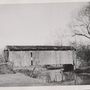
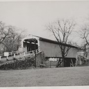
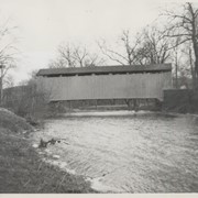
Photograph- Bell Bank covered bridge across the Octoraro Creek four miles south of Nine Points, between Colerain Township, Lancaster County and Upper Oxford Township, Chester County.
Photograph- Bell Bank covered bridge across the Octoraro Creek four miles south of Nine Points, between Colerain Township, Lancaster County and Upper Oxford Township, Chester County.
Description
Bell Bank covered bridge across the Octoraro Creek four miles south of Nine Points, between Colerain Township, Lancaster County and Upper Oxford Township, Chester County.
Provenance
Lancaster County covered bridge photos taken by M. E. Schroll and Kathryn L. Sauder taken between 1956 and 1958.
Isaac Bear's Mill covered bridge, one mile southwest of Martindale in East Earl Township. County maintained on road T-674, built in 1876, single span 94 feet long.
Gable's Fording, one mile northeast of Hinkletown, near confluence with Conestoga River, between Earl and Ephrata Townships. State supervised on road LR 36052, built in 1872, single span 129 feet long.
Bucher's Mill, .5 mile west of Reamstown in East Cocalico Township. County maintained on road T-955 just off Route 222, built in 1881, single span 60 feet long.