It appears no script is enabled within your browser. Please enable JavaScript to use this site.
Skip header and navigation
Toggle navigation
Collections
Search
Help
Privacy
Your Selections:
0
Items
Staff Login
Revise Search
Revise Search
Revise search
Search
Data Source
Photographs
165
×
Data Source
All
A
B
C
D
E
F
G
H
I
J
K
L
M
N
O
P
Q
R
S
T
U
V
W
X
Y
Z
Sort
By Count
Alphabetical
Filtered by
Filter
Loading...
Collection
General Collection
Covered Bridge Album
21
Album 82 Donald A. Groff Photograph Album
4
Mildred Shopf Smiley Photograph Collection
4
Scrapbook Collection
3
Lancaster 250 Collection
2
Adam Reigart Jr., John S. Murphy Collection
1
Advertising and Promotional Collection
1
Andrew B. Rote Collection
1
Auto Racing Collection
1
Daniel Reiber Collection
1
Diffenderffer Family Papers
1
More
×
Collection
All
A
B
C
D
E
F
G
H
I
J
K
L
M
N
O
P
Q
R
S
T
U
V
W
X
Y
Z
Sort
By Count
Alphabetical
Filtered by
Filter
Loading...
Subject
Documentary Artifact
138
Covered bridges
87
Conestoga River
19
West King Street
19
North Prince Street
14
Pequea Creek
14
Bridges
12
Stores
12
Big Chickies Creek
10
Big Chiques Creek
10
Creeks
10
Abbeville, Lancaster Twp.
9
More
×
Subject
All
A
B
C
D
E
F
G
H
I
J
K
L
M
N
O
P
Q
R
S
T
U
V
W
X
Y
Z
Sort
By Count
Alphabetical
Filtered by
Filter
Loading...
Name
Bond, George Ross
11
Walter, Ross
8
Harper, Ray
5
Bond, G. Ross
4
Lockwood, Louis
3
Courson, Ada
2
Mann, George
2
Beck, Herbert
1
Bender, Charles M.
1
Chambers, David F.
1
Courson, Howard
1
Heisey, Martin Luther
1
More
×
Name
All
A
B
C
D
E
F
G
H
I
J
K
L
M
N
O
P
Q
R
S
T
U
V
W
X
Y
Z
Sort
By Count
Alphabetical
Filtered by
Filter
Loading...
Place
Lancaster
34
Lancaster Twp.
9
East Cocalico Twp.
6
Manheim Twp.
6
Bart Twp.
5
East Hempfield Twp.
5
East Donegal Twp.
4
Elizabeth Twp.
4
Ephrata Twp.
4
West Earl Twp.
4
East Earl Twp.
3
Eden Twp.
3
More
×
Place
All
A
B
C
D
E
F
G
H
I
J
K
L
M
N
O
P
Q
R
S
T
U
V
W
X
Y
Z
Sort
By Count
Alphabetical
Filtered by
Filter
Loading...
Decade
1740s
1
1780s
1
1790s
19
1800s
25
1810s
50
1820s
60
1830s
63
1840s
115
1850s
103
1860s
99
1870s
84
1880s
135
1890s
141
1900s
123
1910s
179
1920s
129
1930s
66
1940s
39
1950s
1960s
107
1970s
197
1980s
13
1990s
207
2000s
159
2010s
2
×
Decade
All
A
B
C
D
E
F
G
H
I
J
K
L
M
N
O
P
Q
R
S
T
U
V
W
X
Y
Z
Sort
By Count
Alphabetical
Filtered by
Filter
Loading...
Material
Print, Photographic
146
Transparency, Slide
11
Slide
8
×
Material
All
A
B
C
D
E
F
G
H
I
J
K
L
M
N
O
P
Q
R
S
T
U
V
W
X
Y
Z
Sort
By Count
Alphabetical
Filtered by
Filter
Loading...
Online Media
Image
165
×
Online Media
All
A
B
C
D
E
F
G
H
I
J
K
L
M
N
O
P
Q
R
S
T
U
V
W
X
Y
Z
Sort
By Count
Alphabetical
Filtered by
Filter
Loading...
Advanced Search
Help
more like: EA3B466E-DE49-44EE-96C0-105037314954
1950s
Bridge Records
General Collection
Slaymaker Family Photograph Collection
Sorted by
Relevance
Sort by Title
Expand All
Collapse All
List View
Gallery View
Print
10 records – page 1 of 1.
Prev
Next
Toggle Full Record
Print, Photographic
https://collections.lancasterhistory.org/en/permalink/4bbec65e-0210-44c9-9eec-452372049972
Collection
General Collection
Object ID
1-09-04-03
Date Range
August 5, 1958
More detail
1 image
Object Name
Print, Photographic
Collection
General Collection
Description
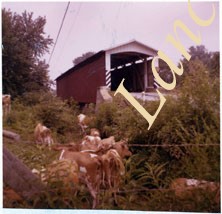
Zook's Mill covered bridge on the Cocalico Creek on Log Cabin Road west of Brownstown between West Earl and Warwick townships.
Provenance
Lancaster County covered bridge photos taken by M. E. Schroll and Kathryn L. Sauder taken between 1956 and 1958.
Date Range
August 5, 1958
Storage Location
LancasterHistory, Lancaster, PA
Subcategory
Documentary Artifact
Search Terms
Bridges
Brownstown, West Earl Twp.
Cocalico Creek
Covered bridges
Creeks
Log Cabin Road
Rose Hill Bridge
Warwick Twp.
West Earl Twp.
Zook's Mill
Object Name
Print, Photographic
Print Size
3.5 x 4.5 inches
Condition
Good
Object ID
1-09-04-03
Images
Less detail
More Like This
Permalink
Toggle Full Record
Print, Photographic
https://collections.lancasterhistory.org/en/permalink/adf748a2-38eb-4fbc-9b00-493564116246
Collection
General Collection
Title
Photograph- White Rock covered bridge over the West Branch of the Octoraro Creek between Colerain and Little Britain townships.
Object ID
1-09-03-53
Date Range
September 1956
More detail
1 image
Object Name
Print, Photographic
Collection
General Collection
Title
Photograph- White Rock covered bridge over the West Branch of the Octoraro Creek between Colerain and Little Britain townships.
Description
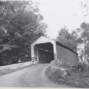
White Rock covered bridge over the West Branch of the Octoraro Creek between Colerain and Little Britain townships.
Provenance
Lancaster County covered bridge photos taken by M. E. Schroll and Kathryn L. Sauder taken between 1956 and 1958.
Date Range
September 1956
Storage Location
LancasterHistory, Lancaster, PA
Subcategory
Documentary Artifact
Search Terms
Bridges
Colerain Twp.
Covered bridges
Creeks
Octoraro Creek, West Branch
White Rock Covered Bridge
White Rock Forge Covered Bridge
White Rock, Little Britain Twp.
Object Name
Print, Photographic
Print Size
3.5 x 3.5 inches
Condition
Good
Object ID
1-09-03-53
Images
Less detail
More Like This
Permalink
Toggle Full Record
Print, Photographic
https://collections.lancasterhistory.org/en/permalink/aee09825-bd3d-4c64-85d9-210349253712
Collection
General Collection
Title
Photograph- White Rock covered bridge over the West Branch of the Octoraro Creek between Colerain and Little Britain townships.
Object ID
1-09-03-54
Date Range
August 4, 1958
More detail
1 image
Object Name
Print, Photographic
Collection
General Collection
Title
Photograph- White Rock covered bridge over the West Branch of the Octoraro Creek between Colerain and Little Britain townships.
Description
White Rock covered bridge over the West Branch of the Octoraro Creek between Colerain and Little Britain townships.
Provenance
Lancaster County covered bridge photos taken by M. E. Schroll and Kathryn L. Sauder taken between 1956 and 1958.
Date Range
August 4, 1958
Storage Location
LancasterHistory, Lancaster, PA
Subcategory
Documentary Artifact
Search Terms
Bridges
Colerain Twp.
Covered bridges
Creeks
Octoraro Creek, West Branch
White Rock Covered Bridge
White Rock Forge Covered Bridge
White Rock, Little Britain Twp.
Object Name
Print, Photographic
Print Size
3.5 x 3.5 inches
Condition
Good
Object ID
1-09-03-54
Images
Less detail
More Like This
Permalink
Toggle Full Record
Print, Photographic
https://collections.lancasterhistory.org/en/permalink/dd0e11ff-70e7-4dc0-8d36-073257198050
Collection
General Collection
Object ID
1-09-03-63
Date Range
August 1956
More detail
1 image
Object Name
Print, Photographic
Collection
General Collection
Description
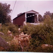
Herrville covered bridge across the Pequea Creek south of Lime Valley.
Provenance
Lancaster County covered bridge photos taken by M. E. Schroll and Kathryn L. Sauder taken between 1956 and 1958.
Date Range
August 1956
Storage Location
LancasterHistory, Lancaster, PA
Subcategory
Documentary Artifact
Search Terms
Bridges
Covered bridges
Herrville, Pequea Twp.
Lime Valley, West Lampeter Twp.
Pequea Creek
Object Name
Print, Photographic
Print Size
3.5 x 3.5 inches
Condition
Good
Object ID
1-09-03-63
Images
Less detail
More Like This
Permalink
Toggle Full Record
Print, Photographic
https://collections.lancasterhistory.org/en/permalink/4ae27840-0787-4b12-80cc-309352173194
Collection
General Collection
Object ID
1-09-03-64
Date Range
August 1958
More detail
1 image
Object Name
Print, Photographic
Collection
General Collection
Description
Herrville covered bridge on the Pequea Creek south of Lime Valley.
Provenance
Lancaster County covered bridge photos taken by M. E. Schroll and Kathryn L. Sauder taken between 1956 and 1958.
Date Range
August 1958
Storage Location
LancasterHistory, Lancaster, PA
Subcategory
Documentary Artifact
Search Terms
Bridges
Covered bridges
Herrville, Pequea Twp.
Lime Valley, West Lampeter Twp.
Pequea Creek
Object Name
Print, Photographic
Print Size
3.5 x 3.5 inches
Condition
Good
Object ID
1-09-03-64
Images
Less detail
More Like This
Permalink
Toggle Full Record
Print, Photographic
https://collections.lancasterhistory.org/en/permalink/69f030a4-faf6-466e-a4ad-467078315846
Collection
General Collection
Object ID
1-09-04-02
Date Range
July 1956
More detail
1 image
Object Name
Print, Photographic
Collection
General Collection
Description
Zook's Mill covered bridge across the Cocalico Creek south of Akron between West Earl and Warwick townships.
Provenance
Lancaster County covered bridge photos taken by M. E. Schroll and Kathryn L. Sauder taken between 1956 and 1958.
Date Range
July 1956
Storage Location
LancasterHistory, Lancaster, PA
Subcategory
Documentary Artifact
Search Terms
Zook's Mill
Covered bridges
Cocalico Creek
Akron, Pennsylvania
West Earl Twp.
Warwick Twp.
Creeks
Rose Hill Bridge
Object Name
Print, Photographic
Print Size
3.5 x 4.5 inches
Condition
Good
Object ID
1-09-04-02
Images
Less detail
More Like This
Permalink
Toggle Full Record
Transparency, Slide
https://collections.lancasterhistory.org/en/permalink/d5efd55b-3900-4168-99e9-335870102247
Collection
General Collection
Object ID
5-04-01-40
Date Range
1953
More detail
1 image
Object Name
Transparency, Slide
Collection
General Collection
Description
Donegal Springs at Donegal Presbyterian Church
Date Range
1953
Storage Location
LancasterHistory, Lancaster, PA
Search Terms
Donegal Presbyterian Church
Donegal Springs
Place
East Donegal Twp.
Object Name
Transparency, Slide
Film Size
35 mm
Object ID
5-04-01-40
Images
Less detail
More Like This
Permalink
Toggle Full Record
Print, Photographic
https://collections.lancasterhistory.org/en/permalink/cb827489-9f2b-4240-9168-690980811317
Collection
General Collection
Title
Bitzer's Mill Covered Bridge
Object ID
1-21-03-33
Date Range
24 October 1958
More detail
1 image
Object Name
Print, Photographic
Collection
General Collection
Title
Bitzer's Mill Covered Bridge
Description
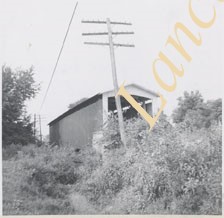
Covered bridge near Fairmount. Possibly Bitzer's Mill Covered Bridge.
Date Range
24 October 1958
Creator
Bond, George Ross
Storage Location
LancasterHistory, Lancaster, PA
Storage Room
Archives West
People
Bond, G. Ross
Subject
Photographs
Classification
1-21-03-33
Search Terms
Covered bridges
Bitzer's Mill Covered Bridge
Fairmount, West Earl Twp.
Conestoga River
Place
West Earl Twp.
Object Name
Print, Photographic
Original or Copy
Original
Print Size
3.25 x 4.75 inches
Dimention Details
Photograph is glued to black paper
Object ID
1-21-03-33
Credit
Courtesy of LancasterHistory, Lancaster, Pennsylvania
Images
Less detail
More Like This
Permalink
Toggle Full Record
Print, Photographic
https://collections.lancasterhistory.org/en/permalink/1ce9d6bd-f66f-44e5-bcb2-888595451860
Collection
General Collection
Title
Rupp's Mill
Object ID
1-21-03-53
Date Range
31 October 1958
More detail
1 image
Object Name
Print, Photographic
Collection
General Collection
Title
Rupp's Mill
Description
Rupp's Mill. Possibly also known as Farmersville Mill.
Date Range
31 October 1958
Storage Location
LancasterHistory, Lancaster, PA
Storage Room
Archives West
People
Bond, G. Ross
Subject
Photographs
Classification
1-21-03-53
Search Terms
Farmersville Mill
Mills
Rupp's Mill
West Earl Twp.
Place
West Earl Twp.
Object Name
Print, Photographic
Original or Copy
Original
Print Size
3.25 x 4.25 inches
Dimention Details
Photograph is glued to black paper
Object ID
1-21-03-53
Credit
Courtesy of LancasterHistory, Lancaster, Pennsylvania
Images
Less detail
More Like This
Permalink
Toggle Full Record
Print, Photographic
https://collections.lancasterhistory.org/en/permalink/296c6673-3a37-4258-bea2-449609487490
Collection
General Collection
Title
Photograph- Side view of King's Bridge on the West Branch of the Octoraro northwest of White Rock, between Colerain and Little Britain townships.
Object ID
1-09-03-51
Date Range
September 1, 1958
More detail
1 image
Object Name
Print, Photographic
Collection
General Collection
Title
Photograph- Side view of King's Bridge on the West Branch of the Octoraro northwest of White Rock, between Colerain and Little Britain townships.
Description
Side view of King's Bridge on the West Branch of the Octoraro northwest of White Rock, between Colerain and Little Britain townships.
Provenance
Lancaster County covered bridge photos taken by M. E. Schroll and Kathryn L. Sauder taken between 1956 and 1958.
Date Range
September 1, 1958
Storage Location
LancasterHistory, Lancaster, PA
Subcategory
Documentary Artifact
Search Terms
Bridges
King's Bridge
Covered bridges
Octoraro Creek, West Branch
White Rock, Little Britain Twp.
Creeks
Object Name
Print, Photographic
Print Size
3.5 x 3.5 inches
Condition
Good
Object ID
1-09-03-51
Images
Less detail
More Like This
Permalink
10 records – page 1 of 1.
Prev
Next