It appears no script is enabled within your browser. Please enable JavaScript to use this site.
Skip header and navigation
Toggle navigation
Collections
Search
Help
Privacy
Your Selections:
0
Items
Staff Login
Revise Search
Revise Search
Revise search
Search
Data Source
Photographs
13
×
Data Source
All
A
B
C
D
E
F
G
H
I
J
K
L
M
N
O
P
Q
R
S
T
U
V
W
X
Y
Z
Sort
By Count
Alphabetical
Filtered by
Filter
Loading...
Collection
General Collection
13
×
Collection
All
A
B
C
D
E
F
G
H
I
J
K
L
M
N
O
P
Q
R
S
T
U
V
W
X
Y
Z
Sort
By Count
Alphabetical
Filtered by
Filter
Loading...
Subject
Documentary Artifact
136
Neffsville, Manheim Twp.
28
Neffsville Junior High School
25
Bridges
24
West Orange Street
18
West King Street
16
Road construction
14
Robert Fulton Highway
14
Route 222
14
West Chestnut Street
14
Covered bridges
Conestoga River
12
More
×
Subject
All
A
B
C
D
E
F
G
H
I
J
K
L
M
N
O
P
Q
R
S
T
U
V
W
X
Y
Z
Sort
By Count
Alphabetical
Filtered by
Filter
Loading...
Place
Conestoga Twp.
2
Earl Twp.
2
East Cocalico Twp.
2
East Earl Twp.
2
Colerain Twp.
1
Manor Twp.
1
Pequea Twp.
1
West Lampeter Twp.
1
×
Place
All
A
B
C
D
E
F
G
H
I
J
K
L
M
N
O
P
Q
R
S
T
U
V
W
X
Y
Z
Sort
By Count
Alphabetical
Filtered by
Filter
Loading...
Decade
1900s
4
1920s
1930s
7
1940s
1
1950s
105
1960s
5
1970s
3
1990s
4
2000s
23
×
Decade
All
A
B
C
D
E
F
G
H
I
J
K
L
M
N
O
P
Q
R
S
T
U
V
W
X
Y
Z
Sort
By Count
Alphabetical
Filtered by
Filter
Loading...
Material
Print, Photographic
13
×
Material
All
A
B
C
D
E
F
G
H
I
J
K
L
M
N
O
P
Q
R
S
T
U
V
W
X
Y
Z
Sort
By Count
Alphabetical
Filtered by
Filter
Loading...
Online Media
Image
PDF
2
×
Online Media
All
A
B
C
D
E
F
G
H
I
J
K
L
M
N
O
P
Q
R
S
T
U
V
W
X
Y
Z
Sort
By Count
Alphabetical
Filtered by
Filter
Loading...
Advanced Search
Help
more like: 0147D99B-6C7E-4C10-9C2A-777329596680
Image
Covered bridges
1920s
Sorted by
Relevance
Sort by Title
Expand All
Collapse All
List View
Gallery View
Print
10 records – page 1 of 1.
Prev
Next
Toggle Full Record
Print, Photographic
https://collections.lancasterhistory.org/en/permalink/39b83607-6b74-4005-a8a0-816505428770
Collection
General Collection
Object ID
1-20-06-05
More detail
1 image
Object Name
Print, Photographic
Collection
General Collection
Description
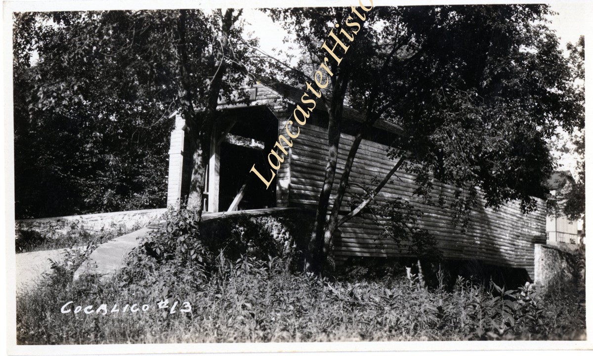
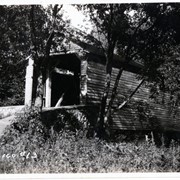
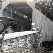
Identified as bridge #13 over Pequea Creek. Possibly Lime Valley Covered Bridge.
Provenance
Photographs taken by Lancaster County during bridge repair work. Gift of Gordon Reed.
Year Range From
1920
Year Range To
1929
Storage Location
LancasterHistory, Lancaster, PA
Search Terms
Covered bridges
Pequea Creek
Lime Valley, West Lampeter Twp.
Lime Valley Covered Bridge
Place
West Lampeter Twp.
Object Name
Print, Photographic
Print Size
3.25 x 5.5 inches
Object ID
1-20-06-05
Images
Less detail
More Like This
Permalink
Toggle Full Record
Print, Photographic
https://collections.lancasterhistory.org/en/permalink/b044a01c-1a7b-4863-9060-374678892714
Collection
General Collection
Object ID
1-20-05-11
More detail
1 image
Object Name
Print, Photographic
Collection
General Collection
Description
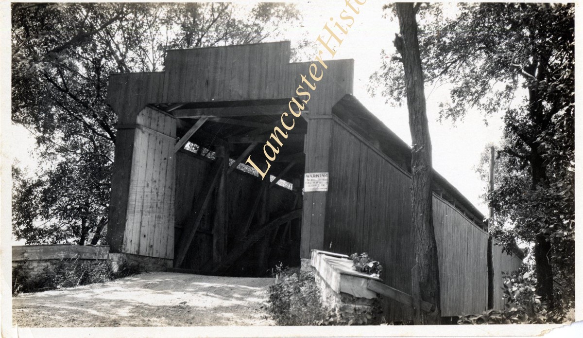
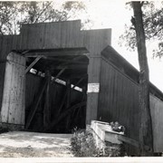
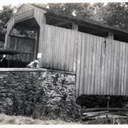
Bridge #13 over Cocalico Creek - Covered bridge on Log Cabin Road known as Zook's Mill Covered Bridge and Rose Hill Covered Bridge
Provenance
Photographs taken by Lancaster County during bridge repair work. Gift of Gordon Reed.
Year Range From
1920
Year Range To
1929
Storage Location
LancasterHistory, Lancaster, PA
Search Terms
Bridges
Cocalico Creek
Covered bridges
Creeks
Log Cabin Road
Rose Hill Bridge
West Earl Twp.
Zook's Mill Bridge
Object Name
Print, Photographic
Print Size
3.25 x 5.5 inches
Object ID
1-20-05-11
Images
Less detail
More Like This
Permalink
Toggle Full Record
Print, Photographic
https://collections.lancasterhistory.org/en/permalink/56e26152-bffb-4a25-b6f5-313649542259
Collection
General Collection
Object ID
1-20-04-55
More detail
1 image
Object Name
Print, Photographic
Collection
General Collection
Description
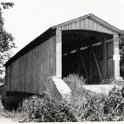
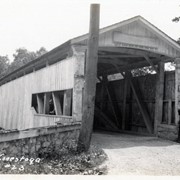
Covered bridge. Bridge number 5 over the Conestoga River, possibly at Weaverland.
Provenance
Photographs taken by Lancaster County during bridge repair work. Gift of Gordon Reed.
Year Range From
1920
Year Range To
1929
Storage Location
LancasterHistory, Lancaster, PA
Search Terms
Covered bridges
Weaverland, East Earl Twp.
Place
East Earl Twp.
Object Name
Print, Photographic
Print Size
3.25 x 5.5 inches
Object ID
1-20-04-55
Images
Less detail
More Like This
Permalink
Toggle Full Record
Print, Photographic
https://collections.lancasterhistory.org/en/permalink/e4025670-10d1-4001-9397-982771434042
Collection
General Collection
Object ID
1-20-04-56
More detail
1 image
Object Name
Print, Photographic
Collection
General Collection
Description
Covered bridge. Bridge number 5 over the Conestoga River, possibly at Weaverland.
Provenance
Photographs taken by Lancaster County during bridge repair work. Gift of Gordon Reed.
Year Range From
1920
Year Range To
1929
Storage Location
LancasterHistory, Lancaster, PA
Search Terms
Covered bridges
Weaverland, East Earl Twp.
Place
East Earl Twp.
Object Name
Print, Photographic
Print Size
3.25 x 5.5 inches
Object ID
1-20-04-56
Images
Less detail
More Like This
Permalink
Toggle Full Record
Print, Photographic
https://collections.lancasterhistory.org/en/permalink/b1553a20-35f9-4bae-9bd2-504284932800
Collection
General Collection
Object ID
1-20-04-57
More detail
1 image
Object Name
Print, Photographic
Collection
General Collection
Description
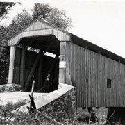
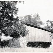
Covered bridge. Bridge number 6 over the Conestoga River, possibly on White Oak Road near Martindale.
Provenance
Photographs taken by Lancaster County during bridge repair work. Gift of Gordon Reed.
Year Range From
1920
Year Range To
1929
Storage Location
LancasterHistory, Lancaster, PA
Search Terms
Covered bridges
Conestoga River
Martindale, Earl Twp.
Place
Earl Twp.
Object Name
Print, Photographic
Print Size
3.25 x 5.5 inches
Object ID
1-20-04-57
Images
Less detail
More Like This
Permalink
Toggle Full Record
Print, Photographic
https://collections.lancasterhistory.org/en/permalink/b1104576-702e-4b76-af5d-316152117390
Collection
General Collection
Object ID
1-20-04-58
More detail
1 image
Object Name
Print, Photographic
Collection
General Collection
Description
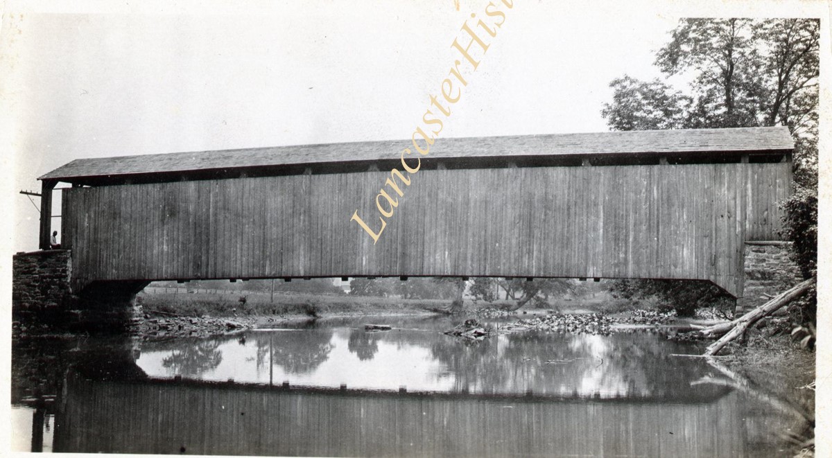
Covered bridge. Bridge number 7 over the Conestoga River, possibly on Gristmill Road near Martindale.
Provenance
Photographs taken by Lancaster County during bridge repair work. Gift of Gordon Reed.
Year Range From
1920
Year Range To
1929
Storage Location
LancasterHistory, Lancaster, PA
Search Terms
Covered bridges
Conestoga River
Martindale, Earl Twp.
Place
Earl Twp.
Object Name
Print, Photographic
Print Size
3.25 x 5.5 inches
Object ID
1-20-04-58
Images
Less detail
More Like This
Permalink
Toggle Full Record
Print, Photographic
https://collections.lancasterhistory.org/en/permalink/956bac6f-6d4f-4ad2-8344-407433157220
Collection
General Collection
Object ID
1-20-04-75
More detail
1 image
Object Name
Print, Photographic
Collection
General Collection
Description
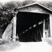
Bridge #23 over the Conestoga River near Slackwater
Provenance
Photographs taken by Lancaster County during bridge repair work. Gift of Gordon Reed.
Year Range From
1920
Year Range To
1929
Storage Location
LancasterHistory, Lancaster, PA
Search Terms
Covered bridges
Conestoga River
Slackwater, Conestoga Twp.
Place
Manor Twp.
Object Name
Print, Photographic
Print Size
3.25 x 5.5 inches
Object ID
1-20-04-75
Images
Less detail
More Like This
Permalink
Toggle Full Record
Print, Photographic
https://collections.lancasterhistory.org/en/permalink/ac637f37-253f-4bb7-869f-340245164915
Collection
General Collection
Object ID
1-20-04-83
More detail
1 image
Object Name
Print, Photographic
Collection
General Collection
Description
Bridge #3 over Muddy Creek, possibly Fry's Mill Covered Bridge
Provenance
Photographs taken by Lancaster County during bridge repair work. Gift of Gordon Reed.
Year Range From
1920
Year Range To
1929
Storage Location
LancasterHistory, Lancaster, PA
Search Terms
Covered bridges
Muddy Creek
Frysville, East Cocalico Twp.
Fry's Mill Covered Bridge
Place
East Cocalico Twp.
Object Name
Print, Photographic
Print Size
3.25 x 5.5 inches
Object ID
1-20-04-83
Images
Less detail
More Like This
Permalink
Toggle Full Record
Print, Photographic
https://collections.lancasterhistory.org/en/permalink/e9916c1f-be06-4d7c-ab67-816411519390
Collection
General Collection
Object ID
1-20-04-99
More detail
1 image
Object Name
Print, Photographic
Collection
General Collection
Description
Bridge #2 over Cocalico Creek - possibly Bucher's Mill Covered Bridge
Provenance
Photographs taken by Lancaster County during bridge repair work. Gift of Gordon Reed.
Year Range From
1920
Year Range To
1929
Storage Location
LancasterHistory, Lancaster, PA
Search Terms
Bridges
Bucher's Mill
Bucher's Mill Covered Bridge
Cocalico Creek
Covered bridges
Creeks
East Cocalico Twp.
Mills
Place
East Cocalico Twp.
Object Name
Print, Photographic
Print Size
3.25 x 5.5 inches
Object ID
1-20-04-99
Images
Less detail
More Like This
Permalink
Toggle Full Record
Print, Photographic
https://collections.lancasterhistory.org/en/permalink/5f8bb483-ed54-439b-9449-384761596880
Collection
General Collection
Object ID
1-20-05-19
More detail
1 image
Object Name
Print, Photographic
Collection
General Collection
Description
Bridge #3 over the west branch of the Octoraro Creek - possibly near Puseyville
Provenance
Photographs taken by Lancaster County during bridge repair work. Gift of Gordon Reed.
Year Range From
1920
Year Range To
1929
Storage Location
LancasterHistory, Lancaster, PA
Search Terms
Bridges
Covered bridges
Octoraro Creek
Puseyville, East Drumore Twp.
Place
Colerain Twp.
Object Name
Print, Photographic
Print Size
3.25 x 5.5 inches
Object ID
1-20-05-19
Images
Less detail
More Like This
Permalink
10 records – page 1 of 1.
Prev
Next