It appears no script is enabled within your browser. Please enable JavaScript to use this site.
Skip header and navigation
Toggle navigation
Collections
Search
Help
Privacy
Your Selections:
0
Items
Staff Login
Revise Search
Revise Search
Revise search
Search
Data Source
Archives
48501
Photographs
Artifacts
17
×
Data Source
All
A
B
C
D
E
F
G
H
I
J
K
L
M
N
O
P
Q
R
S
T
U
V
W
X
Y
Z
Sort
By Count
Alphabetical
Filtered by
Filter
Loading...
Collection
General Collection
Lancaster Recreation Commission Photograph Collection
9102
Henry Kauffman Photograph Collection
7170
Darmstaetter Collection
6841
Heritage Center Collection
5264
Actors Company Photograph Collection
3374
Johnny Hauck Photograph Collection
2583
Discover Lancaster Photograph Collection
2182
Sarah Ann Stauffer Photograph Collection
2038
Postcard Collection
2006
John D. Denney, Jr. Photograph Collection
1657
Bruce Ryder Photograph Collection
1308
More
×
Collection
All
A
B
C
D
E
F
G
H
I
J
K
L
M
N
O
P
Q
R
S
T
U
V
W
X
Y
Z
Sort
By Count
Alphabetical
Filtered by
Filter
Loading...
Subject
Documentary Artifact
16752
Railroads
605
Agriculture
467
Portraits
432
Education
431
Military
426
Stockyards
412
Women
398
North Queen Street
394
Construction
388
Parades
371
Covered bridges
369
More
×
Subject
All
A
B
C
D
E
F
G
H
I
J
K
L
M
N
O
P
Q
R
S
T
U
V
W
X
Y
Z
Sort
By Count
Alphabetical
Filtered by
Filter
Loading...
Name
Heiges, George L.
423
Merchant, Robert
395
Rothwell, Gerald
379
Hostetter, Harry B.
335
Thompson, Robert Hugh Sr.
323
Darmstaetter's
239
Bond, George Ross
223
Saylor, B. Frank
202
Einolf, Albert L.
188
Schwebel, John F.
171
Bowman, Robert W.
136
Loose, John Ward Willson
112
More
×
Name
All
A
B
C
D
E
F
G
H
I
J
K
L
M
N
O
P
Q
R
S
T
U
V
W
X
Y
Z
Sort
By Count
Alphabetical
Filtered by
Filter
Loading...
Place
Lancaster
5397
Manheim Twp.
303
Manheim
232
Martic Twp.
206
Lancaster Twp.
147
Conestoga Twp.
145
Manor Twp.
140
Columbia
129
Ephrata
126
East Donegal Twp.
125
West Lampeter Twp.
116
Lititz
88
More
×
Place
All
A
B
C
D
E
F
G
H
I
J
K
L
M
N
O
P
Q
R
S
T
U
V
W
X
Y
Z
Sort
By Count
Alphabetical
Filtered by
Filter
Loading...
Decade
1070s
1
1740s
1
1800s
3
1840s
5
1850s
39
1860s
166
1870s
83
1880s
131
1890s
275
1900s
456
1910s
735
1920s
777
1930s
748
1940s
767
1950s
841
1960s
916
1970s
1073
1980s
557
1990s
868
2000s
922
2010s
13
×
Decade
All
A
B
C
D
E
F
G
H
I
J
K
L
M
N
O
P
Q
R
S
T
U
V
W
X
Y
Z
Sort
By Count
Alphabetical
Filtered by
Filter
Loading...
Material
Print, Photographic
15202
Negative
1105
Transparency, Slide
540
Negative, Glass Plate
320
Tintype
76
Daguerreotype
10
Transparency, Lantern Slide
9
Slide
8
Ambrotype
4
Postcard
3
Stereograph
2
Stereoview
1
More
×
Material
All
A
B
C
D
E
F
G
H
I
J
K
L
M
N
O
P
Q
R
S
T
U
V
W
X
Y
Z
Sort
By Count
Alphabetical
Filtered by
Filter
Loading...
Online Media
Image
17091
×
Online Media
All
A
B
C
D
E
F
G
H
I
J
K
L
M
N
O
P
Q
R
S
T
U
V
W
X
Y
Z
Sort
By Count
Alphabetical
Filtered by
Filter
Loading...
Advanced Search
Help
more like: 15E2670C-EE30-44BD-8A4D-141829257745
Administrators Accounts
Collateral Appraisements
Estate Inventories
Estate Vouchers
General Collection
Marriage Applications and Consent Forms
Marriage Licenses
Renunciations
Vendue Lists
Photographs
Sorted by
Relevance
Sort by Title
Expand All
Collapse All
List View
Gallery View
Print
20 records – page 1 of 1.
Prev
Next
Toggle Full Record
Transparency, Slide
https://collections.lancasterhistory.org/en/permalink/0efa3f9b-65b4-4f17-814d-106101825051
Collection
General Collection
Object ID
1-16-02-58
More detail
1 image
Object Name
Transparency, Slide
Collection
General Collection
Description
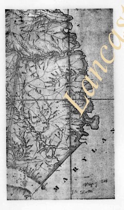
Southern portion of Joshua Scott's 1824 map of Lancaster County.
Storage Location
LancasterHistory, Lancaster, PA
People
Scott, Joshua
Subcategory
Documentary Artifact
Search Terms
Maps
Object Name
Transparency, Slide
Film Size
1 x 1.5 inches
Object ID
1-16-02-58
Images
Less detail
More Like This
Permalink
Toggle Full Record
Transparency, Slide
https://collections.lancasterhistory.org/en/permalink/3a58b7e0-496d-4b86-9a39-735122288599
Collection
General Collection
Object ID
1-16-02-65
More detail
1 image
Object Name
Transparency, Slide
Collection
General Collection
Description
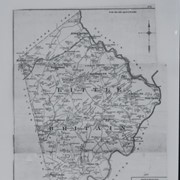
Map of Little Britain Township
Storage Location
LancasterHistory, Lancaster, PA
Subcategory
Documentary Artifact
Search Terms
Maps
Place
Little Britain Twp.
Object Name
Transparency, Slide
Film Size
1 x 1.5 inches
Object ID
1-16-02-65
Images
Less detail
More Like This
Permalink
Toggle Full Record
Transparency, Slide
https://collections.lancasterhistory.org/en/permalink/ea6b6514-e6cb-4415-828b-311047353540
Collection
General Collection
Object ID
1-16-02-67
More detail
1 image
Object Name
Transparency, Slide
Collection
General Collection
Description
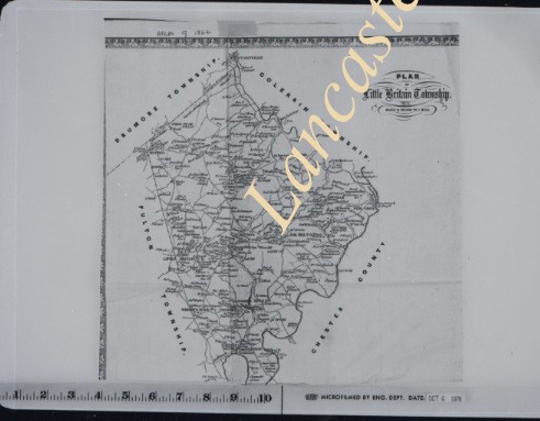
Map of Little Britain Township
Storage Location
LancasterHistory, Lancaster, PA
Subcategory
Documentary Artifact
Search Terms
Maps
Place
Little Britain Twp.
Object Name
Transparency, Slide
Film Size
1 x 1.5 inches
Object ID
1-16-02-67
Images
Less detail
More Like This
Permalink
Toggle Full Record
Transparency, Slide
https://collections.lancasterhistory.org/en/permalink/87e35ec0-ab87-4297-bd76-161212170594
Collection
General Collection
Object ID
1-16-02-68
More detail
1 image
Object Name
Transparency, Slide
Collection
General Collection
Description
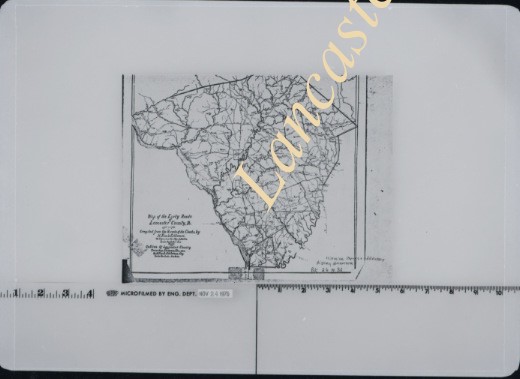
Map of Lancaster County showing creeks and streams.
Storage Location
LancasterHistory, Lancaster, PA
Subcategory
Documentary Artifact
Search Terms
Maps
Object Name
Transparency, Slide
Film Size
1 x 1.5 inches
Object ID
1-16-02-68
Images
Less detail
More Like This
Permalink
Toggle Full Record
Transparency, Slide
https://collections.lancasterhistory.org/en/permalink/01621032-cd27-4e53-903e-238063839851
Collection
General Collection
Object ID
1-16-02-75
More detail
1 image
Object Name
Transparency, Slide
Collection
General Collection
Description
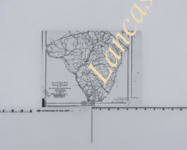
Map of Lancaster County showing creeks and streams
Storage Location
LancasterHistory, Lancaster, PA
Subcategory
Documentary Artifact
Search Terms
Maps
Object Name
Transparency, Slide
Film Size
1 x 1.5 inches
Object ID
1-16-02-75
Images
Less detail
More Like This
Permalink
Toggle Full Record
Transparency, Slide
https://collections.lancasterhistory.org/en/permalink/b33ed588-a1bd-470a-a07e-086348378136
Collection
General Collection
Object ID
1-16-02-76
More detail
1 image
Object Name
Transparency, Slide
Collection
General Collection
Description
Plot map
Storage Location
LancasterHistory, Lancaster, PA
Subcategory
Documentary Artifact
Search Terms
Maps
Object Name
Transparency, Slide
Film Size
1 x 1.5 inches
Object ID
1-16-02-76
Images
Less detail
More Like This
Permalink
Toggle Full Record
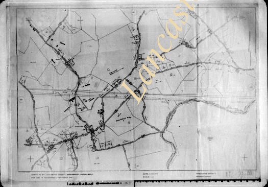
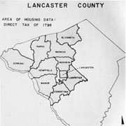
Print, Photographic
https://collections.lancasterhistory.org/en/permalink/c6013246-45c4-4bcf-b161-856804965559
Collection
General Collection
Title
Photograph- Map of Lancaster County showing area of housing data, direct tax of 1798.
Object ID
1-03-02-76
More detail
1 image
Object Name
Print, Photographic
Collection
General Collection
Title
Photograph- Map of Lancaster County showing area of housing data, direct tax of 1798.
Description
Map of Lancaster County showing area of housing data, direct tax of 1798.
Storage Location
LancasterHistory, Lancaster, PA
Subcategory
Documentary Artifact
Search Terms
Maps
Government
Taxes
Object Name
Print, Photographic
Print Size
5 x 7 inches
Related Publications
LCHS Journal Vol. 85, No. 4, article by Art Lord
Object ID
1-03-02-76
Images
Less detail
More Like This
Permalink
Toggle Full Record
Print, Photographic
https://collections.lancasterhistory.org/en/permalink/86540c45-d2db-4c88-8a2b-429040204926
Collection
General Collection
Title
Photograph- Map of Lancaster County showing area of housing data, direct tax of 1798.
Object ID
1-03-02-77
Date Range
1852
More detail
1 image
Object Name
Print, Photographic
Collection
General Collection
Title
Photograph- Map of Lancaster County showing area of housing data, direct tax of 1798.
Description
Map of Safe Harbor by R. S. Bridges.
Date Range
1852
Storage Location
LancasterHistory, Lancaster, PA
Subcategory
Documentary Artifact
Search Terms
Maps
Safe Harbor, Conestoga Twp.
Object Name
Print, Photographic
Print Size
5 x 7 inches
Related Publications
LCHS Journal, vol. 85, No. 3 p. 91
Object ID
1-03-02-77
Images
Less detail
More Like This
Permalink
Toggle Full Record
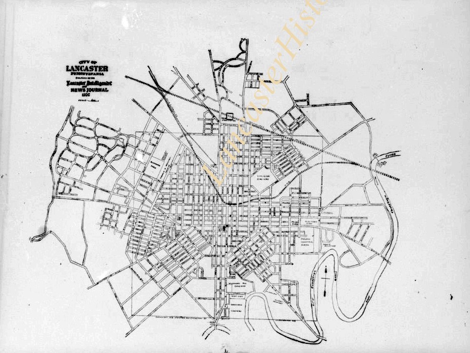
Negative
https://collections.lancasterhistory.org/en/permalink/b18ed97b-4b04-4d95-bc08-223563372348
Collection
General Collection
Title
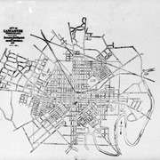
Photograph- Map of Lancaster city.
Object ID
1-18-01-17
Date Range
January 3, 1927
More detail
1 image
Object Name
Negative
Collection
General Collection
Title
Photograph- Map of Lancaster city.
Description
Map of Lancaster city. Customer: Intelligencer
Date Range
January 3, 1927
Storage Location
LancasterHistory, Lancaster, PA
Studio
Darmstaetter's
Subcategory
Documentary Artifact
Search Terms
Maps
Lancaster
Object Name
Negative
Object ID
1-18-01-17
Negative Number
3 1/2" x 2 1/2"
Other Number
646-199
Images
Less detail
More Like This
Permalink
Toggle Full Record
Print, Photographic
https://collections.lancasterhistory.org/en/permalink/ac1814b9-031e-4df5-91f6-900519228455
Collection
General Collection
Object ID
2-18-02-54
More detail
1 image
Object Name
Print, Photographic
Collection
General Collection
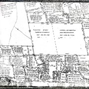
Description
Northwest Gateway/Armstrong Project. Map at area previously occupied by Armstrong.
Storage Location
LancasterHistory, Lancaster, PA
Subcategory
Documentary Artifact
Search Terms
Demolition
Armstrong World Industries
Armstrong Building
Armstrong
Northwest Gateway/Armstrong Project
Maps
Object Name
Print, Photographic
Condition
Good
Object ID
2-18-02-54
Images
Less detail
More Like This
Permalink
Toggle Full Record
Print, Photographic
https://collections.lancasterhistory.org/en/permalink/d41efa4b-c35b-4137-be26-308424153734
Collection
General Collection
Object ID
2-18-02-55
More detail
1 image
Object Name
Print, Photographic
Collection
General Collection
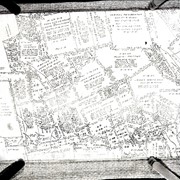
Description
Long term vision for area once occupied by Armstong "Northwest Gateway/Armstrong Project"
Storage Location
LancasterHistory, Lancaster, PA
Subcategory
Documentary Artifact
Search Terms
Demolition
Armstrong World Industries
Armstrong Building
Armstrong
Maps
Plans
Northwest Gateway/Armstrong Project
Object Name
Print, Photographic
Condition
Good
Object ID
2-18-02-55
Images
Less detail
More Like This
Permalink
Toggle Full Record
Negative
https://collections.lancasterhistory.org/en/permalink/abc42797-21ac-4b1e-ab13-368911824673
Collection
General Collection
Object ID
2-18-10-17
More detail
1 image
Object Name
Negative
Collection
General Collection
Description
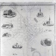
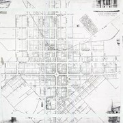
Moody & Bridgen's 1850 Map of City of Lancaster
Storage Location
LancasterHistory, Lancaster, PA
Subcategory
Documentary Artifact
Search Terms
Maps
Place
Lancaster
Object Name
Negative
Print Size
7 x 11 inches
Condition
Good
Object ID
2-18-10-17
Images
Less detail
More Like This
Permalink
Toggle Full Record
Print, Photographic
https://collections.lancasterhistory.org/en/permalink/cc8fda18-232a-4127-9d36-146411351330
Collection
General Collection
Title
Photograph- Map of Manor Township
Object ID
1-08-08-15
More detail
1 image
Object Name
Print, Photographic
Collection
General Collection
Title
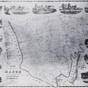
Photograph- Map of Manor Township
Description
Map of Manor Township
Storage Location
LancasterHistory, Lancaster, PA
Subcategory
Documentary Artifact
Search Terms
Maps
Place
Manor Twp.
Object Name
Print, Photographic
Print Size
5 x 7 inches
Condition
Good
Object ID
1-08-08-15
Images
Less detail
More Like This
Permalink
Toggle Full Record
Negative
https://collections.lancasterhistory.org/en/permalink/d2dce78a-f26d-4d7f-9fbd-207736554690
Collection
General Collection
Title
Photograph- 1912 Sanborn Fire Insurance Map showing Lancaster County Home and Hospital.
Object ID
1-09-02-97
More detail
1 image
Object Name
Negative
Collection
General Collection
Title
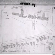
Photograph- 1912 Sanborn Fire Insurance Map showing Lancaster County Home and Hospital.
Description
1912 Sanborn Fire Insurance Map showing Lancaster County Home and Hospital.
Storage Location
LancasterHistory, Lancaster, PA
Subcategory
Documentary Artifact
Search Terms
Lancaster County Almshouse
Hospitals
Maps
Place
Lancaster
Object Name
Negative
Condition
Good
Object ID
1-09-02-97
Negative Number
yes
Images
Less detail
More Like This
Permalink
Toggle Full Record
Negative
https://collections.lancasterhistory.org/en/permalink/d30c67b2-d0f2-4987-ac89-581106662382
Collection
General Collection
Object ID
2-14-06-01
More detail
1 image
Object Name
Negative
Collection
General Collection
Description
Detail of warrant map
Provenance
From the Slaymaker Collection
Storage Location
LancasterHistory, Lancaster, PA
Subcategory
Documentary Artifact
Search Terms
Warrant maps
Negatives
Object Name
Negative
Print Size
8 x 10 inches
Object ID
2-14-06-01
Images
Less detail
More Like This
Permalink
Toggle Full Record
Negative
https://collections.lancasterhistory.org/en/permalink/2c8261ac-6cb3-4230-b83f-053328387998
Collection
General Collection
Object ID
2-14-06-02
More detail
1 image
Object Name
Negative
Collection
General Collection
Description
Detail of warrant map
Provenance
From the Slaymaker Collection
Storage Location
LancasterHistory, Lancaster, PA
Subcategory
Documentary Artifact
Search Terms
Warrant maps
Negatives
Object Name
Negative
Print Size
8 x 10 inches
Object ID
2-14-06-02
Images
Less detail
More Like This
Permalink
Toggle Full Record
Negative, Glass Plate
https://collections.lancasterhistory.org/en/permalink/81b29635-18e9-4e66-a866-236765003880
Collection
General Collection
Object ID
1-12-01-66
More detail
1 image
Object Name
Negative, Glass Plate
Collection
General Collection
Description
Map of the city of Lancaster and adjacent townships.
Provenance
Found in Museum Storage
Storage Location
LancasterHistory, Lancaster, PA
Subcategory
Documentary Artifact
Search Terms
Maps
Place
Lancaster
Object Name
Negative, Glass Plate
Print Size
5 x 7 inches
Object ID
1-12-01-66
Images
Less detail
More Like This
Permalink
Toggle Full Record
Negative, Glass Plate
https://collections.lancasterhistory.org/en/permalink/d1ba94f5-32b5-45b4-9b36-061847405680
Collection
General Collection
Object ID
1-12-01-73
More detail
1 image
Object Name
Negative, Glass Plate
Collection
General Collection
Description
Map of the city of Lancaster showing major highways and routes.
Provenance
Found in Museum Storage
Storage Location
LancasterHistory, Lancaster, PA
Subcategory
Documentary Artifact
Search Terms
Maps
Place
Lancaster
Object Name
Negative, Glass Plate
Print Size
4.25 x 6.25 inches
Object ID
1-12-01-73
Images
Less detail
More Like This
Permalink
Toggle Full Record
Print, Photographic
https://collections.lancasterhistory.org/en/permalink/b92fdbde-5b79-4b75-9df5-364271395199
Collection
General Collection
Object ID
2-16-03-13
More detail
1 image
Object Name
Print, Photographic
Collection
General Collection
Description
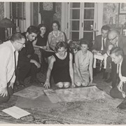
Clyde Groff, at left, with group of people looking at an old map of Lancaster County.
Storage Location
LancasterHistory, Lancaster, PA
People
Groff, Clyde
Subcategory
Documentary Artifact
Search Terms
Maps
Object Name
Print, Photographic
Print Size
8 x 10 inches
Condition
Excellent
Condition Notes
2008-12-02
Object ID
2-16-03-13
Images
Less detail
More Like This
Permalink
Toggle Full Record
Negative
https://collections.lancasterhistory.org/en/permalink/15d740de-dfb4-4ce6-b82d-404739412633
Collection
General Collection
Object ID
3-11-01-24
More detail
1 image
Object Name
Negative
Collection
General Collection
Description
1850 map of the city of Lancaster
Storage Location
LancasterHistory, Lancaster, PA
Subcategory
Documentary Artifact
Search Terms
Maps
Place
Lancaster
Object Name
Negative
Print Size
20 x 24 inches
Condition
Good
Object ID
3-11-01-24
Images
Less detail
More Like This
Permalink
20 records – page 1 of 1.
Prev
Next