Skip header and navigation

Revise Search

10 records – page 1 of 1.

Collection
Covered Bridge Album
Object ID
A-11-01-12
Date Range
1950
  1 image  
Object Name
Print, Photographic
Collection
Covered Bridge Album
Description
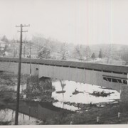
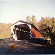
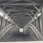
Slackwater, aslo known as Shober's Paper Mill, one mile south of Millersville between Conestoga and Manor Townships. State supervised on road LR 36008, oldest bridge still standing, built 1839, double span 269 feet long.
Date Range
1950
Creator
Gaintner, Jay Richard
Storage Location
LancasterHistory, Lancaster, PA
Subcategory
Documentary Artifact
Search Terms
Bridges
Covered bridges
Mills
Conestoga River
Slackwater, Conestoga Twp.
Object Name
Print, Photographic
Print Size
8 x 10 inches
Object ID
A-11-01-12
Images
Less detail
Collection
General Collection
Object ID
1-09-03-89
Date Range
August 1956
  1 image  
Object Name
Print, Photographic
Collection
General Collection
Description
Covered bridge, Possibly Second Lock bridge, on the Conestoga River north of New Danville between Pequea and Lancaster townships.
Provenance
Lancaster County covered bridge photos taken by M. E. Schroll and Kathryn L. Sauder taken between 1956 and 1958.
Date Range
August 1956
Storage Location
LancasterHistory, Lancaster, PA
Subcategory
Documentary Artifact
Search Terms
Covered bridges
Second Lock Bridge
Conestoga River
New Danville, Pequea Twp.
Pequea Twp.
Lancaster Twp.
Object Name
Print, Photographic
Print Size
3.5 x 3.5 inches
Condition
Good
Object ID
1-09-03-89
Images
Less detail
Collection
General Collection
Object ID
1-09-03-90
Date Range
August 7, 1958
  1 image  
Object Name
Print, Photographic
Collection
General Collection
Description
Possibly Second Lock bridge over the Conestoga north of New Danville between Pequea and Lancaster townships.
Provenance
Lancaster County covered bridge photos taken by M. E. Schroll and Kathryn L. Sauder taken between 1956 and 1958.
Date Range
August 7, 1958
Storage Location
LancasterHistory, Lancaster, PA
Subcategory
Documentary Artifact
Search Terms
Second Lock Bridge
Conestoga River
New Danville, Pequea Twp.
Pequea Twp.
Lancaster Twp.
Covered bridges
Object Name
Print, Photographic
Print Size
3.5 x 3.5 inches
Condition
Good
Object ID
1-09-03-90
Images
Less detail
Collection
General Collection
Object ID
1-09-03-70
Date Range
1956
  1 image  
Object Name
Print, Photographic
Collection
General Collection
Description
Covered bridge across the Pequea Creek at Colemanville between Martic and Conestoga townships.
Provenance
Lancaster County covered bridge photos taken by M. E. Schroll and Kathryn L. Sauder taken between 1956 and 1958.
Date Range
1956
Storage Location
LancasterHistory, Lancaster, PA
Subcategory
Documentary Artifact
Search Terms
Covered bridges
Pequea Creek
Colemanville, Conestoga Twp.
Martic Twp.
Object Name
Print, Photographic
Print Size
3.5 x 3.5 inches
Condition
Good
Object ID
1-09-03-70
Images
Less detail
Collection
General Collection
Object ID
1-09-03-83
Date Range
August 1958
  1 image  
Object Name
Print, Photographic
Collection
General Collection
Description
Hunsecker's Mill Bridge on the Conestoga River between Manheim and Upper Leacock townships. Destroyed by Hurricane Agnes, June 22, 1972 but rebuilt on the same site.
Provenance
Lancaster County covered bridge photos taken by M. E. Schroll and Kathryn L. Sauder taken between 1956 and 1958.
Date Range
August 1958
Storage Location
LancasterHistory, Lancaster, PA
Subcategory
Documentary Artifact
Search Terms
Hunsecker's Mill
Covered bridges
Conestoga River
Manheim Twp.
Upper Leacock Twp.
Object Name
Print, Photographic
Print Size
3.5 x 3.5 inches
Condition
Good
Object ID
1-09-03-83
Images
Less detail
Collection
General Collection
Object ID
1-09-03-87
Date Range
August 1956
  1 image  
Object Name
Print, Photographic
Collection
General Collection
Description
Wabank Mill Bridge, also called Third Lock Bridge, on the Conestoga River between Lancaster and Pequea townships.
Provenance
Lancaster County covered bridge photos taken by M. E. Schroll and Kathryn L. Sauder taken between 1956 and 1958.
Date Range
August 1956
Storage Location
LancasterHistory, Lancaster, PA
Subcategory
Documentary Artifact
Search Terms
Bridges
Conestoga River
Covered bridges
Creeks
Lancaster Twp.
Mills
Pequea Twp.
Third Lock Bridge
Wabank Mill
Wabank Mill Bridge
Object Name
Print, Photographic
Print Size
3.5 x 3.5 inches
Condition
Good
Object ID
1-09-03-87
Images
Less detail
Collection
General Collection
Object ID
1-09-03-88
Date Range
August 7, 1958
  1 image  
Object Name
Print, Photographic
Collection
General Collection
Description
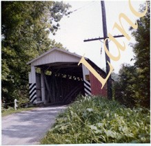
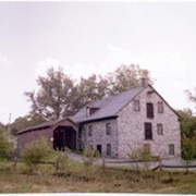
Wabank Mill bridge, also called Third Lock bridge, on the Conestoga River between Lancaster and Pequea townships. This bridge was replaced by a road relocation in 1958.
Provenance
Lancaster County covered bridge photos taken by M. E. Schroll and Kathryn L. Sauder taken between 1956 and 1958.
Date Range
August 7, 1958
Storage Location
LancasterHistory, Lancaster, PA
Subcategory
Documentary Artifact
Search Terms
Bridges
Conestoga River
Covered bridges
Creeks
Lancaster Twp.
Mills
Pequea Twp.
Third Lock Bridge
Wabank Mill
Wabank Mill Bridge
Object Name
Print, Photographic
Print Size
3.5 x 3.5 inches
Condition
Good
Object ID
1-09-03-88
Images
Less detail
Collection
General Collection
Object ID
1-09-03-92
Date Range
November 12, 1958
  1 image  
Object Name
Print, Photographic
Collection
General Collection
Description
Possibly Second Lock bridge interior - on the Big Conestoga. Double arch, longest in county. Between Lancaster and Pequea townships.
Provenance
Lancaster County covered bridge photos taken by M. E. Schroll and Kathryn L. Sauder taken between 1956 and 1958.
Date Range
November 12, 1958
Storage Location
LancasterHistory, Lancaster, PA
Subcategory
Documentary Artifact
Search Terms
Second Lock Bridge
Conestoga River
Lancaster Twp.
Pequea Twp.
Covered bridges
Object Name
Print, Photographic
Print Size
3.5 x 3.5 inches
Condition
Good
Object ID
1-09-03-92
Images
Less detail
Collection
General Collection
Object ID
1-09-04-10
Date Range
December 1956
  1 image  
Object Name
Print, Photographic
Collection
General Collection
Description
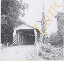
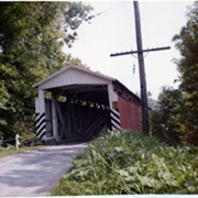
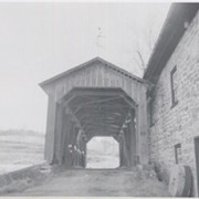
Covered bridge on the Little Conestoga Creek south of Maple Grove at Stoneroad's Mill. Only privately owned bridge in Lancaster Co. George Mann owner. Located between Lancaster and Manor twps.
Provenance
Lancaster County covered bridge photos taken by M. E. Schroll and Kathryn L. Sauder taken between 1956 and 1958.
Date Range
December 1956
Storage Location
LancasterHistory, Lancaster, PA
People
Mann, George
Subcategory
Documentary Artifact
Search Terms
Little Conestoga Creek
Maple Grove
Stoneroad's Mill
Lancaster Twp.
Manor Twp.
Object Name
Print, Photographic
Print Size
3.5 x 4.5 inches
Condition
Good
Object ID
1-09-04-10
Images
Less detail
Collection
General Collection
Object ID
1-09-04-11
Date Range
August 13, 1958
  1 image  
Object Name
Print, Photographic
Collection
General Collection
Description
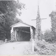
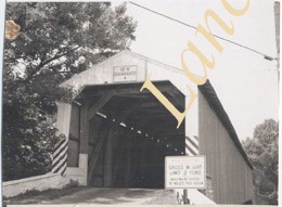
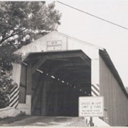
Covered bridge on the Little Conestoga Creek south of Maple Grove at Stoneroads Mill. This bridge was replaced and is the first privately owned bridge in county. George Mann, owner. Located between Lancaster and Manor townships.
Provenance
Lancaster County covered bridge photos taken by M. E. Schroll and Kathryn L. Sauder taken between 1956 and 1958.
Date Range
August 13, 1958
Storage Location
LancasterHistory, Lancaster, PA
People
Mann, George
Subcategory
Documentary Artifact
Search Terms
Covered bridges
Little Conestoga Creek
Maple Grove
Stoneroad's Mill
Lancaster Twp.
Manor Twp.
Object Name
Print, Photographic
Print Size
3.5 x 4.5 inches
Condition
Good
Object ID
1-09-04-11
Images
Less detail

10 records – page 1 of 1.