Historic structures Survey and Determination of Eligibility Report : East Lampeter, Leacock, Strasburg, Paradise, Salisbury, and Sadsbury Townships, Lancaster County, Pensylvania
Prepared for Pennsylvania Department of Transportation, Engineering District 8-0.
CD inserted in envelope in back of v.1.
Contents
Project need and description--Description of the area of potential effect--Methodology--Summary of previous documentation--Results of reconnaissance survey--Historical overview--Agricultural context--Community development context--Industrial context--Transportation context--Tourism context--Survey and report methodology.
Chapters: People and cultures -- Community -- Education -- Transportation -- Transportation at work -- Business and industry.
Summary
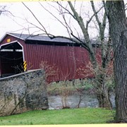
Archival photographs are used to tell the story of these Lancaster County communities - the people and their culture, community, education, transportation, business, and industry.
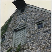
Photograph- Compass Mill at the intersection of Pierson Road and Rothsville Road (Route 772) just outside of Lititz. Built by the Moravian Congregation c. 1755.
Photograph- Compass Mill at the intersection of Pierson Road and Rothsville Road (Route 772) just outside of Lititz. Built by the Moravian Congregation c. 1755.
Description
Compass Mill at the intersection of Pierson Road and Rothsville Road (Route 772) just outside of Lititz. Built by the Moravian Congregation c. 1755.
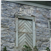
Photograph- Detail of Compass Mill at the intersection of Pierson Road and Rothsville Road (Route 772) just outside of Lititz. Built by the Moravian Congregation c. 1755.
Photograph- Detail of Compass Mill at the intersection of Pierson Road and Rothsville Road (Route 772) just outside of Lititz. Built by the Moravian Congregation c. 1755.
Description
Detail of Compass Mill at the intersection of Pierson Road and Rothsville Road (Route 772) just outside of Lititz. Built by the Moravian Congregation c. 1755.