It appears no script is enabled within your browser. Please enable JavaScript to use this site.
Skip header and navigation
Toggle navigation
Collections
Search
Help
Privacy
Your Selections:
0
Items
Staff Login
Revise Search
Revise Search
Revise search
Search
Data Source
Library
3
×
Data Source
All
A
B
C
D
E
F
G
H
I
J
K
L
M
N
O
P
Q
R
S
T
U
V
W
X
Y
Z
Sort
By Count
Alphabetical
Filtered by
Filter
Loading...
Subject
Lancaster County (Pa.) - Maps.
2
Cemeteries - Pennsylvania - Lancaster
1
Chester County (Pa.) - Maps.
1
Conestoga Traction Company.
1
Delaware County (Pa.) - Maps.
1
Electric railroads - Pennsylvania - Lancaster County - Maps.
1
Lancaster (Pa.) - Maps.
1
Lancaster County (Pa.) - Population - Maps.
1
Roads - Pennsylvania - Chester County - Maps.
1
Roads - Pennsylvania - Delaware County - Maps.
1
Roads - Pennsylvania - Lancaster County - Maps.
1
Woodward Hill cemetery (Lancaster, Pa.) - Maps.
1
More
×
Subject
All
A
B
C
D
E
F
G
H
I
J
K
L
M
N
O
P
Q
R
S
T
U
V
W
X
Y
Z
Sort
By Count
Alphabetical
Filtered by
Filter
Loading...
Name
Conestoga Traction Company.
1
Eshleman, H. Frank
1
×
Name
All
A
B
C
D
E
F
G
H
I
J
K
L
M
N
O
P
Q
R
S
T
U
V
W
X
Y
Z
Sort
By Count
Alphabetical
Filtered by
Filter
Loading...
Decade
1760s
1
1800s
1
1810s
1
1820s
2
1840s
1
1850s
1
1880s
4
1890s
5
1900s
1910s
4
1920s
8
1930s
20
1940s
10
1950s
15
1960s
27
1970s
15
1980s
11
1990s
11
2000s
15
×
Decade
All
A
B
C
D
E
F
G
H
I
J
K
L
M
N
O
P
Q
R
S
T
U
V
W
X
Y
Z
Sort
By Count
Alphabetical
Filtered by
Filter
Loading...
Material
Bond, Legal
1092
Documents
967
Probate
644
Order for Payment
570
Appraisal
442
Text
207
Archive
69
Print, Photographic
66
Blueprint
6
Scrapbook
6
Transparency, Lantern Slide
6
Petition
5
More
×
Material
All
A
B
C
D
E
F
G
H
I
J
K
L
M
N
O
P
Q
R
S
T
U
V
W
X
Y
Z
Sort
By Count
Alphabetical
Filtered by
Filter
Loading...
Online Media
PDF
2
×
Online Media
All
A
B
C
D
E
F
G
H
I
J
K
L
M
N
O
P
Q
R
S
T
U
V
W
X
Y
Z
Sort
By Count
Alphabetical
Filtered by
Filter
Loading...
Advanced Search
Help
more like: 4C9D845C-21CA-48CE-BB22-060246346758
Cartographic
1900s
Sorted by
Relevance
Sort by Title
Expand All
Collapse All
List View
Gallery View
Print
3 records – page 1 of 1.
Prev
Next
Toggle Full Record
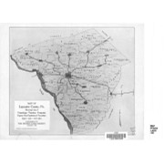
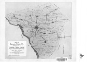
Map of Lancaster County, Pa. showing lines of Conestoga Traction Company
https://collections.lancasterhistory.org/en/permalink/lhdo15838
Corporate Author
Conestoga Traction Company.
Date of Publication
1909.
Call Number
974.815 LACO 141
More detail
1 document
Responsibility
courtesy, Conestoga Traction Company.
Corporate Author
Conestoga Traction Company.
Place of Publication
[Lititz, Pa
Publisher
Express Printing Co.,],
Date of Publication
1909.
Physical Description
1 map ; 23 x 27 cm.
Notes
Scale on map: 1 in. = 4.61 miles.
"Supplement of the Pennsylvania German, August, 1909."
"Figures give population of townships."
Reduced reprinting of original map.
Subjects
Conestoga Traction Company.
Electric railroads - Pennsylvania - Lancaster County - Maps.
Lancaster County (Pa.) - Population - Maps.
Lancaster County (Pa.) - Maps.
Location
Lancaster History Library - Map
Call Number
974.815 LACO 141
Documents
map_974.815_LACO_141_.pdf
Read PDF
Download PDF
Less detail
More Like This
Permalink
Toggle Full Record
Plan of Woodward Hill Cemetery, Lancaster, Pa
https://collections.lancasterhistory.org/en/permalink/lhdo3292
Date of Publication
[ca. 1900].
Call Number
974.815 LACI 703
More detail
Place of Publication
[S.l.]
Publisher
[s.n.] ,
Date of Publication
[ca. 1900].
Physical Description
1 map : photocopy : 58 x 80 cm.
Notes
Gives section and lot numbers.
Subjects
Woodward Hill cemetery (Lancaster, Pa.) - Maps.
Cemeteries - Pennsylvania - Lancaster
Lancaster (Pa.) - Maps.
Location
Lancaster History Library - Map
Call Number
974.815 LACI 703
Less detail
More Like This
Permalink
Toggle Full Record
Map showing location and date of the earliest highways leading from the Delaware and Schulkill Rivers to the Susquehanna River and it's branches / by H. Frank Eshleman
https://collections.lancasterhistory.org/en/permalink/lhdo15534
Author
Eshleman, H. Frank
Date of Publication
1907.
Call Number
974.815 SEPA 100
More detail
1 document
Author
Eshleman, H. Frank
Place of Publication
Lancaster, Pa
Publisher
H. Frank Eshleman,
Date of Publication
1907.
Physical Description
1 map ; 22 x 41 cm.
Notes
Scale on map [ca. 1:418,176]. 3/4 in. = 5 mi.
May be a reduced reproduction of the original map.
Subjects
Roads - Pennsylvania - Lancaster County - Maps.
Roads - Pennsylvania - Chester County - Maps.
Roads - Pennsylvania - Delaware County - Maps.
Lancaster County (Pa.) - Maps.
Chester County (Pa.) - Maps.
Delaware County (Pa.) - Maps.
Location
Lancaster History Library - Map
Call Number
974.815 SEPA 100
Documents
map_974.815_SEPA_100_.pdf
Read PDF
Download PDF
Less detail
More Like This
Permalink