It appears no script is enabled within your browser. Please enable JavaScript to use this site.
Skip header and navigation
Toggle navigation
Collections
Search
Help
Privacy
Your Selections:
0
Items
Staff Login
Revise Search
Revise Search
Revise search
Search
Data Source
Photographs
19075
Archives
10747
Artifacts
17
×
Data Source
All
A
B
C
D
E
F
G
H
I
J
K
L
M
N
O
P
Q
R
S
T
U
V
W
X
Y
Z
Sort
By Count
Alphabetical
Filtered by
Filter
Loading...
Collection
Administrators Accounts
32306
Indictments
29668
Quarter Sessions
27507
General Collection
Liquor License Papers
Lancaster Recreation Commission Photograph Collection
9102
Henry Kauffman Photograph Collection
7180
Darmstaetter Collection
6906
Renunciations
6633
Commissioners' Orders for Payment
5322
Heritage Center Collection
5280
Mayor's Court
3550
More
×
Collection
All
A
B
C
D
E
F
G
H
I
J
K
L
M
N
O
P
Q
R
S
T
U
V
W
X
Y
Z
Sort
By Count
Alphabetical
Filtered by
Filter
Loading...
Subject
Documentary Artifact
26955
Liquor License
1662
Lancaster
1015
Railroads
632
Military
607
Susquehanna River
559
Portraits
531
Construction
526
Covered bridges
472
Education
454
Agriculture
441
Bridges
430
More
×
Subject
All
A
B
C
D
E
F
G
H
I
J
K
L
M
N
O
P
Q
R
S
T
U
V
W
X
Y
Z
Sort
By Count
Alphabetical
Filtered by
Filter
Loading...
Name
Heiges, George L.
423
Merchant, Robert
395
Rothwell, Gerald
379
Hostetter, Harry B.
335
Thompson, Robert Hugh Sr.
324
Darmstaetter's
258
Saylor, B. Frank
231
Bond, George Ross
223
Einolf, Albert L.
189
Moe, Carlton F. Jr.
160
Loose, John Ward Willson
110
Miesse, D. Walter
105
More
×
Name
All
A
B
C
D
E
F
G
H
I
J
K
L
M
N
O
P
Q
R
S
T
U
V
W
X
Y
Z
Sort
By Count
Alphabetical
Filtered by
Filter
Loading...
Place
Lancaster
6716
Columbia
848
Manheim Twp.
570
Conestoga Twp.
556
Marietta
535
Martic Twp.
476
Lancaster Twp.
474
East Hempfield Twp.
436
Manor Twp.
424
Manheim
307
Drumore Twp.
294
Salisbury Twp.
291
More
×
Place
All
A
B
C
D
E
F
G
H
I
J
K
L
M
N
O
P
Q
R
S
T
U
V
W
X
Y
Z
Sort
By Count
Alphabetical
Filtered by
Filter
Loading...
Decade
1070s
1
1740s
1
1750s
8
1760s
102
1770s
43
1780s
82
1790s
28
1800s
109
1810s
981
1820s
783
1830s
2080
1840s
2052
1850s
2294
1860s
2412
1870s
107
1880s
153
1890s
315
1900s
529
1910s
914
1920s
1143
1930s
849
1940s
655
1950s
847
1960s
899
1970s
1207
1980s
623
1990s
1156
2000s
982
2010s
13
×
Decade
All
A
B
C
D
E
F
G
H
I
J
K
L
M
N
O
P
Q
R
S
T
U
V
W
X
Y
Z
Sort
By Count
Alphabetical
Filtered by
Filter
Loading...
Material
Print, Photographic
17308
Documents
6036
Petition
4688
Negative
1278
Negative, Glass Plate
321
Tintype
76
Transparency, Slide
58
Bond
19
Daguerreotype
11
Slide
8
Ambrotype
5
Filmstrip
4
More
×
Material
All
A
B
C
D
E
F
G
H
I
J
K
L
M
N
O
P
Q
R
S
T
U
V
W
X
Y
Z
Sort
By Count
Alphabetical
Filtered by
Filter
Loading...
Archival Hierarchy
Item
10747
×
Archival Hierarchy
All
A
B
C
D
E
F
G
H
I
J
K
L
M
N
O
P
Q
R
S
T
U
V
W
X
Y
Z
Sort
By Count
Alphabetical
Filtered by
Filter
Loading...
Online Media
Image
19041
PDF
32
×
Online Media
All
A
B
C
D
E
F
G
H
I
J
K
L
M
N
O
P
Q
R
S
T
U
V
W
X
Y
Z
Sort
By Count
Alphabetical
Filtered by
Filter
Loading...
Advanced Search
Help
more like: 4D4B7B3F-343C-4B3B-A79F-057038769271
Liquor License Papers
General Collection
Sorted by
Relevance
Sort by Title
Expand All
Collapse All
List View
Gallery View
Print
10 records – page 1 of 1.
Prev
Next
Toggle Full Record
Print, Photographic
https://collections.lancasterhistory.org/en/permalink/dc60721a-a071-4b05-8fda-985474912171
Collection
General Collection
Object ID
1-09-05-70
More detail
1 image
Object Name
Print, Photographic
Collection
General Collection
Description
White Rock Forge bridge between Colerain and Little Britain Townships on the west branch of the Octoraro Creek. 87 feet long, built in 1847.
Provenance
digital image only - original owned by Milton Haldeman
Storage Location
LancasterHistory, Lancaster, PA
Subcategory
Documentary Artifact
Search Terms
Bridges
Covered bridges
Forges
Octoraro Creek, West Branch
White Rock Covered Bridge
White Rock Forge
White Rock Forge Covered Bridge
White Rock, Little Britain Twp.
Object Name
Print, Photographic
Condition
Good
Object ID
1-09-05-70
Images
Less detail
More Like This
Permalink
Toggle Full Record
Print, Photographic
https://collections.lancasterhistory.org/en/permalink/af92c87a-dc01-4c78-880b-576538320764
Collection
General Collection
Object ID
1-10-03-73
Date Range
August 27, 2000
More detail
1 image
Object Name
Print, Photographic
Collection
General Collection
Description
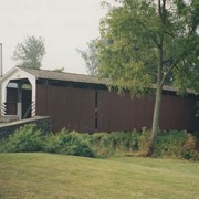
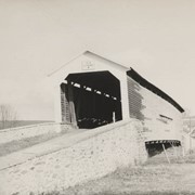
White Rock covered bridge over Octoraro Creek.
Date Range
August 27, 2000
Storage Location
LancasterHistory, Lancaster, PA
Subcategory
Documentary Artifact
Search Terms
Bridges
Colerain Twp.
Covered bridges
Creeks
Octoraro Creek, West Branch
White Rock Covered Bridge
White Rock Forge Covered Bridge
White Rock, Little Britain Twp.
Object Name
Print, Photographic
Print Size
4 x 6 inches
Object ID
1-10-03-73
Images
Less detail
More Like This
Permalink
Toggle Full Record
Print, Photographic
https://collections.lancasterhistory.org/en/permalink/adf748a2-38eb-4fbc-9b00-493564116246
Collection
General Collection
Title
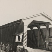
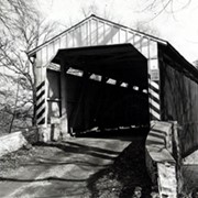
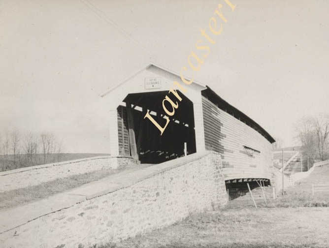
Photograph- White Rock covered bridge over the West Branch of the Octoraro Creek between Colerain and Little Britain townships.
Object ID
1-09-03-53
Date Range
September 1956
More detail
1 image
Object Name
Print, Photographic
Collection
General Collection
Title
Photograph- White Rock covered bridge over the West Branch of the Octoraro Creek between Colerain and Little Britain townships.
Description
White Rock covered bridge over the West Branch of the Octoraro Creek between Colerain and Little Britain townships.
Provenance
Lancaster County covered bridge photos taken by M. E. Schroll and Kathryn L. Sauder taken between 1956 and 1958.
Date Range
September 1956
Storage Location
LancasterHistory, Lancaster, PA
Subcategory
Documentary Artifact
Search Terms
Bridges
Colerain Twp.
Covered bridges
Creeks
Octoraro Creek, West Branch
White Rock Covered Bridge
White Rock Forge Covered Bridge
White Rock, Little Britain Twp.
Object Name
Print, Photographic
Print Size
3.5 x 3.5 inches
Condition
Good
Object ID
1-09-03-53
Images
Less detail
More Like This
Permalink
Toggle Full Record
Print, Photographic
https://collections.lancasterhistory.org/en/permalink/aee09825-bd3d-4c64-85d9-210349253712
Collection
General Collection
Title
Photograph- White Rock covered bridge over the West Branch of the Octoraro Creek between Colerain and Little Britain townships.
Object ID
1-09-03-54
Date Range
August 4, 1958
More detail
1 image
Object Name
Print, Photographic
Collection
General Collection
Title
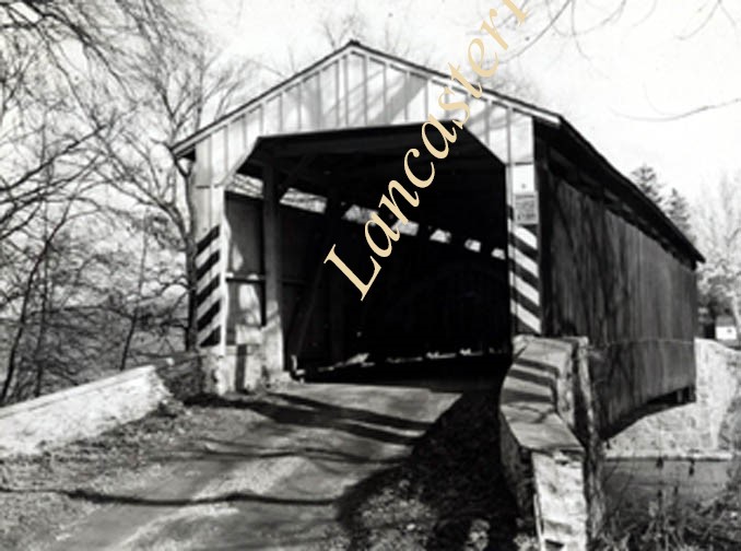
Photograph- White Rock covered bridge over the West Branch of the Octoraro Creek between Colerain and Little Britain townships.
Description
White Rock covered bridge over the West Branch of the Octoraro Creek between Colerain and Little Britain townships.
Provenance
Lancaster County covered bridge photos taken by M. E. Schroll and Kathryn L. Sauder taken between 1956 and 1958.
Date Range
August 4, 1958
Storage Location
LancasterHistory, Lancaster, PA
Subcategory
Documentary Artifact
Search Terms
Bridges
Colerain Twp.
Covered bridges
Creeks
Octoraro Creek, West Branch
White Rock Covered Bridge
White Rock Forge Covered Bridge
White Rock, Little Britain Twp.
Object Name
Print, Photographic
Print Size
3.5 x 3.5 inches
Condition
Good
Object ID
1-09-03-54
Images
Less detail
More Like This
Permalink
Toggle Full Record
Transparency, Slide
https://collections.lancasterhistory.org/en/permalink/338e33e9-2517-42eb-b71b-299425590671
Collection
General Collection
Object ID
5-03-06-41
Date Range
1962
More detail
1 image
Object Name
Transparency, Slide
Collection
General Collection
Description
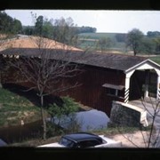
White Rock Forge Covered Bridge over West Octoraro Creek.
Date Range
1962
Creator
Einolf, Albert L.
Storage Location
LancasterHistory, Lancaster, PA
Search Terms
Bridges
Colerain Twp.
Covered bridges
Creeks
Forges
Octoraro Creek, West Branch
West Octoraro Creek
White Rock Covered Bridge
White Rock Forge Covered Bridge
Place
Colerain Twp.
Object Name
Transparency, Slide
Film Size
35 mm
Object ID
5-03-06-41
Images
Less detail
More Like This
Permalink
Toggle Full Record
Print, Photographic
https://collections.lancasterhistory.org/en/permalink/16218ea5-4cd8-4393-9f9b-165940332110
Collection
General Collection
Object ID
1-09-05-60
More detail
1 image
Object Name
Print, Photographic
Collection
General Collection
Description
Daniel Good's Fording bridge one mile northeast of Marticville in Martic Township on Pequea Creek. 79 feet long, built in 1855.
Provenance
digital image only - original owned by Milton Haldeman
Storage Location
LancasterHistory, Lancaster, PA
People
Good, Daniel
Subcategory
Documentary Artifact
Search Terms
Good's Fording Bridge
Covered bridges
Pequea Creek
Martic Twp.
Marticville, Martic Twp.
Place
Martic Twp.
Object Name
Print, Photographic
Condition
Good
Object ID
1-09-05-60
Images
Less detail
More Like This
Permalink
Toggle Full Record
Print, Photographic
https://collections.lancasterhistory.org/en/permalink/682a9434-ba57-460c-803b-469885138602
Collection
General Collection
Object ID
2-24-04-17
More detail
1 image
Object Name
Print, Photographic
Collection
General Collection
Description
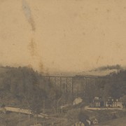
View of Martic Forge with railroad trestle, covered bridge and Kepler Lodge.
Storage Location
LancasterHistory, Lancaster, PA
Subcategory
Documentary Artifact
Search Terms
Martic Forge, Martic Twp.
Railroads
Covered bridges
Kepler Lodge
Trestles
Place
Martic Twp.
Object Name
Print, Photographic
Print Size
5 x 8 inches
Condition
Fair
Object ID
2-24-04-17
Images
Less detail
More Like This
Permalink
Toggle Full Record
Print, Photographic
https://collections.lancasterhistory.org/en/permalink/6b1ad600-57fb-42ec-afbc-338984445400
Collection
General Collection
Object ID
1-09-03-71
Date Range
August 1958
More detail
1 image
Object Name
Print, Photographic
Collection
General Collection
Description
Poole Forge bridge on the Conestoga River near Churchtown.
Provenance
Lancaster County covered bridge photos taken by M. E. Schroll and Kathryn L. Sauder taken between 1956 and 1958.
Date Range
August 1958
Storage Location
LancasterHistory, Lancaster, PA
Subcategory
Documentary Artifact
Search Terms
Poole Forge bridge
Conestoga River
Covered bridges
Churchtown, Caernarvon Twp.
Place
Caernarvon Twp.
Object Name
Print, Photographic
Print Size
3.5 x 3.5 inches
Condition
Good
Object ID
1-09-03-71
Images
Less detail
More Like This
Permalink
Toggle Full Record
Print, Photographic
https://collections.lancasterhistory.org/en/permalink/9896c808-2b88-460d-a29e-257849661545
Collection
General Collection
Object ID
1-09-05-66
More detail
1 image
Object Name
Print, Photographic
Collection
General Collection
Description
Bell Bank Bridge, two and a half miles east of Union in Colerain Township on the Octoraro Creek. 131 feet long, built in 1861.
Provenance
digital image only - original owned by Milton Haldeman
Storage Location
LancasterHistory, Lancaster, PA
Subcategory
Documentary Artifact
Search Terms
Bell Bank Covered Bridge
Bell Bank, Colerain Twp.
Bridges
Covered bridges
Creeks
Octoraro Creek, East Branch
Upper Oxford Twp., Chester County, Pennsylvania
Union, Colerain Twp.
Place
Colerain Twp.
Object Name
Print, Photographic
Condition
Good
Object ID
1-09-05-66
Images
Less detail
More Like This
Permalink
Toggle Full Record
Print, Photographic
https://collections.lancasterhistory.org/en/permalink/d47354d5-8b64-48e4-8369-939331091300
Collection
General Collection
Object ID
1-09-03-87
Date Range
August 1956
More detail
1 image
Object Name
Print, Photographic
Collection
General Collection
Description
Wabank Mill Bridge, also called Third Lock Bridge, on the Conestoga River between Lancaster and Pequea townships.
Provenance
Lancaster County covered bridge photos taken by M. E. Schroll and Kathryn L. Sauder taken between 1956 and 1958.
Date Range
August 1956
Storage Location
LancasterHistory, Lancaster, PA
Subcategory
Documentary Artifact
Search Terms
Bridges
Conestoga River
Covered bridges
Creeks
Lancaster Twp.
Mills
Pequea Twp.
Third Lock Bridge
Wabank Mill
Wabank Mill Bridge
Object Name
Print, Photographic
Print Size
3.5 x 3.5 inches
Condition
Good
Object ID
1-09-03-87
Images
Less detail
More Like This
Permalink
10 records – page 1 of 1.
Prev
Next