It appears no script is enabled within your browser. Please enable JavaScript to use this site.
Skip header and navigation
Toggle navigation
Collections
Search
Help
Privacy
Your Selections:
0
Items
Staff Login
Revise Search
Revise Search
Revise search
Search
Data Source
Photographs
49
×
Data Source
All
A
B
C
D
E
F
G
H
I
J
K
L
M
N
O
P
Q
R
S
T
U
V
W
X
Y
Z
Sort
By Count
Alphabetical
Filtered by
Filter
Loading...
Collection
Barton Mill Photograph Collection
20
General Collection
11
Covered Bridge Safari Album
6
Churches Album
3
Gerald High Schoolhouse Photo Album
3
Leon Landis Album 6
3
Mills Album
2
William Byron Hornberger Photograph Collection
1
×
Collection
All
A
B
C
D
E
F
G
H
I
J
K
L
M
N
O
P
Q
R
S
T
U
V
W
X
Y
Z
Sort
By Count
Alphabetical
Filtered by
Filter
Loading...
Subject
Documentary Artifact
23
West Earl Twp.
20
Mills
18
Brownstown, West Earl Twp.
13
Bridges
10
Covered bridges
9
Conestoga River
8
West Earl Mill
8
Conestoga Creek
6
Rose Hill Bridge
6
Rose Hill Road
6
Wenger's Mill Bridge
6
More
×
Subject
All
A
B
C
D
E
F
G
H
I
J
K
L
M
N
O
P
Q
R
S
T
U
V
W
X
Y
Z
Sort
By Count
Alphabetical
Filtered by
Filter
Loading...
Name
Barton, R. Harold
13
Rineer, Amos Hunter Jr.
3
Wolf, Jacob
3
Bond, G. Ross
2
Krone, Herbert Brickley
2
Wolf, J. H.
2
Bond, George Ross
1
Daisy, Brown
1
Frank, Louise
1
Goldthwait, Anna Hornberger
1
Hornberger, Anna
1
Mumma, J. L.
1
More
×
Name
All
A
B
C
D
E
F
G
H
I
J
K
L
M
N
O
P
Q
R
S
T
U
V
W
X
Y
Z
Sort
By Count
Alphabetical
Filtered by
Filter
Loading...
Place
East Hempfield Twp.
361
Lancaster Twp.
230
Manheim Twp.
101
Conestoga Twp.
97
Leacock Twp.
85
West Cocalico Twp.
74
Martic Twp.
68
Elizabeth Twp.
59
Rapho Twp.
58
Paradise Twp.
53
East Lampeter Twp.
50
West Earl Twp.
More
×
Place
All
A
B
C
D
E
F
G
H
I
J
K
L
M
N
O
P
Q
R
S
T
U
V
W
X
Y
Z
Sort
By Count
Alphabetical
Filtered by
Filter
Loading...
Decade
1890s
1
1910s
3
1920s
3
1930s
3
1950s
4
1990s
3
2000s
6
×
Decade
All
A
B
C
D
E
F
G
H
I
J
K
L
M
N
O
P
Q
R
S
T
U
V
W
X
Y
Z
Sort
By Count
Alphabetical
Filtered by
Filter
Loading...
Material
Print, Photographic
46
Postcard
3
×
Material
All
A
B
C
D
E
F
G
H
I
J
K
L
M
N
O
P
Q
R
S
T
U
V
W
X
Y
Z
Sort
By Count
Alphabetical
Filtered by
Filter
Loading...
Online Media
Image
×
Online Media
All
A
B
C
D
E
F
G
H
I
J
K
L
M
N
O
P
Q
R
S
T
U
V
W
X
Y
Z
Sort
By Count
Alphabetical
Filtered by
Filter
Loading...
Advanced Search
Help
more like: 4FE37F13-BD4D-4B31-8162-371829275138
Image
West Earl Twp.
Sorted by
Relevance
Sort by Title
Expand All
Collapse All
List View
Gallery View
Print
10 records – page 1 of 1.
Prev
Next
Toggle Full Record
Print, Photographic
https://collections.lancasterhistory.org/en/permalink/27b9ee9d-14fc-492e-bcc1-449234236244
Collection
General Collection
Object ID
1-13-05-68
Date Range
c. 1930
More detail
1 image
Object Name
Print, Photographic
Collection
General Collection
Description
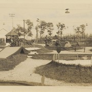
Miniature golf course at Schaum's Corner owned by Carl Weaver.
Provenance
Gift of Gary Hawbaker
Date Range
c. 1930
Storage Location
LancasterHistory, Lancaster, PA
Subcategory
Documentary Artifact
Search Terms
Miniature golf
Recreation
Schaum's Corner, West Earl Twp.
Place
West Earl Twp.
Object Name
Print, Photographic
Print Size
2 x 4 inches
Object ID
1-13-05-68
Images
Less detail
More Like This
Permalink
Toggle Full Record
Print, Photographic
https://collections.lancasterhistory.org/en/permalink/bc6aadeb-3dc8-4e6e-8df5-158830826700
Collection
General Collection
Object ID
1-13-05-71
Date Range
c. 1930
More detail
1 image
Object Name
Print, Photographic
Collection
General Collection
Description
Carl Weaver in ticket booth at his miniature golf course at Schaum's Corner. Signs for restaurant and restrooms in background.
Provenance
Gift of Gary Hawbaker
Date Range
c. 1930
Storage Location
LancasterHistory, Lancaster, PA
People
Weaver, Carl
Subcategory
Documentary Artifact
Search Terms
Miniature golf
Recreation
Schaum's Corner, West Earl Twp.
Place
West Earl Twp.
Object Name
Print, Photographic
Print Size
2 x 4 inches
Object ID
1-13-05-71
Images
Less detail
More Like This
Permalink
Toggle Full Record
Print, Photographic
https://collections.lancasterhistory.org/en/permalink/16ded049-92fc-4798-bd18-640123179700
Collection
General Collection
Object ID
1-13-05-74
Date Range
c. 1930
More detail
1 image
Object Name
Print, Photographic
Collection
General Collection
Description
Carl Weaver at the miniature golf course he owned at Schaum's Corner.
Provenance
Gift of Gary Hawbaker
Date Range
c. 1930
Storage Location
LancasterHistory, Lancaster, PA
Subcategory
Documentary Artifact
Search Terms
Miniature golf
Recreation
Schaum's Corner, West Earl Twp.
Place
West Earl Twp.
Object Name
Print, Photographic
Print Size
3 x 4 inches
Object ID
1-13-05-74
Images
Less detail
More Like This
Permalink
Toggle Full Record
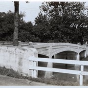
Print, Photographic
https://collections.lancasterhistory.org/en/permalink/cb827489-9f2b-4240-9168-690980811317
Collection
General Collection
Title
Bitzer's Mill Covered Bridge
Object ID
1-21-03-33
Date Range
24 October 1958
More detail
1 image
Object Name
Print, Photographic
Collection
General Collection
Title
Bitzer's Mill Covered Bridge
Description
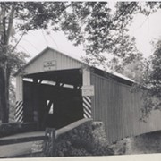
Covered bridge near Fairmount. Possibly Bitzer's Mill Covered Bridge.
Date Range
24 October 1958
Creator
Bond, George Ross
Storage Location
LancasterHistory, Lancaster, PA
Storage Room
Archives West
People
Bond, G. Ross
Subject
Photographs
Classification
1-21-03-33
Search Terms
Covered bridges
Bitzer's Mill Covered Bridge
Fairmount, West Earl Twp.
Conestoga River
Place
West Earl Twp.
Object Name
Print, Photographic
Original or Copy
Original
Print Size
3.25 x 4.75 inches
Dimention Details
Photograph is glued to black paper
Object ID
1-21-03-33
Credit
Courtesy of LancasterHistory, Lancaster, Pennsylvania
Images
Less detail
More Like This
Permalink
Toggle Full Record
Print, Photographic
https://collections.lancasterhistory.org/en/permalink/1ce9d6bd-f66f-44e5-bcb2-888595451860
Collection
General Collection
Title
Rupp's Mill
Object ID
1-21-03-53
Date Range
31 October 1958
More detail
1 image
Object Name
Print, Photographic
Collection
General Collection
Title
Rupp's Mill
Description
Rupp's Mill. Possibly also known as Farmersville Mill.
Date Range
31 October 1958
Storage Location
LancasterHistory, Lancaster, PA
Storage Room
Archives West
People
Bond, G. Ross
Subject
Photographs
Classification
1-21-03-53
Search Terms
Farmersville Mill
Mills
Rupp's Mill
West Earl Twp.
Place
West Earl Twp.
Object Name
Print, Photographic
Original or Copy
Original
Print Size
3.25 x 4.25 inches
Dimention Details
Photograph is glued to black paper
Object ID
1-21-03-53
Credit
Courtesy of LancasterHistory, Lancaster, Pennsylvania
Images
Less detail
More Like This
Permalink
Toggle Full Record
Print, Photographic
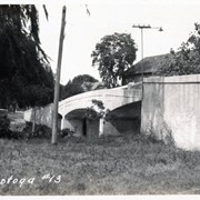
https://collections.lancasterhistory.org/en/permalink/5e93a77a-b151-4c88-95ba-423210273245
Collection
General Collection
Object ID
1-09-03-79
Date Range
August 13, 1958
More detail
1 image
Object Name
Print, Photographic
Collection
General Collection
Description
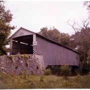
Bitzer's Mill covered bridge, also called Eberly's Cider Mill covered bridge, on the Conestoga River north of Fairmount.
Provenance
Lancaster County covered bridge photos taken by M. E. Schroll and Kathryn L. Sauder taken between 1956 and 1958.
Date Range
August 13, 1958
Storage Location
LancasterHistory, Lancaster, PA
Subcategory
Documentary Artifact
Search Terms
Bitzer's Mill
Covered bridges
Eberly's Cider Mill
Conestoga River
Fairmount, West Earl Twp.
Place
West Earl Twp.
Object Name
Print, Photographic
Print Size
3.5 x 3.5 inches
Condition
Good
Object ID
1-09-03-79
Images
Less detail
More Like This
Permalink
Toggle Full Record
Print, Photographic
https://collections.lancasterhistory.org/en/permalink/b2bafc66-5a5c-4223-af82-341496793242
Collection
General Collection
Object ID
1-09-03-80
Date Range
August 13, 1958
More detail
1 image
Object Name
Print, Photographic
Collection
General Collection
Description
Bitzer's Mill covered bridge, also called Eberly's Cider Mill covered bridge, on the Conestoga River north of Fairmount.
Provenance
Lancaster County covered bridge photos taken by M. E. Schroll and Kathryn L. Sauder taken between 1956 and 1958.
Date Range
August 13, 1958
Storage Location
LancasterHistory, Lancaster, PA
Subcategory
Documentary Artifact
Search Terms
Bitzer's Mill
Covered bridges
Eberly's Cider Mill
Conestoga River
Fairmount, West Earl Twp.
Place
West Earl Twp.
Object Name
Print, Photographic
Print Size
3.5 x 3.5 inches
Condition
Good
Object ID
1-09-03-80
Images
Less detail
More Like This
Permalink
Toggle Full Record
Print, Photographic
https://collections.lancasterhistory.org/en/permalink/a461ca80-cdaf-43db-b3b2-094636121854
Collection
General Collection
Object ID
1-20-04-63
More detail
1 image
Object Name
Print, Photographic
Collection
General Collection
Description
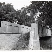
Bridge number 11 over the Conestoga River - at West Farmersville Road and Turtle Hill Road.
Provenance
Photographs taken by Lancaster County during bridge repair work. Gift of Gordon Reed.
Year Range From
1920
Year Range To
1929
Storage Location
LancasterHistory, Lancaster, PA
Search Terms
Bridges
Conestoga River
Farmersville, West Earl Twp.
Place
West Earl Twp.
Object Name
Print, Photographic
Print Size
3.25 x 5.5 inches
Object ID
1-20-04-63
Images
Less detail
More Like This
Permalink
Toggle Full Record
Print, Photographic
https://collections.lancasterhistory.org/en/permalink/1e280d11-9f8a-417f-a74c-261884900646
Collection
General Collection
Object ID
1-20-04-64
More detail
1 image
Object Name
Print, Photographic
Collection
General Collection
Description
Bridge number 12 over the Conestoga River - possibly near Talmage
Provenance
Photographs taken by Lancaster County during bridge repair work. Gift of Gordon Reed.
Year Range From
1920
Year Range To
1929
Storage Location
LancasterHistory, Lancaster, PA
Search Terms
Bridges
Conestoga River
West Earl Twp
Place
West Earl Twp.
Object Name
Print, Photographic
Print Size
3.25 x 5.5 inches
Object ID
1-20-04-64
Images
Less detail
More Like This
Permalink
Toggle Full Record
Print, Photographic
https://collections.lancasterhistory.org/en/permalink/96dc1ba6-121c-4619-9811-455721864178
Collection
General Collection
Object ID
1-20-04-65
More detail
1 image
Object Name
Print, Photographic
Collection
General Collection
Description
Bridge number 13 over the Conestoga River - possibly near Talmage
Provenance
Photographs taken by Lancaster County during bridge repair work. Gift of Gordon Reed.
Year Range From
1920
Year Range To
1929
Storage Location
LancasterHistory, Lancaster, PA
Search Terms
Bridges
Conestoga River
West Earl Twp.
Place
West Earl Twp.
Object Name
Print, Photographic
Print Size
3.25 x 5.5 inches
Object ID
1-20-04-65
Images
Less detail
More Like This
Permalink
10 records – page 1 of 1.
Prev
Next