Skip header and navigation

Revise Search

10 records – page 1 of 1.

Collection
General Collection
Title
Photograph- Eden Mill covered bridge across the Conestoga Creek at Eden, northeast of Lancaster.
Object ID
1-09-03-35
Date Range
July 1956
  1 image  
Object Name
Print, Photographic
Collection
General Collection
Title
Photograph- Eden Mill covered bridge across the Conestoga Creek at Eden, northeast of Lancaster.
Description
Eden Mill covered bridge across the Conestoga Creek at Eden, northeast of Lancaster.
Provenance
Lancaster County covered bridge photos taken by M. E. Schroll and Kathryn L. Sauder taken between 1956 and 1958.
Date Range
July 1956
Storage Location
LancasterHistory, Lancaster, PA
Subcategory
Documentary Artifact
Search Terms
Conestoga River
Eden, Manheim Twp.
Covered bridges
Eden Mill
Place
Manheim Twp.
Object Name
Print, Photographic
Print Size
3.5 x 3.5 inches
Condition
Good
Object ID
1-09-03-35
Images
Less detail
Collection
General Collection
Title
Photograph- Covered bridge across the Octoraro Creek, northwest of Homeville and south of Octoraro.
Object ID
1-09-03-43
Date Range
September 1956
  1 image  
Object Name
Print, Photographic
Collection
General Collection
Title
Photograph- Covered bridge across the Octoraro Creek, northwest of Homeville and south of Octoraro.
Description
Covered bridge across the Octoraro Creek, northwest of Homeville and south of Octoraro.
Provenance
Lancaster County covered bridge photos taken by M. E. Schroll and Kathryn L. Sauder taken between 1956 and 1958.
Date Range
September 1956
Storage Location
LancasterHistory, Lancaster, PA
Subcategory
Documentary Artifact
Search Terms
Octoraro Creek
Homeville, Upper Oxford Twp.
Covered bridges
Place
Colerain Twp.
Object Name
Print, Photographic
Print Size
3.5 x 3.5 inches
Condition
Good
Object ID
1-09-03-43
Images
Less detail
Collection
General Collection
Object ID
1-09-03-81
Date Range
July 1956
  1 image  
Object Name
Print, Photographic
Collection
General Collection
Description
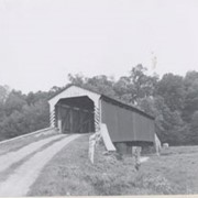
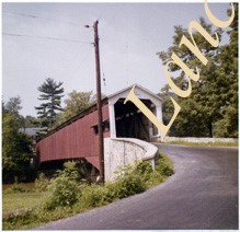
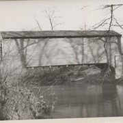
Covered bridge across the Conestoga Creek south of Oregon. Photo is identified as Raub's bridge, but is better known as Pinetown Bridge or Nolt's Point covered bridge.
Provenance
Lancaster County covered bridge photos taken by M. E. Schroll and Kathryn L. Sauder taken between 1956 and 1958.
Date Range
July 1956
Storage Location
LancasterHistory, Lancaster, PA
Subcategory
Documentary Artifact
Search Terms
Covered bridges
Conestoga Creek
Pinetown, Upper Leacock Twp.
Place
Manheim Twp.
Object Name
Print, Photographic
Print Size
3.5 x 3.5 inches
Condition
Good
Object ID
1-09-03-81
Images
Less detail
Collection
General Collection
Object ID
1-09-03-82
Date Range
August 5, 1958
  1 image  
Object Name
Print, Photographic
Collection
General Collection
Description
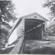
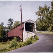
On the Conestoga Creek, Pinetown Road, south of Oregon. Bridge is identified as Raub's bridge but is better known as Pinetown Bridge or Nolt's Point covered bridge.
Provenance
Lancaster County covered bridge photos taken by M. E. Schroll and Kathryn L. Sauder taken between 1956 and 1958.
Date Range
August 5, 1958
Storage Location
LancasterHistory, Lancaster, PA
Subcategory
Documentary Artifact
Search Terms
Conestoga Creek
Covered bridges
Pinetown, Upper Leacock Twp.
Place
Manheim Twp.
Object Name
Print, Photographic
Print Size
3.5 x 3.5 inches
Condition
Good
Object ID
1-09-03-82
Images
Less detail
Collection
General Collection
Object ID
1-09-03-85
Date Range
July 1956
  1 image  
Object Name
Print, Photographic
Collection
General Collection
Description
Binkley's Mill covered bridge across the Conestoga River at Eden, northeast of Lancaster.
Provenance
Lancaster County covered bridge photos taken by M. E. Schroll and Kathryn L. Sauder taken between 1956 and 1958.
Date Range
July 1956
Storage Location
LancasterHistory, Lancaster, PA
Subcategory
Documentary Artifact
Search Terms
Binkley's Mill
Covered bridges
Conestoga River
Eden, Manheim Twp.
Place
Manheim Twp.
Object Name
Print, Photographic
Print Size
3.5 x 3.5 inches
Condition
Good
Object ID
1-09-03-85
Images
Less detail
Collection
General Collection
Object ID
1-09-03-86
Date Range
August 6, 1958
  1 image  
Object Name
Print, Photographic
Collection
General Collection
Description
Binkley's Mill covered bridge on the Conestoga River at Eden.
Provenance
Lancaster County covered bridge photos taken by M. E. Schroll and Kathryn L. Sauder taken between 1956 and 1958.
Date Range
August 6, 1958
Storage Location
LancasterHistory, Lancaster, PA
Subcategory
Documentary Artifact
Search Terms
Binkley's Mill
Covered bridges
Conestoga River
Eden, Manheim Twp.
Place
Manheim Twp.
Object Name
Print, Photographic
Print Size
3.5 x 3.5 inches
Condition
Good
Object ID
1-09-03-86
Images
Less detail
Collection
General Collection
Title
Eden Bridge
Object ID
1-21-03-31
Date Range
31 October 1958
  1 image  
Object Name
Print, Photographic
Collection
General Collection
Title
Eden Bridge
Description
Eden bridge
Date Range
31 October 1958
Creator
Bond, George Ross
Storage Location
LancasterHistory, Lancaster, PA
Storage Room
Archives West
People
Bond, G. Ross
Subject
Photographs
Classification
1-21-03-31
Search Terms
Covered bridges
Eden, Manheim Twp.
Conestoga River
Place
Manheim Twp.
Object Name
Print, Photographic
Original or Copy
Original
Print Size
4 x 5 inches
Dimention Details
Photograph is glued to black paper
Object ID
1-21-03-31
Credit
Courtesy of LancasterHistory, Lancaster, Pennsylvania
Images
Less detail
Collection
Mildred Shopf Smiley Photograph Collection
Object ID
MS-01-04-60
Date Range
August 1955
  1 image  
Object Name
Print, Photographic
Collection
Mildred Shopf Smiley Photograph Collection
Description
Flooding on the Conestoga River at Eden after Hurricane Connie.
Provenance
Gift of Beth Mitten
Date Range
August 1955
Storage Location
LancasterHistory, Lancaster, PA
Subcategory
Documentary Artifact
Search Terms
Floods
Hurricane Connie
Conestoga River
Eden, Manheim Twp.
Place
Manheim Twp.
Object Name
Print, Photographic
Print Size
3.25 x 4 inches
Object ID
MS-01-04-60
Images
Less detail
Collection
Covered Bridge Album
Object ID
A-11-01-35
Date Range
1950
  1 image  
Object Name
Print, Photographic
Collection
Covered Bridge Album
Description
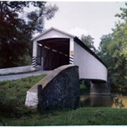
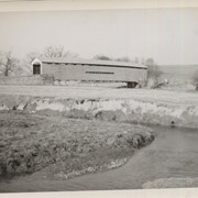
Bellbank Bridge, 2.5 miles east of Union in Colerain Township. State supervised on road LR 36022, built in 1861 (first bridge 1850), single span 131 feet long.
Date Range
1950
Creator
Gaintner, Jay Richard
Storage Location
LancasterHistory, Lancaster, PA
Subcategory
Documentary Artifact
Search Terms
Bridges
Covered bridges
Octoraro Creek
Union, Colerain Twp.
Place
Colerain Twp.
Object Name
Print, Photographic
Print Size
8 x 10 inches
Object ID
A-11-01-35
Images
Less detail
Collection
Covered Bridge Album
Object ID
A-11-01-36
Date Range
1950
  1 image  
Object Name
Print, Photographic
Collection
Covered Bridge Album
Description
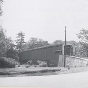
Worth's Bridge, 2.5 miles southeast of Union in Colerain Township. County maintained on road T-764, built in 1857 (first bridge 1841), single span 60 feet long.
Date Range
1950
Creator
Gaintner, Jay Richard
Storage Location
LancasterHistory, Lancaster, PA
Subcategory
Documentary Artifact
Search Terms
Bridges
Covered bridges
Octoraro Creek
Union, Colerain Twp.
Place
Colerain Twp.
Object Name
Print, Photographic
Print Size
8 x 10 inches
Object ID
A-11-01-36
Images
Less detail

10 records – page 1 of 1.