It appears no script is enabled within your browser. Please enable JavaScript to use this site.
Skip header and navigation
Toggle navigation
Collections
Search
Help
Privacy
Your Selections:
0
Items
Staff Login
Revise Search
Revise Search
Revise search
Search
Data Source
Photographs
19096
Artifacts
17
×
Data Source
All
A
B
C
D
E
F
G
H
I
J
K
L
M
N
O
P
Q
R
S
T
U
V
W
X
Y
Z
Sort
By Count
Alphabetical
Filtered by
Filter
Loading...
Collection
Administrators Accounts
32306
Indictments
29668
Quarter Sessions
27515
General Collection
Liquor License Papers
10747
Lancaster Recreation Commission Photograph Collection
9102
Henry Kauffman Photograph Collection
7180
Darmstaetter Collection
6906
Renunciations
6633
Commissioners' Orders for Payment
5322
Heritage Center Collection
5282
Mayor's Court
3550
More
×
Collection
All
A
B
C
D
E
F
G
H
I
J
K
L
M
N
O
P
Q
R
S
T
U
V
W
X
Y
Z
Sort
By Count
Alphabetical
Filtered by
Filter
Loading...
Subject
Documentary Artifact
16770
Railroads
632
Military
607
Susquehanna River
559
Portraits
531
Construction
526
Covered bridges
472
Education
454
Agriculture
441
Bridges
431
Women
421
Houses
419
More
×
Subject
All
A
B
C
D
E
F
G
H
I
J
K
L
M
N
O
P
Q
R
S
T
U
V
W
X
Y
Z
Sort
By Count
Alphabetical
Filtered by
Filter
Loading...
Name
Heiges, George L.
423
Merchant, Robert
395
Rothwell, Gerald
379
Hostetter, Harry B.
335
Thompson, Robert Hugh Sr.
324
Darmstaetter's
258
Saylor, B. Frank
231
Bond, George Ross
223
Einolf, Albert L.
189
Moe, Carlton F. Jr.
160
Loose, John Ward Willson
110
Miesse, D. Walter
105
More
×
Name
All
A
B
C
D
E
F
G
H
I
J
K
L
M
N
O
P
Q
R
S
T
U
V
W
X
Y
Z
Sort
By Count
Alphabetical
Filtered by
Filter
Loading...
Place
Lancaster
5638
Lancaster Twp.
365
Manheim Twp.
326
Conestoga Twp.
325
Manheim
237
Martic Twp.
212
West Lampeter Twp.
183
Manor Twp.
153
Columbia
149
East Donegal Twp.
130
Ephrata
124
East Hempfield Twp.
99
More
×
Place
All
A
B
C
D
E
F
G
H
I
J
K
L
M
N
O
P
Q
R
S
T
U
V
W
X
Y
Z
Sort
By Count
Alphabetical
Filtered by
Filter
Loading...
Decade
1070s
1
1740s
1
1800s
3
1840s
5
1850s
39
1860s
181
1870s
107
1880s
153
1890s
315
1900s
529
1910s
914
1920s
1143
1930s
849
1940s
655
1950s
851
1960s
900
1970s
1207
1980s
623
1990s
1156
2000s
982
2010s
13
×
Decade
All
A
B
C
D
E
F
G
H
I
J
K
L
M
N
O
P
Q
R
S
T
U
V
W
X
Y
Z
Sort
By Count
Alphabetical
Filtered by
Filter
Loading...
Material
Print, Photographic
17308
Negative
1278
Negative, Glass Plate
322
Transparency, Slide
77
Tintype
76
Daguerreotype
11
Slide
8
Ambrotype
5
Stereoview
5
Filmstrip
4
Flag
3
Plate, Commemorative
3
More
×
Material
All
A
B
C
D
E
F
G
H
I
J
K
L
M
N
O
P
Q
R
S
T
U
V
W
X
Y
Z
Sort
By Count
Alphabetical
Filtered by
Filter
Loading...
Online Media
Image
19062
×
Online Media
All
A
B
C
D
E
F
G
H
I
J
K
L
M
N
O
P
Q
R
S
T
U
V
W
X
Y
Z
Sort
By Count
Alphabetical
Filtered by
Filter
Loading...
Advanced Search
Help
more like: 69F030A4-FAF6-466E-A4AD-467078315846
General Collection
Sorted by
Relevance
Sort by Title
Expand All
Collapse All
List View
Gallery View
Print
10 records – page 1 of 1.
Prev
Next
Toggle Full Record
Print, Photographic
https://collections.lancasterhistory.org/en/permalink/4bbec65e-0210-44c9-9eec-452372049972
Collection
General Collection
Object ID
1-09-04-03
Date Range
August 5, 1958
More detail
1 image
Object Name
Print, Photographic
Collection
General Collection
Description
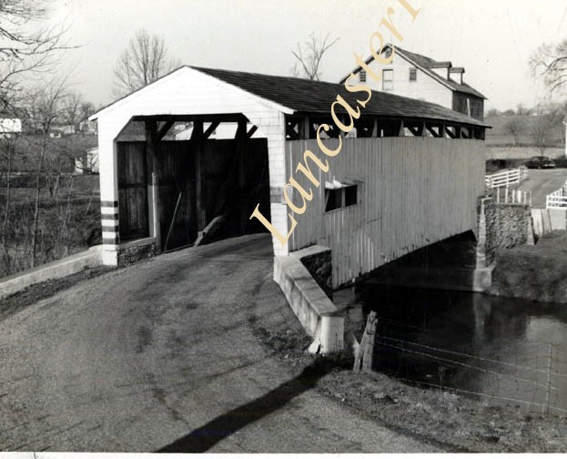
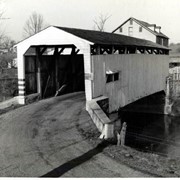
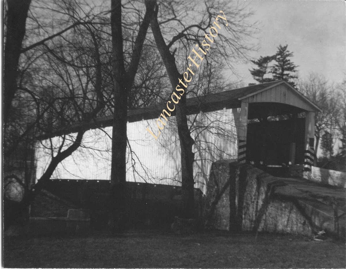
Zook's Mill covered bridge on the Cocalico Creek on Log Cabin Road west of Brownstown between West Earl and Warwick townships.
Provenance
Lancaster County covered bridge photos taken by M. E. Schroll and Kathryn L. Sauder taken between 1956 and 1958.
Date Range
August 5, 1958
Storage Location
LancasterHistory, Lancaster, PA
Subcategory
Documentary Artifact
Search Terms
Bridges
Brownstown, West Earl Twp.
Cocalico Creek
Covered bridges
Creeks
Log Cabin Road
Rose Hill Bridge
Warwick Twp.
West Earl Twp.
Zook's Mill
Object Name
Print, Photographic
Print Size
3.5 x 4.5 inches
Condition
Good
Object ID
1-09-04-03
Images
Less detail
More Like This
Permalink
Toggle Full Record
Print, Photographic
https://collections.lancasterhistory.org/en/permalink/b044a01c-1a7b-4863-9060-374678892714
Collection
General Collection
Object ID
1-20-05-11
More detail
1 image
Object Name
Print, Photographic
Collection
General Collection
Description
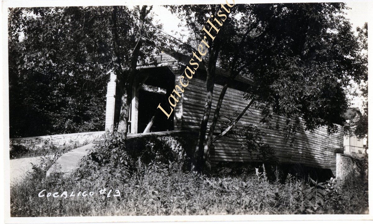
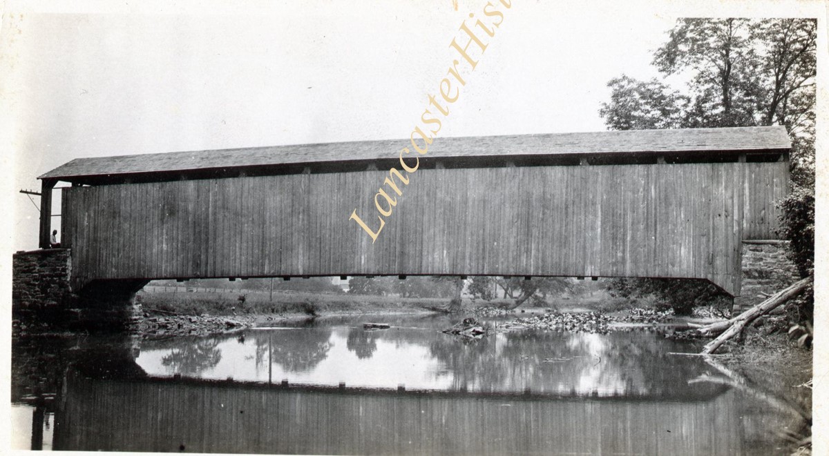
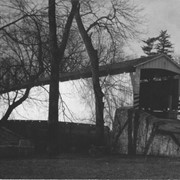
Bridge #13 over Cocalico Creek - Covered bridge on Log Cabin Road known as Zook's Mill Covered Bridge and Rose Hill Covered Bridge
Provenance
Photographs taken by Lancaster County during bridge repair work. Gift of Gordon Reed.
Year Range From
1920
Year Range To
1929
Storage Location
LancasterHistory, Lancaster, PA
Search Terms
Bridges
Cocalico Creek
Covered bridges
Creeks
Log Cabin Road
Rose Hill Bridge
West Earl Twp.
Zook's Mill Bridge
Object Name
Print, Photographic
Print Size
3.25 x 5.5 inches
Object ID
1-20-05-11
Images
Less detail
More Like This
Permalink
Toggle Full Record
Print, Photographic
https://collections.lancasterhistory.org/en/permalink/578a2871-ac76-4a0b-b708-299339706262
Collection
General Collection
Object ID
1-09-05-49
More detail
1 image
Object Name
Print, Photographic
Collection
General Collection
Description
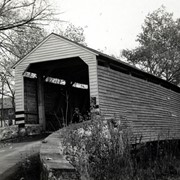
Zook's Mill Bridge on Rose Hill Road near Log Cabin Road between Warwick and West Earl Townships on the Cocalico Creek. 89 feet long, built in 1849.
Provenance
digital image only - original owned by Milton Haldeman
Storage Location
LancasterHistory, Lancaster, PA
Subcategory
Documentary Artifact
Search Terms
Bridges
Cocalico Creek
Covered bridges
Creeks
Log Cabin Road
Rose Hill Road
Warwick Twp.
West Earl Twp.
Zook's Mill
Object Name
Print, Photographic
Condition
Good
Object ID
1-09-05-49
Images
Less detail
More Like This
Permalink
Toggle Full Record
Print, Photographic
https://collections.lancasterhistory.org/en/permalink/1cbf8bcc-3fd9-44c1-abdc-415422047605
Collection
General Collection
Object ID
1-09-05-48
More detail
1 image
Object Name
Print, Photographic
Collection
General Collection
Description
Keller's Mill bridge, also called Guy Bard's bridge, one and a half miles north of Arkon in Ephrata Township on the Cocalico Creek. 76 feet long, built in 1891.
Provenance
digital image only - original owned by Milton Haldeman
Storage Location
LancasterHistory, Lancaster, PA
Subcategory
Documentary Artifact
Search Terms
Keller's Mill Covered Bridge
Guy Bard's Covered Bridge
Akron, Pennsylvania
Cocalico Creek
Covered bridges
Place
Ephrata Twp.
Object Name
Print, Photographic
Condition
Good
Object ID
1-09-05-48
Images
Less detail
More Like This
Permalink
Toggle Full Record
Print, Photographic
https://collections.lancasterhistory.org/en/permalink/e9916c1f-be06-4d7c-ab67-816411519390
Collection
General Collection
Object ID
1-20-04-99
More detail
1 image
Object Name
Print, Photographic
Collection
General Collection
Description
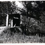
Bridge #2 over Cocalico Creek - possibly Bucher's Mill Covered Bridge
Provenance
Photographs taken by Lancaster County during bridge repair work. Gift of Gordon Reed.
Year Range From
1920
Year Range To
1929
Storage Location
LancasterHistory, Lancaster, PA
Search Terms
Bridges
Bucher's Mill
Bucher's Mill Covered Bridge
Cocalico Creek
Covered bridges
Creeks
East Cocalico Twp.
Mills
Place
East Cocalico Twp.
Object Name
Print, Photographic
Print Size
3.25 x 5.5 inches
Object ID
1-20-04-99
Images
Less detail
More Like This
Permalink
Toggle Full Record
Print, Photographic
https://collections.lancasterhistory.org/en/permalink/d881964c-919a-4aa5-87e9-444742672130
Collection
General Collection
Object ID
1-09-04-01
Date Range
August 5, 1958
More detail
1 image
Object Name
Print, Photographic
Collection
General Collection
Description
Rettew Mill bridge, also called Henry Keller's bridge and Guy Bard's bridge on the Cocalico Creek west of Akron.
Provenance
Lancaster County covered bridge photos taken by M. E. Schroll and Kathryn L. Sauder taken between 1956 and 1958.
Date Range
August 5, 1958
Storage Location
LancasterHistory, Lancaster, PA
People
Keller, Henry
Bard, Guy
Subcategory
Documentary Artifact
Search Terms
Rettew Mill Bridge
Covered bridges
Cocalico Creek
Akron, Pennsylvania
Place
Ephrata Twp.
Object Name
Print, Photographic
Print Size
3.5 x 4.5 inches
Condition
Good
Object ID
1-09-04-01
Images
Less detail
More Like This
Permalink
Toggle Full Record
Print, Photographic
https://collections.lancasterhistory.org/en/permalink/adf748a2-38eb-4fbc-9b00-493564116246
Collection
General Collection
Title
Photograph- White Rock covered bridge over the West Branch of the Octoraro Creek between Colerain and Little Britain townships.
Object ID
1-09-03-53
Date Range
September 1956
More detail
1 image
Object Name
Print, Photographic
Collection
General Collection
Title
Photograph- White Rock covered bridge over the West Branch of the Octoraro Creek between Colerain and Little Britain townships.
Description
White Rock covered bridge over the West Branch of the Octoraro Creek between Colerain and Little Britain townships.
Provenance
Lancaster County covered bridge photos taken by M. E. Schroll and Kathryn L. Sauder taken between 1956 and 1958.
Date Range
September 1956
Storage Location
LancasterHistory, Lancaster, PA
Subcategory
Documentary Artifact
Search Terms
Bridges
Colerain Twp.
Covered bridges
Creeks
Octoraro Creek, West Branch
White Rock Covered Bridge
White Rock Forge Covered Bridge
White Rock, Little Britain Twp.
Object Name
Print, Photographic
Print Size
3.5 x 3.5 inches
Condition
Good
Object ID
1-09-03-53
Images
Less detail
More Like This
Permalink
Toggle Full Record
Print, Photographic
https://collections.lancasterhistory.org/en/permalink/aee09825-bd3d-4c64-85d9-210349253712
Collection
General Collection
Title
Photograph- White Rock covered bridge over the West Branch of the Octoraro Creek between Colerain and Little Britain townships.
Object ID
1-09-03-54
Date Range
August 4, 1958
More detail
1 image
Object Name
Print, Photographic
Collection
General Collection
Title
Photograph- White Rock covered bridge over the West Branch of the Octoraro Creek between Colerain and Little Britain townships.
Description
White Rock covered bridge over the West Branch of the Octoraro Creek between Colerain and Little Britain townships.
Provenance
Lancaster County covered bridge photos taken by M. E. Schroll and Kathryn L. Sauder taken between 1956 and 1958.
Date Range
August 4, 1958
Storage Location
LancasterHistory, Lancaster, PA
Subcategory
Documentary Artifact
Search Terms
Bridges
Colerain Twp.
Covered bridges
Creeks
Octoraro Creek, West Branch
White Rock Covered Bridge
White Rock Forge Covered Bridge
White Rock, Little Britain Twp.
Object Name
Print, Photographic
Print Size
3.5 x 3.5 inches
Condition
Good
Object ID
1-09-03-54
Images
Less detail
More Like This
Permalink
Toggle Full Record
Print, Photographic
https://collections.lancasterhistory.org/en/permalink/af92c87a-dc01-4c78-880b-576538320764
Collection
General Collection
Object ID
1-10-03-73
Date Range
August 27, 2000
More detail
1 image
Object Name
Print, Photographic
Collection
General Collection
Description
White Rock covered bridge over Octoraro Creek.
Date Range
August 27, 2000
Storage Location
LancasterHistory, Lancaster, PA
Subcategory
Documentary Artifact
Search Terms
Bridges
Colerain Twp.
Covered bridges
Creeks
Octoraro Creek, West Branch
White Rock Covered Bridge
White Rock Forge Covered Bridge
White Rock, Little Britain Twp.
Object Name
Print, Photographic
Print Size
4 x 6 inches
Object ID
1-10-03-73
Images
Less detail
More Like This
Permalink
Toggle Full Record
Print, Photographic
https://collections.lancasterhistory.org/en/permalink/67881f03-60cc-42d1-b703-936599532812
Collection
General Collection
Object ID
2-04-04-29
Date Range
1972
More detail
1 image
Object Name
Print, Photographic
Collection
General Collection
Description
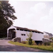
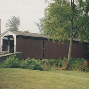
Covered bridge near Log Cabin or Mondamian Farms
Date Range
1972
Creator
Hare, Jim
Storage Location
LancasterHistory, Lancaster, PA
Subcategory
Documentary Artifact
Search Terms
Covered bridges
Log Cabin Road
Zook's Mill Bridge
Cocalico Creek
Place
West Earl Twp.
Object Name
Print, Photographic
Print Size
9.5 x 7.5 inches
Object ID
2-04-04-29
Images
Less detail
More Like This
Permalink
10 records – page 1 of 1.
Prev
Next