It appears no script is enabled within your browser. Please enable JavaScript to use this site.
Skip header and navigation
Toggle navigation
Collections
Search
Help
Privacy
Your Selections:
0
Items
Staff Login
Revise Search
Revise Search
Revise search
Search
Data Source
Photographs
346
×
Data Source
All
A
B
C
D
E
F
G
H
I
J
K
L
M
N
O
P
Q
R
S
T
U
V
W
X
Y
Z
Sort
By Count
Alphabetical
Filtered by
Filter
Loading...
Collection
General Collection
Covered Bridge Album
119
Covered Bridge Safari Album
41
Discover Lancaster Photograph Collection
10
Henry Kauffman Photograph Collection
7
Ed Schopf Safe Harbor Collection
Leon Landis Album 1
2
Diffenderfer Album 1
1
Earl Rebman Photograph Collection
1
Lancaster City and County Scenes Album
1
Lancaster Recreation Commission Photograph Collection
1
Leon Landis Album 5
1
More
×
Collection
All
A
B
C
D
E
F
G
H
I
J
K
L
M
N
O
P
Q
R
S
T
U
V
W
X
Y
Z
Sort
By Count
Alphabetical
Filtered by
Filter
Loading...
Subject
Documentary Artifact
15804
Susquehanna River
779
Dams
576
Railroads
556
Safe Harbor Dam
449
Agriculture
440
Power Plants
439
Stockyards
409
Portraits
405
Military
397
Education
380
Women
369
More
×
Subject
All
A
B
C
D
E
F
G
H
I
J
K
L
M
N
O
P
Q
R
S
T
U
V
W
X
Y
Z
Sort
By Count
Alphabetical
Filtered by
Filter
Loading...
Name
Einolf, Albert L.
18
Bixler, Robert Theodore
14
Bond, George Ross
11
Sachs, Edgar Michael
5
Mann, George
3
Bard, Guy
2
Keller, Henry
2
Lintner, John
2
Schopf, Edward
2
Amway, Jacob
1
Bear, Isaac
1
Buchanan, James
1
More
×
Name
All
A
B
C
D
E
F
G
H
I
J
K
L
M
N
O
P
Q
R
S
T
U
V
W
X
Y
Z
Sort
By Count
Alphabetical
Filtered by
Filter
Loading...
Place
Manheim Twp.
29
Earl Twp.
11
Ephrata Twp.
11
Caernarvon Twp.
10
East Hempfield Twp.
8
Martic Twp.
8
Bart Twp.
7
Rapho Twp.
7
Colerain Twp.
6
East Cocalico Twp.
6
Lancaster
6
Manor Twp.
6
More
×
Place
All
A
B
C
D
E
F
G
H
I
J
K
L
M
N
O
P
Q
R
S
T
U
V
W
X
Y
Z
Sort
By Count
Alphabetical
Filtered by
Filter
Loading...
Decade
1860s
2
1870s
1
1890s
5
1900s
1
1910s
1
1920s
2
1930s
1
1940s
2
1950s
110
1960s
21
1970s
5
1990s
26
2000s
22
×
Decade
All
A
B
C
D
E
F
G
H
I
J
K
L
M
N
O
P
Q
R
S
T
U
V
W
X
Y
Z
Sort
By Count
Alphabetical
Filtered by
Filter
Loading...
Material
Print, Photographic
Negative, Glass Plate
14
Negative
5
×
Material
All
A
B
C
D
E
F
G
H
I
J
K
L
M
N
O
P
Q
R
S
T
U
V
W
X
Y
Z
Sort
By Count
Alphabetical
Filtered by
Filter
Loading...
Online Media
Image
346
×
Online Media
All
A
B
C
D
E
F
G
H
I
J
K
L
M
N
O
P
Q
R
S
T
U
V
W
X
Y
Z
Sort
By Count
Alphabetical
Filtered by
Filter
Loading...
Advanced Search
Help
more like: 79667773-86D0-43F5-9E62-282083174345
Print, Photographic
Ed Schopf Safe Harbor Collection
General Collection
Habeas Corpus Papers
Mechanics' Liens
Covered bridges
Sorted by
Relevance
Sort by Title
Expand All
Collapse All
List View
Gallery View
Print
20 records – page 1 of 1.
Prev
Next
Toggle Full Record
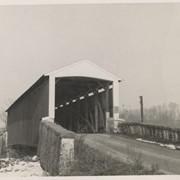
Print, Photographic
https://collections.lancasterhistory.org/en/permalink/4d4b7b3f-343c-4b3b-a79f-057038769271
Collection
General Collection
Object ID
2-04-04-01
More detail
1 image
Object Name
Print, Photographic
Collection
General Collection
Description
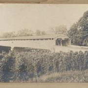
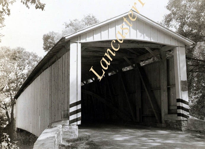
Martic Forge Covered Bridge, built 1884, destroyed by fire in 1919.
Storage Location
LancasterHistory, Lancaster, PA
Subcategory
Documentary Artifact
Search Terms
Martic Forge, Martic Twp.
Bridges
Martic Forge Covered Bridge
Covered bridges
Place
Martic Twp.
Object Name
Print, Photographic
Print Size
7 x 6 inches
Object ID
2-04-04-01
Images
Less detail
More Like This
Permalink
Toggle Full Record
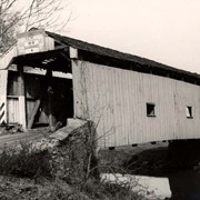
Print, Photographic
https://collections.lancasterhistory.org/en/permalink/4f713eb7-6e95-4c4e-bfdc-421245194080
Collection
General Collection
Object ID
2-04-04-11
More detail
1 image
Object Name
Print, Photographic
Collection
General Collection
Description
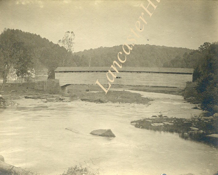
Bridge over Conestoga Creek, built 1841 by Jacob Huber, between Pequea and Manor Townships.
Storage Location
LancasterHistory, Lancaster, PA
People
Huber, Jacob
Subcategory
Documentary Artifact
Search Terms
Covered bridges
Conestoga Creek
Place
Pequea Twp.
Object Name
Print, Photographic
Print Size
10.5 x 8.5 inches
Object ID
2-04-04-11
Images
Less detail
More Like This
Permalink
Toggle Full Record
Print, Photographic
https://collections.lancasterhistory.org/en/permalink/5a3e50b8-d0a6-4d35-8a5d-175449116420
Collection
General Collection
Object ID
2-04-04-20
More detail
1 image
Object Name
Print, Photographic
Collection
General Collection
Description
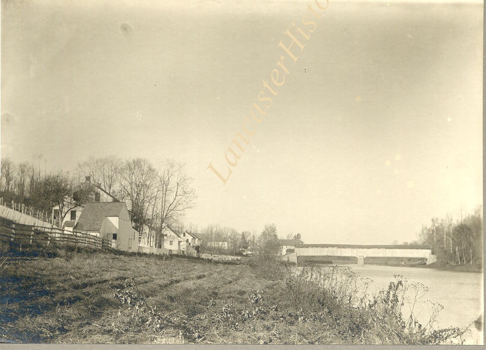
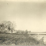
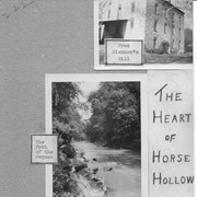
Three photographs on posterboard labeled The Heart of Horse Hollow. Includes Sickman's Mill, The Path of the Pequea and The Old Covered Bridge.
Storage Location
LancasterHistory, Lancaster, PA
Subcategory
Documentary Artifact
Search Terms
Sickman's Mill
Pequea Creek
Covered bridges
Horse Hollow, Conestoga Twp.
Place
Martic Twp.
Object Name
Print, Photographic
Object ID
2-04-04-20
Images
Less detail
More Like This
Permalink
Toggle Full Record
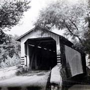
Print, Photographic
https://collections.lancasterhistory.org/en/permalink/67881f03-60cc-42d1-b703-936599532812
Collection
General Collection
Object ID
2-04-04-29
Date Range
1972
More detail
1 image
Object Name
Print, Photographic
Collection
General Collection
Description
Covered bridge near Log Cabin or Mondamian Farms
Date Range
1972
Creator
Hare, Jim
Storage Location
LancasterHistory, Lancaster, PA
Subcategory
Documentary Artifact
Search Terms
Covered bridges
Log Cabin Road
Zook's Mill Bridge
Cocalico Creek
Place
West Earl Twp.
Object Name
Print, Photographic
Print Size
9.5 x 7.5 inches
Object ID
2-04-04-29
Images
Less detail
More Like This
Permalink
Toggle Full Record
Print, Photographic
https://collections.lancasterhistory.org/en/permalink/05dad19d-c474-45c3-89b2-031313553130
Collection
General Collection
Object ID
2-04-01-42
Date Range
1975
More detail
1 image
Object Name
Print, Photographic
Collection
General Collection
Description
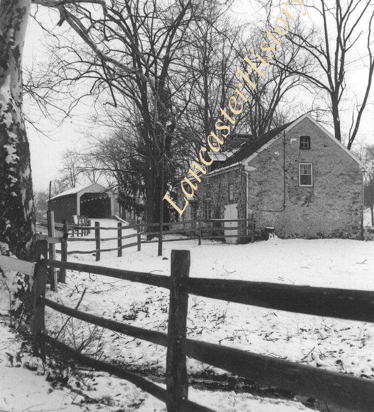
Poole Forge tenant house
Date Range
1975
Storage Location
LancasterHistory, Lancaster, PA
Subcategory
Documentary Artifact
Search Terms
Poole Forge
Covered bridges
Tenant houses
Place
Caernarvon Twp.
Object Name
Print, Photographic
Print Size
5.5 x 6.75 inches
Object ID
2-04-01-42
Images
Less detail
More Like This
Permalink
Toggle Full Record
Print, Photographic
https://collections.lancasterhistory.org/en/permalink/33a839f2-fa4c-49cf-9300-572752392118
Collection
General Collection
Object ID
3-13-01-13
Date Range
1976
More detail
1 image
Object Name
Print, Photographic
Collection
General Collection
Description
"Natural Bridge". Lancaster County Bicentennial Traveling Photo Contest Winners. Covered bridge over creek.
Date Range
1976
Creator
Charles, Jonathan E.
Storage Location
LancasterHistory, Lancaster, PA
Subcategory
Documentary Artifact
Search Terms
Bridges
Covered bridges
Object Name
Print, Photographic
Print Size
13 x 9.5 inches
Dimention Details
Photo on 18 x 14.5 inch mount
Object ID
3-13-01-13
Images
Less detail
More Like This
Permalink
Toggle Full Record
Print, Photographic
https://collections.lancasterhistory.org/en/permalink/f9cb350a-1f95-4dca-a201-572225849490
Collection
General Collection
Object ID
3-12-01-17
Date Range
1976
More detail
1 image
Object Name
Print, Photographic
Collection
General Collection
Description
"Bicycling on a Sunday Afternoon". Lancaster County Bicentennial Traveling Photo Contest Winners. Three people bicycling on a backroad near a covered bridge.
Date Range
1976
Creator
Wechter, Diane
Storage Location
LancasterHistory, Lancaster, PA
Subcategory
Documentary Artifact
Search Terms
Bicycles
Covered bridges
Object Name
Print, Photographic
Print Size
8 x 10 inches
Dimention Details
Photograph on 16 x 20 inch mount
Object ID
3-12-01-17
Images
Less detail
More Like This
Permalink
Toggle Full Record
Print, Photographic
https://collections.lancasterhistory.org/en/permalink/c6507fa6-3821-4a94-8b06-791116392790
Collection
General Collection
Title
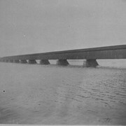
Photograph- Columbia - Wrightsville Bridge from the Wrightsville side of the Susquehanna River. Possibly the bridge burned during the Civil War.
Object ID
1-01-05-36
Date Range
c. 1860
More detail
1 image
Object Name
Print, Photographic
Collection
General Collection
Title
Photograph- Columbia - Wrightsville Bridge from the Wrightsville side of the Susquehanna River. Possibly the bridge burned during the Civil War.
Description
Columbia - Wrightsville Bridge from the Wrightsville side of the Susquehanna River. Possibly the bridge burned during the Civil War.
Date Range
c. 1860
Storage Location
LancasterHistory, Lancaster, PA
Subcategory
Documentary Artifact
Search Terms
Covered bridges
Susquehanna River
Place
Wrightsville, York County, Pennsylvania
Object Name
Print, Photographic
Print Size
7 x 5 inches; 5 x 3.75 inches
Object ID
1-01-05-36
Notes
Two copies.
Images
Less detail
More Like This
Permalink
Toggle Full Record
Print, Photographic
https://collections.lancasterhistory.org/en/permalink/378cf86f-dbb4-42ef-b6f5-152883984720
Collection
General Collection
Title
Photograph- Columbia - Wrightsville Bridge from the Wrightsville side of the Susquehanna River.
Object ID
1-01-05-35
Date Range
c. 1860
More detail
1 image
Object Name
Print, Photographic
Collection
General Collection
Title
Photograph- Columbia - Wrightsville Bridge from the Wrightsville side of the Susquehanna River.
Description
Columbia - Wrightsville Bridge from the Wrightsville side of the Susquehanna River.
Date Range
c. 1860
Storage Location
LancasterHistory, Lancaster, PA
Subcategory
Documentary Artifact
Search Terms
Covered bridges
Susquehanna River
Place
Wrightsville, York County, Pennsylvania
Object Name
Print, Photographic
Film Size
5 x 4 inches
Print Size
7 x 5 inches
Object ID
1-01-05-35
Notes
Two copies.
Negative Number
yes
Images
Less detail
More Like This
Permalink
Toggle Full Record
Print, Photographic
https://collections.lancasterhistory.org/en/permalink/1a1d6000-fdc2-4d39-acd2-216153660729
Collection
General Collection
Object ID
2-07-05-05
Date Range
1896
More detail
1 image
Object Name
Print, Photographic
Collection
General Collection
Description
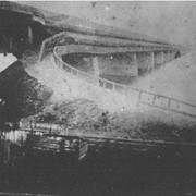
Columbia - Wrightsville Bridge bridge after the hurricane blew it down
Date Range
1896
Storage Location
LancasterHistory, Lancaster, PA
Subcategory
Documentary Artifact
Search Terms
Columbia - Wrightsville Bridge
Covered bridges
Hurricanes
Susquehanna River
Ferries
Place
Columbia
Object Name
Print, Photographic
Object ID
2-07-05-05
Images
Less detail
More Like This
Permalink
Toggle Full Record
Print, Photographic
https://collections.lancasterhistory.org/en/permalink/b26ae1b0-5c9b-4437-a187-905868049146
Collection
General Collection
Title
Photograph- Second Lock Bridge over the Conestoga River.
Object ID
1-06-03-72
More detail
1 image
Object Name
Print, Photographic
Collection
General Collection
Title
Photograph- Second Lock Bridge over the Conestoga River.
Description
Second Lock Bridge over the Conestoga River.
Storage Location
LancasterHistory, Lancaster, PA
Subcategory
Documentary Artifact
Search Terms
Conestoga River
Second Lock Bridge
Covered bridges
Place
Manor Twp.
Object Name
Print, Photographic
Print Size
4 x 5 inches
Condition
Good
Condition Date
edges torn
Object ID
1-06-03-72
Images
Less detail
More Like This
Permalink
Toggle Full Record
Print, Photographic
https://collections.lancasterhistory.org/en/permalink/257aa8bf-0daf-4fe3-bdbf-717247696220
Collection
General Collection
Title
Photograph- Second Lock Bridge over the Conestoga River.
Object ID
1-06-03-73
More detail
1 image
Object Name
Print, Photographic
Collection
General Collection
Title
Photograph- Second Lock Bridge over the Conestoga River.
Description
Second Lock Bridge over the Conestoga River.
Storage Location
LancasterHistory, Lancaster, PA
Subcategory
Documentary Artifact
Search Terms
Second Lock Bridge
Conestoga River
Covered bridges
Place
Manor Twp.
Object Name
Print, Photographic
Print Size
3.5 x 5.5 inches
Condition
Good
Condition Date
edges torn
Object ID
1-06-03-73
Images
Less detail
More Like This
Permalink
Toggle Full Record
Print, Photographic
https://collections.lancasterhistory.org/en/permalink/0f2e2d3a-85a9-4176-8f02-358810268710
Collection
General Collection
Object ID
1-09-05-33
Date Range
c. 1960
More detail
1 image
Object Name
Print, Photographic
Collection
General Collection
Description
Covered bridge of Conestoga Creek northwest of Long's Park
Provenance
digital image only - original owned by Milton Haldeman
Date Range
c. 1960
Storage Location
LancasterHistory, Lancaster, PA
Subcategory
Documentary Artifact
Search Terms
Covered bridges
Conestoga Creek
Long's Park
Place
East Hempfield Twp.
Object Name
Print, Photographic
Condition
Good
Object ID
1-09-05-33
Images
Less detail
More Like This
Permalink
Toggle Full Record
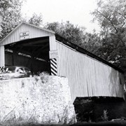
Print, Photographic
https://collections.lancasterhistory.org/en/permalink/b9948b29-6cca-41ad-9dee-433868174962
Collection
General Collection
Object ID
1-09-05-34
Date Range
c. 1960
More detail
1 image
Object Name
Print, Photographic
Collection
General Collection
Description
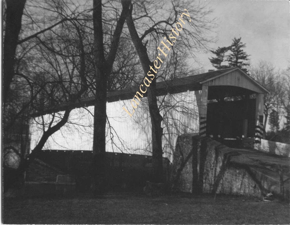
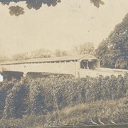
Poole Forge Bridge, west of Churchtown in Caernarvon Township on starting branch if Conestoga Creek. 99 feet long, built 1859.
Provenance
digital image only - original owned by Milton Haldeman
Date Range
c. 1960
Storage Location
LancasterHistory, Lancaster, PA
Subcategory
Documentary Artifact
Search Terms
Poole Forge
Churchtown, Caernarvon Twp.
Conestoga Creek
Covered bridges
Place
Caernarvon Twp.
Object Name
Print, Photographic
Condition
Good
Object ID
1-09-05-34
Images
Less detail
More Like This
Permalink
Toggle Full Record
Print, Photographic
https://collections.lancasterhistory.org/en/permalink/9ed35f2b-dd2f-495d-a730-130851132780
Collection
General Collection
Object ID
1-09-05-35
Date Range
c. 1960
More detail
1 image
Object Name
Print, Photographic
Collection
General Collection
Description
Isaac Shearer's Mill bridge, one mile north of Goodville in Caernarvon Township on starting branch of the Conestoga Creek. 8 feet long, built in 1878.
Provenance
digital image only - original owned by Milton Haldeman
Date Range
c. 1960
Storage Location
LancasterHistory, Lancaster, PA
People
Shearer, Isaac
Subcategory
Documentary Artifact
Search Terms
Shearer's Mill
Goodville, East Earl Twp.
Conestoga Creek
Covered bridges
Place
Caernarvon Twp.
Object Name
Print, Photographic
Condition
Good
Object ID
1-09-05-35
Images
Less detail
More Like This
Permalink
Toggle Full Record
Print, Photographic
https://collections.lancasterhistory.org/en/permalink/19f8bdb9-8c71-4508-b70a-045091169220
Collection
General Collection
Object ID
1-09-05-36
Date Range
c. 1960
More detail
1 image
Object Name
Print, Photographic
Collection
General Collection
Description
Israel Sensenig Mill bridge, Earl Township, on Conestoga Creek. 65 feet long, built in 1857.
Provenance
digital image only - original owned by Milton Haldeman
Date Range
c. 1960
Storage Location
LancasterHistory, Lancaster, PA
People
Sensenig, Israel
Subcategory
Documentary Artifact
Search Terms
Sensenig's Mill
Conestoga Creek
Covered bridges
Place
Earl Twp.
Object Name
Print, Photographic
Condition
Good
Object ID
1-09-05-36
Images
Less detail
More Like This
Permalink
Toggle Full Record
Print, Photographic
https://collections.lancasterhistory.org/en/permalink/7ff0429e-dc1d-4b80-a3ef-620706981930
Collection
General Collection
Object ID
1-09-05-37
More detail
1 image
Object Name
Print, Photographic
Collection
General Collection
Description
Isaac Bear's Mill bridge one mile south west of Martindale Road in Earl Township on the Conestoga Creek. 94 feet long, built in 1876.
Provenance
digital image only - original owned by Milton Haldeman
Storage Location
LancasterHistory, Lancaster, PA
People
Bear, Isaac
Subcategory
Documentary Artifact
Search Terms
Bear's Mill
Martindale, Earl Twp.
Conestoga Creek
Covered bridges
Place
Earl Twp.
Object Name
Print, Photographic
Condition
Good
Object ID
1-09-05-37
Images
Less detail
More Like This
Permalink
Toggle Full Record
Print, Photographic
https://collections.lancasterhistory.org/en/permalink/4fb6997a-8aeb-4f9a-a0a4-941735144483
Collection
General Collection
Object ID
1-09-05-38
More detail
1 image
Object Name
Print, Photographic
Collection
General Collection
Description
Martin's Mill bridge, two miles south of Murrell in Ephrata Township on Conestoga Creek. 98 1/2 feet long, built in 1846.
Provenance
digital image only - original owned by Milton Haldeman
Storage Location
LancasterHistory, Lancaster, PA
Subcategory
Documentary Artifact
Search Terms
Murrell, Ephrata Twp.
Covered bridges
Conestoga Creek
Place
Ephrata Twp.
Object Name
Print, Photographic
Condition
Good
Object ID
1-09-05-38
Images
Less detail
More Like This
Permalink
Toggle Full Record
Print, Photographic
https://collections.lancasterhistory.org/en/permalink/5e11b950-1583-44e7-b938-964597835030
Collection
General Collection
Object ID
1-09-05-39
More detail
1 image
Object Name
Print, Photographic
Collection
General Collection
Description
Nolt's Point Mill bridge near William Shand residence in Upper Leacock Township on Conestoga Creek. 133 feet long, built in 1867.
Provenance
digital image only - original owned by Milton Haldeman
Storage Location
LancasterHistory, Lancaster, PA
People
Shand, William
Subcategory
Documentary Artifact
Search Terms
Nolt's Mill
Pinetown, Upper Leacock Twp.
Conestoga Creek
Covered bridges
Place
Manheim Twp.
Object Name
Print, Photographic
Condition
Good
Object ID
1-09-05-39
Images
Less detail
More Like This
Permalink
Toggle Full Record
Print, Photographic
https://collections.lancasterhistory.org/en/permalink/36f685eb-9b13-4c0d-869a-529632006220
Collection
General Collection
Object ID
1-09-05-40
More detail
1 image
Object Name
Print, Photographic
Collection
General Collection
Description
Hunsecker's Mill between Manheim and Upper Leacock Townships on Conestoga Creek. 180 feet long, built in 1848.
Provenance
digital image only - original owned by Milton Haldeman
Storage Location
LancasterHistory, Lancaster, PA
Subcategory
Documentary Artifact
Search Terms
Hunsecker's Mill
Manheim Twp.
Upper Leacock Twp.
Conestoga Creek
Covered bridges
Object Name
Print, Photographic
Condition
Good
Object ID
1-09-05-40
Images
Less detail
More Like This
Permalink
20 records – page 1 of 1.
Prev
Next