It appears no script is enabled within your browser. Please enable JavaScript to use this site.
Skip header and navigation
Toggle navigation
Collections
Search
Help
Privacy
Your Selections:
0
Items
Staff Login
Revise Search
Revise Search
Revise search
Search
Data Source
Archives
595
Photographs
×
Data Source
All
A
B
C
D
E
F
G
H
I
J
K
L
M
N
O
P
Q
R
S
T
U
V
W
X
Y
Z
Sort
By Count
Alphabetical
Filtered by
Filter
Loading...
Collection
General Collection
244
Discover Lancaster Photograph Collection
17
Henry Kauffman Photograph Collection
6
Mills Album
5
Nathan Reist Glass Plate Collection
4
Churches Album
3
Barton Mill Photograph Collection
2
Lancaster 250 Collection
2
Covered Bridge Album
1
Ed Schopf Safe Harbor Collection
1
Leon Landis Album 6
1
×
Collection
All
A
B
C
D
E
F
G
H
I
J
K
L
M
N
O
P
Q
R
S
T
U
V
W
X
Y
Z
Sort
By Count
Alphabetical
Filtered by
Filter
Loading...
Subject
Abbeville, Lancaster Twp.
220
Houses
107
Mansions
107
Documentary Artifact
51
Mount Hope, Rapho Twp.
36
Fireplaces
24
Pennsylvania Renaissance Faire
16
Bedrooms
12
Dining rooms
11
Sporting Hill, Rapho Twp.
11
Furniture
9
Covered bridges
7
More
×
Subject
All
A
B
C
D
E
F
G
H
I
J
K
L
M
N
O
P
Q
R
S
T
U
V
W
X
Y
Z
Sort
By Count
Alphabetical
Filtered by
Filter
Loading...
Name
Lancaster Newspapers, Inc.
20
Heiges, George L.
13
Fritz, John Abram
6
Krone, Herbert Brickley
6
Reist, Nathan E.
4
Rineer, Amos Hunter Jr.
3
Barton, R. Harold
2
Zecher, Barry L.
2
Dering, Henry
1
Einolf, Albert L.
1
Erisman, George F. K.
1
Gleim, John S.
1
More
×
Name
All
A
B
C
D
E
F
G
H
I
J
K
L
M
N
O
P
Q
R
S
T
U
V
W
X
Y
Z
Sort
By Count
Alphabetical
Filtered by
Filter
Loading...
Place
Lancaster
505
East Hempfield Twp.
358
Lancaster Twp.
Manheim Twp.
101
Conestoga Twp.
96
Leacock Twp.
85
West Cocalico Twp.
75
Martic Twp.
69
Elizabeth Twp.
58
Rapho Twp.
East Lampeter Twp.
55
Paradise Twp.
53
More
×
Place
All
A
B
C
D
E
F
G
H
I
J
K
L
M
N
O
P
Q
R
S
T
U
V
W
X
Y
Z
Sort
By Count
Alphabetical
Filtered by
Filter
Loading...
Decade
1910s
7
1920s
11
1930s
1
1940s
1
1950s
12
1970s
99
1990s
73
×
Decade
All
A
B
C
D
E
F
G
H
I
J
K
L
M
N
O
P
Q
R
S
T
U
V
W
X
Y
Z
Sort
By Count
Alphabetical
Filtered by
Filter
Loading...
Material
Negative
171
Print, Photographic
84
Transparency, Slide
17
Slide
8
Negative, Glass Plate
6
×
Material
All
A
B
C
D
E
F
G
H
I
J
K
L
M
N
O
P
Q
R
S
T
U
V
W
X
Y
Z
Sort
By Count
Alphabetical
Filtered by
Filter
Loading...
Online Media
Image
286
×
Online Media
All
A
B
C
D
E
F
G
H
I
J
K
L
M
N
O
P
Q
R
S
T
U
V
W
X
Y
Z
Sort
By Count
Alphabetical
Filtered by
Filter
Loading...
Advanced Search
Help
more like: 7F8B5274-7D88-4EA1-A6BA-235477428052
Rapho Twp.
Lancaster Twp.
Photographs
Sorted by
Relevance
Sort by Title
Expand All
Collapse All
List View
Gallery View
Print
10 records – page 1 of 1.
Prev
Next
Toggle Full Record
Print, Photographic
https://collections.lancasterhistory.org/en/permalink/64e5a218-ad26-4f0c-9fa8-397208032800
Collection
Leon Landis Album 6
Object ID
A-06-01-09
More detail
1 image
Object Name
Print, Photographic
Collection
Leon Landis Album 6
Description
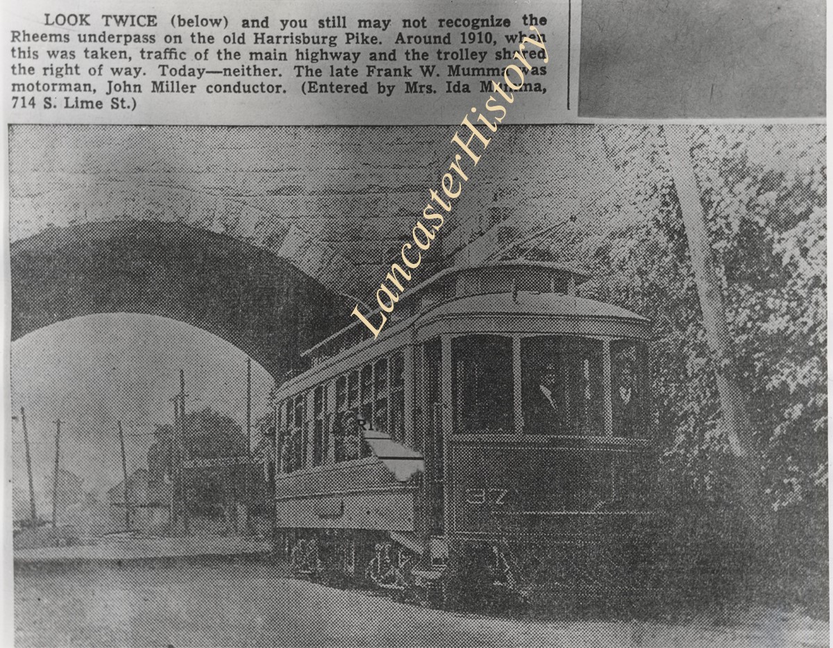
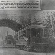
Newspaper photograph of the Rheems underpass on the old Harrisburg Pike. In 1910, when this was taken, traffic of the main highway and the trolley shared the right of way. Frank W. Mumma was motorman and John Miller was conductor.
Storage Location
LancasterHistory, Lancaster, PA
People
Mumma, Frank W.
Miller, John
Subcategory
Documentary Artifact
Search Terms
Trolleys
Highways
Bridges
Rheems, West Donegal Twp.
Place
Rapho Twp.
Object Name
Print, Photographic
Print Size
8 x 10 inches
Object ID
A-06-01-09
Images
Less detail
More Like This
Permalink
Toggle Full Record
Print, Photographic
https://collections.lancasterhistory.org/en/permalink/e4a4ca70-3d40-4374-86c8-557221343735
Collection
General Collection
Object ID
1-09-07-31
Date Range
c. 1930
More detail
1 image
Object Name
Print, Photographic
Collection
General Collection
Description
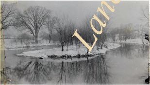
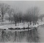
Little Conestoga Creek at Columbia Pike above West End Park about 1930, now Maple Grove Park. At that time there was an island above the dam.
Date Range
c. 1930
Creator
Einolf, Albert L.
Storage Location
LancasterHistory, Lancaster, PA
Subcategory
Documentary Artifact
Search Terms
Little Conestoga Creek
Columbia Pike
West End Park
Maple Grove
Islands
Place
Lancaster Twp.
Object Name
Print, Photographic
Print Size
2.75 x 4.5 inches
Object ID
1-09-07-31
Images
Less detail
More Like This
Permalink
Toggle Full Record
Print, Photographic
https://collections.lancasterhistory.org/en/permalink/304cc0f5-02ce-4c10-8198-756258749128
Collection
General Collection
Title
Photograph- Siegrist's Mill covered bridge across the Big Chiques Creek, southeast of Newtown.
Object ID
1-09-03-39
Date Range
June 1956
More detail
1 image
Object Name
Print, Photographic
Collection
General Collection
Title
Photograph- Siegrist's Mill covered bridge across the Big Chiques Creek, southeast of Newtown.
Description
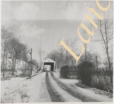
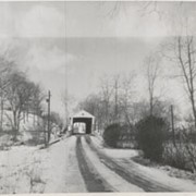
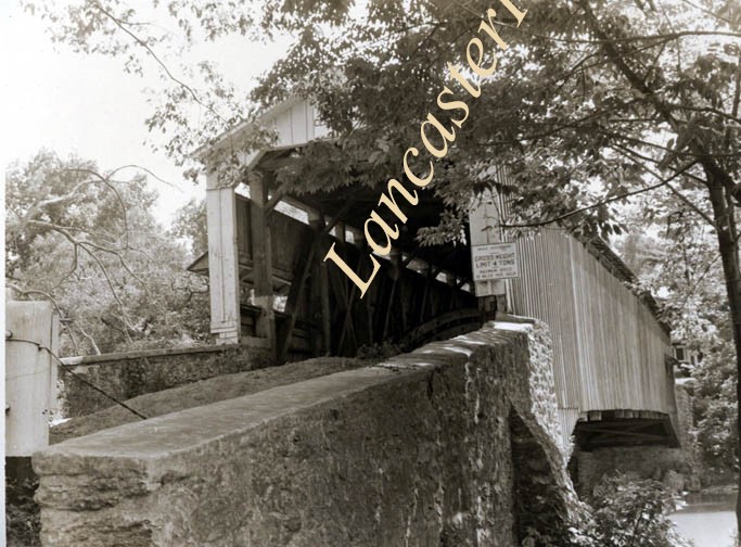
Siegrist's Mill covered bridge across the Big Chiques Creek, southeast of Newtown.
Provenance
Lancaster County covered bridge photos taken by M. E. Schroll and Kathryn L. Sauder taken between 1956 and 1958.
Date Range
June 1956
Storage Location
LancasterHistory, Lancaster, PA
Subcategory
Documentary Artifact
Search Terms
Siegrist's Mill
Covered bridges
Chiques Creek
Newtown, Rapho Twp.
Rapho Twp.
Chickies Creek
Place
Rapho Twp.
Object Name
Print, Photographic
Print Size
3.5 x 3.5 inches
Condition
Good
Object ID
1-09-03-39
Images
Less detail
More Like This
Permalink
Toggle Full Record
Print, Photographic
https://collections.lancasterhistory.org/en/permalink/d7425eea-1845-40f3-be2a-809844228659
Collection
General Collection
Title
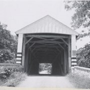
Photograph- Siegrist's Mill covered bridge across the Big Chiques Creek near Newtown.
Object ID
1-09-03-40
Date Range
February 9, 1958
More detail
1 image
Object Name
Print, Photographic
Collection
General Collection
Title
Photograph- Siegrist's Mill covered bridge across the Big Chiques Creek near Newtown.
Description
Siegrist's Mill covered bridge across the Big Chiques Creek near Newtown.
Provenance
Lancaster County covered bridge photos taken by M. E. Schroll and Kathryn L. Sauder taken between 1956 and 1958.
Date Range
February 9, 1958
Storage Location
LancasterHistory, Lancaster, PA
Subcategory
Documentary Artifact
Search Terms
Siegrist's Mill
Covered bridges
Chiques Creek
Newtown, Rapho Twp.
Rapho Twp.
Chickies Creek
Place
Rapho Twp.
Object Name
Print, Photographic
Print Size
3.5 x 3.5 inches
Condition
Good
Object ID
1-09-03-40
Images
Less detail
More Like This
Permalink
Toggle Full Record
Print, Photographic
https://collections.lancasterhistory.org/en/permalink/5810fd5d-3365-4917-a110-155675326037
Collection
General Collection
Object ID
1-09-05-41
More detail
1 image
Object Name
Print, Photographic
Collection
General Collection
Description
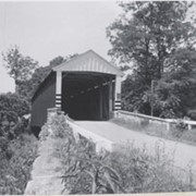
Israel Groff's Factory bridge at water's edge in Lancaster Township, a half mile south of Eden on the Conestoga River. 158 feet long, built in 1848.
Provenance
digital image only - original owned by Milton Haldeman
Storage Location
LancasterHistory, Lancaster, PA
Subcategory
Documentary Artifact
Search Terms
Groff Factory Bridge
Lancaster Twp.
Conestoga River
Covered bridges
Place
Lancaster Twp.
Object Name
Print, Photographic
Condition
Good
Object ID
1-09-05-41
Images
Less detail
More Like This
Permalink
Toggle Full Record
Print, Photographic
https://collections.lancasterhistory.org/en/permalink/ac7b4f34-8612-46a0-9a19-171450654357
Collection
General Collection
Title
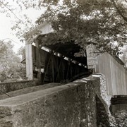
Photograph- Siegrist's Mill covered bridge on the Big Chiques Creek southeast of Newtown.
Object ID
1-09-03-38
Date Range
June 1956
More detail
1 image
Object Name
Print, Photographic
Collection
General Collection
Title
Photograph- Siegrist's Mill covered bridge on the Big Chiques Creek southeast of Newtown.
Description
Siegrist's Mill covered bridge on the Big Chiques Creek southeast of Newtown.
Provenance
Lancaster County covered bridge photos taken by M. E. Schroll and Kathryn L. Sauder taken between 1956 and 1958.
Date Range
June 1956
Storage Location
LancasterHistory, Lancaster, PA
Subcategory
Documentary Artifact
Search Terms
Siegrist's Mill
Covered bridges
Chiques Creek
Newtown, Rapho Twp.
Chickies Creek
Place
Rapho Twp.
Object Name
Print, Photographic
Print Size
3.5 x 3.5 inches
Condition
Good
Object ID
1-09-03-38
Images
Less detail
More Like This
Permalink
Toggle Full Record
Print, Photographic
https://collections.lancasterhistory.org/en/permalink/98e85d2f-ebba-4ccb-b24e-105088932230
Collection
General Collection
Title
Photograph- Gibble Graveyard, northwest of Chiques Road.
Object ID
1-06-03-67
More detail
1 image
Object Name
Print, Photographic
Collection
General Collection
Title
Photograph- Gibble Graveyard, northwest of Chiques Road.
Description
Gibble Graveyard, northwest of Chiques Road.
Creator
Heiges, George L.
Storage Location
LancasterHistory, Lancaster, PA
Subcategory
Documentary Artifact
Search Terms
Graveyards
Cemeteries
Gibble Graveyard
Rapho Twp.
Place
Rapho Twp.
Object Name
Print, Photographic
Print Size
3.25 x 5.875 inches
Condition
Good
Condition Date
edges torn
Object ID
1-06-03-67
Images
Less detail
More Like This
Permalink
Toggle Full Record
Negative, Glass Plate
https://collections.lancasterhistory.org/en/permalink/b3d08d60-997e-489f-939b-168167553760
Collection
Nathan Reist Glass Plate Collection
Object ID
NR-01-01-55
Date Range
c. 1910
More detail
1 image
Object Name
Negative, Glass Plate
Collection
Nathan Reist Glass Plate Collection
Description
"Big dead tree north of Mt. Hope"
Provenance
Nathan Reist was a teacher and amateur photographer who lived and taught in Warwick Township and Lititz.
Date Range
c. 1910
Creator
Reist, Nathan E.
Storage Location
LancasterHistory, Lancaster, PA
Subcategory
Documentary Artifact
Search Terms
Trees
Mount Hope, Rapho Twp.
Place
Rapho Twp.
Object Name
Negative, Glass Plate
Film Size
4 x 5 inches
Object ID
NR-01-01-55
Images
Less detail
More Like This
Permalink
Toggle Full Record
Negative, Glass Plate
https://collections.lancasterhistory.org/en/permalink/9f0a4022-267c-4391-a6c3-572584920636
Collection
Nathan Reist Glass Plate Collection
Object ID
NR-02-01-69
Date Range
c. 1910
More detail
1 image
Object Name
Negative, Glass Plate
Collection
Nathan Reist Glass Plate Collection
Description
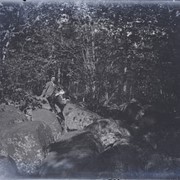
"Earl & Jas. on the rocks, Mt. Hope"
Provenance
Nathan Reist was a teacher and amateur photographer who lived and taught in Warwick Township and Lititz.
Date Range
c. 1910
Creator
Reist, Nathan E.
Storage Location
LancasterHistory, Lancaster, PA
Subcategory
Documentary Artifact
Search Terms
Woods
Mount Hope, Rapho Twp.
Place
Rapho Twp.
Object Name
Negative, Glass Plate
Film Size
4 x 5 inches
Object ID
NR-02-01-69
Images
Less detail
More Like This
Permalink
Toggle Full Record
Negative, Glass Plate
https://collections.lancasterhistory.org/en/permalink/cda719b0-edb7-4772-8f57-434195083669
Collection
Nathan Reist Glass Plate Collection
Object ID
NR-03-01-34
Date Range
1911
More detail
1 image
Object Name
Negative, Glass Plate
Collection
Nathan Reist Glass Plate Collection
Description
"Sporting Hill dam, view No. 2"
Provenance
Nathan Reist was a teacher and amateur photographer who lived and taught in Warwick Township and Lititz.
Date Range
1911
Creator
Reist, Nathan E.
Storage Location
LancasterHistory, Lancaster, PA
Subcategory
Documentary Artifact
Search Terms
Sporting Hill, Rapho Twp.
Creeks
Dams
Place
Rapho Twp.
Object Name
Negative, Glass Plate
Film Size
4 x 5 inches
Object ID
NR-03-01-34
Images
Less detail
More Like This
Permalink
10 records – page 1 of 1.
Prev
Next