It appears no script is enabled within your browser. Please enable JavaScript to use this site.
Skip header and navigation
Toggle navigation
Collections
Search
Help
Privacy
Your Selections:
0
Items
Staff Login
Revise Search
Revise Search
Revise search
Search
Data Source
Archives
2194
Photographs
×
Data Source
All
A
B
C
D
E
F
G
H
I
J
K
L
M
N
O
P
Q
R
S
T
U
V
W
X
Y
Z
Sort
By Count
Alphabetical
Filtered by
Filter
Loading...
Collection
General Collection
40
Gerald High Schoolhouse Photo Album
15
Kelly Williams Schoolhouse Photo Album
12
Barton Mill Photograph Collection
9
Churches Album
9
Postcard Collection
4
Earl Rebman Photograph Collection
3
Covered Bridge Safari Album
2
Discover Lancaster Photograph Collection
2
Mills Album
1
×
Collection
All
A
B
C
D
E
F
G
H
I
J
K
L
M
N
O
P
Q
R
S
T
U
V
W
X
Y
Z
Sort
By Count
Alphabetical
Filtered by
Filter
Loading...
Subject
Documentary Artifact
73
Schoolhouses
29
Covered bridges
23
Conestoga River
14
Hinkletown, Earl Twp.
14
Martindale, Earl Twp.
13
Religion
9
Voganville, Earl Twp.
8
Bridges
7
Hinkletown Mill
7
Conestoga Creek
6
Kurtz's Mill Covered Bridge
6
More
×
Subject
All
A
B
C
D
E
F
G
H
I
J
K
L
M
N
O
P
Q
R
S
T
U
V
W
X
Y
Z
Sort
By Count
Alphabetical
Filtered by
Filter
Loading...
Name
Williams, Kelly
12
Rineer, Amos Hunter Jr.
9
Barton, R. Harold
5
Kurtz, Howard G. Sr.
3
Vogan, John
3
Bixler, Robert Theodore
2
Ammon, Mary
1
Ammon, Wayne
1
Baum, Keith
1
Beam, Lizzie
1
Bear, Isaac
1
Bond, G. Ross
1
More
×
Name
All
A
B
C
D
E
F
G
H
I
J
K
L
M
N
O
P
Q
R
S
T
U
V
W
X
Y
Z
Sort
By Count
Alphabetical
Filtered by
Filter
Loading...
Place
Lancaster
18866
Lancaster Twp.
1106
Manheim Twp.
804
East Hempfield Twp.
749
Conestoga Twp.
706
Salisbury Twp.
706
Columbia
619
Ephrata
519
Martic Twp.
385
West Lampeter Twp.
382
Manheim
365
Marietta
356
More
×
Place
All
A
B
C
D
E
F
G
H
I
J
K
L
M
N
O
P
Q
R
S
T
U
V
W
X
Y
Z
Sort
By Count
Alphabetical
Filtered by
Filter
Loading...
Decade
1890s
1
1900s
1
1920s
9
1930s
4
1950s
4
1960s
5
1970s
5
1990s
34
2000s
3
×
Decade
All
A
B
C
D
E
F
G
H
I
J
K
L
M
N
O
P
Q
R
S
T
U
V
W
X
Y
Z
Sort
By Count
Alphabetical
Filtered by
Filter
Loading...
Material
Print, Photographic
86
Negative
4
Postcard
4
Negative, Glass Plate
2
Transparency, Slide
1
×
Material
All
A
B
C
D
E
F
G
H
I
J
K
L
M
N
O
P
Q
R
S
T
U
V
W
X
Y
Z
Sort
By Count
Alphabetical
Filtered by
Filter
Loading...
Online Media
Image
97
×
Online Media
All
A
B
C
D
E
F
G
H
I
J
K
L
M
N
O
P
Q
R
S
T
U
V
W
X
Y
Z
Sort
By Count
Alphabetical
Filtered by
Filter
Loading...
Advanced Search
Help
more like: 8B5399F6-8CFC-4CEE-B175-721435578605
Conestoga Twp. and Martic Twp.
Earl Twp.
Photographs
Sorted by
Relevance
Sort by Title
Expand All
Collapse All
List View
Gallery View
Print
10 records – page 1 of 1.
Prev
Next
Toggle Full Record
Print, Photographic
https://collections.lancasterhistory.org/en/permalink/7ff0429e-dc1d-4b80-a3ef-620706981930
Collection
General Collection
Object ID
1-09-05-37
More detail
1 image
Object Name
Print, Photographic
Collection
General Collection
Description
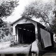
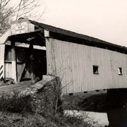
Isaac Bear's Mill bridge one mile south west of Martindale Road in Earl Township on the Conestoga Creek. 94 feet long, built in 1876.
Provenance
digital image only - original owned by Milton Haldeman
Storage Location
LancasterHistory, Lancaster, PA
People
Bear, Isaac
Subcategory
Documentary Artifact
Search Terms
Bear's Mill
Martindale, Earl Twp.
Conestoga Creek
Covered bridges
Place
Earl Twp.
Object Name
Print, Photographic
Condition
Good
Object ID
1-09-05-37
Images
Less detail
More Like This
Permalink
Toggle Full Record
Print, Photographic
https://collections.lancasterhistory.org/en/permalink/9883b8ab-ee74-4cf1-b354-971200293520
Collection
General Collection
Title
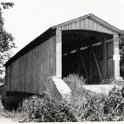
Photograph- Covered bridge southwest of Martindale over the Conestoga Creek. Built in 1853.
Object ID
1-01-04-85
More detail
1 image
Object Name
Print, Photographic
Collection
General Collection
Title
Photograph- Covered bridge southwest of Martindale over the Conestoga Creek. Built in 1853.
Description
Covered bridge southwest of Martindale over the Conestoga Creek. Built in 1853.
Storage Location
LancasterHistory, Lancaster, PA
Subcategory
Documentary Artifact
Search Terms
Covered bridges
Conestoga Creek
Martindale, Earl Twp.
Place
Earl Twp.
Object Name
Print, Photographic
Print Size
5 x 4 inches
Object ID
1-01-04-85
Images
Less detail
More Like This
Permalink
Toggle Full Record
Print, Photographic
https://collections.lancasterhistory.org/en/permalink/0cdafcd0-3c90-4030-b57e-664763181032
Collection
General Collection
Title
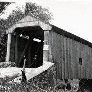
Photograph- Covered bridge near Martindale over the Conestoga Creek. Built in 1861.
Object ID
1-01-04-86
More detail
1 image
Object Name
Print, Photographic
Collection
General Collection
Title
Photograph- Covered bridge near Martindale over the Conestoga Creek. Built in 1861.
Description
Covered bridge near Martindale over the Conestoga Creek. Built in 1861.
Storage Location
LancasterHistory, Lancaster, PA
Subcategory
Documentary Artifact
Search Terms
Covered bridges
Conestoga Creek
Martindale, Earl Twp.
Place
Earl Twp.
Object Name
Print, Photographic
Print Size
5 x 4 inches
Object ID
1-01-04-86
Images
Less detail
More Like This
Permalink
Toggle Full Record
Negative, Glass Plate
https://collections.lancasterhistory.org/en/permalink/bdcebde1-46e9-4736-929e-958437508235
Collection
General Collection
Object ID
1-16-01-17
More detail
1 image
Object Name
Negative, Glass Plate
Collection
General Collection
Description
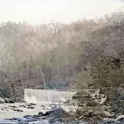
Dam on a small creek in the woods, thought to be on the Pequea Creek downstream from the Colemanvill Covered Bridge.
Provenance
Gift of Mrs. Leo Ruof, January 18, 1956.
Storage Location
LancasterHistory, Lancaster, PA
Subcategory
Documentary Artifact
Subject
Photographs
Classification
1-16-01-17
Search Terms
Dams
Creeks
Woods
Pequea Creek
Place
Conestoga Twp. and Martic Twp.
Object Name
Negative, Glass Plate
Print Size
5 x 7 inches
Condition
Good
Object ID
1-16-01-17
Images
Less detail
More Like This
Permalink
Toggle Full Record
Print, Photographic
https://collections.lancasterhistory.org/en/permalink/19f8bdb9-8c71-4508-b70a-045091169220
Collection
General Collection
Object ID
1-09-05-36
Date Range
c. 1960
More detail
1 image
Object Name
Print, Photographic
Collection
General Collection
Description
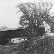
Israel Sensenig Mill bridge, Earl Township, on Conestoga Creek. 65 feet long, built in 1857.
Provenance
digital image only - original owned by Milton Haldeman
Date Range
c. 1960
Storage Location
LancasterHistory, Lancaster, PA
People
Sensenig, Israel
Subcategory
Documentary Artifact
Search Terms
Sensenig's Mill
Conestoga Creek
Covered bridges
Place
Earl Twp.
Object Name
Print, Photographic
Condition
Good
Object ID
1-09-05-36
Images
Less detail
More Like This
Permalink
Toggle Full Record
Print, Photographic
https://collections.lancasterhistory.org/en/permalink/42ea4193-7d7e-44fd-bf1b-122666449520
Collection
General Collection
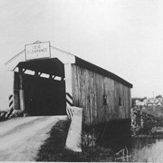
Title
Photograph- Martindale covered bridge over the Conestoga Creek. Built in 1861.
Object ID
1-01-04-84
More detail
1 image
Object Name
Print, Photographic
Collection
General Collection
Title
Photograph- Martindale covered bridge over the Conestoga Creek. Built in 1861.
Description
Martindale covered bridge over the Conestoga Creek. Built in 1861.
Storage Location
LancasterHistory, Lancaster, PA
Subcategory
Documentary Artifact
Search Terms
Covered bridges
Conestoga Creek
Place
Earl Twp.
Object Name
Print, Photographic
Print Size
5 x 4 inches
Object ID
1-01-04-84
Images
Less detail
More Like This
Permalink
Toggle Full Record
Print, Photographic
https://collections.lancasterhistory.org/en/permalink/166be8ad-9749-49c0-9dd1-421797280040
Collection
General Collection
Object ID
2-04-06-08
More detail
1 image
Object Name
Print, Photographic
Collection
General Collection
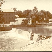
Description
Dam at Hinkletown Mill, along route 322, south of Ephrata
Storage Location
LancasterHistory, Lancaster, PA
Subcategory
Documentary Artifact
Search Terms
Hinkletown Mill
Hinkletown, Earl Twp.
Conestoga Creek
Dams
Place
Earl Twp.
Object Name
Print, Photographic
Print Size
6.5 x 5.5 inches
Object ID
2-04-06-08
Images
Less detail
More Like This
Permalink
Toggle Full Record
Print, Photographic
https://collections.lancasterhistory.org/en/permalink/fd31f801-338a-4091-a7b9-401946346360
Collection
General Collection
Title
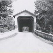
Photograph- End view of Kurtz's Mill covered bridge across Big Conestoga, north of Fairmount.
Object ID
1-09-03-34
Date Range
August 1956
More detail
1 image
Object Name
Print, Photographic
Collection
General Collection
Title
Photograph- End view of Kurtz's Mill covered bridge across Big Conestoga, north of Fairmount.
Description
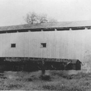
End view of Kurtz's Mill covered bridge across Big Conestoga.
Provenance
Lancaster County covered bridge photos taken by M. E. Schroll and Kathryn L. Sauder taken between 1956 and 1958.
Date Range
August 1956
Storage Location
LancasterHistory, Lancaster, PA
Subcategory
Documentary Artifact
Search Terms
Covered bridges
Conestoga River
Kurtz's Mill Covered Bridge
Martindale, Earl Twp.
Place
Earl Twp.
Object Name
Print, Photographic
Print Size
3.5 x 3.5 inches
Condition
Good
Object ID
1-09-03-34
Images
Less detail
More Like This
Permalink
Toggle Full Record
Print, Photographic
https://collections.lancasterhistory.org/en/permalink/b1553a20-35f9-4bae-9bd2-504284932800
Collection
General Collection
Object ID
1-20-04-57
More detail
1 image
Object Name
Print, Photographic
Collection
General Collection
Description
Covered bridge. Bridge number 6 over the Conestoga River, possibly on White Oak Road near Martindale.
Provenance
Photographs taken by Lancaster County during bridge repair work. Gift of Gordon Reed.
Year Range From
1920
Year Range To
1929
Storage Location
LancasterHistory, Lancaster, PA
Search Terms
Covered bridges
Conestoga River
Martindale, Earl Twp.
Place
Earl Twp.
Object Name
Print, Photographic
Print Size
3.25 x 5.5 inches
Object ID
1-20-04-57
Images
Less detail
More Like This
Permalink
Toggle Full Record
Print, Photographic
https://collections.lancasterhistory.org/en/permalink/b1104576-702e-4b76-af5d-316152117390
Collection
General Collection
Object ID
1-20-04-58
More detail
1 image
Object Name
Print, Photographic
Collection
General Collection
Description
Covered bridge. Bridge number 7 over the Conestoga River, possibly on Gristmill Road near Martindale.
Provenance
Photographs taken by Lancaster County during bridge repair work. Gift of Gordon Reed.
Year Range From
1920
Year Range To
1929
Storage Location
LancasterHistory, Lancaster, PA
Search Terms
Covered bridges
Conestoga River
Martindale, Earl Twp.
Place
Earl Twp.
Object Name
Print, Photographic
Print Size
3.25 x 5.5 inches
Object ID
1-20-04-58
Images
Less detail
More Like This
Permalink
10 records – page 1 of 1.
Prev
Next