It appears no script is enabled within your browser. Please enable JavaScript to use this site.
Skip header and navigation
Toggle navigation
Collections
Search
Help
Privacy
Your Selections:
0
Items
Staff Login
Revise Search
Revise Search
Revise search
Search
Data Source
Photographs
25
Archives
4
×
Data Source
All
A
B
C
D
E
F
G
H
I
J
K
L
M
N
O
P
Q
R
S
T
U
V
W
X
Y
Z
Sort
By Count
Alphabetical
Filtered by
Filter
Loading...
Collection
Administrators Accounts
1262
Commissioners' Orders for Payment
203
Liquor License Papers
183
Renunciations
121
Estate Inventories
68
Collateral Appraisements
46
Quarter Sessions
40
Marriage Applications and Consent Forms
29
General Collection
Indictments
22
Bridge Records
20
Gerald High Schoolhouse Photo Album
15
More
×
Collection
All
A
B
C
D
E
F
G
H
I
J
K
L
M
N
O
P
Q
R
S
T
U
V
W
X
Y
Z
Sort
By Count
Alphabetical
Filtered by
Filter
Loading...
Subject
Documentary Artifact
Covered bridges
19
Conestoga River
13
Ellmaker homestead
13
Martindale, Earl Twp.
9
Cemeteries
7
Conestoga Creek
Graveyards
6
Kurtz's Mill Covered Bridge
6
Voganville, Earl Twp.
6
Earl Twp.
4
Vouchers
4
More
×
Subject
All
A
B
C
D
E
F
G
H
I
J
K
L
M
N
O
P
Q
R
S
T
U
V
W
X
Y
Z
Sort
By Count
Alphabetical
Filtered by
Filter
Loading...
Name
Orphans' Court
4
Vogan, John
3
Bixler, Robert Theodore
2
Bear, Isaac
1
Cacka, David B.
1
Graybill, Isaac
1
Grim, John
1
Korrell, Sarah
1
Ream, William W.
1
Sensenig, Aaron
1
Sensenig, Israel
1
Sensenig, Mary
1
More
×
Name
All
A
B
C
D
E
F
G
H
I
J
K
L
M
N
O
P
Q
R
S
T
U
V
W
X
Y
Z
Sort
By Count
Alphabetical
Filtered by
Filter
Loading...
Place
Lancaster
5141
Manheim Twp.
297
Manheim
233
none
208
Martic Twp.
207
Conestoga Twp.
147
Manor Twp.
145
Lancaster Twp.
135
Columbia
132
East Donegal Twp.
126
Ephrata
112
West Lampeter Twp.
112
More
×
Place
All
A
B
C
D
E
F
G
H
I
J
K
L
M
N
O
P
Q
R
S
T
U
V
W
X
Y
Z
Sort
By Count
Alphabetical
Filtered by
Filter
Loading...
Decade
1820s
1
1830s
1
1840s
1
1850s
1
1920s
1
1930s
1
1950s
3
1960s
3
1970s
1
1990s
7
2000s
1
×
Decade
All
A
B
C
D
E
F
G
H
I
J
K
L
M
N
O
P
Q
R
S
T
U
V
W
X
Y
Z
Sort
By Count
Alphabetical
Filtered by
Filter
Loading...
Material
Print, Photographic
24
Voucher
4
Negative, Glass Plate
1
×
Material
All
A
B
C
D
E
F
G
H
I
J
K
L
M
N
O
P
Q
R
S
T
U
V
W
X
Y
Z
Sort
By Count
Alphabetical
Filtered by
Filter
Loading...
Archival Hierarchy
Item
4
×
Archival Hierarchy
All
A
B
C
D
E
F
G
H
I
J
K
L
M
N
O
P
Q
R
S
T
U
V
W
X
Y
Z
Sort
By Count
Alphabetical
Filtered by
Filter
Loading...
Online Media
Image
25
×
Online Media
All
A
B
C
D
E
F
G
H
I
J
K
L
M
N
O
P
Q
R
S
T
U
V
W
X
Y
Z
Sort
By Count
Alphabetical
Filtered by
Filter
Loading...
Advanced Search
Help
more like: 8E35BF98-08E2-416C-8CAE-187699158633
Earl Twp.
Estate Vouchers
General Collection
Conestoga Creek
Documentary Artifact
Sorted by
Relevance
Sort by Title
Expand All
Collapse All
List View
Gallery View
Print
10 records – page 1 of 1.
Prev
Next
Toggle Full Record
Print, Photographic
https://collections.lancasterhistory.org/en/permalink/fd31f801-338a-4091-a7b9-401946346360
Collection
General Collection
Title
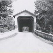
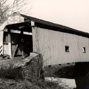
Photograph- End view of Kurtz's Mill covered bridge across Big Conestoga, north of Fairmount.
Object ID
1-09-03-34
Date Range
August 1956
More detail
1 image
Object Name
Print, Photographic
Collection
General Collection
Title
Photograph- End view of Kurtz's Mill covered bridge across Big Conestoga, north of Fairmount.
Description
End view of Kurtz's Mill covered bridge across Big Conestoga.
Provenance
Lancaster County covered bridge photos taken by M. E. Schroll and Kathryn L. Sauder taken between 1956 and 1958.
Date Range
August 1956
Storage Location
LancasterHistory, Lancaster, PA
Subcategory
Documentary Artifact
Search Terms
Covered bridges
Conestoga River
Kurtz's Mill Covered Bridge
Martindale, Earl Twp.
Place
Earl Twp.
Object Name
Print, Photographic
Print Size
3.5 x 3.5 inches
Condition
Good
Object ID
1-09-03-34
Images
Less detail
More Like This
Permalink
Toggle Full Record
Print, Photographic
https://collections.lancasterhistory.org/en/permalink/7ff0429e-dc1d-4b80-a3ef-620706981930
Collection
General Collection
Object ID
1-09-05-37
More detail
1 image
Object Name
Print, Photographic
Collection
General Collection
Description
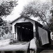
Isaac Bear's Mill bridge one mile south west of Martindale Road in Earl Township on the Conestoga Creek. 94 feet long, built in 1876.
Provenance
digital image only - original owned by Milton Haldeman
Storage Location
LancasterHistory, Lancaster, PA
People
Bear, Isaac
Subcategory
Documentary Artifact
Search Terms
Bear's Mill
Martindale, Earl Twp.
Conestoga Creek
Covered bridges
Place
Earl Twp.
Object Name
Print, Photographic
Condition
Good
Object ID
1-09-05-37
Images
Less detail
More Like This
Permalink
Toggle Full Record
Print, Photographic
https://collections.lancasterhistory.org/en/permalink/9883b8ab-ee74-4cf1-b354-971200293520
Collection
General Collection
Title
Photograph- Covered bridge southwest of Martindale over the Conestoga Creek. Built in 1853.
Object ID
1-01-04-85
More detail
1 image
Object Name
Print, Photographic
Collection
General Collection
Title
Photograph- Covered bridge southwest of Martindale over the Conestoga Creek. Built in 1853.
Description
Covered bridge southwest of Martindale over the Conestoga Creek. Built in 1853.
Storage Location
LancasterHistory, Lancaster, PA
Subcategory
Documentary Artifact
Search Terms
Covered bridges
Conestoga Creek
Martindale, Earl Twp.
Place
Earl Twp.
Object Name
Print, Photographic
Print Size
5 x 4 inches
Object ID
1-01-04-85
Images
Less detail
More Like This
Permalink
Toggle Full Record
Print, Photographic
https://collections.lancasterhistory.org/en/permalink/0cdafcd0-3c90-4030-b57e-664763181032
Collection
General Collection
Title
Photograph- Covered bridge near Martindale over the Conestoga Creek. Built in 1861.
Object ID
1-01-04-86
More detail
1 image
Object Name
Print, Photographic
Collection
General Collection
Title
Photograph- Covered bridge near Martindale over the Conestoga Creek. Built in 1861.
Description
Covered bridge near Martindale over the Conestoga Creek. Built in 1861.
Storage Location
LancasterHistory, Lancaster, PA
Subcategory
Documentary Artifact
Search Terms
Covered bridges
Conestoga Creek
Martindale, Earl Twp.
Place
Earl Twp.
Object Name
Print, Photographic
Print Size
5 x 4 inches
Object ID
1-01-04-86
Images
Less detail
More Like This
Permalink
Toggle Full Record
Print, Photographic
https://collections.lancasterhistory.org/en/permalink/19f8bdb9-8c71-4508-b70a-045091169220
Collection
General Collection
Object ID
1-09-05-36
Date Range
c. 1960
More detail
1 image
Object Name
Print, Photographic
Collection
General Collection
Description
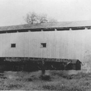
Israel Sensenig Mill bridge, Earl Township, on Conestoga Creek. 65 feet long, built in 1857.
Provenance
digital image only - original owned by Milton Haldeman
Date Range
c. 1960
Storage Location
LancasterHistory, Lancaster, PA
People
Sensenig, Israel
Subcategory
Documentary Artifact
Search Terms
Sensenig's Mill
Conestoga Creek
Covered bridges
Place
Earl Twp.
Object Name
Print, Photographic
Condition
Good
Object ID
1-09-05-36
Images
Less detail
More Like This
Permalink
Toggle Full Record
Print, Photographic
https://collections.lancasterhistory.org/en/permalink/7ee8a894-f2c8-40a8-a73d-184924791605
Collection
General Collection
Object ID
1-09-03-77
Date Range
August 1956
More detail
1 image
Object Name
Print, Photographic
Collection
General Collection
Description
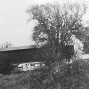
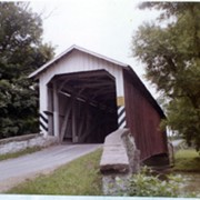
Kurtz's Mill covered bridge across the Conestoga River.
Provenance
Lancaster County covered bridge photos taken by M. E. Schroll and Kathryn L. Sauder taken between 1956 and 1958.
Date Range
August 1956
Storage Location
LancasterHistory, Lancaster, PA
Subcategory
Documentary Artifact
Search Terms
Kurtz's Mill Covered Bridge
Covered bridges
Conestoga River
Place
Earl Twp.
Object Name
Print, Photographic
Print Size
3.5 x 3.5 inches
Condition
Good
Object ID
1-09-03-77
Images
Less detail
More Like This
Permalink
Toggle Full Record
Print, Photographic
https://collections.lancasterhistory.org/en/permalink/dc74fc5a-3399-4e48-ace8-012576676623
Collection
General Collection
Object ID
1-09-03-78
Date Range
August 7, 1958
More detail
1 image
Object Name
Print, Photographic
Collection
General Collection
Description
Kurtz's Mill covered bridge on the Conestoga River.
Provenance
Lancaster County covered bridge photos taken by M. E. Schroll and Kathryn L. Sauder taken between 1956 and 1958.
Date Range
August 7, 1958
Storage Location
LancasterHistory, Lancaster, PA
Subcategory
Documentary Artifact
Search Terms
Kurtz's Mill Covered Bridge
Covered bridges
Conestoga River
Place
Earl Twp.
Object Name
Print, Photographic
Print Size
3.5 x 3.5 inches
Condition
Good
Object ID
1-09-03-78
Images
Less detail
More Like This
Permalink
Toggle Full Record
Print, Photographic
https://collections.lancasterhistory.org/en/permalink/6a4bef79-d9a3-4c41-affa-349331030335
Collection
General Collection
Object ID
2-12-02-27
Date Range
c. 1920
More detail
1 image
Object Name
Print, Photographic
Collection
General Collection
Description
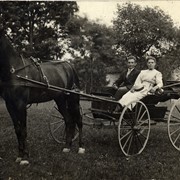
Mary and Aaron Sensenig on an outing in their horse and buggy near Martindale, PA.
Provenance
Original image owned by Karen Haldeman.
Date Range
c. 1920
Storage Location
LancasterHistory, Lancaster, PA
People
Sensenig, Mary
Sensenig, Aaron
Subcategory
Documentary Artifact
Search Terms
Picnics
Horses
Wagons
Martindale, Earl Twp.
Place
Earl Twp.
Object Name
Print, Photographic
Object ID
2-12-02-27
Notes
Donated for "Lancaster at Play" photograph book.
Images
Less detail
More Like This
Permalink
Toggle Full Record
Print, Photographic
https://collections.lancasterhistory.org/en/permalink/166be8ad-9749-49c0-9dd1-421797280040
Collection
General Collection
Object ID
2-04-06-08
More detail
1 image
Object Name
Print, Photographic
Collection
General Collection
Description
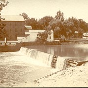
Dam at Hinkletown Mill, along route 322, south of Ephrata
Storage Location
LancasterHistory, Lancaster, PA
Subcategory
Documentary Artifact
Search Terms
Hinkletown Mill
Hinkletown, Earl Twp.
Conestoga Creek
Dams
Place
Earl Twp.
Object Name
Print, Photographic
Print Size
6.5 x 5.5 inches
Object ID
2-04-06-08
Images
Less detail
More Like This
Permalink
Toggle Full Record
Print, Photographic
https://collections.lancasterhistory.org/en/permalink/b8037eff-2d39-4ce1-aeb1-407618495169
Collection
General Collection
Object ID
1-10-03-62
Date Range
July 9, 2000
More detail
1 image
Object Name
Print, Photographic
Collection
General Collection
Description
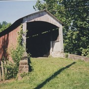
Old Red Run covered bridge near Gristmill Road between Red Run Road and Sensenig Road.
Date Range
July 9, 2000
Storage Location
LancasterHistory, Lancaster, PA
Subcategory
Documentary Artifact
Search Terms
Covered bridges
Red Run
Place
Earl Twp.
Object Name
Print, Photographic
Print Size
3.5 x 5 inches
Object ID
1-10-03-62
Images
Less detail
More Like This
Permalink
10 records – page 1 of 1.
Prev
Next