Skip header and navigation

Revise Search

10 records – page 1 of 1.

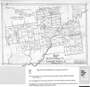
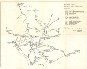
Map showing location and date of the earliest highways leading from the Delaware and Schulkill Rivers to the Susquehanna River and it's branches / by H. Frank Eshleman

https://collections.lancasterhistory.org/en/permalink/lhdo15534
Author
Eshleman, H. Frank
Date of Publication
1907.
Call Number
974.815 SEPA 100
  1 document  
Author
Eshleman, H. Frank
Place of Publication
Lancaster, Pa
Publisher
H. Frank Eshleman,
Date of Publication
1907.
Physical Description
1 map ; 22 x 41 cm.
Notes
Scale on map [ca. 1:418,176]. 3/4 in. = 5 mi.
May be a reduced reproduction of the original map.
Subjects
Roads - Pennsylvania - Lancaster County - Maps.
Roads - Pennsylvania - Chester County - Maps.
Roads - Pennsylvania - Delaware County - Maps.
Lancaster County (Pa.) - Maps.
Chester County (Pa.) - Maps.
Delaware County (Pa.) - Maps.
Location
Lancaster History Library - Map
Call Number
974.815 SEPA 100
Documents

map_974.815_SEPA_100_.pdf

Read PDF Download PDF
Less detail

Map of the first settlement of Lancaster County, Pa. October, 1710

https://collections.lancasterhistory.org/en/permalink/lhdo7490
Author
Eshleman, Henry Frank ,
Call Number
974.815 LACO 136
  1 document  
Responsibility
prepared by H. Frank Eshleman Chrmn., A. K. Hostetter, Chas. T. Steigerwalt, Committee of the Lancaster County Historical Society, Jan. 26, 1910.
Author
Eshleman, Henry Frank ,
Physical Description
1 map : photocopy ; 19 x 26 cm.
Notes
"The map numerously cut by lines, figures, roads and names represents the farms, their ownership and size, and the small properties the roads etc. occupying the original tract today V. 12 1910".
Originally published with: Eshleman, Henry Frank Report on the true character, time and place of the first regular settlement in Lancaster County, Lancaster, Pa.: Lancaster County Historical Society, 1910 Historical papers and addresses of the Lancaster County Historical Society, v. 14 no. 2.
Subjects
Land grants - Pennsylvania - Lancaster County
Real property - Pennsylvania - Lancaster County
Pequea Valley (Pa.)
Lancaster County (Pa.) - Maps.
Additional Author
Stagerwalt, Chas. T.
Hostetter, A.K.
Location
Lancaster History Library - Map
Call Number
974.815 LACO 136
Documents

map_974.815_LACO_136_.pdf

Read PDF Download PDF
Less detail

Survey of Lancaster and lands contiguous, November 8, 1753

https://collections.lancasterhistory.org/en/permalink/lhdo1853
Date of Publication
n.d.
Call Number
974.815 LACI 113
  1 document  
Place of Publication
[S.l.]
Publisher
[s.n.] ,
Date of Publication
n.d.
Physical Description
1 map ; 27 x 17 cm.
Subjects
Real property - Pennsylvania - Lancaster
Landowners - Pennsylvania - Lancaster
Lancaster (Pa.) - Maps.
Location
Lancaster History Library - Map
Call Number
974.815 LACI 113
Documents

map_974.815_LACI_113_.pdf

Read PDF Download PDF
Less detail

City of Lancaster : original land grants, warrants, surveys and patents

https://collections.lancasterhistory.org/en/permalink/lhdo1854
Date of Publication
n.d.
Call Number
974.815 LACI 111
  1 document  
Responsibility
drawn by John G. Rohr---.
Place of Publication
[S.l.]
Publisher
[s.n.] ,
Date of Publication
n.d.
Physical Description
1 map ; 21 x 25 cm.
Subjects
Real property - Pennsylvania - Lancaster
Landowners - Pennsylvania - Lancaster
Lancaster (Pa.) - Maps.
Location
Lancaster History Library - Map
Call Number
974.815 LACI 111
Documents

map_974.815_LACI_111_.pdf

Read PDF Download PDF
Less detail

Lancaster with its rail road [sic] connections 1887

https://collections.lancasterhistory.org/en/permalink/lhdo15378
Corporate Author
J. L. Smith Map Publisher.
Date of Publication
[188-?]
Call Number
974.815 LACO 151
  1 document  
Alternate Title
Lancaster with its railroad connections 1887
Responsibility
J. L. Smith Map Publisher.
Corporate Author
J. L. Smith Map Publisher.
Place of Publication
Philadelphia, Pa
Publisher
J.L. Smith Map Publisher,
Date of Publication
[188-?]
Physical Description
1 map ; 35 x 42 cm.
Notes
Date of situation: 1887.
Includes table of distances.
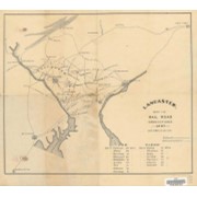
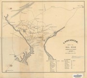
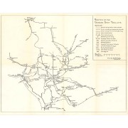
Shows lines for P.W. and B.R.R., B. and O. R.R., Balt. Cent. R.R., P.B.N.G.R.R., C. and P.D.R.R., P.B.R.R., Reading and CHesapeake R.R., CHes. Val. R.R., Lanc. and Del. R.R., Colebrok Valley R.R., and P. and R.R.R.
Subjects
Railroads - Pennsylvania - Lancaster County - Maps.
Mines and mineral resources - Pennsylvania - Lancaster County - Maps.
Location
Lancaster History Library - Map
Call Number
974.815 LACO 151
Documents

map_974.815_LACO_151_.pdf

Read PDF Download PDF
Less detail

Map of the early roads of Lancaster County, Pa. 1714 to 1760

https://collections.lancasterhistory.org/en/permalink/lhdo15379
Author
Eshleman, H. Frank
Date of Publication
1922]
Call Number
974.815 LACO 158
974.815 LACO 506
  1 document  
Alternate Title
Outline of Lancaster County Penna., townships, streams, etc.
Responsibility
compiled from the records of the courts by H. Frank Eshleman.
Author
Eshleman, H. Frank
Place of Publication
[S.l
Publisher
s.n.,
Date of Publication
1922]
Physical Description
1 map : photoreproduction, 2 col. ; 23 x 24 cm.
Notes
Scale of original map: [ca. 1:316,800]. 1 in. - 5 mi.
Map of early roads of Lancaster County depicted in red outline; Outline of Lancaster County, Penna. townships, streams, etc. depicted in blue outline.
LCHS has 2 copies 60 x 60 cm. with scale 1in.=2mi.
LCHS has 4 copies 23 x 24 cm. with scale 1in.=5mi.
The figures show number and page of Road Docket.
Appears in LCHS Journal, v. 26, no. 3.
Subjects
Roads - Pennsylvania - Lancaster County - Maps.
Rivers - Pennsylvania - Lancaster County - Maps.
Lancaster County (Pa.) - Maps.
Location
Lancaster History Library - Map
Call Number
974.815 LACO 158
974.815 LACO 506
Documents

map_974.815_LACO_158_.pdf

Read PDF Download PDF
Less detail

Routes of the Garden Spot Trolleys map

https://collections.lancasterhistory.org/en/permalink/lhdo5479
Date of Publication
1977.
Call Number
974.815 SEPA 102
  1 document  
Responsibility
Drawn by B. W. Rohrbeck.
Place of Publication
[s.l.]
Publisher
[s.n.] ,
Date of Publication
1977.
Physical Description
1 map ; 36 x 46 cm.
Notes
Includes route names.
Subjects
Street-railroads - Pennsylvania - Lancaster County
Transportation - Pennsylvania - Lancaster County
Lancaster County (Pa.) - Maps.
Location
Lancaster History Library - Map
Call Number
974.815 SEPA 102
Documents

map_974.815_SEPA_102_.pdf

Read PDF Download PDF
Less detail

Relative position of the government buildings in 1776, Lancaster, Pa

https://collections.lancasterhistory.org/en/permalink/lhdo1852
Date of Publication
n.d.
Call Number
974.815 LACI 114
  1 document  
Place of Publication
[S.l.]
Publisher
[s.n.] ,
Date of Publication
n.d.
Physical Description
1 map. 24 x 15 cm.
Notes
Pictorial map showing government warehouse, powder-house, barracks and government stables.
Subjects
Historic buildings - Pennsylvania - Lancaster
Lancaster (Pa.) - Maps.
Location
Lancaster History Library - Map
Call Number
974.815 LACI 114
Documents

map_974.815_LACI_114_.pdf

Read PDF Download PDF
Less detail
Call Number
974.815 CONO 100
  1 document  
Alternate Title
Conoy Township map.
Physical Description
1 map : photocopy ; 41 x 27 cm.
Notes
"Farmers Atlas 1977 from Archives Division."--Penciled on verso.
Subjects
Real property - Pennsylvania - Conoy (Township) - Maps.
Conoy (Pa. : Township) - Maps.
Location
Lancaster History Library - Map
Call Number
974.815 CONO 100
Documents

map_974.815_CONO_100_.pdf

Read PDF Download PDF
Less detail

Central park trails and facilities

https://collections.lancasterhistory.org/en/permalink/lhdo15692
Corporate Author
Lancaster County (Pa.). Dept. of Parks and Recreation.
Date of Publication
[19--?]
Call Number
974.815 LACO 148b
  1 document  
Alternate Title
Central Park trail guide
Responsibility
Lancaster County Department of Parks and Recreation.
Corporate Author
Lancaster County (Pa.). Dept. of Parks and Recreation.
Place of Publication
Lancaster, PA
Publisher
Lancaster County Dept. of Parks and Recreation,
Date of Publication
[19--?]
Physical Description
1 map : col., col. ill. ; 24 x 38 cm., folded to 22 x 10 cm.
Notes
Oriented with north toward the lower right.
Includes location map (inset), and legend.
Includes trail descriptions (text), color illustrations and table on verso.
Contents
Fitness trail -- Equestrian / X-country ski trail -- CVA trail -- Conestoga trail system -- Kinglet trail -- Mill Creek trail -- Oak trail -- Scout trail -- Warbler trail -- Wildflower trail.
Subjects
Trails - Pennsylvania - Lancaster County - Maps.
Lancaster County Central Park (Pa.) - Maps.
Lancaster County Central Park (Pa.) - Maps, Pictorial.
Location
Lancaster History Library - Map
Call Number
974.815 LACO 148b
Documents

map_974.815_LACO_148b_.pdf

Read PDF Download PDF
Less detail

10 records – page 1 of 1.