Skip header and navigation

Revise Search

10 records – page 1 of 1.

Collection
General Collection
Object ID
1-09-03-87
Date Range
August 1956
  1 image  
Object Name
Print, Photographic
Collection
General Collection
Description
Wabank Mill Bridge, also called Third Lock Bridge, on the Conestoga River between Lancaster and Pequea townships.
Provenance
Lancaster County covered bridge photos taken by M. E. Schroll and Kathryn L. Sauder taken between 1956 and 1958.
Date Range
August 1956
Storage Location
LancasterHistory, Lancaster, PA
Subcategory
Documentary Artifact
Search Terms
Bridges
Conestoga River
Covered bridges
Creeks
Lancaster Twp.
Mills
Pequea Twp.
Third Lock Bridge
Wabank Mill
Wabank Mill Bridge
Object Name
Print, Photographic
Print Size
3.5 x 3.5 inches
Condition
Good
Object ID
1-09-03-87
Images
Less detail
Collection
General Collection
Object ID
1-09-03-88
Date Range
August 7, 1958
  1 image  
Object Name
Print, Photographic
Collection
General Collection
Description
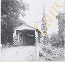
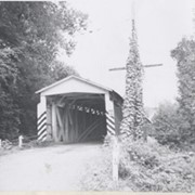
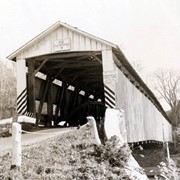
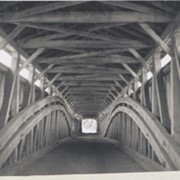
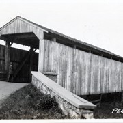
Wabank Mill bridge, also called Third Lock bridge, on the Conestoga River between Lancaster and Pequea townships. This bridge was replaced by a road relocation in 1958.
Provenance
Lancaster County covered bridge photos taken by M. E. Schroll and Kathryn L. Sauder taken between 1956 and 1958.
Date Range
August 7, 1958
Storage Location
LancasterHistory, Lancaster, PA
Subcategory
Documentary Artifact
Search Terms
Bridges
Conestoga River
Covered bridges
Creeks
Lancaster Twp.
Mills
Pequea Twp.
Third Lock Bridge
Wabank Mill
Wabank Mill Bridge
Object Name
Print, Photographic
Print Size
3.5 x 3.5 inches
Condition
Good
Object ID
1-09-03-88
Images
Less detail
Collection
General Collection
Object ID
1-09-03-89
Date Range
August 1956
  1 image  
Object Name
Print, Photographic
Collection
General Collection
Description
Covered bridge, Possibly Second Lock bridge, on the Conestoga River north of New Danville between Pequea and Lancaster townships.
Provenance
Lancaster County covered bridge photos taken by M. E. Schroll and Kathryn L. Sauder taken between 1956 and 1958.
Date Range
August 1956
Storage Location
LancasterHistory, Lancaster, PA
Subcategory
Documentary Artifact
Search Terms
Covered bridges
Second Lock Bridge
Conestoga River
New Danville, Pequea Twp.
Pequea Twp.
Lancaster Twp.
Object Name
Print, Photographic
Print Size
3.5 x 3.5 inches
Condition
Good
Object ID
1-09-03-89
Images
Less detail
Collection
General Collection
Object ID
1-09-03-90
Date Range
August 7, 1958
  1 image  
Object Name
Print, Photographic
Collection
General Collection
Description
Possibly Second Lock bridge over the Conestoga north of New Danville between Pequea and Lancaster townships.
Provenance
Lancaster County covered bridge photos taken by M. E. Schroll and Kathryn L. Sauder taken between 1956 and 1958.
Date Range
August 7, 1958
Storage Location
LancasterHistory, Lancaster, PA
Subcategory
Documentary Artifact
Search Terms
Second Lock Bridge
Conestoga River
New Danville, Pequea Twp.
Pequea Twp.
Lancaster Twp.
Covered bridges
Object Name
Print, Photographic
Print Size
3.5 x 3.5 inches
Condition
Good
Object ID
1-09-03-90
Images
Less detail
Collection
General Collection
Object ID
1-09-05-43
  1 image  
Object Name
Print, Photographic
Collection
General Collection
Description
Wabank bridge between New Danville and Millersville in Pequea Township on the Conestoga River. Double span, 246 feet long, built in 1841.
Provenance
digital image only - original owned by Milton Haldeman
Storage Location
LancasterHistory, Lancaster, PA
Subcategory
Documentary Artifact
Search Terms
Bridges
Conestoga River
Covered bridges
Millersville
New Danville, Pequea Twp.
Pequea Twp.
Wabank Bridge
Place
Pequea Twp.
Object Name
Print, Photographic
Condition
Good
Object ID
1-09-05-43
Images
Less detail
Collection
General Collection
Object ID
1-09-03-92
Date Range
November 12, 1958
  1 image  
Object Name
Print, Photographic
Collection
General Collection
Description
Possibly Second Lock bridge interior - on the Big Conestoga. Double arch, longest in county. Between Lancaster and Pequea townships.
Provenance
Lancaster County covered bridge photos taken by M. E. Schroll and Kathryn L. Sauder taken between 1956 and 1958.
Date Range
November 12, 1958
Storage Location
LancasterHistory, Lancaster, PA
Subcategory
Documentary Artifact
Search Terms
Second Lock Bridge
Conestoga River
Lancaster Twp.
Pequea Twp.
Covered bridges
Object Name
Print, Photographic
Print Size
3.5 x 3.5 inches
Condition
Good
Object ID
1-09-03-92
Images
Less detail
Collection
General Collection
Title
Photograph- Umble's Mill bridge over the Conestoga River near Eden. Built in 1848, 158 feet long.
Object ID
1-07-01-92
  1 image  
Object Name
Print, Photographic
Collection
General Collection
Title
Photograph- Umble's Mill bridge over the Conestoga River near Eden. Built in 1848, 158 feet long.
Description
Umble's Mill bridge over the Conestoga River near Eden. Built in 1848, 158 feet long.
Storage Location
LancasterHistory, Lancaster, PA
Subcategory
Documentary Artifact
Search Terms
Bridges
Conestoga River
Covered bridges
Eden, Manheim Twp.
Mills
Umble's Mill
Umble's Mill Bridge
Place
Manheim Twp.
Object Name
Print, Photographic
Print Size
2 x 3 inches
Object ID
1-07-01-92
Images
Less detail
Collection
Covered Bridge Safari Album
Object ID
A-65-01-27
  1 image  
Object Name
Print, Photographic
Collection
Covered Bridge Safari Album
Description
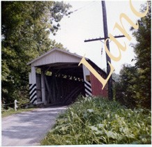
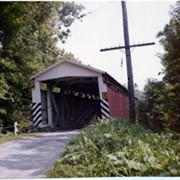
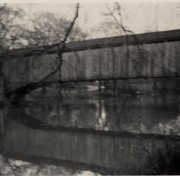
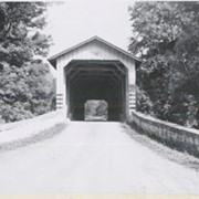
Snavely's Mill covered bridge, also called Second Lock covered bridge, destroyed by fire in 1968. Spanned the Conestoga Creek between Lancaster and Pequea Townships.
Provenance
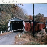
Photographs of a 2003 Theodore Burr Covered Bridge Society bridge safari.
Storage Location
LancasterHistory, Lancaster, PA
Subcategory
Documentary Artifact
Search Terms
Covered bridges
Bridges
Snavely's Mill bridge
Second Lock bridge
Conestoga Creek
Place
Lancaster Twp.
Object Name
Print, Photographic
Object ID
A-65-01-27
Images
Less detail
Collection
General Collection
Object ID
1-20-05-99
  1 image  
Object Name
Print, Photographic
Collection
General Collection
Description
Possibly Baumgardner's Mill Covered Bridge, also called Horse Hollow Covered Bridge, on Pequea Creek. Identified as bridge #19.
Provenance
Photographs taken by Lancaster County during bridge repair work. Gift of Gordon Reed.
Year Range From
1920
Year Range To
1929
Storage Location
LancasterHistory, Lancaster, PA
Search Terms
Covered bridges
Pequea Creek
Horse Hollow, Conestoga Twp.
Baumgardner's Mill Covered Bridge
Place
Pequea Twp.
Object Name
Print, Photographic
Print Size
3.25 x 5.5 inches
Object ID
1-20-05-99
Images
Less detail
Collection
General Collection
Title
Photograph- End view of Kurtz's Mill covered bridge across Big Conestoga, north of Fairmount.
Object ID
1-09-03-34
Date Range
August 1956
  1 image  
Object Name
Print, Photographic
Collection
General Collection
Title
Photograph- End view of Kurtz's Mill covered bridge across Big Conestoga, north of Fairmount.
Description
End view of Kurtz's Mill covered bridge across Big Conestoga.
Provenance
Lancaster County covered bridge photos taken by M. E. Schroll and Kathryn L. Sauder taken between 1956 and 1958.
Date Range
August 1956
Storage Location
LancasterHistory, Lancaster, PA
Subcategory
Documentary Artifact
Search Terms
Covered bridges
Conestoga River
Kurtz's Mill Covered Bridge
Martindale, Earl Twp.
Place
Earl Twp.
Object Name
Print, Photographic
Print Size
3.5 x 3.5 inches
Condition
Good
Object ID
1-09-03-34
Images
Less detail

10 records – page 1 of 1.