It appears no script is enabled within your browser. Please enable JavaScript to use this site.
Skip header and navigation
Toggle navigation
Collections
Search
Help
Privacy
Your Selections:
0
Items
Staff Login
Revise Search
Revise Search
Revise search
Search
Data Source
Photographs
166
×
Data Source
All
A
B
C
D
E
F
G
H
I
J
K
L
M
N
O
P
Q
R
S
T
U
V
W
X
Y
Z
Sort
By Count
Alphabetical
Filtered by
Filter
Loading...
Collection
General Collection
138
Covered Bridge Album
21
Mildred Shopf Smiley Photograph Collection
4
Lancaster 250 Collection
2
Railroad Album
1
×
Collection
All
A
B
C
D
E
F
G
H
I
J
K
L
M
N
O
P
Q
R
S
T
U
V
W
X
Y
Z
Sort
By Count
Alphabetical
Filtered by
Filter
Loading...
Subject
Documentary Artifact
Covered bridges
106
Bridges
33
Conestoga River
24
West King Street
20
Manuscript groups
18
Mills
18
Pequea Creek
18
Finding aids
16
North Prince Street
13
Stores
13
Big Chickies Creek
12
More
×
Subject
All
A
B
C
D
E
F
G
H
I
J
K
L
M
N
O
P
Q
R
S
T
U
V
W
X
Y
Z
Sort
By Count
Alphabetical
Filtered by
Filter
Loading...
Name
Gaintner, Jay Richard
21
Bond, George Ross
8
Walter, Ross
8
Harper, Ray
5
Courson, Ada
2
Mann, George
2
Bear, Isaac
1
Beck, Herbert
1
Bender, Charles M.
1
Chambers, David F.
1
Courson, Howard
1
Good, Daniel
1
More
×
Name
All
A
B
C
D
E
F
G
H
I
J
K
L
M
N
O
P
Q
R
S
T
U
V
W
X
Y
Z
Sort
By Count
Alphabetical
Filtered by
Filter
Loading...
Place
Lancaster
34
Manheim Twp.
6
Bart Twp.
5
East Cocalico Twp.
5
Ephrata Twp.
5
Caernarvon Twp.
4
East Earl Twp.
4
Colerain Twp.
3
East Hempfield Twp.
3
Eden Twp.
3
Paradise Twp.
3
Rapho Twp.
3
More
×
Place
All
A
B
C
D
E
F
G
H
I
J
K
L
M
N
O
P
Q
R
S
T
U
V
W
X
Y
Z
Sort
By Count
Alphabetical
Filtered by
Filter
Loading...
Decade
1740s
5
1750s
21
1760s
3666
1770s
3644
1780s
3674
1790s
3824
1800s
3813
1810s
6409
1820s
6445
1830s
6284
1840s
7859
1850s
5659
1860s
5065
1870s
4298
1880s
7557
1890s
7593
1900s
7576
1910s
1523
1920s
182
1930s
76
1940s
66
1950s
1960s
106
1970s
124
1980s
309
1990s
202
2000s
202
2010s
2
×
Decade
All
A
B
C
D
E
F
G
H
I
J
K
L
M
N
O
P
Q
R
S
T
U
V
W
X
Y
Z
Sort
By Count
Alphabetical
Filtered by
Filter
Loading...
Material
Print, Photographic
166
×
Material
All
A
B
C
D
E
F
G
H
I
J
K
L
M
N
O
P
Q
R
S
T
U
V
W
X
Y
Z
Sort
By Count
Alphabetical
Filtered by
Filter
Loading...
Online Media
Image
166
×
Online Media
All
A
B
C
D
E
F
G
H
I
J
K
L
M
N
O
P
Q
R
S
T
U
V
W
X
Y
Z
Sort
By Count
Alphabetical
Filtered by
Filter
Loading...
Advanced Search
Help
more like: A55D726A-9198-4B12-8332-373330512720
1950s
Documentary Artifact
Sorted by
Relevance
Sort by Title
Expand All
Collapse All
List View
Gallery View
Print
10 records – page 1 of 1.
Prev
Next
Toggle Full Record
Print, Photographic
https://collections.lancasterhistory.org/en/permalink/4bbec65e-0210-44c9-9eec-452372049972
Collection
General Collection
Object ID
1-09-04-03
Date Range
August 5, 1958
More detail
1 image
Object Name
Print, Photographic
Collection
General Collection
Description
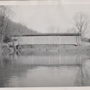
Zook's Mill covered bridge on the Cocalico Creek on Log Cabin Road west of Brownstown between West Earl and Warwick townships.
Provenance
Lancaster County covered bridge photos taken by M. E. Schroll and Kathryn L. Sauder taken between 1956 and 1958.
Date Range
August 5, 1958
Storage Location
LancasterHistory, Lancaster, PA
Subcategory
Documentary Artifact
Search Terms
Bridges
Brownstown, West Earl Twp.
Cocalico Creek
Covered bridges
Creeks
Log Cabin Road
Rose Hill Bridge
Warwick Twp.
West Earl Twp.
Zook's Mill
Object Name
Print, Photographic
Print Size
3.5 x 4.5 inches
Condition
Good
Object ID
1-09-04-03
Images
Less detail
More Like This
Permalink
Toggle Full Record
Print, Photographic
https://collections.lancasterhistory.org/en/permalink/adf748a2-38eb-4fbc-9b00-493564116246
Collection
General Collection
Title
Photograph- White Rock covered bridge over the West Branch of the Octoraro Creek between Colerain and Little Britain townships.
Object ID
1-09-03-53
Date Range
September 1956
More detail
1 image
Object Name
Print, Photographic
Collection
General Collection
Title
Photograph- White Rock covered bridge over the West Branch of the Octoraro Creek between Colerain and Little Britain townships.
Description
White Rock covered bridge over the West Branch of the Octoraro Creek between Colerain and Little Britain townships.
Provenance
Lancaster County covered bridge photos taken by M. E. Schroll and Kathryn L. Sauder taken between 1956 and 1958.
Date Range
September 1956
Storage Location
LancasterHistory, Lancaster, PA
Subcategory
Documentary Artifact
Search Terms
Bridges
Colerain Twp.
Covered bridges
Creeks
Octoraro Creek, West Branch
White Rock Covered Bridge
White Rock Forge Covered Bridge
White Rock, Little Britain Twp.
Object Name
Print, Photographic
Print Size
3.5 x 3.5 inches
Condition
Good
Object ID
1-09-03-53
Images
Less detail
More Like This
Permalink
Toggle Full Record
Print, Photographic
https://collections.lancasterhistory.org/en/permalink/aee09825-bd3d-4c64-85d9-210349253712
Collection
General Collection
Title
Photograph- White Rock covered bridge over the West Branch of the Octoraro Creek between Colerain and Little Britain townships.
Object ID
1-09-03-54
Date Range
August 4, 1958
More detail
1 image
Object Name
Print, Photographic
Collection
General Collection
Title
Photograph- White Rock covered bridge over the West Branch of the Octoraro Creek between Colerain and Little Britain townships.
Description
White Rock covered bridge over the West Branch of the Octoraro Creek between Colerain and Little Britain townships.
Provenance
Lancaster County covered bridge photos taken by M. E. Schroll and Kathryn L. Sauder taken between 1956 and 1958.
Date Range
August 4, 1958
Storage Location
LancasterHistory, Lancaster, PA
Subcategory
Documentary Artifact
Search Terms
Bridges
Colerain Twp.
Covered bridges
Creeks
Octoraro Creek, West Branch
White Rock Covered Bridge
White Rock Forge Covered Bridge
White Rock, Little Britain Twp.
Object Name
Print, Photographic
Print Size
3.5 x 3.5 inches
Condition
Good
Object ID
1-09-03-54
Images
Less detail
More Like This
Permalink
Toggle Full Record
Print, Photographic
https://collections.lancasterhistory.org/en/permalink/dd0e11ff-70e7-4dc0-8d36-073257198050
Collection
General Collection
Object ID
1-09-03-63
Date Range
August 1956
More detail
1 image
Object Name
Print, Photographic
Collection
General Collection
Description
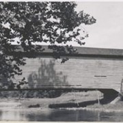
Herrville covered bridge across the Pequea Creek south of Lime Valley.
Provenance
Lancaster County covered bridge photos taken by M. E. Schroll and Kathryn L. Sauder taken between 1956 and 1958.
Date Range
August 1956
Storage Location
LancasterHistory, Lancaster, PA
Subcategory
Documentary Artifact
Search Terms
Bridges
Covered bridges
Herrville, Pequea Twp.
Lime Valley, West Lampeter Twp.
Pequea Creek
Object Name
Print, Photographic
Print Size
3.5 x 3.5 inches
Condition
Good
Object ID
1-09-03-63
Images
Less detail
More Like This
Permalink
Toggle Full Record
Print, Photographic
https://collections.lancasterhistory.org/en/permalink/4ae27840-0787-4b12-80cc-309352173194
Collection
General Collection
Object ID
1-09-03-64
Date Range
August 1958
More detail
1 image
Object Name
Print, Photographic
Collection
General Collection
Description
Herrville covered bridge on the Pequea Creek south of Lime Valley.
Provenance
Lancaster County covered bridge photos taken by M. E. Schroll and Kathryn L. Sauder taken between 1956 and 1958.
Date Range
August 1958
Storage Location
LancasterHistory, Lancaster, PA
Subcategory
Documentary Artifact
Search Terms
Bridges
Covered bridges
Herrville, Pequea Twp.
Lime Valley, West Lampeter Twp.
Pequea Creek
Object Name
Print, Photographic
Print Size
3.5 x 3.5 inches
Condition
Good
Object ID
1-09-03-64
Images
Less detail
More Like This
Permalink
Toggle Full Record
Print, Photographic
https://collections.lancasterhistory.org/en/permalink/69f030a4-faf6-466e-a4ad-467078315846
Collection
General Collection
Object ID
1-09-04-02
Date Range
July 1956
More detail
1 image
Object Name
Print, Photographic
Collection
General Collection
Description
Zook's Mill covered bridge across the Cocalico Creek south of Akron between West Earl and Warwick townships.
Provenance
Lancaster County covered bridge photos taken by M. E. Schroll and Kathryn L. Sauder taken between 1956 and 1958.
Date Range
July 1956
Storage Location
LancasterHistory, Lancaster, PA
Subcategory
Documentary Artifact
Search Terms
Zook's Mill
Covered bridges
Cocalico Creek
Akron, Pennsylvania
West Earl Twp.
Warwick Twp.
Creeks
Rose Hill Bridge
Object Name
Print, Photographic
Print Size
3.5 x 4.5 inches
Condition
Good
Object ID
1-09-04-02
Images
Less detail
More Like This
Permalink
Toggle Full Record
Print, Photographic
https://collections.lancasterhistory.org/en/permalink/1e9a2243-81fd-4997-9fc4-232342361435
Collection
Covered Bridge Album
Object ID
A-11-01-28
Date Range
1950
More detail
1 image
Object Name
Print, Photographic
Collection
Covered Bridge Album
Description
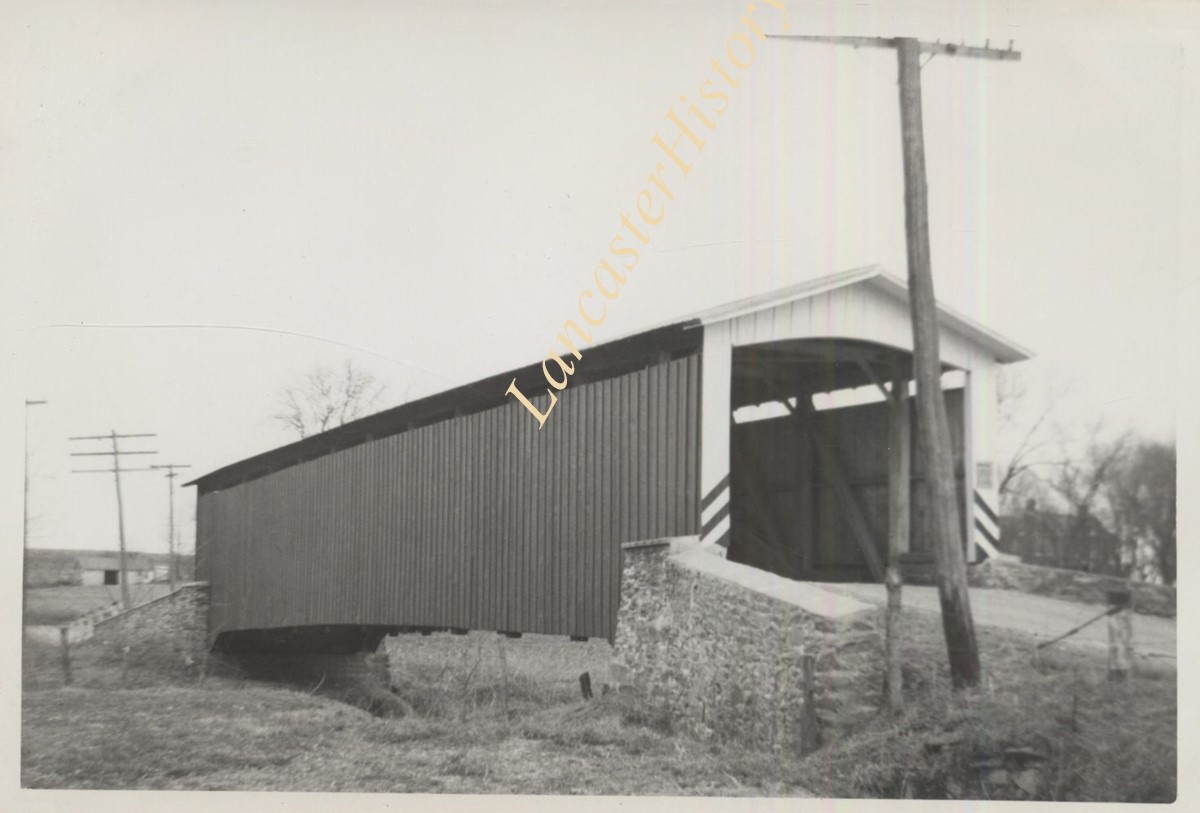
Hurtzinger's Mill, at Lime Valley, between Strasburg and West Lampeter Townships. County maintained on road T-498, built in 1871, single span 104 feet long.
Date Range
1950
Creator
Gaintner, Jay Richard
Storage Location
LancasterHistory, Lancaster, PA
Subcategory
Documentary Artifact
Search Terms
Bridges
Covered bridges
Mills
Pequea Creek
Lime Valley, West Lampeter Twp.
Object Name
Print, Photographic
Print Size
8 x 10 inches
Object ID
A-11-01-28
Images
Less detail
More Like This
Permalink
Toggle Full Record
Print, Photographic
https://collections.lancasterhistory.org/en/permalink/b876eb4b-f5aa-4612-8081-524846067071
Collection
Covered Bridge Album
Object ID
A-11-01-40
Date Range
1950
More detail
1 image
Object Name
Print, Photographic
Collection
Covered Bridge Album
Description
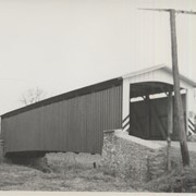
White Rock Forge, between Colerain and Little Britain Townships. County maintained on road T-337, built in 1847, single span 87 feet long.
Date Range
1950
Creator
Gaintner, Jay Richard
Storage Location
LancasterHistory, Lancaster, PA
Subcategory
Documentary Artifact
Search Terms
Bridges
Covered bridges
Forges
Octoraro Creek, West Branch
White Rock Covered Bridge
White Rock Forge
White Rock Forge Covered Bridge
White Rock, Little Britain Twp.
Object Name
Print, Photographic
Print Size
8 x 10 inches
Object ID
A-11-01-40
Images
Less detail
More Like This
Permalink
Toggle Full Record
Print, Photographic
https://collections.lancasterhistory.org/en/permalink/296c6673-3a37-4258-bea2-449609487490
Collection
General Collection
Title
Photograph- Side view of King's Bridge on the West Branch of the Octoraro northwest of White Rock, between Colerain and Little Britain townships.
Object ID
1-09-03-51
Date Range
September 1, 1958
More detail
1 image
Object Name
Print, Photographic
Collection
General Collection
Title
Photograph- Side view of King's Bridge on the West Branch of the Octoraro northwest of White Rock, between Colerain and Little Britain townships.
Description
Side view of King's Bridge on the West Branch of the Octoraro northwest of White Rock, between Colerain and Little Britain townships.
Provenance
Lancaster County covered bridge photos taken by M. E. Schroll and Kathryn L. Sauder taken between 1956 and 1958.
Date Range
September 1, 1958
Storage Location
LancasterHistory, Lancaster, PA
Subcategory
Documentary Artifact
Search Terms
Bridges
King's Bridge
Covered bridges
Octoraro Creek, West Branch
White Rock, Little Britain Twp.
Creeks
Object Name
Print, Photographic
Print Size
3.5 x 3.5 inches
Condition
Good
Object ID
1-09-03-51
Images
Less detail
More Like This
Permalink
Toggle Full Record
Print, Photographic
https://collections.lancasterhistory.org/en/permalink/5e93a77a-b151-4c88-95ba-423210273245
Collection
General Collection
Object ID
1-09-03-79
Date Range
August 13, 1958
More detail
1 image
Object Name
Print, Photographic
Collection
General Collection
Description
Bitzer's Mill covered bridge, also called Eberly's Cider Mill covered bridge, on the Conestoga River north of Fairmount.
Provenance
Lancaster County covered bridge photos taken by M. E. Schroll and Kathryn L. Sauder taken between 1956 and 1958.
Date Range
August 13, 1958
Storage Location
LancasterHistory, Lancaster, PA
Subcategory
Documentary Artifact
Search Terms
Bitzer's Mill
Covered bridges
Eberly's Cider Mill
Conestoga River
Fairmount, West Earl Twp.
Place
West Earl Twp.
Object Name
Print, Photographic
Print Size
3.5 x 3.5 inches
Condition
Good
Object ID
1-09-03-79
Images
Less detail
More Like This
Permalink
10 records – page 1 of 1.
Prev
Next