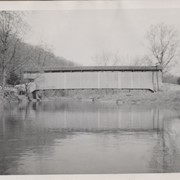
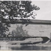
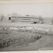
Photograph- Bell Bank covered bridge across the Octoraro Creek four miles south of Nine Points, between Colerain Township, Lancaster County and Upper Oxford Township, Chester County.
Photograph- Bell Bank covered bridge across the Octoraro Creek four miles south of Nine Points, between Colerain Township, Lancaster County and Upper Oxford Township, Chester County.
Description
Bell Bank covered bridge across the Octoraro Creek four miles south of Nine Points, between Colerain Township, Lancaster County and Upper Oxford Township, Chester County.
Provenance
Lancaster County covered bridge photos taken by M. E. Schroll and Kathryn L. Sauder taken between 1956 and 1958.
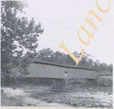
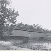
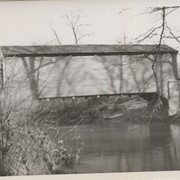
Photograph- Pine Grove covered bridge across the Octoraro Creek, between Little Britain Township, Lancaster County, and Lower Oxford Township, Chester County. Location of pumping station which supplies Chester.
Photograph- Pine Grove covered bridge across the Octoraro Creek, between Little Britain Township, Lancaster County, and Lower Oxford Township, Chester County. Location of pumping station which supplies Chester.
Description
Pine Grove Covered Bridge across the Octoraro Creek, between Little Britain Township, Lancaster County, and Lower Oxford Township, Chester County. Location of pumping station which supplies Chester.
Provenance
Lancaster County covered bridge photos taken by M. E. Schroll and Kathryn L. Sauder taken between 1956 and 1958.
Bellbank Bridge, 2.5 miles east of Union in Colerain Township. State supervised on road LR 36022, built in 1861 (first bridge 1850), single span 131 feet long.
Worth's Bridge, 2.5 miles southeast of Union in Colerain Township. County maintained on road T-764, built in 1857 (first bridge 1841), single span 60 feet long.
Pine Grove Covered Bridge in Little Britain Township. State supervised on road LR 36018, built in 1884 (first bridge 1815, second bridge 1846), double span 204 feet long.