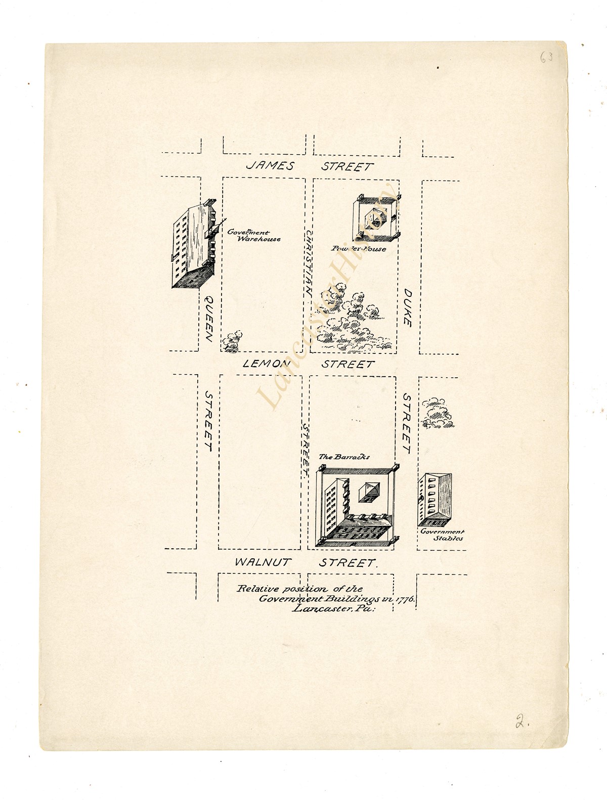
"Relative position of the Government Buildings in 1776. Lancaster, Pa."
Description
Print of map of Lancaster city. "Relative position of the Government Buildings in 1776. Lancaster, Pa."
The map shows four blocks--James Street, Queen Street, Walnut Street, Duke Street, Lemon Street, and Christian Street--with sketches of the Government Warehouse, the Powder House, the Barracks, and the Government Stables.
George Steinman Papers, Series 1 (MG0184_S01) https://collections.lancasterhistory.org/en/permalink/786b3ffc-7908-40de-9362-817467455650
George Steinman Papers, Series 2 (MG0184_S02) https://collections.lancasterhistory.org/en/permalink/6c7e11c6-f3ca-469c-891a-145832196710
Notes
Preferred Citation: Title or description of item, date (day, month, year), George Steinman Papers (MG0184), Series 2, Object ID, LancasterHistory, Lancaster, Pennsylvania. URL if applicable. Date accessed (day, month, year).
Access Conditions / Restrictions
Please use digital images and transcriptions when available. Original documents may be used by appointment--contact Research@LancasterHistory.org prior to visit.
Copyright
Images have been provided for research purposes only. Please contact Research@LancasterHistory.org for a high-resolution image and permission to publish.
LancasterHistory retains the rights to the digital images and content presented. The doctrine of fair use allows limited use of copyrighted material without permission from the copyright holder. Fair use includes comment, criticism, teaching, and private scholarship. Any images and data downloaded, printed or photocopied for these purposes should provide a citation. All other uses beyond those allowed by fair use require written permission.
Permission for reproduction and/or publication must be obtained in writing from LancasterHistory. Persons wishing to publish any material from this site must assume all responsibility for identifying and satisfying any claimants of copyright or other use restrictions. Publication fees may apply.
Credit
Courtesy of LancasterHistory, Lancaster, Pennsylvania.
Other Numbers
MG-184, Series 2
Other Number
MG-184, Series 2, Folder 16, Item 2
Classification
MG0184
Description Level
Item
Custodial History
Added to database 12 September 2023.
Digitization of this document was funded by the Pennsylvania Historical and Museum Commission, PHMC Appl ID # C980002119, 2021-2024.
George Steinman Papers, Series 1 (MG0184_S01) https://collections.lancasterhistory.org/en/permalink/786b3ffc-7908-40de-9362-817467455650
George Steinman Papers, Series 2 (MG0184_S02) https://collections.lancasterhistory.org/en/permalink/6c7e11c6-f3ca-469c-891a-145832196710
Notes
Preferred Citation: Title or description of item, date (day, month, year), George Steinman Papers (MG0184), Series 2, Object ID, LancasterHistory, Lancaster, Pennsylvania. URL if applicable. Date accessed (day, month, year).
Access Conditions / Restrictions
Please use digital images and transcriptions when available. Original documents may be used by appointment--contact Research@LancasterHistory.org prior to visit.
Copyright
Images have been provided for research purposes only. Please contact Research@LancasterHistory.org for a high-resolution image and permission to publish.
LancasterHistory retains the rights to the digital images and content presented. The doctrine of fair use allows limited use of copyrighted material without permission from the copyright holder. Fair use includes comment, criticism, teaching, and private scholarship. Any images and data downloaded, printed or photocopied for these purposes should provide a citation. All other uses beyond those allowed by fair use require written permission.
Permission for reproduction and/or publication must be obtained in writing from LancasterHistory. Persons wishing to publish any material from this site must assume all responsibility for identifying and satisfying any claimants of copyright or other use restrictions. Publication fees may apply.
Credit
Courtesy of LancasterHistory, Lancaster, Pennsylvania.
Other Numbers
MG-184, Series 2
Other Number
MG-184, Series 2, Folder 49, Insert 1, Item 2
Classification
MG0184
Description Level
Item
Custodial History
Added to database 12 September 2023.
Digitization of this document was funded by the Pennsylvania Historical and Museum Commission, PHMC Appl ID # C980002119, 2021-2024.
Map of a ten mile radius of central Lancaster County showing Lancaster city, Millersburg (now Millersville), Conestoga Indian Town, and Strasburg.
"A ten miles square, Lancaster Court-House being in the centre, and some part beyond it, actually surveyed 1786 and 1787 by me, William Reichenbach, in a manner as engineers use to take up special maps of countries, by compass and watch.
Of this square two large and more complete copies on royal paper, and in fair handwriting, with explanations and descriptions of the country, were sent to Congress when the inhabitants of Lancaster offered this place for a seat of the general government."
George Steinman Papers, Series 1 (MG0184_S01) https://collections.lancasterhistory.org/en/permalink/786b3ffc-7908-40de-9362-817467455650
George Steinman Papers, Series 2 (MG0184_S02) https://collections.lancasterhistory.org/en/permalink/6c7e11c6-f3ca-469c-891a-145832196710
Notes
Preferred Citation: Title or description of item, date (day, month, year), George Steinman Papers (MG0184), Series 2, Object ID, LancasterHistory, Lancaster, Pennsylvania. URL if applicable. Date accessed (day, month, year).
Access Conditions / Restrictions
Please use digital images and transcriptions when available. Original documents may be used by appointment--contact Research@LancasterHistory.org prior to visit.
Copyright
Images have been provided for research purposes only. Please contact Research@LancasterHistory.org for a high-resolution image and permission to publish.
LancasterHistory retains the rights to the digital images and content presented. The doctrine of fair use allows limited use of copyrighted material without permission from the copyright holder. Fair use includes comment, criticism, teaching, and private scholarship. Any images and data downloaded, printed or photocopied for these purposes should provide a citation. All other uses beyond those allowed by fair use require written permission.
Permission for reproduction and/or publication must be obtained in writing from LancasterHistory. Persons wishing to publish any material from this site must assume all responsibility for identifying and satisfying any claimants of copyright or other use restrictions. Publication fees may apply.
Credit
Courtesy of LancasterHistory, Lancaster, Pennsylvania.
Other Numbers
MG-184, Series 2
Other Number
MG-184, Series 2, Folder 49, Insert 1, Item 3
Classification
MG0184
Description Level
Item
Custodial History
Added to database 13 September 2023.
Digitization of this document was funded by the Pennsylvania Historical and Museum Commission, PHMC Appl ID # C980002119, 2021-2024.
Insurance policy of Benjiman Hershey of Leacock Twp. from the Lancaster Mutual Insurance Company signed by Henry Slaymaker, Secretary and Samuel Duffield, President.
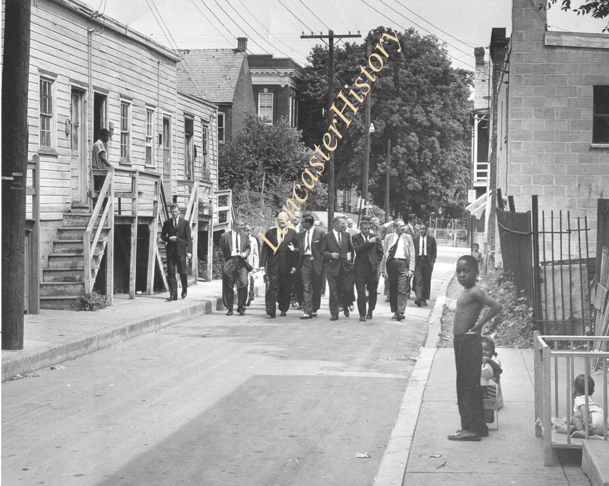
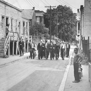
Lancaster's southeast quadrant, the seventh ward, shown with members of Lancaster City Council and Redevelopment Authority tour the area to be cleared in the 1960s. Mayor George Coe, with paper in paper in pocket, leads the group. W. Hensel Brown, Jr. is on the sidewalk at left.