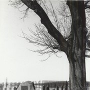
Boulder and bronze tablet at the site of Conestoga Indian Town. The town was located on the road from Letort to Safe Harbor in Manor Township between the years of 1682 and 1763. Monument erected in 1924.
Provenance
Album of historical markers erected by the Lancaster County Historical Society, compiled by George L. Heiges in 1986.
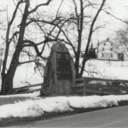
Boulder and bronze tablet at the site of Conoy Indian Town (1718 - 1743) near Bainbridge. It also honored the memory of French trader Peter Bezaillion. He laid out a road from this point to Compass, Chester County. Monument erected in 1933.
Provenance
Album of historical markers erected by the Lancaster County Historical Society, compiled by George L. Heiges in 1986.
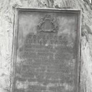
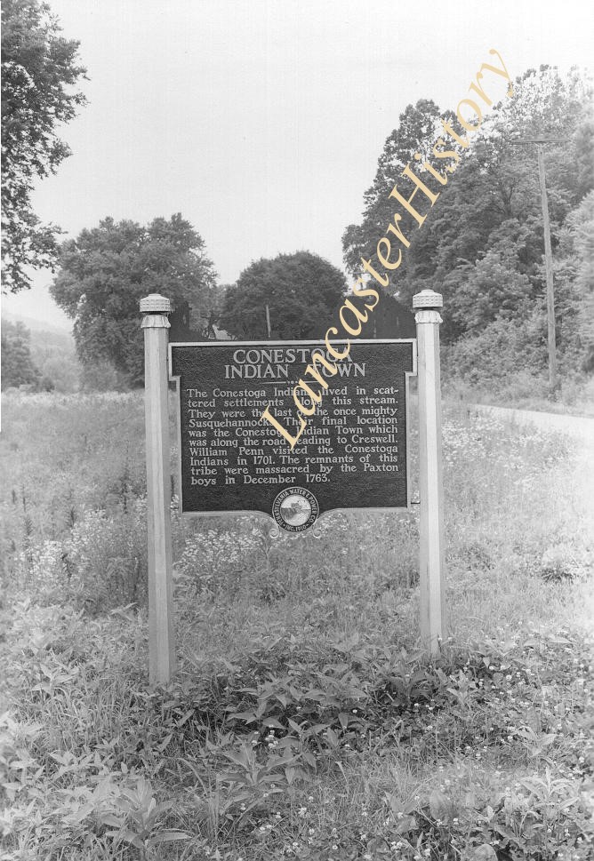
Historic marker placed by Pennsylvania Water and Power Company near Safe Harbor. Conestoga Indian Town. The Conestoga Indians lived in sacttered settlements along this stream. They were the last of the once mighty Susquehannocks. Their f
Historic marker placed by Pennsylvania Water and Power Company near Safe Harbor. Conestoga Indian Town. The Conestoga Indians lived in sacttered settlements along this stream. They were the last of the once mighty Susquehannocks. Their f
Description
Historic marker placed by Pennsylvania Water and Power Company near Safe Harbor. "Conestoga Indian Town. The Conestoga Indians lived in sacttered settlements along this stream. They were the last of the once mighty Susquehannocks. Their final location was the Conestoga Indian Town which was along the road leading to Creswell. William Penn visited the Conestoga indians in 1701. The remnants of this tribe were massacred by the Paxton boys in December 1763."
Historic marker placed by the Pennsylvania Water and Power Corporation near Safe Harbor.
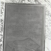
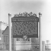
The Susquehannocks. The most warlike of all Indian tribes lived along this river. Thier power was broken in 1675 by a long war with the Five Natio
Description
Historic marker placed by the Pennsylvania Water and Power Corporation near Safe Harbor:
"The Susquehannocks. The most warlike of all Indian tribes lived along this river. Thier power was broken in 1675 by a long war with the Five Nations, and the Maryland and Virginia colonies. Fortified towns were located near Turkey Hill and near Long Level. An Indian exploration by the Pennsylvania Historical Commission and the Safe Harbor Water Power Corporation in 1930 recovered thousands of artifacts, now in the Pennsylvania State Museum at Harrisburg."
Historic marker placed by Pennsylvania Water and Power Company near Safe Harbor.
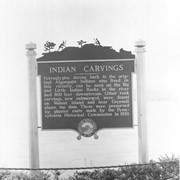
Indian Carvings. Petroglyphs, dating back to the original Algonquin Indians who lovedin this vicinity, can be seen on the Big and Little Indian Rocks in the
Historic marker placed by Pennsylvania Water and Power Company near Safe Harbor.
Indian Carvings. Petroglyphs, dating back to the original Algonquin Indians who lovedin this vicinity, can be seen on the Big and Little Indian Rocks in the
Description
Historic marker placed by Pennsylvania Water and Power Company near Safe Harbor.
"Indian Carvings. Petroglyphs, dating back to the original Algonquin Indians who lovedin this vicinity, can be seen on the Big and Little Indian Rocks in the river bed 800 feet downstream. Other rock carvings, now submerged, were found on Walnut Island and near Creswell above the dam. These were preserved by plaster casts made by the Pennsylvania Historical Commission in 1930."