Skip header and navigation

Revise Search

20 records – page 1 of 1.

Collection
General Collection
Object ID
1-20-04-99
  1 image  
Object Name
Print, Photographic
Collection
General Collection
Description
Bridge #2 over Cocalico Creek - possibly Bucher's Mill Covered Bridge
Provenance
Photographs taken by Lancaster County during bridge repair work. Gift of Gordon Reed.
Year Range From
1920
Year Range To
1929
Storage Location
LancasterHistory, Lancaster, PA
Search Terms
Bridges
Bucher's Mill
Bucher's Mill Covered Bridge
Cocalico Creek
Covered bridges
Creeks
East Cocalico Twp.
Mills
Place
East Cocalico Twp.
Object Name
Print, Photographic
Print Size
3.25 x 5.5 inches
Object ID
1-20-04-99
Images
Less detail
Collection
General Collection
Object ID
1-09-03-97
Date Range
September 1956
  1 image  
Object Name
Print, Photographic
Collection
General Collection
Description
Possibly Bucher's Mill Covered Bridge on the Cocalico Creek west of Reamstown.
Provenance
Lancaster County covered bridge photos taken by M. E. Schroll and Kathryn L. Sauder taken between 1956 and 1958.
Date Range
September 1956
Storage Location
LancasterHistory, Lancaster, PA
Subcategory
Documentary Artifact
Search Terms
Bucher's Mill
Covered bridges
Cocalico Creek
Reamstown, East Cocalico Twp.
Place
East Cocalico Twp.
Object Name
Print, Photographic
Print Size
3.5 x 3.5 inches
Condition
Good
Object ID
1-09-03-97
Images
Less detail
Collection
General Collection
Object ID
1-09-03-98
Date Range
August 4, 1958
  1 image  
Object Name
Print, Photographic
Collection
General Collection
Description
Possibly Bucher's Mill covered bridge on the Cocalico Creek west of Reamstown and east of Ephrata.
Provenance
Lancaster County covered bridge photos taken by M. E. Schroll and Kathryn L. Sauder taken between 1956 and 1958.
Date Range
August 4, 1958
Storage Location
LancasterHistory, Lancaster, PA
Subcategory
Documentary Artifact
Search Terms
Bucher's Mill
Covered bridges
Cocalico Creek
Reamstown, East Cocalico Twp.
Place
East Cocalico Twp.
Object Name
Print, Photographic
Print Size
3.5 x 3.5 inches
Condition
Good
Object ID
1-09-03-98
Images
Less detail
Collection
General Collection
Object ID
1-09-03-95
Date Range
August 1956
  1 image  
Object Name
Print, Photographic
Collection
General Collection
Description
Fry's Mill Covered Bridge on Muddy Creek south of Napierville.
Provenance
Lancaster County covered bridge photos taken by M. E. Schroll and Kathryn L. Sauder taken between 1956 and 1958.
Date Range
August 1956
Storage Location
LancasterHistory, Lancaster, PA
Subcategory
Documentary Artifact
Search Terms
Fry's Mill Covered Bridge
Covered bridges
Muddy Creek
Napierville, East Cocalico Twp.
Place
East Cocalico Twp.
Object Name
Print, Photographic
Print Size
3.5 x 3.5 inches
Condition
Good
Object ID
1-09-03-95
Images
Less detail
Collection
General Collection
Object ID
1-20-04-83
  1 image  
Object Name
Print, Photographic
Collection
General Collection
Description
Bridge #3 over Muddy Creek, possibly Fry's Mill Covered Bridge
Provenance
Photographs taken by Lancaster County during bridge repair work. Gift of Gordon Reed.
Year Range From
1920
Year Range To
1929
Storage Location
LancasterHistory, Lancaster, PA
Search Terms
Covered bridges
Muddy Creek
Frysville, East Cocalico Twp.
Fry's Mill Covered Bridge
Place
East Cocalico Twp.
Object Name
Print, Photographic
Print Size
3.25 x 5.5 inches
Object ID
1-20-04-83
Images
Less detail
Collection
General Collection
Title
Photograph- Bridge between Ephrata and Reamstown looking from Route 222
Object ID
1-05-03-48
Date Range
April 1948
  1 image  
Object Name
Print, Photographic
Collection
General Collection
Title
Photograph- Bridge between Ephrata and Reamstown looking from Route 222
Description
Bridge between Ephrata and Reamstown looking from Route 222
Date Range
April 1948
Storage Location
LancasterHistory, Lancaster, PA
Subcategory
Documentary Artifact
Search Terms
Bridges
Covered bridges
Reamstown, East Cocalico Twp.
Place
East Cocalico Twp.
Object Name
Print, Photographic
Object ID
1-05-03-48
Images
Less detail
Collection
General Collection
Object ID
1-09-04-03
Date Range
August 5, 1958
  1 image  
Object Name
Print, Photographic
Collection
General Collection
Description
Zook's Mill covered bridge on the Cocalico Creek on Log Cabin Road west of Brownstown between West Earl and Warwick townships.
Provenance
Lancaster County covered bridge photos taken by M. E. Schroll and Kathryn L. Sauder taken between 1956 and 1958.
Date Range
August 5, 1958
Storage Location
LancasterHistory, Lancaster, PA
Subcategory
Documentary Artifact
Search Terms
Bridges
Brownstown, West Earl Twp.
Cocalico Creek
Covered bridges
Creeks
Log Cabin Road
Rose Hill Bridge
Warwick Twp.
West Earl Twp.
Zook's Mill
Object Name
Print, Photographic
Print Size
3.5 x 4.5 inches
Condition
Good
Object ID
1-09-04-03
Images
Less detail
Collection
General Collection
Object ID
1-09-05-49
  1 image  
Object Name
Print, Photographic
Collection
General Collection
Description
Zook's Mill Bridge on Rose Hill Road near Log Cabin Road between Warwick and West Earl Townships on the Cocalico Creek. 89 feet long, built in 1849.
Provenance
digital image only - original owned by Milton Haldeman
Storage Location
LancasterHistory, Lancaster, PA
Subcategory
Documentary Artifact
Search Terms
Bridges
Cocalico Creek
Covered bridges
Creeks
Log Cabin Road
Rose Hill Road
Warwick Twp.
West Earl Twp.
Zook's Mill
Object Name
Print, Photographic
Condition
Good
Object ID
1-09-05-49
Images
Less detail
Collection
General Collection
Object ID
2-21-01-18
Date Range
August 3, 1959
  1 image  
Object Name
Print, Photographic
Collection
General Collection
Description
Covered Bridge south of Reamstown
Provenance
Donated by Deanna M. Nolder.
Loose pages from photo album belonging to donor's late grandfather, G.Ross Bond of York, PA.
Date Range
August 3, 1959
Creator
Bond, George Ross
Storage Location
LancasterHistory, Lancaster, PA
Subcategory
Documentary Artifact
Search Terms
Reamstown, East Cocalico Twp.
Covered bridges
Object Name
Print, Photographic
Print Size
4 x 4 inches
Condition
Good
Object ID
2-21-01-18
Images
Less detail
Collection
General Collection
Object ID
1-09-03-96
Date Range
August 7, 1958
  1 image  
Object Name
Print, Photographic
Collection
General Collection
Description
Fry's Covered Bridge near Napierville.
Provenance
Lancaster County covered bridge photos taken by M. E. Schroll and Kathryn L. Sauder taken between 1956 and 1958.
Date Range
August 7, 1958
Storage Location
LancasterHistory, Lancaster, PA
Subcategory
Documentary Artifact
Search Terms
Fry's Mill Covered Bridge
Napierville, East Cocalico Twp.
Covered bridges
Place
East Cocalico Twp.
Object Name
Print, Photographic
Print Size
3.5 x 3.5 inches
Condition
Good
Object ID
1-09-03-96
Images
Less detail
Collection
General Collection
Object ID
1-09-04-02
Date Range
July 1956
  1 image  
Object Name
Print, Photographic
Collection
General Collection
Description
Zook's Mill covered bridge across the Cocalico Creek south of Akron between West Earl and Warwick townships.
Provenance
Lancaster County covered bridge photos taken by M. E. Schroll and Kathryn L. Sauder taken between 1956 and 1958.
Date Range
July 1956
Storage Location
LancasterHistory, Lancaster, PA
Subcategory
Documentary Artifact
Search Terms
Zook's Mill
Covered bridges
Cocalico Creek
Akron, Pennsylvania
West Earl Twp.
Warwick Twp.
Creeks
Rose Hill Bridge
Object Name
Print, Photographic
Print Size
3.5 x 4.5 inches
Condition
Good
Object ID
1-09-04-02
Images
Less detail
Collection
General Collection
Object ID
1-20-05-11
  1 image  
Object Name
Print, Photographic
Collection
General Collection
Description
Bridge #13 over Cocalico Creek - Covered bridge on Log Cabin Road known as Zook's Mill Covered Bridge and Rose Hill Covered Bridge
Provenance
Photographs taken by Lancaster County during bridge repair work. Gift of Gordon Reed.
Year Range From
1920
Year Range To
1929
Storage Location
LancasterHistory, Lancaster, PA
Search Terms
Bridges
Cocalico Creek
Covered bridges
Creeks
Log Cabin Road
Rose Hill Bridge
West Earl Twp.
Zook's Mill Bridge
Object Name
Print, Photographic
Print Size
3.25 x 5.5 inches
Object ID
1-20-05-11
Images
Less detail
Collection
General Collection
Object ID
1-09-05-48
  1 image  
Object Name
Print, Photographic
Collection
General Collection
Description
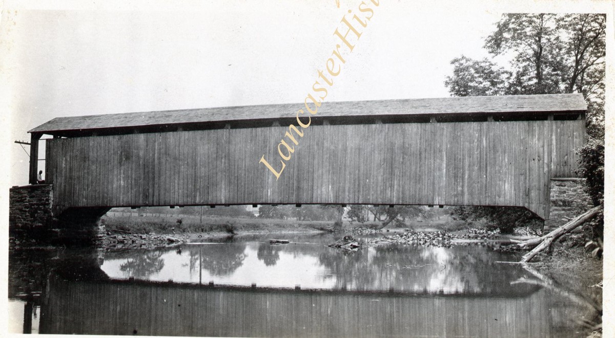
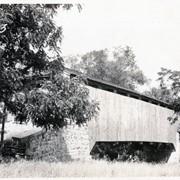
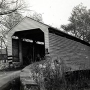
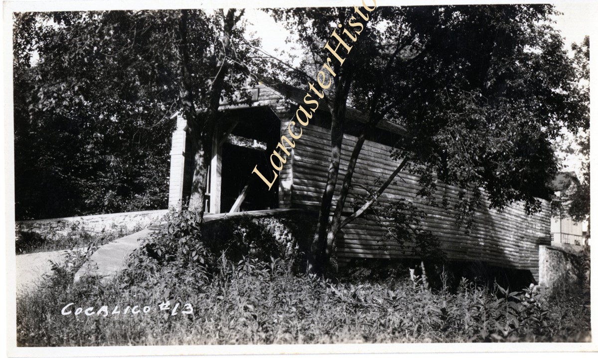
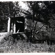
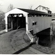
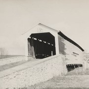
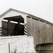
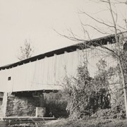
Keller's Mill bridge, also called Guy Bard's bridge, one and a half miles north of Arkon in Ephrata Township on the Cocalico Creek. 76 feet long, built in 1891.
Provenance
digital image only - original owned by Milton Haldeman
Storage Location
LancasterHistory, Lancaster, PA
Subcategory
Documentary Artifact
Search Terms
Keller's Mill Covered Bridge
Guy Bard's Covered Bridge
Akron, Pennsylvania
Cocalico Creek
Covered bridges
Place
Ephrata Twp.
Object Name
Print, Photographic
Condition
Good
Object ID
1-09-05-48
Images
Less detail
Collection
General Collection
Object ID
1-09-05-50
  1 image  
Object Name
Print, Photographic
Collection
General Collection
Description
Abram Hess Mill bridge, one mile north of Millway in Ephrata Township on the Cocalico Creek. 58 feet long, built in 1844.
Provenance
digital image only - original owned by Milton Haldeman
Storage Location
LancasterHistory, Lancaster, PA
People
Hess, Abram
Subcategory
Documentary Artifact
Search Terms
Abram Hess Mill
Millway, Warwick Twp.
Cocalico Creek
Covered bridges
Place
Ephrata Twp.
Object Name
Print, Photographic
Condition
Good
Object ID
1-09-05-50
Images
Less detail
Collection
General Collection
Object ID
1-09-05-51
  1 image  
Object Name
Print, Photographic
Collection
General Collection
Description
Samuel Erb's Mill on e mile northwest of Millway between Ephrata and Warwick Townships on the Cocalico Creek. 80 feet long, built in 1887.
Provenance
digital image only - original owned by Milton Haldeman
Storage Location
LancasterHistory, Lancaster, PA
People
Erb, Samuel
Subcategory
Documentary Artifact
Search Terms
Erb's Mill
Millway, Warwick Twp.
Cocalico Creek
Covered bridges
Place
Ephrata Twp.
Object Name
Print, Photographic
Condition
Good
Object ID
1-09-05-51
Images
Less detail
Collection
General Collection
Object ID
1-09-05-66
  1 image  
Object Name
Print, Photographic
Collection
General Collection
Description
Bell Bank Bridge, two and a half miles east of Union in Colerain Township on the Octoraro Creek. 131 feet long, built in 1861.
Provenance
digital image only - original owned by Milton Haldeman
Storage Location
LancasterHistory, Lancaster, PA
Subcategory
Documentary Artifact
Search Terms
Bell Bank Covered Bridge
Bell Bank, Colerain Twp.
Bridges
Covered bridges
Creeks
Octoraro Creek, East Branch
Upper Oxford Twp., Chester County, Pennsylvania
Union, Colerain Twp.
Place
Colerain Twp.
Object Name
Print, Photographic
Condition
Good
Object ID
1-09-05-66
Images
Less detail
Collection
General Collection
Object ID
1-09-05-35
Date Range
c. 1960
  1 image  
Object Name
Print, Photographic
Collection
General Collection
Description
Isaac Shearer's Mill bridge, one mile north of Goodville in Caernarvon Township on starting branch of the Conestoga Creek. 8 feet long, built in 1878.
Provenance
digital image only - original owned by Milton Haldeman
Date Range
c. 1960
Storage Location
LancasterHistory, Lancaster, PA
People
Shearer, Isaac
Subcategory
Documentary Artifact
Search Terms
Shearer's Mill
Goodville, East Earl Twp.
Conestoga Creek
Covered bridges
Place
Caernarvon Twp.
Object Name
Print, Photographic
Condition
Good
Object ID
1-09-05-35
Images
Less detail
Collection
General Collection
Object ID
1-09-05-52
  1 image  
Object Name
Print, Photographic
Collection
General Collection
Description
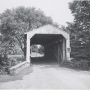
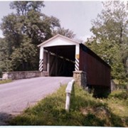
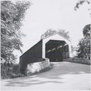
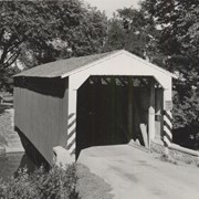
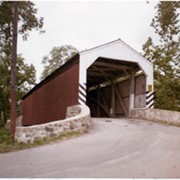
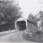
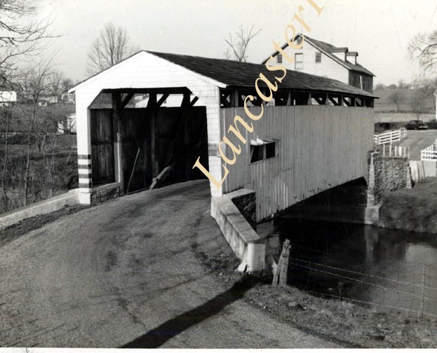
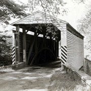
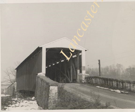
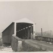
Jacob Landis Mill bridge, one half mile north of Oreville between East Hempfield and Manheim Townships on the Little Conestoga Creek. 53 feet long, built in 1873.
Provenance
digital image only - original owned by Milton Haldeman
Storage Location
LancasterHistory, Lancaster, PA
People
Landis, Jacob
Subcategory
Documentary Artifact
Search Terms
Landis Mill
Oreville, East Hempfield Twp.
Little Conestoga Creek
Covered bridges
Object Name
Print, Photographic
Condition
Good
Object ID
1-09-05-52
Images
Less detail
Collection
General Collection
Title
Rettew Mill Covered Bridge
Object ID
1-21-03-34
Date Range
7 November 1958
  1 image  
Object Name
Print, Photographic
Collection
General Collection
Title
Rettew Mill Covered Bridge
Description
Covered bridge west of Cloister Dairy in Ephrata. Possibly Rettew Mill Covered Bridge.
Date Range
7 November 1958
Creator
Bond, George Ross
Storage Location
LancasterHistory, Lancaster, PA
Storage Room
Archives West
People
Bond, G. Ross
Subject
Photographs
Classification
1-21-03-34
Search Terms
Covered bridges
Rettew Mill Covered Bridge
Cocalico Creek
Place
Ephrata Twp.
Object Name
Print, Photographic
Original or Copy
Original
Print Size
3.25 x 4.75 inches
Dimention Details
Photograph is glued to black paper
Object ID
1-21-03-34
Credit
Courtesy of LancasterHistory, Lancaster, Pennsylvania
Images
Less detail
Collection
General Collection
Object ID
1-09-05-67
  1 image  
Object Name
Print, Photographic
Collection
General Collection
Description
Pine Grove Covered Bridge, located in Little Britain Township on Octoraro Creek. Double span, 204 feet, built in 1884.
Provenance
digital image only - original owned by Milton Haldeman
Storage Location
LancasterHistory, Lancaster, PA
Subcategory
Documentary Artifact
Search Terms
Bridges
Covered bridges
Creeks
Little Britain Twp.
Lower Oxford Twp., Chester County, Pennsylvania
Octoraro Creek, East Branch
Pine Grove Covered Bridge
Place
Little Britain Twp.
Object Name
Print, Photographic
Condition
Good
Object ID
1-09-05-67
Images
Less detail

20 records – page 1 of 1.