It appears no script is enabled within your browser. Please enable JavaScript to use this site.
Skip header and navigation
Toggle navigation
Collections
Search
Help
Privacy
Your Selections:
0
Items
Staff Login
Revise Search
Revise Search
Revise search
Search
Data Source
Photographs
7
×
Data Source
All
A
B
C
D
E
F
G
H
I
J
K
L
M
N
O
P
Q
R
S
T
U
V
W
X
Y
Z
Sort
By Count
Alphabetical
Filtered by
Filter
Loading...
Collection
General Collection
Covered Bridge Album
3
Covered Bridge Safari Album
2
×
Collection
All
A
B
C
D
E
F
G
H
I
J
K
L
M
N
O
P
Q
R
S
T
U
V
W
X
Y
Z
Sort
By Count
Alphabetical
Filtered by
Filter
Loading...
Subject
Documentary Artifact
20
Covered bridges
Reamstown, East Cocalico Twp.
6
Cocalico Creek
4
Bucher's Mill
3
Mills
3
Bands
2
Bridges
2
Farms
2
Fry's Mill Covered Bridge
2
Music
2
Napierville, East Cocalico Twp.
2
More
×
Subject
All
A
B
C
D
E
F
G
H
I
J
K
L
M
N
O
P
Q
R
S
T
U
V
W
X
Y
Z
Sort
By Count
Alphabetical
Filtered by
Filter
Loading...
Place
Manheim Twp.
30
Earl Twp.
11
Ephrata Twp.
11
Caernarvon Twp.
10
Manor Twp.
9
Martic Twp.
8
Bart Twp.
7
Conestoga Twp.
7
East Cocalico Twp.
East Hempfield Twp.
7
Rapho Twp.
7
Colerain Twp.
6
More
×
Place
All
A
B
C
D
E
F
G
H
I
J
K
L
M
N
O
P
Q
R
S
T
U
V
W
X
Y
Z
Sort
By Count
Alphabetical
Filtered by
Filter
Loading...
Decade
1940s
1
1950s
4
×
Decade
All
A
B
C
D
E
F
G
H
I
J
K
L
M
N
O
P
Q
R
S
T
U
V
W
X
Y
Z
Sort
By Count
Alphabetical
Filtered by
Filter
Loading...
Material
Print, Photographic
6
Negative
1
×
Material
All
A
B
C
D
E
F
G
H
I
J
K
L
M
N
O
P
Q
R
S
T
U
V
W
X
Y
Z
Sort
By Count
Alphabetical
Filtered by
Filter
Loading...
Online Media
Image
7
×
Online Media
All
A
B
C
D
E
F
G
H
I
J
K
L
M
N
O
P
Q
R
S
T
U
V
W
X
Y
Z
Sort
By Count
Alphabetical
Filtered by
Filter
Loading...
Advanced Search
Help
more like: E9D48D87-75CD-4CA9-81EF-663987602071
General Collection
Covered bridges
East Cocalico Twp.
Sorted by
Relevance
Sort by Title
Expand All
Collapse All
List View
Gallery View
Print
7 records – page 1 of 1.
Prev
Next
Toggle Full Record
Print, Photographic
https://collections.lancasterhistory.org/en/permalink/d613e041-ac15-4cf3-a27c-835327313140
Collection
General Collection
Title
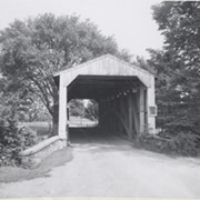
Photograph- Bridge between Ephrata and Reamstown looking from Route 222
Object ID
1-05-03-48
Date Range
April 1948
More detail
1 image
Object Name
Print, Photographic
Collection
General Collection
Title
Photograph- Bridge between Ephrata and Reamstown looking from Route 222
Description
Bridge between Ephrata and Reamstown looking from Route 222
Date Range
April 1948
Storage Location
LancasterHistory, Lancaster, PA
Subcategory
Documentary Artifact
Search Terms
Bridges
Covered bridges
Reamstown, East Cocalico Twp.
Place
East Cocalico Twp.
Object Name
Print, Photographic
Object ID
1-05-03-48
Images
Less detail
More Like This
Permalink
Toggle Full Record
Negative
https://collections.lancasterhistory.org/en/permalink/d2fd2a9e-34e4-4497-97fa-103924958837
Collection
General Collection
Title
Photograph- Covered bridge, possibly near Ephrata and Reamstown. Negative only.
Object ID
1-05-03-70
More detail
1 image
Object Name
Negative
Collection
General Collection
Title
Photograph- Covered bridge, possibly near Ephrata and Reamstown. Negative only.
Description
Covered bridge, possibly near Ephrata and Reamstown. Negative only.
Storage Location
LancasterHistory, Lancaster, PA
Subcategory
Documentary Artifact
Search Terms
Bridges
Covered bridges
Place
East Cocalico Twp.
Object Name
Negative
Object ID
1-05-03-70
Images
Less detail
More Like This
Permalink
Toggle Full Record
Print, Photographic
https://collections.lancasterhistory.org/en/permalink/d04d65e8-7870-4fd8-b68e-747291208920
Collection
General Collection
Object ID
1-09-05-47
More detail
1 image
Object Name
Print, Photographic
Collection
General Collection
Description
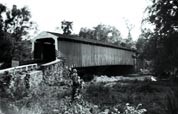
Bucher's Mill bridge, one half mile west of Reamstown in East Cocalico Township on the Cocalico Creek. 60 feet long, built in 1881.
Provenance
digital image only - original owned by Milton Haldeman
Storage Location
LancasterHistory, Lancaster, PA
Subcategory
Documentary Artifact
Search Terms
Bucher's Mill
Reamstown, East Cocalico Twp.
Cocalico Creek
Covered bridges
Place
East Cocalico Twp.
Object Name
Print, Photographic
Condition
Good
Object ID
1-09-05-47
Images
Less detail
More Like This
Permalink
Toggle Full Record
Print, Photographic
https://collections.lancasterhistory.org/en/permalink/b96d083f-bd84-4520-8889-425317504749
Collection
General Collection
Object ID
1-09-03-95
Date Range
August 1956
More detail
1 image
Object Name
Print, Photographic
Collection
General Collection
Description
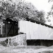
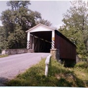
Fry's Mill Covered Bridge on Muddy Creek south of Napierville.
Provenance
Lancaster County covered bridge photos taken by M. E. Schroll and Kathryn L. Sauder taken between 1956 and 1958.
Date Range
August 1956
Storage Location
LancasterHistory, Lancaster, PA
Subcategory
Documentary Artifact
Search Terms
Fry's Mill Covered Bridge
Covered bridges
Muddy Creek
Napierville, East Cocalico Twp.
Place
East Cocalico Twp.
Object Name
Print, Photographic
Print Size
3.5 x 3.5 inches
Condition
Good
Object ID
1-09-03-95
Images
Less detail
More Like This
Permalink
Toggle Full Record
Print, Photographic
https://collections.lancasterhistory.org/en/permalink/b73340d6-40d2-4627-a18c-041821357277
Collection
General Collection
Object ID
1-09-03-96
Date Range
August 7, 1958
More detail
1 image
Object Name
Print, Photographic
Collection
General Collection
Description
Fry's Covered Bridge near Napierville.
Provenance
Lancaster County covered bridge photos taken by M. E. Schroll and Kathryn L. Sauder taken between 1956 and 1958.
Date Range
August 7, 1958
Storage Location
LancasterHistory, Lancaster, PA
Subcategory
Documentary Artifact
Search Terms
Fry's Mill Covered Bridge
Napierville, East Cocalico Twp.
Covered bridges
Place
East Cocalico Twp.
Object Name
Print, Photographic
Print Size
3.5 x 3.5 inches
Condition
Good
Object ID
1-09-03-96
Images
Less detail
More Like This
Permalink
Toggle Full Record
Print, Photographic
https://collections.lancasterhistory.org/en/permalink/458b6e7d-9d80-4cee-bc15-208141417154
Collection
General Collection
Object ID
1-09-03-97
Date Range
September 1956
More detail
1 image
Object Name
Print, Photographic
Collection
General Collection
Description
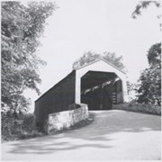
Possibly Bucher's Mill Covered Bridge on the Cocalico Creek west of Reamstown.
Provenance
Lancaster County covered bridge photos taken by M. E. Schroll and Kathryn L. Sauder taken between 1956 and 1958.
Date Range
September 1956
Storage Location
LancasterHistory, Lancaster, PA
Subcategory
Documentary Artifact
Search Terms
Bucher's Mill
Covered bridges
Cocalico Creek
Reamstown, East Cocalico Twp.
Place
East Cocalico Twp.
Object Name
Print, Photographic
Print Size
3.5 x 3.5 inches
Condition
Good
Object ID
1-09-03-97
Images
Less detail
More Like This
Permalink
Toggle Full Record
Print, Photographic
https://collections.lancasterhistory.org/en/permalink/97d6f671-ca87-4aa9-9583-912283397296
Collection
General Collection
Object ID
1-09-03-98
Date Range
August 4, 1958
More detail
1 image
Object Name
Print, Photographic
Collection
General Collection
Description
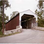
Possibly Bucher's Mill covered bridge on the Cocalico Creek west of Reamstown and east of Ephrata.
Provenance
Lancaster County covered bridge photos taken by M. E. Schroll and Kathryn L. Sauder taken between 1956 and 1958.
Date Range
August 4, 1958
Storage Location
LancasterHistory, Lancaster, PA
Subcategory
Documentary Artifact
Search Terms
Bucher's Mill
Covered bridges
Cocalico Creek
Reamstown, East Cocalico Twp.
Place
East Cocalico Twp.
Object Name
Print, Photographic
Print Size
3.5 x 3.5 inches
Condition
Good
Object ID
1-09-03-98
Images
Less detail
More Like This
Permalink
7 records – page 1 of 1.
Prev
Next