Skip header and navigation

Revise Search

10 records – page 1 of 1.

A battlefield atlas of the Civil War

https://collections.lancasterhistory.org/en/permalink/lhdo1488
Author
Symonds, Craig L.
Date of Publication
c1983.
Call Number
973.7 S988
Responsibility
by Craig L. Symonds ; cartography by William J. Clipson.
ISBN
0933852401 :
Author
Symonds, Craig L.
Place of Publication
Annapolis, Md
Publisher
Nautical & Aviation Pub. Co. of America,
Date of Publication
c1983.
Physical Description
1 atlas (xv, 106 p.) : ill., maps ; 26 cm.
Notes
Bibliography: p. 105-106.
Subjects
United States - History - Civil War, 1861-1865 - Campaigns.
United States - History - Civil War, 1861-1865 - Battlefields - Maps.
United States - History - Civil War, 1861-1865 - Battlefields - Guidebooks.
Additional Author
Clipson, William J.
Location
Lancaster History Library - Book
Call Number
973.7 S988
Less detail

A reference map of Lancaster County, Pennsylvania showing the location and distances of the city, townships, boroughs, post-office and villages, together with the main roads (turnpikes), railroads and railroad stations, also the population of each township and borough as per census of 1890

https://collections.lancasterhistory.org/en/permalink/lhdo1711
Date of Publication
1891
Call Number
974.815 LACO 140
Place of Publication
Lancaster, Pa
Publisher
Burk & McFetridge,lith., Reference Map Co.,
Date of Publication
1891
Physical Description
1 map : linen ; 54 x 56 cm.
Notes
Shows radial distances from Lancaster. Relief shown by hachures. Cloth map. Includes index of places by township.
Subjects
Toll roads - Pennsylvania - Lancaster County
Railroads - Pennsylvania - Lancaster County
Lancaster County (Pa.) - Maps.
Location
Lancaster History Library - Map
Call Number
974.815 LACO 140
Less detail

Map showing location and date of the earliest highways leading from the Delaware and Schulkill Rivers to the Susquehanna River and it's branches / by H. Frank Eshleman

https://collections.lancasterhistory.org/en/permalink/lhdo15534
Author
Eshleman, H. Frank
Date of Publication
1907.
Call Number
974.815 SEPA 100
  1 document  
Author
Eshleman, H. Frank
Place of Publication
Lancaster, Pa
Publisher
H. Frank Eshleman,
Date of Publication
1907.
Physical Description
1 map ; 22 x 41 cm.
Notes
Scale on map [ca. 1:418,176]. 3/4 in. = 5 mi.
May be a reduced reproduction of the original map.
Subjects
Roads - Pennsylvania - Lancaster County - Maps.
Roads - Pennsylvania - Chester County - Maps.
Roads - Pennsylvania - Delaware County - Maps.
Lancaster County (Pa.) - Maps.
Chester County (Pa.) - Maps.
Delaware County (Pa.) - Maps.
Location
Lancaster History Library - Map
Call Number
974.815 SEPA 100
Documents

map_974.815_SEPA_100_.pdf

Read PDF Download PDF
Less detail

Map of the public roads in Lancaster County, Pennsylvania : constructed from actual surveys made under direction of the State Highway Department by authority of an Act of Assembly approved May 31, 1911

https://collections.lancasterhistory.org/en/permalink/lhdo15375
Corporate Author
Pennsylvania. Dept. of Highways.
Edition
Rev. Feb. 1931.
Date of Publication
1931.
Call Number
974.815 LACO 514 Oversize
Corporate Author
Pennsylvania. Dept. of Highways.
Edition
Rev. Feb. 1931.
Place of Publication
[Harrisburg, Pa.]
Publisher
Pennsylvania Dept. of Highways,
Date of Publication
1931.
Physical Description
1 map : col. ; 116 x 114 cm.
Notes
Map includes route numbers, railroads, streams, and important building locations.
"January 1912."
Subjects
Transportation - Pennsylvania - Lancaster County - Maps.
Railroads - Pennsylvania - Lancaster County - Maps.
Lancaster County (Pa.) - Maps.
Location
Lancaster History Library - Map
Call Number
974.815 LACO 514 Oversize
Less detail

Map of the public roads in Lancaster County, Pennsylvania : constructed from actual surveys made under direction of the State Highway Department by authority of an Act of Assembly approved May 1, 1905

https://collections.lancasterhistory.org/en/permalink/lhdo14598
Corporate Author
A. Hoen and Company.
Date of Publication
[1923?]
Call Number
974.815 LACO 517 Oversize
Corporate Author
A. Hoen and Company.
Place of Publication
Baltimore, Md
Publisher
H. Hoen & Co. Lith.,
Date of Publication
[1923?]
Physical Description
1 map : col. ; 99 x 105 cm.
Notes
"April 1, 1923."
Includes table of township road mileages and distance table.
Subjects
Post office buildings - Pennsylvania - Lancaster County - Maps.
Roads - Pennsylvania - Lancaster County - Maps.
Lancaster County (Pa.) - Maps.
Additional Corporate Author
Pennsylvania. Highway Dept.
Location
Lancaster History Library - Map
Call Number
974.815 LACO 517 Oversize
Less detail

The Comprehensive Plan for Lancaster County, Pennsylvania

https://collections.lancasterhistory.org/en/permalink/lhdo14600
Corporate Author
Lancaster County Planning Commission.
Date of Publication
2006.
Call Number
352.96 L245cp
Corporate Author
Lancaster County Planning Commission.
Place of Publication
Lancaster, Pa
Publisher
Lancaster County Planning Commission,
Date of Publication
2006.
Physical Description
4 vol. : ill., maps ; 28 cm.
Notes
Vol 1. Balance: the growth management element, April 2006 - vol. 2. Choices: the housing element, April 2006 - vol. 3. Heritage: the cultural heritage element: a strategy for preserving our sense of place, April 2006 - vol 4. Tourism: the strategic tourism development element, June 2005.
Cover title.
Subjects
Regional planning - Pennsylvania - Lancaster County - Maps.
Regional planning - Pennsylvania - Lancaster County.
Housing - Pennsylvania - Lancaster County.
Historic preservation - Pennsylvania - Lancaster County.
Location
Lancaster History Library - Book
Call Number
352.96 L245cp
Copy Info
2006
2005
Less detail

The Underground Railroad, explorer's map & guide, Lancaster County, Pennsylvania

https://collections.lancasterhistory.org/en/permalink/lhdo15693
Corporate Author
Lancaster County Heritage (Project)
Edition
2nd ed.
Date of Publication
2001.
Call Number
974.815 LACO 107
Alternate Title
Underground Railroad, explorer's map & guide
Underground Railroad explorer's map and guide
Responsibility
Lancaster County Heritage ; brochure design--Lynn M. Stiles, Lancaster County Planning Commission.
Corporate Author
Lancaster County Heritage (Project)
Edition
2nd ed.
Place of Publication
Lancaster, Pa
Publisher
Lancaster County Heritage,
Date of Publication
2001.
Physical Description
1 map ; 19 x 21 cm., on sheet 59 x 42 cm., folded to 10 x 21 cm.
Notes
Shows Underground Railroad routes in Lancaster County (Pa.).
"September 2001."
Includes text, descriptive index of Underground Railroad historic sites, and location map.
Insets: 1. Columbia -- 2. Lancaster City -- 3. Christiana area.
Text, chronology, and ill. on verso.
Subjects
Underground railroad - Pennsylvania - Lancaster County - Maps.
Historic sites - Pennsylvania - Columbia - Maps.
Historic sites - Pennsylvania - Lancaster - Maps.
Historic sites - Pennsylvania - Christiana Region - Maps.
Heritage tourism - Pennsylvania - Lancaster County - Maps.
Additional Author
Stiles, Lynn M.
Additional Corporate Author
Lancaster County Planning Commission.
Location
Lancaster History Library - Map
Call Number
974.815 LACO 107
Less detail

Map of the township of Manor, Lancaster County, Pa

https://collections.lancasterhistory.org/en/permalink/lhdo7488
Date of Publication
1852.
Call Number
974.815 MANO 102
Place of Publication
Philadelphia
Publisher
R. & H. F. Bridgens,
Date of Publication
1852.
Physical Description
1 map photograph 30 x 46 cm.
Notes
Includes inset map of Millerstown and Borough of Washington, and 13 pictures of area farms and buildings.
Has landowners' names.
This is a reduced photographic cop of original wall map.
Subjects
Landowners - Pennsylvania - Manor (Lancaster County, Pa. : Township)
Real property - Pennsylvania - Manor - Manor (Lancaster County, Pa. : Township)
Manor (Lancaster County, Pa. : Township) - Maps.
Location
Lancaster History Library - Map
Call Number
974.815 MANO 102
Less detail

Map of the first settlement of Lancaster County, Pa. October, 1710

https://collections.lancasterhistory.org/en/permalink/lhdo7490
Author
Eshleman, Henry Frank ,
Call Number
974.815 LACO 136
~ i 1 j l I Map 900 136 
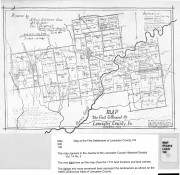
Map of the First Settlement of Lancaster County, PA This map appears in the Journal of the Lancaster County Historical Society Vol. 14 No. 2 The very li9.btlines on this map show the 1710 land divisions and land owners. The darker and more prominent lines represent the
  1 document  
Responsibility
prepared by H. Frank Eshleman Chrmn., A. K. Hostetter, Chas. T. Steigerwalt, Committee of the Lancaster County Historical Society, Jan. 26, 1910.
Author
Eshleman, Henry Frank ,
Physical Description
1 map : photocopy ; 19 x 26 cm.
Notes
"The map numerously cut by lines, figures, roads and names represents the farms, their ownership and size, and the small properties the roads etc. occupying the original tract today V. 12 1910".
Originally published with: Eshleman, Henry Frank Report on the true character, time and place of the first regular settlement in Lancaster County, Lancaster, Pa.: Lancaster County Historical Society, 1910 Historical papers and addresses of the Lancaster County Historical Society, v. 14 no. 2.
Subjects
Land grants - Pennsylvania - Lancaster County
Real property - Pennsylvania - Lancaster County
Pequea Valley (Pa.)
Lancaster County (Pa.) - Maps.
Additional Author
Stagerwalt, Chas. T.
Hostetter, A.K.
Location
Lancaster History Library - Map
Call Number
974.815 LACO 136
Documents

map_974.815_LACO_136_.pdf

Read PDF Download PDF
Less detail

Map of the early roads of Lancaster County, Pa. 1714 to 1760

https://collections.lancasterhistory.org/en/permalink/lhdo15379
Author
Eshleman, H. Frank
Date of Publication
1922]
Call Number
974.815 LACO 158
974.815 LACO 506
  1 document  
Alternate Title
Outline of Lancaster County Penna., townships, streams, etc.
Responsibility
compiled from the records of the courts by H. Frank Eshleman.
Author
Eshleman, H. Frank
Place of Publication
[S.l
Publisher
s.n.,
Date of Publication
1922]
Physical Description
1 map : photoreproduction, 2 col. ; 23 x 24 cm.
Notes
Scale of original map: [ca. 1:316,800]. 1 in. - 5 mi.
Map of early roads of Lancaster County depicted in red outline; Outline of Lancaster County, Penna. townships, streams, etc. depicted in blue outline.
LCHS has 2 copies 60 x 60 cm. with scale 1in.=2mi.
LCHS has 4 copies 23 x 24 cm. with scale 1in.=5mi.
The figures show number and page of Road Docket.
Appears in LCHS Journal, v. 26, no. 3.
Subjects
Roads - Pennsylvania - Lancaster County - Maps.
Rivers - Pennsylvania - Lancaster County - Maps.
Lancaster County (Pa.) - Maps.
Location
Lancaster History Library - Map
Call Number
974.815 LACO 158
974.815 LACO 506
Documents

map_974.815_LACO_158_.pdf

Read PDF Download PDF
Less detail

10 records – page 1 of 1.