LancasterHistory is committed to preserving and providing access to materials chronicling Lancaster County's heritage. As a historical resource, this document reflects the racial prejudices and actions of the era. In order to maintain the historical integrity and context of collection items, LancasterHistory does not censor historical documents or edit language, titles, or organization names when transcribing original content.
Additional Notes
Riot.
1 item, 1 piece
Access Conditions / Restrictions
Request at Reference Desk; photocopy made by staff member.
Shows U.S. county boundary maps for the census decades superimposed on modern county boundaries. Gives background information on each census, including census availability for each county.
Petitions filed for admission to citizenship. Documents may contain: petition number, date, name, nationality, declaration of intention, oath of allegiance, affidavits of witnesses, date admitted in court, and official signatures. Twentieth century petitions may include notes of testimony.
Lancaster County Archives, Lancaster, Pennsylvania
Copies
LancasterHistory, Lancaster, Pennsylvania
Notes
Preferred Citation: Title or description of item, date (day, month, year), Collection, Title and Object ID, Box #, Folder #, LancasterHistory, Lancaster, Pennsylvania.
Access Conditions / Restrictions
Please request at Reference Desk or Research@LancasterHistory.org.
Copyright
Copies of historic Lancaster County, Pennsylvania government records held by LancasterHistory may be published without special permission. There is no fee for publication. Proper credit lines are encouraged in the interest of good documentation.
Credit
Courtesy of Lancaster County Archives and LancasterHistory, Lancaster, Pennsylvania.
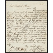
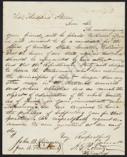
Petition asking Thaddeus Stevens be a Republican candidate for the United States Senate
Description
Petition asking Thaddeus Stevens if he will consent to be a Republican candidate for the Office of United States Senator. Prepared by A. E. Roberts. 33 signatures. Not dated, but Stevens response (MG0115_Part01_F004_In10) is dated 1866.
Preferred Citation: Title or description of item, date (day, month, year), Thaddeus Stevens Collection (MG0115), Part 1, Folder # or Object ID, LancasterHistory, Lancaster, Pennsylvania. URL if applicable. Date accessed (day, month, year).
Access Conditions / Restrictions
Please use digital images and transcriptions when available. Original documents may be used by appointment. Please contact Research@LancasterHistory.org prior to visit.
Copyright
Images have been provided for research purposes only. Please contact Research@LancasterHistory.org for a high-resolution image and permission to publish.
LancasterHistory retains the rights to the digital images and content presented. The doctrine of fair use allows limited use of copyrighted material without permission from the copyright holder. Fair use includes comment, criticism, teaching, and private scholarship. Any images and data downloaded, printed or photocopied for these purposes should provide a citation. All other uses beyond those allowed by fair use require written permission.
Permission for reproduction and/or publication must be obtained in writing from LancasterHistory. Persons wishing to publish any material from this site must assume all responsibility for identifying and satisfying any claimants of copyright or other use restrictions. Publication fees may apply.
Credit
Courtesy of LancasterHistory, Lancaster, Pennsylvania.
Iron, railroad, canal and coal map of Pennsylvania, &c. : showing the relative position of the various anthracite and bituminous coal fields, the railroads, canals and navigable waters by which they are connected forming their respective avenues to market, also the furnaces, rolling mills, bloomeries and forges of Pennsylvania and adjoining states
Shows coal and oil regions from Lake Ontario through much of West Virginia; most of New York State is shown, though without geological detail. Also shows locations of steel works, foundries, etc.
1872 historical topographical atlas of the state of Pennsylvania : with descriptions and county histories, with maps of all counties and major cities, historical, scientific and statistical, together with a map of the United States and territories
Pub. jointly by Carnegie institution of Washington and the American Geographical Society of New York,
Date of Publication
1932.
Physical Description
2 p. β., iii-xv p., 1 β., 162 p., 1 β., 688 maps (part col.) on 166 pl. (part double) 37 cm.
Series
Carnegie Institution of Washington publication
Notes
A collection of maps, cartograms, and reproductions of early maps on many different scales, illustrating the natural environment of the United States and its demographic, economic, political, and military history. The text explains the maps and lists the sources from which they complied.