- Corporate Author
- Conestoga Traction Company.
- Date of Publication
- 1909.
- Call Number
- 974.815 LACO 141
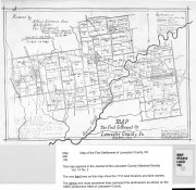
cO ·
LED ANON - - ··-··- ~ · · /
• • - · · - !
JOY
O•# 1,.1;1,r ~
l'IIA..IIW"'"""l"''J'
MAP OF
.Lapcaster County, Pa.
Showing Lines of
Conestoga Traction Company
Figures Give Population of Townships
Scale I inch = 4.61 miles
SUPPLEMENT OF
THE PENNSYLVANIA-GERMAN
AUGUST, 1909
Courtesy, Conestoga