It is late June 1863 in southern Pennsylvania. The Confederates are invading the North, and one of their toughest and most cantankerous generals has decided to capture the grand covered bridge that spans the Susquehanna from Wrightsville to Columbia. From there, General Jubal Early plans to capture Lancaster, and then seize the state's capital, Harrisburg. General Early had orders to destroy it, but intended to capture it on his way to siege the North. Fire on the River tells the story that is often described as a mere skirmish in most history books. What happened in the tiny village of Wrightsville, Pennsylvania, on June 28, 1863, changes the course of the Civil War. Here is the story that for so long has been overlooked in the history books. It is an amazing story of courage, and perhaps not surprisingly, how the U.S. Congress never compensated the bridge's owner for the loss, yet the burning of the covered bridge probably saved the Union. [from Amazon.com]
"Produced for Rivertownes PA USA in commemoration of the 140th anniversary of the burning of the Columbia-Wrightsville Bridge on 28 June 1863, this program narrates the dramatic story of the bridge's destruction and details the valiant attempt of an outnumbered detachment of raw Union militia to halt the advance of Confederate Brigadier General John Gordon's determined veteran infantry."
Also "introduces the poignant, very risky participation of a company of free blacks from Columbia."
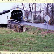
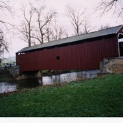
Rettew Mill bridge, also known as Keller's Mill bridge or Guy Bard's covered bridge. Built in 1873 by Elias McMellen. Originally over Cocalico Creek on Rettew Mill Road between Akron borough and Ephrata borough. Currently over Cocalico Creek on Middle Creek Road. Moved in 2010.
Provenance
Photographs of a 2003 Theodore Burr Covered Bridge Society bridge safari.
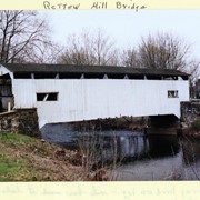
Historic structures Survey and Determination of Eligibility Report : East Lampeter, Leacock, Strasburg, Paradise, Salisbury, and Sadsbury Townships, Lancaster County, Pensylvania
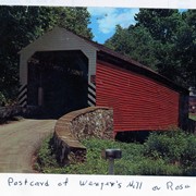
Wenger's Mill covered bridge, also called Rose Hill covered bridge, built in 1849 by Henry Zook. Located on Log Cabin Road, just off of Rose Hill Road. Post card.
Provenance
Photographs of a 2003 Theodore Burr Covered Bridge Society bridge safari.
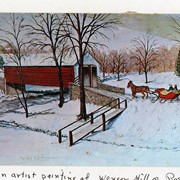
Wenger's Mill covered bridge, also called Rose Hill covered bridge, built in 1849 by Henry Zook. Located on Log Cabin Road, just off of Rose Hill Road. Postcard of painting by Louise Frank.
Provenance
Photographs of a 2003 Theodore Burr Covered Bridge Society bridge safari.
Wenger's Mill covered bridge, also called Rose Hill covered bridge, built in 1849 by Henry Zook. Located on Log Cabin Road, just off of Rose Hill Road.
Provenance
Photographs of a 2003 Theodore Burr Covered Bridge Society bridge safari.