Skip header and navigation

Revise Search

10 records – page 1 of 1.

Bicycle map, Lancaster County : a guide to bicycling, walking & transit

https://collections.lancasterhistory.org/en/permalink/lhdo19792
Corporate Author
Steve Spindler Cartography (Firm)
Date of Publication
[2004]
Call Number
974.815 LACO 513
Alternate Title
Lancaster County bicycle map
Responsibility
map produced for Lancaster County, Pennsylvania ; cartography--Steve Spindler Cartography ; design--Peter Volz Design ; project management--Toole Design Group.
Corporate Author
Steve Spindler Cartography (Firm)
Place of Publication
[Lancaster, Pa.]
Publisher
Lancaster County Planning Commission,
Date of Publication
[2004]
Physical Description
1 map : col. ; 64 x 67 cm., folded to 22 x 10 cm.
Notes
Bicycling conditions shown on road-map base.
Relief shown by shading.
"December 2004."
"Information on this map is accurate as of June 2004."
Title from panel.
Includes text, distance/travel-time table, and col. ill.
Text, directory of bicycle shops, and col. ill. on verso.
Maps on verso: City of Lancaster -- Transit map, Lancaster city routes -- County routes.
Subjects
Bicycle trails - Pennsylvania - Lancaster County - Maps.
Bicycle trails - Pennsylvania - Lancaster - Maps.
Bicycle stores - Pennsylvania - Lancaster County - Maps.
Bus lines - Pennsylvania - Lancaster County - Maps.
Bus lines - Pennsylvania - Lancaster - Maps.
Roads - Pennsylvania - Lancaster County - Maps.
Hiking - Pennsylvania - Lancaster County - Maps.
Additional Corporate Author
Peter Volz Design (Firm)
Toole Design Group.
Lancaster County Planning Commission.
Location
Lancaster History Library - Map
Call Number
974.815 LACO 513
Less detail

Map of the early roads of Lancaster County, Pa. 1714 to 1760

https://collections.lancasterhistory.org/en/permalink/lhdo15379
Author
Eshleman, H. Frank
Date of Publication
1922]
Call Number
974.815 LACO 158
974.815 LACO 506
  1 document  
Alternate Title
Outline of Lancaster County Penna., townships, streams, etc.
Responsibility
compiled from the records of the courts by H. Frank Eshleman.
Author
Eshleman, H. Frank
Place of Publication
[S.l
Publisher
s.n.,
Date of Publication
1922]
Physical Description
1 map : photoreproduction, 2 col. ; 23 x 24 cm.
Notes
Scale of original map: [ca. 1:316,800]. 1 in. - 5 mi.
Map of early roads of Lancaster County depicted in red outline; Outline of Lancaster County, Penna. townships, streams, etc. depicted in blue outline.
LCHS has 2 copies 60 x 60 cm. with scale 1in.=2mi.
LCHS has 4 copies 23 x 24 cm. with scale 1in.=5mi.
The figures show number and page of Road Docket.
Appears in LCHS Journal, v. 26, no. 3.
Subjects
Roads - Pennsylvania - Lancaster County - Maps.
Rivers - Pennsylvania - Lancaster County - Maps.
Lancaster County (Pa.) - Maps.
Location
Lancaster History Library - Map
Call Number
974.815 LACO 158
974.815 LACO 506
Documents

map_974.815_LACO_158_.pdf

Read PDF Download PDF
Less detail

Map of greater Lancaster : including maps of Lancaster City & County

https://collections.lancasterhistory.org/en/permalink/lhdo12833
Corporate Author
R.R. Donnelley and Sons Company. Cartographic Services.
Date of Publication
c1988.
Call Number
974.815 LACO 138
Responsibility
all maps prepared by R.R. Donnelley & Sons Co., Cartographic Services.
Corporate Author
R.R. Donnelley and Sons Company. Cartographic Services.
Place of Publication
Lancaster
Publisher
Lancaster Chamber of Commerce and Industry,
Date of Publication
c1988.
Physical Description
6 maps on 1 sheet : both sides, col. ; 56 x 49 cm. or smaller, sheet 56 x 88 cm.
Notes
Panel title.
"Copyright Bizcorp 1988."
Includes notes, indexes, directories, statistical table, location map inset, and col. ill.
Contents
Greater Lancaster -- Lancaster -- [Central business district] -- [Lancaster County showing points of interest, school districts, and historic districts] -- [Regional location map] -- Lancaster County municipal information.
Subjects
Central business districts - Pennsylvania - Lancaster - Maps.
Historic districts - Pennsylvania - Lancaster County - Maps.
School districts - Pennsylvania - Lancaster County - Maps.
Lancaster (Pa.) - Maps.
Lancaster Metropolitan Area (Pa.) - Maps.
Lancaster County (Pa.) - Maps.
Lancaster County (Pa.) - Maps, Tourist.
Additional Corporate Author
Lancaster Chamber of Commerce and Industry (Pa.)
Bizcorp (Firm)
Location
Lancaster History Library - Map
Call Number
974.815 LACO 138
Less detail

Map of greater Lancaster : including maps of Lancaster City & County

https://collections.lancasterhistory.org/en/permalink/lhdo17339
Corporate Author
R.R. Donnelley and Sons Company. Cartographic Services.
Date of Publication
c1988.
Call Number
974.815 LACI 156
Responsibility
compliments of Franklin & Marshall College ; all maps prepared by R.R. Donnelley & Sons Co., Cartographic Services.
Corporate Author
R.R. Donnelley and Sons Company. Cartographic Services.
Place of Publication
Lancaster
Publisher
The College,
Date of Publication
c1988.
Physical Description
5 maps on 1 sheet : both sides, col. ; 56 x 49 cm. or smaller, sheet 56 x 88 cm., folded to 22 x 19 cm.
Notes
Panel title.
Alternate panel title: Franklin & Marshall.
"Copyright Bizcorp 1988."
Includes notes, indexes, directories, statistical table, location map inset, and col. ill.
Contents
Greater Lancaster -- Lancaster -- [Central business district] -- [Lancaster County showing points of interest, school districts, and historic districts] -- [Regional location map] --[Franklin & Marshall College map].
Subjects
Central business districts - Pennsylvania - Lancaster - Maps.
Historic districts - Pennsylvania - Lancaster County - Maps.
School districts - Pennsylvania - Lancaster County - Maps.
Lancaster (Pa.) - Maps.
Lancaster Metropolitan Area (Pa.) - Maps.
Lancaster County (Pa.) - Maps.
Tourist maps.
Additional Corporate Author
Franklin and Marshall College.
Bizcorp (Firm)
Location
Lancaster History Library - Map
Call Number
974.815 LACI 156
Less detail

Discover cultural treasures, Lancaster County

https://collections.lancasterhistory.org/en/permalink/lhdo19262
Corporate Author
R.R. Donnelley and Sons Company. Mapping Services Division.
Date of Publication
[1991?]
Call Number
974.815 LACO 143
Responsibility
maps by Donnelley Mapping Services.
Corporate Author
R.R. Donnelley and Sons Company. Mapping Services Division.
Place of Publication
Lancaster, PA
Publisher
Cultural Council of Lancaster County,
Date of Publication
[1991?]
Physical Description
2 maps on 1 sheet : both sides, col. ; 34 x 37 cm. and 33 x 37 cm., sheet 47 x 38 cm., folded in cover 24 x 11 cm. + index/directory ([30] p. ; 24 cm.)
Notes
Shows arts organizations, libraries, museums, educational institutions, service organizations, and galleries.
Cover title.
Title at top: Discover cultural treasures.
Copyright "Bizcorp and Cultural Council of Lancaster County."
Includes notes, location map, and sponsors' advertisements.
Contents
Map A. Lancaster County -- Map B. Lancaster : city of Lancaster and vicinity.
Subjects
Arts facilities - Pennsylvania - Lancaster County - Maps.
Arts facilities - Pennsylvania - Lancaster - Maps.
Learned institutions and societies - Pennsylvania - Lancaster County - Maps.
Learned institutions and societies - Pennsylvania - Lancaster - Maps.
Museums - Pennsylvania - Lancaster County - Maps.
Museums - Pennsylvania - Lancaster - Maps.
Lancaster County (Pa.) - Maps, Tourist.
Lancaster (Pa.) - Maps, Tourist.
Additional Corporate Author
Cultural Council of Lancaster County (Pa.)
Bizcorp (Firm)
Location
Lancaster History Library - Map
Call Number
974.815 LACO 143
Less detail

Lancaster with its rail road [sic] connections 1887

https://collections.lancasterhistory.org/en/permalink/lhdo15378
Corporate Author
J. L. Smith Map Publisher.
Date of Publication
[188-?]
Call Number
974.815 LACO 151
  1 document  
Alternate Title
Lancaster with its railroad connections 1887
Responsibility
J. L. Smith Map Publisher.
Corporate Author
J. L. Smith Map Publisher.
Place of Publication
Philadelphia, Pa
Publisher
J.L. Smith Map Publisher,
Date of Publication
[188-?]
Physical Description
1 map ; 35 x 42 cm.
Notes
Date of situation: 1887.
Includes table of distances.
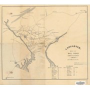
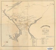
Shows lines for P.W. and B.R.R., B. and O. R.R., Balt. Cent. R.R., P.B.N.G.R.R., C. and P.D.R.R., P.B.R.R., Reading and CHesapeake R.R., CHes. Val. R.R., Lanc. and Del. R.R., Colebrok Valley R.R., and P. and R.R.R.
Subjects
Railroads - Pennsylvania - Lancaster County - Maps.
Mines and mineral resources - Pennsylvania - Lancaster County - Maps.
Location
Lancaster History Library - Map
Call Number
974.815 LACO 151
Documents

map_974.815_LACO_151_.pdf

Read PDF Download PDF
Less detail

Lancaster County bicycle map

https://collections.lancasterhistory.org/en/permalink/lhdo15535
Date of Publication
2004.
Call Number
974.815 LACO 523
Responsibility
Steve Spindler Cartography ; Peter Volz Design ; Toole Design Group.
Place of Publication
[S.l.]
Publisher
Toole Design Group,
Date of Publication
2004.
Physical Description
3 maps on 1 sheet : both sides, col. ill. ; 63 x 67 cm. or smaller, on sheet 63 x 76 cm., folded to 22 x 20 cm.
Notes
"December 2004"--Verso.
"Map produced for Lancaster County, Pennsylvania."
Relief shown in shading.
Includes text, illustrations, table of travel time/distance.
Contents
On verso: City of Lancaster -- Transit map: Lancaster city routes - county routes.
Text. Recto: Bicycle tours of Lancaster County. Verso: Loading your bike onto the bus -- Bike shops and clubs -- Bicycle safety tips.
Subjects
Bicycle trails - Pennsylvania - Lancaster County - Maps.
Cycling - Pennsylvania - Lancaster County - Maps.
Roads - Pennsylvania - Lancaster County - Maps.
Lancaster County (Pa.) - Maps.
Lancaster County (Pa.) - Distances - Maps.
Additional Corporate Author
Steve Spindler Cartography (Firm)
Peter Volz Design (Firm)
Toole Design Group.
Lancaster County Planning Commission.
Location
Lancaster History Library - Map
Call Number
974.815 LACO 523
Less detail

The Underground Railroad, explorer's map & guide, Lancaster County, Pennsylvania

https://collections.lancasterhistory.org/en/permalink/lhdo15693
Corporate Author
Lancaster County Heritage (Project)
Edition
2nd ed.
Date of Publication
2001.
Call Number
974.815 LACO 107
Alternate Title
Underground Railroad, explorer's map & guide
Underground Railroad explorer's map and guide
Responsibility
Lancaster County Heritage ; brochure design--Lynn M. Stiles, Lancaster County Planning Commission.
Corporate Author
Lancaster County Heritage (Project)
Edition
2nd ed.
Place of Publication
Lancaster, Pa
Publisher
Lancaster County Heritage,
Date of Publication
2001.
Physical Description
1 map ; 19 x 21 cm., on sheet 59 x 42 cm., folded to 10 x 21 cm.
Notes
Shows Underground Railroad routes in Lancaster County (Pa.).
"September 2001."
Includes text, descriptive index of Underground Railroad historic sites, and location map.
Insets: 1. Columbia -- 2. Lancaster City -- 3. Christiana area.
Text, chronology, and ill. on verso.
Subjects
Underground railroad - Pennsylvania - Lancaster County - Maps.
Historic sites - Pennsylvania - Columbia - Maps.
Historic sites - Pennsylvania - Lancaster - Maps.
Historic sites - Pennsylvania - Christiana Region - Maps.
Heritage tourism - Pennsylvania - Lancaster County - Maps.
Additional Author
Stiles, Lynn M.
Additional Corporate Author
Lancaster County Planning Commission.
Location
Lancaster History Library - Map
Call Number
974.815 LACO 107
Less detail

The Comprehensive Plan for Lancaster County, Pennsylvania

https://collections.lancasterhistory.org/en/permalink/lhdo14600
Corporate Author
Lancaster County Planning Commission.
Date of Publication
2006.
Call Number
352.96 L245cp
Corporate Author
Lancaster County Planning Commission.
Place of Publication
Lancaster, Pa
Publisher
Lancaster County Planning Commission,
Date of Publication
2006.
Physical Description
4 vol. : ill., maps ; 28 cm.
Notes
Vol 1. Balance: the growth management element, April 2006 - vol. 2. Choices: the housing element, April 2006 - vol. 3. Heritage: the cultural heritage element: a strategy for preserving our sense of place, April 2006 - vol 4. Tourism: the strategic tourism development element, June 2005.
Cover title.
Subjects
Regional planning - Pennsylvania - Lancaster County - Maps.
Regional planning - Pennsylvania - Lancaster County.
Housing - Pennsylvania - Lancaster County.
Historic preservation - Pennsylvania - Lancaster County.
Location
Lancaster History Library - Book
Call Number
352.96 L245cp
Copy Info
2006
2005
Less detail

Lancaster County bus map

https://collections.lancasterhistory.org/en/permalink/lhdo15531
Corporate Author
Red Rose Transit Authority.
Date of Publication
[1987?]
Call Number
974.815 LACI 152
Alternate Title
Lancaster city bus routes
Lancaster County bus routes
Responsibility
Red Rose Transit Authority.
Corporate Author
Red Rose Transit Authority.
Place of Publication
Lancaster, Pa
Publisher
Red Rose Transit Authority,
Date of Publication
[1987?]
Physical Description
10 maps on 1 sheet : both sides, col. ; 60 x 57 cm. or smaller, on sheet 61 x 82 cm., folded to 21 x 12 cm.
Notes
Ancillary maps (recto): Elizabethtown -- Mount Joy -- Columbia -- Willow Street -- Manheim -- Lititz -- Ephrata -- New Holland.
"This map printed 11/87"--Panel.
Text and col. ill. on verso.
Contents
Lancaster County bus routes -- Lancaster city bus routes.
Subjects
Bus lines - Pennsylvania - Lancaster - Maps.
Bus lines - Pennsylvania - Lancaster County - Maps.
Bus lines - Pennsylvania - Elizabethtown - Maps.
Bus lines - Pennsylvania - Mount Joy - Maps.
Bus lines - Pennsylvania - Columbia - Maps.
Bus lines - Pennsylvania - Willow Street - Maps.
Bus lines - Pennsylvania - Manheim - Maps.
Bus lines - Pennsylvania - Lititz - Maps.
Bus lines - Pennsylvania - Ephrata - Maps.
Bus lines - Pennsylvania - New Holland - Maps.
Lancaster (Pa.) - Maps.
Lancaster County - Maps.
Location
Lancaster History Library - Map
Call Number
974.815 LACI 152
Less detail

10 records – page 1 of 1.