It appears no script is enabled within your browser. Please enable JavaScript to use this site.
Skip header and navigation
Toggle navigation
Collections
Search
Help
Privacy
Your Selections:
0
Items
Staff Login
Revise Search
Revise Search
Revise search
Search
Data Source
Photographs
14
×
Data Source
All
A
B
C
D
E
F
G
H
I
J
K
L
M
N
O
P
Q
R
S
T
U
V
W
X
Y
Z
Sort
By Count
Alphabetical
Filtered by
Filter
Loading...
Collection
General Collection
10
Covered Bridge Album
2
Covered Bridge Safari Album
1
Ed Schopf Safe Harbor Collection
1
×
Collection
All
A
B
C
D
E
F
G
H
I
J
K
L
M
N
O
P
Q
R
S
T
U
V
W
X
Y
Z
Sort
By Count
Alphabetical
Filtered by
Filter
Loading...
Subject
Documentary Artifact
69
Conestoga River
55
Bridges
21
Lancaster Twp.
15
Covered bridges
Canal locks
8
Little Conestoga Creek
8
Stone arch bridges
8
Commissioners' Orders for Payment
7
Boards of directors
6
Conestoga Creek
6
Contractors
6
More
×
Subject
All
A
B
C
D
E
F
G
H
I
J
K
L
M
N
O
P
Q
R
S
T
U
V
W
X
Y
Z
Sort
By Count
Alphabetical
Filtered by
Filter
Loading...
Name
Bond, G. Ross
1
Gaintner, Jay Richard
1
Krone, Herbert Brickley
1
Kurtz, Howard G. Sr.
1
Schopf, Edward
1
×
Name
All
A
B
C
D
E
F
G
H
I
J
K
L
M
N
O
P
Q
R
S
T
U
V
W
X
Y
Z
Sort
By Count
Alphabetical
Filtered by
Filter
Loading...
Place
Manheim Twp.
24
Manor Twp.
19
Caernarvon Twp.
16
Earl Twp.
16
West Earl Twp.
13
Conestoga Twp.
12
Lancaster Twp.
Lancaster
8
East Earl Twp.
7
East Hempfield Twp.
Pequea Twp.
3
Ephrata Twp.
2
More
×
Place
All
A
B
C
D
E
F
G
H
I
J
K
L
M
N
O
P
Q
R
S
T
U
V
W
X
Y
Z
Sort
By Count
Alphabetical
Filtered by
Filter
Loading...
Decade
1920s
2
1930s
1
1950s
4
1960s
2
×
Decade
All
A
B
C
D
E
F
G
H
I
J
K
L
M
N
O
P
Q
R
S
T
U
V
W
X
Y
Z
Sort
By Count
Alphabetical
Filtered by
Filter
Loading...
Material
Print, Photographic
13
Negative
1
×
Material
All
A
B
C
D
E
F
G
H
I
J
K
L
M
N
O
P
Q
R
S
T
U
V
W
X
Y
Z
Sort
By Count
Alphabetical
Filtered by
Filter
Loading...
Online Media
Image
14
×
Online Media
All
A
B
C
D
E
F
G
H
I
J
K
L
M
N
O
P
Q
R
S
T
U
V
W
X
Y
Z
Sort
By Count
Alphabetical
Filtered by
Filter
Loading...
Advanced Search
Help
more like: LHDO4000
Lancaster Twp.
East Hempfield Twp.
Covered bridges
Sorted by
Relevance
Sort by Title
Expand All
Collapse All
List View
Gallery View
Print
10 records – page 1 of 1.
Prev
Next
Toggle Full Record
Print, Photographic
https://collections.lancasterhistory.org/en/permalink/9759fced-ae54-4596-adf5-522404582288
Collection
General Collection
Title
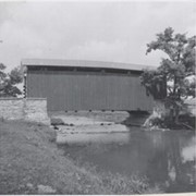
Landis Mill Covered Bridge
Object ID
1-21-03-59
Date Range
22 March 1962
More detail
1 image
Object Name
Print, Photographic
Collection
General Collection
Title
Landis Mill Covered Bridge
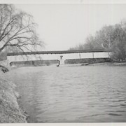
Description
Covered bridge near Landis Mill
Date Range
22 March 1962
Storage Location
LancasterHistory, Lancaster, PA
Storage Room
Archives West
People
Bond, G. Ross
Subject
Photographs
Classification
1-21-03-59
Search Terms
Mills
Covered bridges
Landis Mill Covered Bridge
Landis Mill
Little Conestoga Creek
Place
East Hempfield Twp.
Object Name
Print, Photographic
Original or Copy
Original
Print Size
4 x 5 inches
Dimention Details
Photograph is glued to black paper
Object ID
1-21-03-59
Credit
Courtesy of LancasterHistory, Lancaster, Pennsylvania
Images
Less detail
More Like This
Permalink
Toggle Full Record
Print, Photographic
https://collections.lancasterhistory.org/en/permalink/53929494-68a1-41e5-a964-760230605236
Collection
General Collection
Object ID
1-09-04-08
Date Range
July 1956
More detail
1 image
Object Name
Print, Photographic
Collection
General Collection
Description
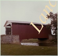
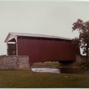
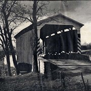
Covered bridge on the Little Conestoga Creek, a short distance north of Oreville.
Provenance
Lancaster County covered bridge photos taken by M. E. Schroll and Kathryn L. Sauder taken between 1956 and 1958.
Date Range
July 1956
Storage Location
LancasterHistory, Lancaster, PA
Subcategory
Documentary Artifact
Search Terms
Oreville, East Hempfield Twp.
Little Conestoga Creek
Covered bridges
Place
East Hempfield Twp.
Object Name
Print, Photographic
Print Size
3.5 x 4.5 inches
Condition
Good
Object ID
1-09-04-08
Images
Less detail
More Like This
Permalink
Toggle Full Record
Print, Photographic
https://collections.lancasterhistory.org/en/permalink/657f51b7-1efa-45ed-86f6-005559072076
Collection
General Collection
Object ID
1-09-04-09
Date Range
August 12, 1958
More detail
1 image
Object Name
Print, Photographic
Collection
General Collection
Description
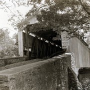
Covered bridge on the Little Conestoga Creek north of Oreville.
Provenance
Lancaster County covered bridge photos taken by M. E. Schroll and Kathryn L. Sauder taken between 1956 and 1958.
Date Range
August 12, 1958
Storage Location
LancasterHistory, Lancaster, PA
Subcategory
Documentary Artifact
Search Terms
Covered bridges
Little Conestoga Creek
Oreville, East Hempfield Twp.
Place
East Hempfield Twp.
Object Name
Print, Photographic
Print Size
3.5 x 4.5 inches
Condition
Good
Object ID
1-09-04-09
Images
Less detail
More Like This
Permalink
Toggle Full Record
Print, Photographic
https://collections.lancasterhistory.org/en/permalink/0d1a3d01-ea5f-45e8-a641-746398347640
Collection
General Collection
Title
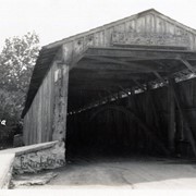
Photograph- Interior of covered bridge at Oreville on the Little Conestoga Creek.
Object ID
1-09-03-37
Date Range
July 1956
More detail
1 image
Object Name
Print, Photographic
Collection
General Collection
Title
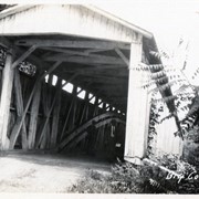
Photograph- Interior of covered bridge at Oreville on the Little Conestoga Creek.
Description
Interior of covered bridge at Oreville on the Little Conestoga Creek.
Provenance
Lancaster County covered bridge photos taken by M. E. Schroll and Kathryn L. Sauder taken between 1956 and 1958.
Date Range
July 1956
Storage Location
LancasterHistory, Lancaster, PA
Subcategory
Documentary Artifact
Search Terms
Covered bridges
Oreville, East Hempfield Twp.
Conestoga Creek
Place
East Hempfield Twp.
Object Name
Print, Photographic
Print Size
3.5 x 3.5 inches
Condition
Good
Object ID
1-09-03-37
Images
Less detail
More Like This
Permalink
Toggle Full Record
Print, Photographic
https://collections.lancasterhistory.org/en/permalink/3827e0a7-d43e-4b31-b438-142339400622
Collection
General Collection
Object ID
1-20-04-69
More detail
1 image
Object Name
Print, Photographic
Collection
General Collection
Description
Bridge number 19 over the Conestoga River - possibly at South Duke Street
Provenance
Photographs taken by Lancaster County during bridge repair work. Gift of Gordon Reed.
Year Range From
1920
Year Range To
1929
Storage Location
LancasterHistory, Lancaster, PA
Search Terms
Covered bridges
Conestoga River
Place
Lancaster Twp.
Object Name
Print, Photographic
Print Size
3.25 x 5.5 inches
Object ID
1-20-04-69
Images
Less detail
More Like This
Permalink
Toggle Full Record
Print, Photographic
https://collections.lancasterhistory.org/en/permalink/d3945053-7eec-4ef9-b7fc-242330775201
Collection
General Collection
Object ID
1-20-04-72
More detail
1 image
Object Name
Print, Photographic
Collection
General Collection
Description
Bridge number 21 over the Conestoga River - possibly on the New Danville Pike
Provenance
Photographs taken by Lancaster County during bridge repair work. Gift of Gordon Reed.
Year Range From
1920
Year Range To
1929
Storage Location
LancasterHistory, Lancaster, PA
Search Terms
Covered bridges
Conestoga River
Place
Lancaster Twp.
Object Name
Print, Photographic
Print Size
3.25 x 5.5 inches
Object ID
1-20-04-72
Images
Less detail
More Like This
Permalink
Toggle Full Record
Print, Photographic
https://collections.lancasterhistory.org/en/permalink/0f2e2d3a-85a9-4176-8f02-358810268710
Collection
General Collection
Object ID
1-09-05-33
Date Range
c. 1960
More detail
1 image
Object Name
Print, Photographic
Collection
General Collection
Description
Covered bridge of Conestoga Creek northwest of Long's Park
Provenance
digital image only - original owned by Milton Haldeman
Date Range
c. 1960
Storage Location
LancasterHistory, Lancaster, PA
Subcategory
Documentary Artifact
Search Terms
Covered bridges
Conestoga Creek
Long's Park
Place
East Hempfield Twp.
Object Name
Print, Photographic
Condition
Good
Object ID
1-09-05-33
Images
Less detail
More Like This
Permalink
Toggle Full Record
Print, Photographic
https://collections.lancasterhistory.org/en/permalink/5810fd5d-3365-4917-a110-155675326037
Collection
General Collection
Object ID
1-09-05-41
More detail
1 image
Object Name
Print, Photographic
Collection
General Collection
Description
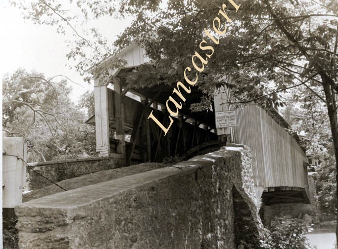
Israel Groff's Factory bridge at water's edge in Lancaster Township, a half mile south of Eden on the Conestoga River. 158 feet long, built in 1848.
Provenance
digital image only - original owned by Milton Haldeman
Storage Location
LancasterHistory, Lancaster, PA
Subcategory
Documentary Artifact
Search Terms
Groff Factory Bridge
Lancaster Twp.
Conestoga River
Covered bridges
Place
Lancaster Twp.
Object Name
Print, Photographic
Condition
Good
Object ID
1-09-05-41
Images
Less detail
More Like This
Permalink
Toggle Full Record
Print, Photographic
https://collections.lancasterhistory.org/en/permalink/5b6b8dfb-1ff1-48cc-a5ac-751117377318
Collection
Ed Schopf Safe Harbor Collection
Object ID
ES-02-02-02
More detail
1 image
Object Name
Print, Photographic
Collection
Ed Schopf Safe Harbor Collection
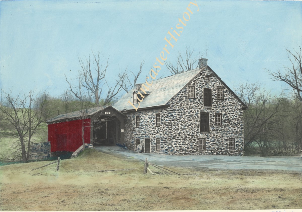
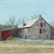
Description
Stoneroads Mill covered bridge, northwest of Bausman. Hand colored.
Provenance
Gift of Amer and Emma Kendig
Creator
Schopf, Edward
Storage Location
LancasterHistory, Lancaster, PA
Subcategory
Documentary Artifact
Search Terms
Covered bridges
Little Conestoga Creek
Bausman, Lancaster Twp.
Place
Lancaster Twp.
Object Name
Print, Photographic
Print Size
4.75 x 6.25 inches
Object ID
ES-02-02-02
Notes
Ed Schopf was plant photographer for the Safe Harbor Water Power Corporation from 1930 to 1954.
Images
Less detail
More Like This
Permalink
Toggle Full Record
Print, Photographic
https://collections.lancasterhistory.org/en/permalink/0c51e65d-e3ae-4893-9001-649599990868
Collection
Covered Bridge Album
Object ID
A-11-01-11
Date Range
1950
More detail
1 image
Object Name
Print, Photographic
Collection
Covered Bridge Album
Description
Wabank, between New Danville and Millersville. State supervised on road LR 36006, built in 1841 (first bridge 1835), double span 246 feet long.
Date Range
1950
Creator
Gaintner, Jay Richard
Storage Location
LancasterHistory, Lancaster, PA
Subcategory
Documentary Artifact
Search Terms
Bridges
Covered bridges
Mills
Conestoga River
Place
Lancaster Twp.
Object Name
Print, Photographic
Print Size
8 x 10 inches
Object ID
A-11-01-11
Images
Less detail
More Like This
Permalink
10 records – page 1 of 1.
Prev
Next