It appears no script is enabled within your browser. Please enable JavaScript to use this site.
Skip header and navigation
Toggle navigation
Collections
Search
Help
Privacy
Your Selections:
0
Items
Staff Login
Revise Search
Revise Search
Revise search
Search
Data Source
Archives
1
Photographs
1
×
Data Source
All
A
B
C
D
E
F
G
H
I
J
K
L
M
N
O
P
Q
R
S
T
U
V
W
X
Y
Z
Sort
By Count
Alphabetical
Filtered by
Filter
Loading...
Collection
General Collection
38
Darmstaetter Collection
24
Heritage Center Collection
15
Eby Shoe Company Album
6
George Steinman Papers, Series 2 Documents, Images, Ephemera
4
Bridge Records
General Thomas Welsh Family Papers
1
Henry Kauffman Photograph Collection
1
James Buchanan Family Papers, Part 7 Jonathan Messersmith Foltz
1
Postcard Collection
×
Collection
All
A
B
C
D
E
F
G
H
I
J
K
L
M
N
O
P
Q
R
S
T
U
V
W
X
Y
Z
Sort
By Count
Alphabetical
Filtered by
Filter
Loading...
Subject
Documentary Artifact
2006
Postcards
81
Written Communication T&E
77
Art
15
Amish
14
Paintings
14
Creeks
13
Hotels
12
Real photo postcards
11
Covered bridges
10
Farms
10
Horses
9
More
×
Subject
All
A
B
C
D
E
F
G
H
I
J
K
L
M
N
O
P
Q
R
S
T
U
V
W
X
Y
Z
Sort
By Count
Alphabetical
Filtered by
Filter
Loading...
Place
Earl Twp. and Ephrata Twp.
1
×
Place
All
A
B
C
D
E
F
G
H
I
J
K
L
M
N
O
P
Q
R
S
T
U
V
W
X
Y
Z
Sort
By Count
Alphabetical
Filtered by
Filter
Loading...
Decade
1990s
1
×
Decade
All
A
B
C
D
E
F
G
H
I
J
K
L
M
N
O
P
Q
R
S
T
U
V
W
X
Y
Z
Sort
By Count
Alphabetical
Filtered by
Filter
Loading...
Material
Map
1
Postcard
1
×
Material
All
A
B
C
D
E
F
G
H
I
J
K
L
M
N
O
P
Q
R
S
T
U
V
W
X
Y
Z
Sort
By Count
Alphabetical
Filtered by
Filter
Loading...
Archival Hierarchy
Item
1
×
Archival Hierarchy
All
A
B
C
D
E
F
G
H
I
J
K
L
M
N
O
P
Q
R
S
T
U
V
W
X
Y
Z
Sort
By Count
Alphabetical
Filtered by
Filter
Loading...
Online Media
Image
×
Online Media
All
A
B
C
D
E
F
G
H
I
J
K
L
M
N
O
P
Q
R
S
T
U
V
W
X
Y
Z
Sort
By Count
Alphabetical
Filtered by
Filter
Loading...
Advanced Search
Help
All Records
Image
Bridge Records
Constables' and Detectives' Bonds
Indictments
Liquor License Papers
Mayor's Court
Postcard Collection
Quarter Sessions
Renunciations
Maps
Sorted by
Relevance
Sort by Title
Expand All
Collapse All
List View
Gallery View
Print
2 records – page 1 of 1.
Prev
Next
Toggle Full Record
Postcard
https://collections.lancasterhistory.org/en/permalink/f0615855-9d59-4401-be2b-237136525053
Collection
Postcard Collection
Title
Map of Lancaster County
Object ID
909-059
Date Range
1990
More detail
1 image
Object Name
Postcard
Collection
Postcard Collection
Title
Map of Lancaster County
Description
Map of Lancaster County surrounded by a red rose, pretzel, locomotive, Conestoga wagon, Amish farm and horse and buggy. Illustration by Frank Hummel.
Date Range
1990
Storage Location
LancasterHistory, Lancaster, PA
Subject
Postcards
Classification
909-059
Search Terms
Maps
Tourism
Illustrations
Object Name
Postcard
Print Size
3.5 x 5.5 inches
Publisher
Scene-Ics, 905 Wakefield Avenue, Mechanicsburg, PA 17055
Object ID
909-059
Credit
Courtesy of LancasterHistory, Lancaster, Pennsylvania
Images
Less detail
More Like This
Permalink
Toggle Full Record
Map
https://collections.lancasterhistory.org/en/permalink/37a8ab0e-64fc-48d9-9977-107455294826
Collection
Bridge Records
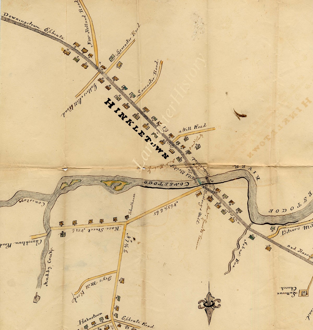
Title
Map of new bridge site
Object ID
Bridge F0215 I001
Date Range
No date
More detail
1 image
Collection
Bridge Records
Title
Map of new bridge site
Description
Earl Twp. and [Ephrata Twp.]
Location: Over Conestoga Creek at Hinkletown, Earl Twp.
Document type: Map of new bridge site
System of Arrangement
Records are arranged by township, then chronologically within each township.
Date Range
No date
Year
none
Storage Location
LancasterHistory, Lancaster, PA
Storage Room
Archives West
Storage Container
Box 0003
Subcategory
Documentary Artifact
Search Terms
Bridges
Conestoga Creek
Creeks
Earl Twp.
Ephrata Twp.
Hinkletown Bridge
Hinkletown, Earl Twp.
Maps
Place
Earl Twp. and Ephrata Twp.
Extent
1 item, 1 piece
Object Name
Map
Language
English
Condition
Fair
Object ID
Bridge F0215 I001
Box Number
003
Access Conditions / Restrictions
Request at Reference Desk; photocopy made by staff member.
Classification
RG 02-00 0324
Description Level
Item
Images
Less detail
More Like This
Permalink